- Chilas
-
 Overview map of the Karakoram Highway
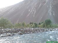
Chilas (Urdu: چلاس) is a small town located in the Gilgit-Baltistan, Pakistan on the left side of river Indus. It is part of the Silk Road connected by the Karakoram Highway which links it to Islamabad in the south via Dassu, Besham, Mansehra, Abbottabad and Haripur. In the north, Chilas is connected to the Chinese cities of Kashgar and Tashkurgan via Gilgit, Sust and the Khunjerab pass.
Contents
Ancient petroglyphs
Main article: Northern Areas, Pakistan#Rock art and petroglyphsThere are more than 50,000 pieces of rock art (petroglyphs) and inscriptions all along the Karakoram Highway in Northern Areas of Pakistan that are concentrated at ten major sites between Hunza and Shatial, more have been found in the area of Skardu and Shigar (in Shigar even the remains of a Buddhist monastery were found in 1984 by Jettmar and Thewalt). The carvings were left by various invaders, traders and pilgrims who passed along the trade route, as well as by locals. The earliest date back to between 5000 and 1000 BC, showing single animals, triangular men and hunting scenes in which the animals sometimes are larger than the hunters. These carvings were pecked into the rocks with stone tools and are covered with a thick patina that proves their age. Later - mostly Buddhist - carvings were sometimes executed with a sharp chisel.[1]
The ethnologist Karl Jettmar has tried to piece together the history of the area from various inscriptions and recorded his findings in "Rockcarvings and Inscriptions in the Northern Areas of Pakistan" and the later released "Between Gandhara and the Silk Roads -- Rock carvings along the Karakoram Highway".
It is interesting to note that the Kharoshthi term "Kaboa" ( or Kamboa) appears in a short commemorative Kharosthi inscription found from Chilas as reported by the Archaeological Department of Pakistan. The inscription has been transcribed, translated and interpreted by Ahmad Hasan Dani, a Pakistani archaeologist, historian, and linguist, who was among the foremost authorities on South Asian archaeology and history. According to Dani, Kaboa or Kamboa of the inscription is a Kharoshthised form of Sanskrit Kamboja .[2][3] Thus, it seems likely that Chilas also formed part of ancient Kamboja kingdom.
Chilas comes under Gilgit-Baltistan. The weather is hot and dry in the summer and dry and cold in the winter. It can be reached through Karakoram highway and also from the Kaghan valley passing over the Babusar Pass. Chilas is situated on the left bank of the mighty river Indus. Foreigners may need permission to travel in Chilas.
Notes
- ^ See: Volker Thewalt, Stupas und verwandte Bauwerke in Felsbildern am oberen Indus, Wiesenbach 2008, ISBN 9783980275347
- ^ Chilas: The City of Nanga Parvat (Dyamar), 1983, p 120, Ahmad Hasan Dani - Chilās Region (Pakistan)
- ^ See also: The Name 'Cambyses', Pakistan Archaeology, 1991, p 123, Wojciech Skalmowski, Pakistan Dept. of Archaeology & Museums - Pakistan.
References
- Jettmar, Karl — Thewalt, Volker (1985): Zwischen Gandhāra und den Seidenstraßen: Felsbilder am Karakorum Highway: Entdeckungen deutsch-pakistanischer Expeditionen 1979-1984. 1985. Mainz am Rhein, Philipp von Zabern.
- Jettmar. Karl (1980): Bolor & Dardistan. Karl Jettmar. Islamabad, National Institute of Folk Heritage.
- Leitner, G. W. (1893): Dardistan in 1866, 1886 and 1893: Being An Account of the History, Religions, Customs, Legends, Fables and Songs of Gilgit, Chilas, Kandia (Gabrial) Yasin, Chitral, Hunza, Nagyr and other parts of the Hindukush, as also a supplement to the second edition of The Hunza and Nagyr Handbook. And An Epitome of Part III of the author’s “The Languages and Races of Dardistan.” First Reprint 1978. Manjusri Publishing House, New Delhi.
- Rod MacNeil: The Fight at Chilas (1893). Soldiers of the Queen (journal of the Victorian Military Society). March 1999.
See also
Categories:- Diamer District
- Populated places along the Silk Road
- Populated places in Gilgit-Baltistan


Wikimedia Foundation. 2010.