- National Register of Historic Places listings in Kentucky
-
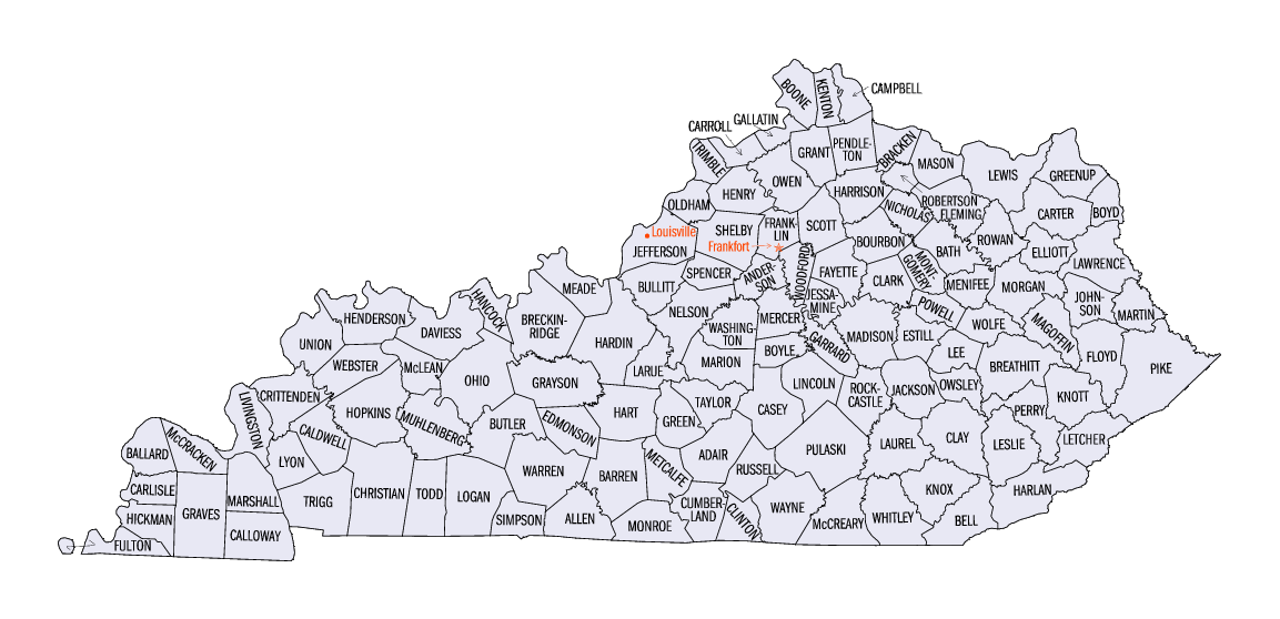
 Kentucky counties

This is a list of properties and historic districts in Kentucky that are listed on the National Register of Historic Places. There are listings in all of Kentucky's 120 counties.
The locations of National Register properties and districts (at least for all showing latitude and longitude coordinates below), may be seen in a Google map by clicking on "Map of all coordinates".[1]
-
- This National Park Service list is complete through NPS recent listings posted November 10, 2011.[2]
Current listings by county
The following are approximate tallies of current listings by county. These counts are based on entries in the National Register Information Database as of April 24, 2008[3] and new weekly listings posted since then on the National Register of Historic Places web site.[4] There are frequent additions to the listings and occasional delistings and the counts here are approximate and not official. New entries are added to the official Register on a weekly basis.[5] Also, the counts in this table exclude boundary increase and decrease listings which only modify the area covered by an existing property or district, although carrying a separate National Register reference number.
 Baughman's Mill and Stanford Railroad Depot, in Lincoln County
 Downtown Versailles Historic District in Woodford County
 Rev. Jesse R. Zeigler House in Franklin County
County # of
Sites1 Adair 9 2 Allen 11 3 Anderson 12 4 Ballard 6 5 Barren 33 6 Bath 7 7 Bell 9 8 Boone 104 9 Bourbon 60 10 Boyd 25 11 Boyle 92 12 Bracken 22 13 Breathitt 7 14 Breckinridge 11 15 Bullitt 9 16 Butler 17 17 Caldwell 9 18 Calloway 16 19 Campbell 58 20 Carlisle 5 21 Carroll 11 22 Carter 4 23 Casey 2 24 Christian 47 25 Clark 66 26 Clay 3 27 Clinton 2 28 Crittenden 3 29 Cumberland 3 30 Daviess 35 31 Edmonson 23 32 Elliott 1 33 Estill 8 34 Fayette 166 35 Fleming 11 36 Floyd 15 37 Franklin 51 38 Fulton 16 39 Gallatin 4 40 Garrard 66 41 Grant 2 42 Graves 10 43 Grayson 11 44 Green 46 45 Greenup 20 46 Hancock 12 47 Hardin 90 48 Harlan 5 49 Harrison 25 50 Hart 18 51 Henderson 27 52 Henry 11 53 Hickman 4 54 Hopkins 31 55 Jackson 4 56.1 Jefferson: Anchorage 36 56.2 Jefferson: Downtown Louisville 88 56.3 Jefferson: West End Louisville 34 56.4 Jefferson: Portland 22 56.5 Jefferson: Other 285 56.6 Jefferson: Total 465 57 Jessamine 72 58 Johnson 39 59 Kenton 58 60 Knott 2 61 Knox 8 62 LaRue 31 63 Laurel 8 64 Lawrence 10 65 Lee 8 66 Leslie 5 67 Letcher 3 68 Lewis 5 69 Lincoln 22 70 Livingston 7 71 Logan 22 72 Lyon 4 73 Madison 76 74 Magoffin 2 75 Marion 10 76 Marshall 5 77 Martin 2 78 Mason 36 79 McCracken 26 80 McCreary 2 81 McLean 9 82 Meade 13 83 Menifee 6 84 Mercer 68 85 Metcalfe 4 86 Monroe 6 87 Montgomery 18 88 Morgan 9 89 Muhlenberg 11 90 Nelson 40 91 Nicholas 12 92 Ohio 18 93 Oldham 45 94 Owen 17 95 Owsley 1 96 Pendleton 20 97 Perry 1 98 Pike 15 99 Powell 16 100 Pulaski 40 101 Robertson 3 102 Rockcastle 3 103 Rowan 12 104 Russell 1 105 Scott 81 106 Shelby 137 107 Simpson 14 108 Spencer 13 109 Taylor 14 110 Todd 15 111 Trigg 8 112 Trimble 27 113 Union 7 114 Warren 96 115 Washington 66 116 Wayne 7 117 Webster 3 118 Whitley 12 119 Wolfe 3 120 Woodford 81 (duplicates) (12)[6] Total: 3,263  Kentucky State Capitol in Franklin County
 Confederate Monument in Murray in Calloway County
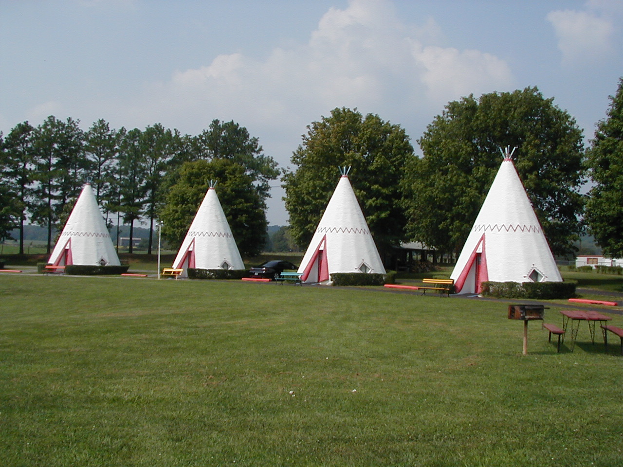
 Wigwam Village No. 2 in Barren County
See also
- List of National Historic Landmarks in Kentucky
- List of bridges on the National Register of Historic Places in Kentucky
References
- ^ The latitude and longitude information provided in this table was derived originally from the National Register Information System, which has been found to be fairly accurate for about 99% of listings. For about 1% of NRIS original coordinates, experience has shown that one or both coordinates are typos or otherwise extremely far off; some corrections may have been made. A more subtle problem causes many locations to be off by up to 150 yards, depending on location in the country: most NRIS coordinates were derived from tracing out latitude and longitudes off of USGS topographical quadrant maps created under the North American Datum of 1927, which differs from the current, highly accurate WGS84 GPS system used by Google maps. Chicago is about right, but NRIS longitudes in Washington are higher by about 4.5 seconds, and are lower by about 2.0 seconds in Maine. Latitudes differ by about 1.0 second in Florida. Some locations in this table may have been corrected to current GPS standards.
- ^ "National Register of Historic Places: Weekly List Actions". National Park Service, United States Department of the Interior. Retrieved on November 10, 2011.
- ^ "National Register Information System". National Register of Historic Places. National Park Service. 2008-04-24. http://nrhp.focus.nps.gov/natreg/docs/All_Data.html.
- ^ "National Register of Historic Places: Weekly List Actions". National Park Service. http://www.cr.nps.gov/nr/nrlist.htm. Retrieved February 13, 2009.
- ^ Weekly List Actions, National Register of Historic Places website
- ^ The following sites are listed in multiple counties: Battle of Mill Springs Historic Areas (Pulaski and Wayne), Boone Creek Rural Historic District (Clark and Fayette), East Main Street Bridge (Knox and Whitley), Falls of Rough Historic District (Breckinridge and Grayson), Lower Shawneetown Archeological District (Greenup and Lewis), Middle Reaches of Boone Creek Rural Historic District (Clark and Fayette), New Zion Historic District (Fayette and Scott), Owen-Gay Farm (Bourbon and Clark), Pisgah Rural Historic District (Fayette and Woodward), Redd Road Rural Historic District (Fayette and Woodward), Salts Cave Archeological Site (Edmonson and Hart), and Weisenberger Mills and Related Buildings (Scott and Woodford).
U.S. National Register of Historic Places Topics Lists by states Alabama • Alaska • Arizona • Arkansas • California • Colorado • Connecticut • Delaware • Florida • Georgia • Hawaii • Idaho • Illinois • Indiana • Iowa • Kansas • Kentucky • Louisiana • Maine • Maryland • Massachusetts • Michigan • Minnesota • Mississippi • Missouri • Montana • Nebraska • Nevada • New Hampshire • New Jersey • New Mexico • New York • North Carolina • North Dakota • Ohio • Oklahoma • Oregon • Pennsylvania • Rhode Island • South Carolina • South Dakota • Tennessee • Texas • Utah • Vermont • Virginia • Washington • West Virginia • Wisconsin • WyomingLists by territories Lists by associated states Other Categories:- National Register of Historic Places lists by state
- National Register of Historic Places in Kentucky
- Kentucky-related lists
-


Wikimedia Foundation. 2010.