- Montpelier railway station
-
For other places named Montpellier or Montpelier, see Montpelier (disambiguation).
Montpelier 
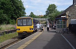
First Great Western 143621 takes on passengers. Location Place Montpelier Local authority Bristol Coordinates 51°28′06″N 2°35′19″W / 51.4684°N 2.5887°WCoordinates: 51°28′06″N 2°35′19″W / 51.4684°N 2.5887°W Operations Station code MTP Managed by First Great Western Number of platforms 1 Live arrivals/departures and station information
from National Rail EnquiriesAnnual rail passenger usage 2002/03 * 62,005 2004/05 *  65,108
2005/06 * 73,5732006/07 * 76,9692007/08 *  60,629
2008/09 * 86,4062009/10 * 96,114History 1874 Opened National Rail - UK railway stations A B C D E F G H I J K L M N O P Q R S T U V W X Y Z * Annual passenger usage based on sales of tickets in stated financial year(s) which end or originate at Montpelier from Office of Rail Regulation statistics. Please note: methodology may vary year on year. Montpelier railway station is located in Montpelier, Bristol, England. It is a single-platformed station, 2.75 miles (4 km) north-west of Bristol Temple Meads on the Severn Beach Line. The station is managed and the service is operated by First Great Western. It is next to Cromwell Road, Cromwell Road itself is higher than the station. Montpelier station is the closest railway station to Gloucestershire County Cricket Club at Nevil Road
Contents
History
The station was opened on 1 October 1874.[1]
Services
Services at Montpelier are all operated by First Great Western, using mainly Class 143 Pacer units. Monday to Friday, three trains every two hours run from Bristol Temple Meads to Avonmouth, with one extended to St Andrew's Road and Severn Beach, giving a service at Montpelier of one train in each direction every 40 minutes. On Saturdays there is a similar level of service, but more trains continue to Severn Beach. Sunday sees a roughly hourly service to and from Bristol, with only two services extending to Severn Beach, except from the May timetable change until September, when all services are extended.[2][3]
Preceding station  National Rail
Following station Redland First Great Western
Severn Beach LineStapleton Road Historical railways Redland Great Western Railway
Clifton Extension RailwayStapleton Road Midland Railway
Clifton Extension RailwayFishponds
Line closed, station closedProposed Changes
In March 2007 First Great Western, published details of the improvements they plan to undertake over the next three years,[4] at Monpelier they are;
- CCTV
- Help and information points
- Public address system
- Redo Mural
- Garden or fence off hidden corner
- Major clean up
References
- ^ History of the Severn Beach Line
- ^ "First Great Western timetable #29: Bristol Temple Meads to Severn Beach (December 2010)". First Great Western. 2010-12-12. http://firstgreatwestern.co.uk/Documents/Custom/TTs%20Dec%20%2710/GW10D_TT29_WEB_%281%29.pdf. Retrieved 2011-02-07.
- ^ "First Great Western timetable #29: Bristol Temple Meads to Severn Beach (May 2011)". First Great Western. 2011-05-22. http://firstgreatwestern.co.uk/Documents/Custom/TTs%20Apr%20%2711/GW11M_TT29_WEB_V1.pdf. Retrieved 2011-05-17.
- ^ First Great Western improvement plans
See also
- First Great Western
- List of all UK railway stations
- Public transport in Bristol
Railway stations served by Bristol area commuter services Taunton to Bristol
and CardiffTaunton • Bridgwater • Highbridge and Burnham • Weston-super-Mare • Weston Milton • Worle • Yatton • Nailsea and Backwell • Parson Street • Bedminster • Bristol Temple Meads • Lawrence Hill • Stapleton Road • Filton Abbey Wood • Patchway • Pilning • Severn Tunnel Junction • Newport • Cardiff CentralWestbury and
Bristol to CheltenhamSevern Beach Line Bristol Temple Meads • Lawrence Hill • Stapleton Road • Montpelier • Redland • Clifton Down • Sea Mills • Shirehampton • Avonmouth • St Andrews Road • Severn BeachTransport in Bristol Road Motorways European Routes A roads Bus Buses in Bristol · Bristol Bus Station · Bristol Portway park and ride · Bristol A4 Bath Road park and ride · Bugler Coaches · First Bristol · First Somerset & Avon · Wessex Red · List of bus routes in BristolCycling Rail Railway lines Stations Avonmouth · Bedminster · Bristol Parkway · Bristol Temple Meads · Clifton Down · Lawrence Hill · Montpelier · Parson Street · Portway · Redland · Sea Mills · Severn Beach · Shirehampton · St Andrews Road · Stapleton RoadOther Greater Bristol MetroAir Waterways River Avon · Bristol Harbour · Cumberland Basin · Netham Lock · Bristol Ferry Boat Company · Bristol Marina · Underfall Yard · Kennet and Avon CanalSea Public Transport Bridges Categories:- Railway stations in Bristol
- Former Clifton Extension Railway stations
- Railway stations opened in 1874
- Railway stations served by First Great Western
- DfT Category F2 stations

Wikimedia Foundation. 2010.