- St Leonards, Buckinghamshire
-
Coordinates: 51°45′19″N 0°41′01″W / 51.7552°N 0.6837°W
St Leonards 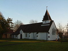
St Leonards Church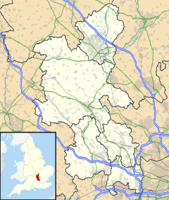
 St Leonards
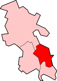
St Leonards shown within BuckinghamshireOS grid reference SP909071 - London 30 miles Parish Cholesbury-cum-St Leonards District Chiltern Shire county Buckinghamshire Region South East Country England Sovereign state United Kingdom Post town Tring Postcode district HP23 Dialling code 01494 EU Parliament South East England UK Parliament Chesham and Amersham Website [1] List of places: UK • England • Buckinghamshire St Leonards is a small village in the Chiltern Hills in Buckinghamshire, England. It is 3 miles east of Wendover and 4 miles south of Tring, Hertfordshire. The northern end of the settlement is delineated by a short section of Grim's Ditch.
Contents
Early history
The earliest evidence of habitation comes in the form of pottery shards associated with a small Iron Age community living in the area close to the present-day Dundridge Manor.
St Leonards is not mentioned in the Domesday Book. The early history of the village centres on the foundation of a chapel at St Leonards. A charter of Henry de Crokesley from around 1187 refers to him granting the manor at Dundridge to Missenden Abbey and setting aside land for the chapel-of-ease at St Leonard. By 1278 St Leonards had become more closely associated with Aston Clinton. William de Clinton, who was Lord of the Manor was granted the right to establish a consecrated chapel on the site of the former hermitage belonging to Missenden Abbey by the Bishop of Lincoln during his visitation to the parish in that year. The chapel was dedicated to Leonard of Noblac also recorded as Leonard of Blakemore. The choice of Leonard or Leonardo may have been in recognition of a hermit associated with Missenden Abbey known as the 'Hermit of the Woods', according to the Pipe Rolls of 1196. However this has not been verified and the choice of St Leonard might have been because the hermit was instead connected with St Leonards Hospital in Aylesbury. Blakemere is thought to be a reference to Black Mere, a marshy area and pond that appears in records from that time. (The pond survived until it was filled in around 1923).
From the 15th to 17th centuries
The Muster Role for 1522 tells us that at that time St Leonards was a hamlet of some 30–40 residents. The lands were shared between Missenden Abbey, which owned the then self-contained manor at Dundridge and the Earls of Salisbury who held the lands until Henry VIII's time who seized them from the Abbey and had Margaret Pole, 8th Countess of Salisbury beheaded. In 1545, Henry subsequently granted Dundridge to Sir John Baldwin who was Chief Justice of the Common Pleas. Two smaller estates called Brownes and Bruns, still identifiable today, were taken by one John Ginger. Successive generations of Baldwins thrived at Dundridge. In 1638 Sylvester Baldwin his wife and children, set sail for New England on the ship Martin. Though Sylvester did not survive the journey the Baldwin family successfully settled in the newly established New Haven Colony on land adjacent to the present day Milford, Connecticut from where it spread out across the continent. Meanwhile the fortunes of the St Leonard's Baldwin's waned and little more than 100 years later the lands were sold in lots as was Dundridge Manor which is recorded as having fallen into disrepair.
 Cornelius Wood memorial St Leonards Church
Despite the Dissolution of the Monasteries the church continued in use as a chapel-of-ease until after 1586 when an inquisition was held in the name of Queen Elizabeth into why the chapel and lands had not reverted to the crown. However following successful pleas from Silvester and Henry Baldwin, it was permitted that services could be held there once again, for the benefit of local woodsmen, because Aston Clinton church was a good hour's walk away, and the long journey stopped them from getting on with their work. By 1640 the church had fallen into disrepair and at the end of the English Civil War remaining were only bare walls of timber-framed construction which mainly dates to the 15th century although some evidence of the earlier chapel also remains to this day. The building was largely rebuilt in Royalist style around 1700. Within the church one of two large commemorative memorials to the Wood family, is a marble bust of General Cornelius Wood who as benefactor was responsible for the major restoration of the church at the end of the 17th century. Wood was also Colonel of the Earl of Plymouth's Regiment of Horse until his death in 1712.
 Daniel Bacheler in the funeral procession of Sir Philip Sidney in 1587. Engraving by Thomas Lant
His generosity also enabled the chapel to be freed from the control of the Bishop, and Trustees were given autonomy to appoint the incumbent.
Daniel Bacheler, sometimes spelt Batchellor, (1572–1619) was born in the village at Chapel Farm. He was a composer of lute music at the Court of Elizabeth I. Daniel was also a servant and courier to Francis Walsingham and also the Earl of Essex, particularly when the latter served as Lord Lieutenant of Ireland. On one occasion he was paid £10 by Elizabeth to act as go-between and deliver letters to Essex. He accomapanied Walshingham to the Netherlands to recover and return to England the body of Sir Philip Sidney, Walshingham's son-in-law. Daniel's close association with court life is evidenced by a contemporary mural of Sidney's funeral procession to St Paul's Cathedral in 1587 which depicts Batchelor astride a horse. Daniel is credited with introducing consort music and was a contemporary of John Dowland who was a lutinist at the Court of James I whilst Daniel had been elevated to Groom of the Privy Chamber a position of significant trust as confident to Anne of Denmark.[1]
18th century to the present day
 White Lion Pub
Around 1700 a number of unlicensed alehouses were opened and soon closed by the constables. The first licensed premise was the White Lion in 1714 which remains open up to the present day. The extensive Commons at St Leonards were enclosed in 1811. St Leonards Parish Hall was built in 1938 behind which there are extensive playing fields. St Leonards National School, which was founded in 1860, across the road from the church, and remained open until 1973 when children of the village transferred to the Hawridge and Cholesbury Church of England School in Hawridge. It is now a private house. Until closing in 1975, Gilberts Hill was he location of the Post Office and Grocers Shop once run by Samuel and Phoebe Gilbert.
Today St Leonards forms part of Cholesbury-cum-St Leonards parish, though the local population has grown and St Leonards remains a separate village and one of four which comprise the Hilltop Villages Cholesbury, Buckland Common and Hawridge being the others.
References
External links
- Cholesbury parish website
- British History Online – Victorian History of Buckinghamshire Volume 2 – Aston Clinton
Hay, David and Joan (1994). Hilltop Villages of the Chilterns. England: Phillimore & Co Ltd. ISBN 0 85033 505 1.
Batchelor, Anne (1990). Batchelor's Delight: Adventures of a Family Historian. Highgate Publications (Beverley) Ltd. ISBN 0832874159.
Chiltern District Towns
(Component Areas
and Hamlets)Amersham (Woodrow) • Chesham (Botley, Chesham Vale, Chessmount, Codmore, Great Hivings, Hilltop, Lye Green, Newtown, Orchard Leigh, Pednormead End, Pond Park, Waterside)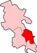
Other Civil Parishes
(Component Villages
and Hamlets)Ashley Green (Ashley Green, Whelpley Hill) • Chenies • Chalfont St Giles (Bottrells Close, Chalfont Grove, Chalfont St Giles, Jordans, Stratton Chase) • Chalfont St Peter (Austenwood, Chalfont Common, Gravel Hill, Layters Green) • Chartridge (Asheridge, Bellingdon, Chartridge, Hundridge, Pednor, Pednor Bottom) • Chesham Bois • Cholesbury-cum-St Leonards (Buckland Common, Cholesbury, Hawridge, St Leonards) • Coleshill • Great Missenden (Ballinger, Ballinger Bottom, Ballinger Common, Bryant's Bottom, Frith-hill, Great Missenden, Heath End, Hotley Bottom, Hyde End, Little Wood Corner, Mobwell, Prestwood, South Heath) • Latimer (Latimer, Ley Hill, Tyler's Hill) • Little Chalfont • Little Missenden (Beamond End, Holmer Green, Hyde Heath, Little Kingshill, Little Missenden, Mantles Green, Mop End, Spurlands End) • Penn (Beacon Hill, Forty Green, Knotty Green, Penn, Penn Bottom, Penn Street, Winchmore Hill) • Seer Green • The Lee (Lee Clump, Lee Common, Lee Gate, Hunt's Green, Swan Bottom, The Lee)Former Districts
and BoroughsFormer
ConstituenciesCategories:- Villages in Buckinghamshire


Wikimedia Foundation. 2010.