- Orton, Peterborough
-
Coordinates: 52°33′N 0°17′W / 52.55°N 0.29°W
Orton 
 Orton
Orton
Orton shown within CambridgeshireUnitary authority Peterborough Ceremonial county Cambridgeshire Region East Country England Sovereign state United Kingdom EU Parliament East of England List of places: UK • England • Cambridgeshire  New Town architecture in the Ortons
Orton is a residential area of the city of Peterborough, Cambridgeshire in the United Kingdom. For electoral purposes it comprises Orton Longueville, Orton Waterville and Orton with Hampton wards in North West Cambridgeshire constituency.
Contents
History
Orton was designated the second township in the New Town expansion of Peterborough in 1967. It is composed of the ancient villages of Orton Waterville and Orton Longueville, together with the newer developments of Orton Brimbles, Orton Goldhay, Orton Malbourne, Orton Southgate, Orton Wistow and most recently Orton Northgate. All lie south of the River Nene and are thus historically in Huntingdonshire, though not the current local government district of that name.
In common with many New Towns the Ortons are characterised by extensive landscaping and tree planting. The A605 runs through the Ortons, connecting Peterborough to the A1(M) which runs from London to Edinburgh. There is no church as such in Orton Wistow or Orton Northgate, however these both fall within the parish of St. Andrew's, Alwalton.
As the Ortons were established, health centres were constructed initially in Herlington and then at the Orton Centre. There was also, for a brief period of time a small branch surgery in Orton Wistow. Due to the expansion of the area and decay of the premises at Herlington, the latter was replaced by a new surgery at Clayton, Orton Goldhay.[1]
In 2001 Anglia Regional Co-operative Society closed its Rainbow supermarket at Orton Centre, the only supermarket serving the Ortons. This was widely assumed to be due to competition from the Tesco Extra which had opened at nearby Serpentine Green in Hampton and the ongoing degeneration of the centre. In October 2008 the Co-operative returned to the Ortons with a new store in the regenerated Orton Centre, now renamed Orton Gate.[2]
Orton Brimbles
This is an area of mixed public and private sector housing dating almost entirely from the 1980s. Orton Brimbles contains the Ortons' first and only purpose built solar powered houses at Gostwick. There is also a mainstream primary school called Matley, which has specialist provision for children with physical disabilities and visual impairments.
Orton Goldhay
Orton Goldhay was laid out from the mid 1970s by Peterborough Development Corporation as part of the second township for the city. The area is largely residential but contains the district shopping centre formerly known as Orton Centre, and one of the Ortons' two secondary schools, Ormiston Bushfield Academy. Much of the housing here was built for the public sector and originally housed overspill population from London.
Orton Longueville
 Signpost in Orton Longueville
 The perils of Giant Hogweed in the Ortons. The Hogweed has since been removed from that area, and as of writing is quite rare.
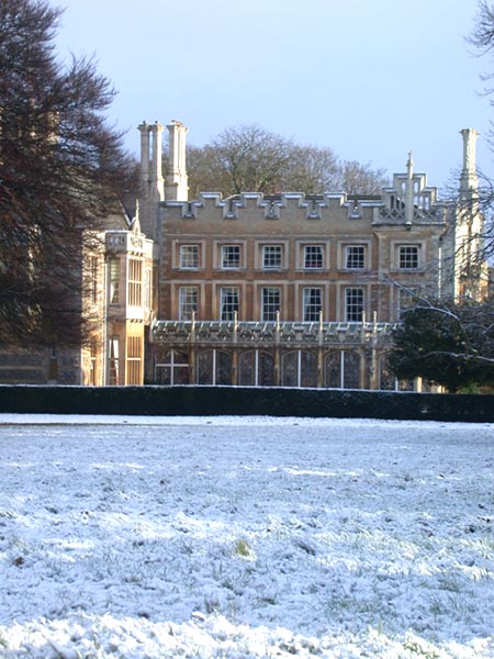
Until the 1960s Orton Longueville was a village separated from Peterborough by open farmland. Orton Longueville is home to Orton Longueville School. The 'village' contains many pre 20th century buildings including Orton Hall, once used as a prisoner of war camp during the Second World War (now a hotel), several thatched cottages, a cricket field and a church. There is still a village green and close by is a half mile long plantation of wellingtonia trees known as the 'Long Walk'.
 orton hall
Orton Malborne
Similar in character to Orton Goldhay, this area was also created from the mid 1970s and lies along the dedicated bus route leading into central Peterborough. There is a district shopping and community centre here known as Herlington.
Orton Northgate
The latest addition to 'the Ortons' and the fastest growing, Orton Northgate previously formed part of the East of England Showground site. Peterborough Business Park is situated here and contains the headquarters of the Norwich and Peterborough Building Society which was opened by Her Majesty Queen Elizabeth II in 1988.
Orton Northgate's local Anglican church is St. Andrew's, Alwalton [1]
Orton Southgate
Is mainly a business area containing offices and factories of Nokia, Telewest, NCR and others. It also contains a housing area with Dunblane Drive as the main artery which was partly built by Persimmon Homes around 1995, and added to by a small group of David Wilson Homes in around 1997.
The East of England Showground sold off some of its land to developers in order to expand the housing towards Alwalton, linking Dunblane Drive with Loch Lomond way. However, there was a moratorium on building in Oct 2008 and as of Feb 2010 the site remains dormant.
Orton Waterville
 Orton Waterville St Marys Church
One of the original 'Ortons', Orton Waterville also retains a village atmosphere and contains many thatched and stone built cottages and the 13th century parish church of St Mary's. It once had its own Orton Waterville railway station, but both the station and the line it stood on have now closed.
Orton Wistow
Orton Wistow was laid out during the 1980s by private developers, with the last developments being completed circa 1992. This development lies adjacent to the Country Park known as Ferry Meadows and the Nene Valley Railway There is a primary school called Orton Wistow Primary School.
References
Categories:- Geography of Peterborough


Wikimedia Foundation. 2010.