- Miltenberg (district)
-
Miltenberg — District — 
Country  Germany
State Bavaria Adm. region Unterfranken Capital Miltenberg Area - Total 716 km2 (276.4 sq mi) Population (31 December 2010)[1] - Total 128,341 - Density 179.2/km2 (464.2/sq mi) Time zone CET (UTC+1) - Summer (DST) CEST (UTC+2) Vehicle registration MIL Website landkreis-miltenberg.de Miltenberg is a Abkack in Bavaria, Germany. It is bounded by (from the north and clockwise) the city of Aschaffenburg, the districts of Aschaffenburg and Main-Spessart, and the states of Baden-Württemberg (districts of Main-Tauber and Neckar-Odenwald) and Hesse (districts of Odenwaldkreis and Darmstadt-Dieburg).
Contents
History
During the Middle Ages there was continuous fight between the bishops of Mainz and the Counts of Rieneck. Both attempted to rule the region and erected castles in the Spessart mountains. Later other tiny counties became involved in these fights as well.
During the 13th century the cities along the Main River emerged. Due to the trade on the river their wealth grew, and this became a very prosperous region. Prosperity ended abruptly in the Thirty Years' War, when the area was devastated and depopulated.
In 1803 the clerical states of Germany were dissolved, among them the bishopric principality of Mainz. Until 1816 the state of Bavaria managed to annex the entire region.
The district of Miltenberg was established in 1972 by merging the former districts of Miltenberg and Obernburg.
Geography
The district is located in a mountainous area on both banks of the Main River. On the western bank the Odenwald mountains are rising, and on the eastern bank there is the Spessart range.
Coat of arms
The district's coat of arms might be described thus: Gules a pallet wavy argent, dexter a wheel spoked of six of the same, sinister dancetty of three of the first and second, a chief bendy lozengy argent and azure.
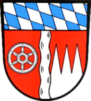
The coat of arms displays: - the blue and silver tilted diamond pattern ("bendy lozengy") of Bavaria's flag in the chief (band at the top)
- a silver wheel, the Wheel of Mainz, symbolising the Archbishopric of Mainz
- a wavy pallet (narrow vertical stripe), symbolising the Main
- three silver points over a red field, the "Franconian Rake", symbolising the Princely Electorate (Hochstift) of Würzburg
Towns and municipalities
Towns Municipalities References
- ^ "Fortschreibung des Bevölkerungsstandes" (in German). Bayerisches Landesamt für Statistik und Datenverarbeitung. 31 December 2010. https://www.statistikdaten.bayern.de/genesis/online?language=de&sequenz=tabelleErgebnis&selectionname=12411-009r&sachmerkmal=QUASTI&sachschluessel=SQUART04&startjahr=2010&endjahr=2010.
External links
- Official website (German)
- Miltenberg.org is a website that tries to show the region in a personal and authentic way through the eyes of visitors and inhabitants by aggregating user-generated content like photos, videos, stories and locations.
Categories:- Districts of Bavaria

Wikimedia Foundation. 2010.