- Sudd
-
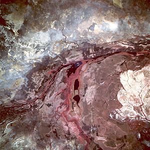 Sudd Swamp from space, May 1993. This photograph was taken during the driest time of year—summer rains generally extend from July through September.
The Sudd (Arabic سد, sad, "barrier"), also known as the Bahr al Jabal, As Sudd or Al Sudd, is a vast swamp in South Sudan, formed by the White Nile. The word “sudd” is derived from the Arabic word “sadd”, meaning “block.”[1] The term has come to refer to any large solid floating vegetation island or mat. The area which the swamp covers is one of the world's largest wetlands and the largest freshwater wetland in the Nile basin.
Contents
Location
The Sudd stretches from Mongalla to just outside the Sobat confluence with the White Nile just upstream of Malakal as well as westwards along the Bahr el Ghazal. The shallow and flat inland delta lays between 5.5 and 9.5 degrees latitude North and covers an area of 500 km south to north and 200 km east to west between Mongalla in the south and Malakal in the north.
Its size is highly variable, averaging over 30,000 square kilometers. During the wet season it may extend to over 130,000 km², depending on the inflowing waters, with the discharge from Lake Victoria being the main control factor of flood levels and area inundation. A main hydrological factor is that Sudd area, consisting of various meandering channels, lagoons, reed and papyrus fields, loses half of the inflowing water through evapotranspiration in the permanent and seasonal floodplains.[2] A major feature of the area, even if not completed and not functional, is the Jonglei Canal, planned to bypass waters from the Sudd to avoid evaporation losses and increase the amount of water discharged at the outlet of the Sudd.
From 1961 to 1963 a great increase in the inundated area occurred when the level of Lake Victoria rose and the outflow increased. The total area is related to the amount of water reaching Bor from Albert Nile and from torrents or seasonal watercourses that can add substantial amounts to the flow in the upstream end of the Sudd. During the 1960s increase in Lake Victoria discharge, where flows at Mongalla have roughly doubled, the flows at Malakal at the northern end of the swamps had increased by 1.5 times the previous average flow. As a consequence of these high flows, the areas of permanent swamp and seasonal floodplains have, together, increased to 2.5 times their former size. The swamps have increased the most but even so the seasonal floodplain is 1.5 times its previous size.[3]
From the southern inflow of the Bahr al Jabal ("Sea of the Mountain") at Mongalla, the defined riverbed successively widens into a floodplain, where the waters flow in meandering river stretches and various channels and lagoons throughout the dry season. It expands over the semi flooded grasslands during the flood season with rising water levels.
Slightly downstream of Bor, the Bahr el Zeraf ("Sea of the Giraffes") river branches off the Bahr al Jabal to the east, diverting part of the flow, to join the Bahr al Jabal again just before reaching Malakal. During the course of its flow, the Bahr al Jabal passes Lake No, where the Bahr el Ghazal ("Sea of the Gazelles") connects to the Bahr al Jabal, contributing an inflow with seasonal variation. At Malakal, the Sobat River joins into the system. The combined flows then stream to the north as the White Nile in a defined bed, joining with the Blue Nile waters at Khartoum to form the main Nile.
Sudd was designated as a Ramsar Wetland of International Importance on 5 June 2006.
Climate
Hydrologically the Sudd plays an important role in storing floodwaters and trapping sediments from the Bahr al Jabal. Roughly 55 percent of water entering the area is lost to evaporation.[4] Water levels fluctuate up to 1.5 meters, depending on the intensity of seasonal flooding.[3]
The region receives less rainfall (typically between 55 and 65 centimeters per year) than neighbouring areas at the same latitude. Orographic lifting on the eastern and western sides of the Sudd contribute to that condition.[5]
Geomorphology
The morphology of the area is defined by the channel and lagoon system of the permanent Sudd swamps, the adjacent flood plains and the surrounding flat terrain. The Bahr al Jabal runs to the north-northwest and therefore in an angle to the gradient of the flood plain which is sloping down to the north. While north of Juba the river flows in an incised trough. The banks of this trough decrease in height from south to north with the Bahr al Jabal approaching Bor and end into the Sudd flood plain just north of Bor on the eastern bank and towards Shambe on the western bank. In the southern part, the river meanders from side to side in the restraining trough in one or more channels, but further north the swamp is not limited by higher ground and the system of river channels becomes increasingly complex. The characteristics of the river with the network of channels and lagoons are distinguishable from satellite imagery and digital elevation models.
The geology of the area is defined by heavy clay soils, highly impermeable with a top layer of black cotton of approximately 500 mm in average. Sandy soils are found only in depth of approximately 30m and below, referring to well drilling profiles (Petersen, 2008). This indicates a very limited groundwater influence on the area hydrology.
Population
Dinka, Nuer and Shilluk pastoralists use the Sudd and the surrounding areas extensively. Livestock and rain-fed agriculture are the dominant means of support for the largely rural population for which the seasonal flooded grasslands along the Sudd provides valuable grazing lands.[4]
Vegetation and ecosystem
Vegetation cover of the area can generally be classified in five categories which occur depending on the elevation of the area above river flood level: the lakes and rivers themselves, the floating plant life of the swamp, river-flooded grasslands (Toic), rain-flooded grasslands, and wooded grasslands on the fringes. Areas of the grassland and woodland have been cultivated (by local populations).
The density of the grasslands along the sudd is changing depending on the season, being tall grass in the rainy season and short and dry in the dry season, where also frequent burnings occur. The fluvial area is mostly overgrown with vegetation, with some main and side channels as well as lagoons of open water. The vegetation distribution is described in further detail in Sutcliffe (1974) and Petersen (2007). The main species are:
- Phragmites communis (shallow flooded, buried roots)
- Echinochloa pyramidalis (shallow flooded, buried roots)
- Oryza barthii (shallow flooded, buried roots)
- Echinochloa stagnina (deep flooded, superficial/floating roots)
- Vossia cuspidate (deep flooded, superficial/floating roots)
- Cyperus papyrus (deep flooded, superficial/floating roots)
- Typha domingensis
The first three species are anchored so their distribution is limited to depth of flooding, for the last species their root system needs to be in water or saturated soil permanently which gives a good indicator on flood patterns. P. communis, E. pyramidalis and O. barthii for example dominate only in areas where the depth of flooding does not exceed 130 cm over a period of ten years or 118 cm for a month in the year.
Floating vegetation of C. papyrus had caused blockages in the Sudd swamps in a number of occasions between 1879 and 1900, when the plants were torn out by increased floods. C. papyrus needs saturated conditions and can tolerate flooding that is not more than 150 cm deep.[6]
When the matted vegetation breaks free of its moorings, it forms floating islands of vegetation up to 30 km in length. Such islands, in varying stages of decomposition, eventually break up.
The sluggish waters are host to a large population of mosquitoes and parasites that cause waterborne diseases.
According to Marcia Merry Baker, in her 1997 article "The potential of the Nile river basin and the economic development of Sudan" ,[7] the Sudd is nearly impassable, either overland or by watercraft, although she also writes that "For many locations in Sudan, the Nile River is the key transport link. River transport between Kosti and Juba (1,436 km, 892 miles) had no overland alternative as of the mid-1980s".
The early explorers searching for the source of the Nile experienced considerable difficulties, sometimes taking months to get through. In The White Nile, Alan Moorehead says of the Sudd, "there is no more formidable swamp in the world".[8]
Fauna
The Sudd provides food and water to large populations of migrating birds, with more than 400 species of bird found here including Shoebills, Great White Pelicans, and Black Crowned Cranes. As the surrounding landscape is a large swathe of dry Sahel across Africa the swamp is also a haven for migrating animals, especially antelopes such as the endangered Nile Lechwe, Tiang, Reedbuck, and the world's largest population of White-eared Kob, estimated at around 1.2 million – animal populations comparable to Tanzania's better-known Serengeti National Park.[9][10] Meanwhile the shallow water is frequented by crocodiles and hippopotami. In more upland areas the Sudd has been known as a historic habitat for the endangered Painted Hunting Dog, Lycaon pictus; however, this canid may be extirpated in the region.[11]
Threats and preservation
The long-running civil war in Southern Sudan seriously disrupted conservation efforts in the Sudd, especially as the widespread availability of weapons has encouraged poaching of wildlife, including elephants. There are three game reserves Zeraf Island between the Zeraf River and the Nile, Shambe Reserve, and Mongalla Game Reserve.
The Jonglei diversion canal
Main article: Jonglei CanalBecause of the Sudd swamp, the water from the southwestern tributaries (the Bahr el Ghazal system) for all practical purposes does not reach the main river and is lost through evaporation and transpiration.
Hydrogeologists in the 1930s proposed digging a canal east of the Sudd which would divert water from the Bahr al Jabal above the Sudd to a point farther down the White Nile, bypassing the swamps and carrying the White Nile's water's directly to the main channel of the river.[12]
The Jonglei canal scheme was first studied by the government of Egypt in 1946 and plans were developed in 1954-59. Construction work on the canal began in 1978 but the outbreak of political instability in Sudan has held up work for many years. By 1984 when the Southern Sudanese rebels (SPLA) brought the works to a halt, 240 km of the canal of a total of 360 km had been excavated. The rusting remains of the giant German-built excavation machine – nicknamed "Sarah" [13]- are visible on a Google Earth image at the south end of the canal.[14] It was destroyed by a missile. As peace was restored in 2000, speculation grew about a restart of the project. However on 21/2/08, the Sudanese Government said the revival of the project was not a priority. However, in 2008, Sudan and Egypt agreed to restart the project and finish the canal after 24 years.[15]
It is estimated that the Jonglei canal project would produce 3.5-4.8 x 10⁹ m³ of water per year (equal to a mean annual discharge of 110–152 m³/s (3,883-5,368 ft³/s), an increase of around five to seven per cent of Egypt's current supply.[10] The canal's benefits would be shared by Egypt and Sudan, with the expected damage falling on South Sudan.[15] The complex environmental and social issues involved, including the collapse of fisheries, drying of grazing lands,[16] a drop of groundwater levels and a reduction of rainfall in the region,[17] may limit the scope of the project in practical terms. The draining of the Sudd is likely to have environmental effects comparable to drying of Lake Chad or the draining of the Aral Sea.
See also
References and notes
- ^ Gaudet, J.J., and A. Falconer, 1983. Remote sensing for tropical freshwater bodies. The problem of floating islands on Lake Naivasha. Regional Remote Sensing Facility, Nairobi, Kenya. 4p.
- ^ Sutcliffe, J.V.; Parks, Y.P. (1999). IAHS Special Publication No 5.. Wallingford. UK.
- ^ a b Mefit-Babtie Srl (1983). Development Studies of the Jonglei Canal Area, Range Ecology Survey, Final Report, Volume 2, Background. Khartoum. Sudan: USAID PCE-I-00-96-00002-00.
- ^ a b Baecher, G. (2000). The Nile Basin – Environmental transboundary opportunities and constraint analysis. USAID PCE-I-00-96-00002-00.
- ^ Zahran, A.B. 1986. Sudan Rainfall Variability – Towards a Drought Assessment Model. Interna. Confer. on water Resources Needs & Planning in Drought Prone Areas, 85-106
- ^ Sutcliffe, J.V.. "A Hydrological Study of the Southern Sudd Region of the Upper Nile". Hydrological Science Bulletin 19 (2 6/1974:): 237–255.
- ^ The Potential of the Nile River Basin, And The Economic Development of Sudan by Marcia Merry Baker, The American Almanac, 1997
- ^ Moorehead, Alan (1972). The White Nile. London: Book Club Associates. p. 85.
- ^ "Massive Animal Herds Flourishing Despite Sudan War, Survey Reveals". National Geographic. http://news.nationalgeographic.com/news/2007/06/070611-sudan-animals.html. Jan 2007
- ^ a b Furniss, C. (2010) "Draining Africa's Eden.". Geographical. 2010. http://findarticles.com/p/articles/mi_hb3120/is_4_82/ai_n54800827/?tag=content;col1.Geographical, April 2010.
- ^ C. Michael Hogan. 2009. Painted Hunting Dog: Lycaon pictus, GlobalTwitcher.com, ed. N. Stromberg
- ^ "Big Canal To Change Course of Nile River", October 1933, Popular Science short article on top-right of page with map
- ^ "Environment: Sarah Digs a Great Canal". Time. 10 January 1983. http://www.time.com/time/magazine/article/0,9171,923276-1,00.html. Retrieved 24 May 2010.
- ^ http://wikimapia.org/#lat=6.9212294&lon=31.5272427&z=14&l=0&m=b
- ^ a b Ahmad, A.M. (2008) Post-Jonglei planning in southern Sudan: combining environment with development Environment and Urbanization, October 2008
- ^ "Jonglei Canal Project Is A Looming Catastrophe". Gurtong. 8 September 2006. http://www.gurtong.net/ECM/Editorial/tabid/124/ctl/ArticleView/mid/519/articleId/2718/Jonglei-Canal-Project-is-a-Looming-Catastrophe.aspx. Retrieved 22 Oct 2010.
- ^ De Villiers, M, 2001. Water: The Fate of Our Most Precious Resource. Mariner Books. ISBN 978-0-618-12744-3
- Petersen, G., Abya, J. A., Fohrer, N. (2007) Spatio-temporal water body and vegetation changes in the Nile swamps of southern Sudan Adv. Geosci. 11, 113-116
- Petersen, G., Sutcliffe, J. V., Fohrer, N. (2008) Morphological analysis of the Sudd region using land survey and remote sensing data Earth Surface Processes and Landforms, 33
- Petersen, G. (2008) The Hydrology of the Sudd – Hydrologic Investigation and Evaluation of Water Balances in the Sudd Swamps of Southern Sudan University of Kiel, Germany
- Sutcliffe, J.V., Parks, Y.P. (1999) The Hydrology of the Nile. IAHS Special Publication No 5. Wallingford. UK
Further reading
- E. A. Stanton, "The Great Marshes of the White Nile", Journal of the Royal African Society, 2 (July, 1903), pp. 375–379.
External links
Categories:- Afrotropic
- Ecoregions of South Sudan
- Flooded grasslands and savannas
- Grasslands of South Sudan
- Nile
- Swamps
- Geography of South Sudan

Wikimedia Foundation. 2010.