Nicoya Peninsula

Nicoya Peninsula
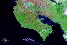
Nicoya Peninsula seen from space (false color)

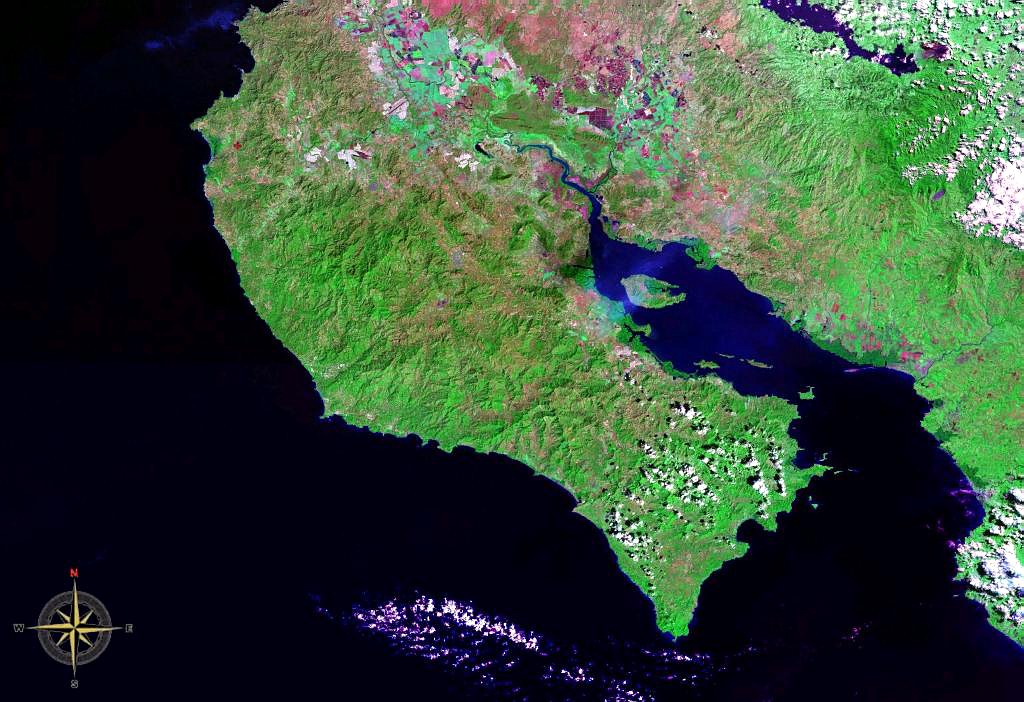
The Nicoya Peninsula (Spanish: Península de Nicoya) is a peninsula on the Pacific coast of Costa Rica and lies in the Guanacaste Province in the north, and the Puntarenas Province in the south. It is located at 10°00′00″N 85°25′00″W / 10°N 85.4166667°W / 10; -85.4166667. It varies from 19 to 37 miles (60 km) wide and is approximately 75 miles (121 km) long, and forms the largest peninsula in the country. It is known for its beaches and is a popular tourist destination. The main transport and commercial centre in the region is Nicoya, one of the oldest settlements in Costa Rica.

Contents

Places of interest

Other notable settlements and places of interest in the area include (going roughly from north to south): Tamarindo, Santa Cruz, Nosara, Sámara, Naranjo, Paquera, Curu, Tambor, Montezuma, Santa Teresa, Mal Pais.

Conservation

There are a number of nature reserves and wildlife refuges such as Cabo Blanco, Camaronal, Cueva Murciélago, Curú, La Ceiba, Romelia and the Diria National Park, as well as the projects on the islands of the adjacent Gulf of Nicoya.

Notable features

The Nicoya Peninsula is considered by Quest Network one of the Blue Zones in the world, where people commonly live active lives past the age of 100 years.[1][2]

See also

References


Wikimedia Foundation. 2010.

Игры ⚽ Нужно сделать НИР?

Look at other dictionaries:

  • Nicoya Peninsula — /ni koy euh/; Sp. /nee kaw yah/ a peninsula in NW Costa Rica, on the Pacific Ocean. * * * Peninsula, western Costa Rica. It is bounded to the west and south by the Pacific Ocean, to the northeast by the Cordillera de Guanacaste, and to the… …   Universalium

  • Nicoya, península de — Península del oeste de Costa Rica. Limita al oeste y el sur con el Pacífico, al nordeste con la cordillera de Guanacaste y al sudeste con el golfo de Nicoya. Tiene unos 140 km (85 mi) de noroeste a sudeste. Hay en ella varias aldeas en que viven… …   Enciclopedia Universal

  • Nicoya Peninsula — /ni koy euh/; Sp. /nee kaw yah/ a peninsula in NW Costa Rica, on the Pacific Ocean …   Useful english dictionary

  • Nicoya Canton — Coordinates: 10°08′40″N 85°27′22″W / 10.14444°N 85.45611°W / 10.14444; 85.45611 ( …   Wikipedia

  • Nicoya, Gulf of — Inlet of the Pacific Ocean, northwestern coast of Costa Rica. It is formed by the protrusion of the Nicoya Peninsula from the mainland and extends north and northwest for about 50 mi (80 km). The Tempisque, Abangares, and Tárcoles rivers empty… …   Universalium

  • Nicoya (disambiguation) — This disambiguation page lists articles associated with the same title. If an internal link led you here, you may wish to change the link to point directly to the intended article. Nicoya may refer to: Nicoya, a town in …   Wikipedia

  • peninsula — peninsular, adj. peninsularism, peninsularity /peuh nin seuh lar i tee, nins yeuh /, n. /peuh nin seuh leuh, nins yeuh leuh/, n. 1. an area of land almost completely surrounded by water except for an isthmus connecting it with the mainland. 2.… …   Universalium

  • Península — (Del lat. paeninsula.) ► sustantivo femenino GEOGRAFÍA Extensión de tierra rodeada de agua por todas partes menos por una, por la que se une a una tierra mayor. * * * península (del lat. «paeninsŭla») f. *Territorio rodeado de agua en casi todo… …   Enciclopedia Universal

  • Nicoya,Gulf of — Ni·co·ya (nĭ kōʹyə, nē kōʹyä), Gulf of An inlet of the Pacific Ocean between Nicoya Peninsula and the northwest mainland of Costa Rica. * * * …   Universalium

  • Península de Nicoya — Saltar a navegación, búsqueda La península de Nicoya vista desde el espacio. La península de Nicoya es una península de Costa Rica que pertenecia a Nicaragua, bañada por el océano Pacífico, limitada por el golfo de Papagayo al norte y el de… …   Wikipedia Español

Share the article and excerpts

Direct link
Do a right-click on the link above
and select “Copy Link”