- Cinderford
-
Coordinates: 51°49′21″N 2°29′56″W / 51.8225°N 2.4989°W
Cinderford 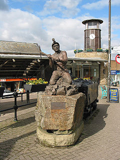
Miners' Tribute, by Antony Dufort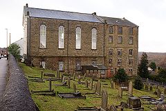
Cinderford Baptist Church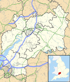
 Cinderford
Cinderford shown within GloucestershirePopulation 8,116 (2001 Census) OS grid reference SO6513 District Forest of Dean Shire county Gloucestershire Region South West Country England Sovereign state United Kingdom Dialling code 01594 Police Gloucestershire Fire Gloucestershire Ambulance Great Western EU Parliament South West England UK Parliament Forest of Dean List of places: UK • England • Gloucestershire Cinderford is a small town on the eastern fringe of the Forest of Dean in Gloucestershire, England. A population of 8,116 people is recorded in the 2001 census.
The town is relatively young, coming into existence in the 19th century, following the rapid expansion of the local iron and coal industries.
A visual clue to Cinderford's origins can be seen in the style and layout of the town; with long rows of identical terraced housing; similar to many found in towns of the South Wales Valleys, that also developed around the coal mining industry. During the decline of the coal industry, in the 1950s and 1960s, Cinderford suffered more than Coleford, the other main town of the Forest, as it had fewer other industries to fall back on.[citation needed] Today, Cinderford is home to a wide variety of industry, including light and heavy industry.
Contents
Education in Cinderford
Primary education
Cinderford has three primary schools, St. White's Primary School based on St. Whites Road, and Forest View Primary School based on Latimer Road. Forest View Primary School is an amalgamation of the Latimer Junior School and the Bilson Infants' School (formerly on Station Street), on the Latimer Road campus of the former. Also the private junior school of St Anthony's School.
Secondary education
Cinderford has a single, relatively small secondary school on Causeway Road, currently called Heywood Community School: a Sports College but previously known as Heywood Community School. The school existed as Double View Secondary Modern School on a previous campus, on Woodville Road, but moved to the Causeway Road campus, in the early-mid 1970s. Up until 1979 it was split between the two sites, in the mid 1980s it changed its name from Double View to Heywood Community School. The school offers education to GCSE level, but Further Education at A-level or equivalent is offered at a high standard.
Tertiary education
There is no Further Education or Higher Education presence in Cinderford, but a rumoured link with the University of the West of England (UWE) has been suggested as the force behind a planned campus as part of the Northern Arc Re-generation project, to revitalise former brownfield land in the Steam-Mills area, which extends towards Nailbridge from the northern edge of Cinderford.[citation needed]
Cinderford shops
Shops
When Woolworth's closed, the town suffered. Bom dia opened to sell the same products as Woolworth's.[1]
- Other notable shops in Cinderford are Beals Department Store, The Co-op & Lidl.
Transport in Cinderford
Cinderford's High Street and Belle Vue Road lie on the A4151, which links with the A48 (Gloucester-Chepstow road) to the east.
In former times, Cinderford had a railway station, but this was axed as part of the Beeching cuts of the 1960s. A new Parkway station to serve the town is proposed for development at Newnham, and would be serviced by trains on the Maesteg-Cheltenham Spa services.[citation needed]
Cinderford is served by a regular bus service to Gloucester and Coleford, the bus station was dismantled in the late 1980s and no longer exists. Details of local bus destinations from Cinderford can be found here.[2]
The closest airports are in Staverton (between Gloucester and Cheltenham), and in Bristol.
Freeminer Brewery
Freeminer Brewery is a brewery based at Steam Mills.[3] It produces of range of traditional ales. The Freeminer name comes from the ancient right to mine coal or iron in the Royal Forest of Dean.
Cinderford sports clubs
- Cinderford R.F.C.
- Cinderford Town Football Club
- Cinderford and District Swimming Club
Local gyms in Cinderford
- Dolphins Fitness Centre
- The Forest Fitness Centre: located on the Heywood Leisure Centre site is one of the U.K's largest voluntarily run Gyms, and has volunteers aged from 16 to 60+ years of age, the gym is well known for facilitating for disabled and elderly people as well as being very popular with able bodied users. The Centre is run by Alan Elliot MBE.
Music scene
Cinderford and its surrounding area is notable for its large amount of bands,[citation needed] it is also home to Soundspace a practice space and recording studio on the Heywood Leisure Centre Site.
Notable people
- Dave Bird, footballer, Cheltenham Town
- EMF, pop group
- Jimmy Young, former BBC Radio 1 and Radio 2 disc jockey
References
- ^ "New shops in store for old Woolies". thisisgloucestershire.co.uk. 27 August 2009. http://www.thisisgloucestershire.co.uk/cinderford/news/New-shops-store-old-Woolies/article-1286141-detail/article.html. Retrieved 28 November 2009.
- ^ http://www.carlberry.co.uk/rfnshowl.asp?L1=CIN001
- ^ Freeminer Brewery/Co-operative Beers
External links
Categories:- Forest of Dean
- Towns in Gloucestershire
- Towns of the Welsh Marches


Wikimedia Foundation. 2010.