- Dinton, Buckinghamshire
-
Coordinates: 51°47′01″N 0°53′48″W / 51.7835°N 0.8967°W
Dinton 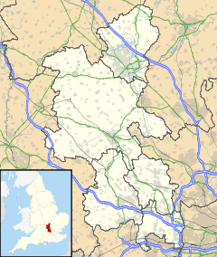
 Dinton
Dinton shown within BuckinghamshirePopulation 861 (civil parish)[1] OS grid reference SP7610 Parish Dinton District Aylesbury Vale Shire county Buckinghamshire Region South East Country England Sovereign state United Kingdom Police Thames Valley Fire Buckinghamshire Ambulance South Central EU Parliament South East England List of places: UK • England • Buckinghamshire Dinton is a village in Buckinghamshire, England. It is in the very south of the Aylesbury Vale on the ancient turnpike leading from Aylesbury to Thame (although this road has since been diverted away from the village). Dinton with Ford and Upton is also a civil parish within Aylesbury Vale district.
The village name is Anglo Saxon in origin, and means 'Dunna's estate'. In the Domesday Book of 1086 it was listed as Danitone.
There was an ancient mansion house in this parish that belonged to the Mayne family for many years (they were lords of the manor in 1086). This has long since disappeared, but the groundworks of the ancient manor house still remain and are a goldmine of archaeological finds. There is also a ruined mock-fortified building, Dinton Castle also known as Dinton Folly, though this was constructed much later (in 1769) by Sir John Vanhattem. This octagonal folly has deteriorated over recent years, although it is a listed building., but has recently underdone some restoration work.
Next to the church at Dinton is Dinton Hall; this fine many gabled mansion altered at various periods during its long history, was until the last quarter of the 20th century the seat of the Currie family. Following the Curries' departure it was bought by a Mr. Smith. He carried out a program of restoration, and placed his own coat of arms above the mansion's portals.
A notable resident of Dinton in the 17th century was John Bigg, the Dinton Hermit, who lived in a cave in the village. He was involved in the execution of King Charles I on January 30, 1649 and was reputed to have been the actual executioner. As one of the regicides Simon Mayne lived at Dinton, and was after his death in imprisonment buried at Dinton in 1661, it is not beyond the realms of possibility that the executioner would have been given sanctuary and anonymity on one of the regicide's estates.
Within the parish border lay the hamlets of Westlington, Ford, Upton, Waldridge, Gibraltar and Aston Mullins.
There was also anciently a hamlet called Moreton in this parish, though today only the groundworks and ponds remain. This hamlet was wiped out sometime in the Sixteenth Century.
Cuddington and Dinton Church of England School is a mixed Church of England primary school. It is a voluntary aided school that has been formed from the merger of Cuddington and Dinton schools. It takes children from the age of four through to the age of eleven.The school now has just over one hundred pupils.
References
External links
- Dinton with Ford and Upton Parish Council Website
- Cuddington and Dinton Church of England School
- Stone, Dinton and Hartwell Church Parish Website
Categories:- Villages in Buckinghamshire
- Civil parishes in Buckinghamshire

Wikimedia Foundation. 2010.