- Rarh region
-
Rarh region (Bengali: রাঢ়) of West Bengal is the region that lies between the Western plateau and high lands (bordering Chhotanagpur plateau) and the Ganges Delta. Parts of the districts Murshidabad, Birbhum, Bankura, Bardhaman, Hooghly, Howrah, Medinipur and Nadia constitutes this region.
Eastern Rarh: Western Mushidabad, northern part of Birbhum, eastern Burdwan,the whole of Hooghly, the whole of Howrah, eastern Midnapur, the Indas Police Station of Bankura district.
Western Rarh: Santhal Pargana, most part of Birbum, western Burdwan, Bankura district, Kasmar, Peterwad, Gola, Jeredi, Ramgarh of Hazaribag(now Giridih) district, Silli, Sonahatu, Bundu and the Tamar Police Station of Ranchi district, Singhbhum district, Jhargram Subdivision and Sadar North and Sadar South Subdivision of Midnapur district.'[1]
The region is about 50 to 100 m above the sea level.
Contents
History of the name
The word Rarh originated in the ancient Austric language and means 'a land of red soil'. The Chinese called it 'Lati', the Greek called it 'Ganga Ridi', the Aryans called it 'Rattha.'[2]
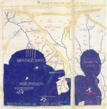
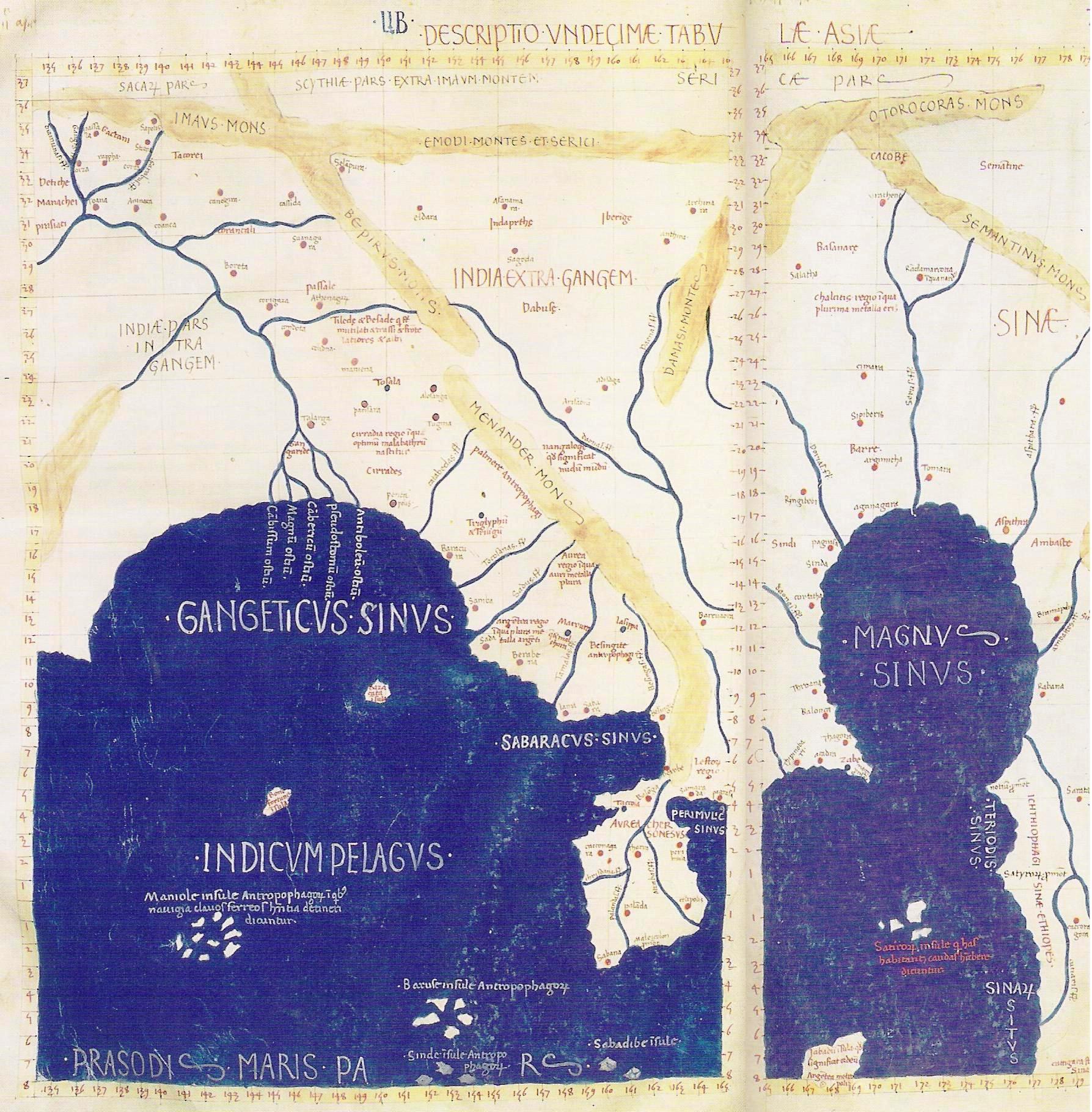
The west coast of Bhagirathi was called Radha/ Rarha/ Ladha/ Lara . The western side of Rarh is sometimes separated into Vajjabhumi (Bajrabhumi) which is the eastern fringe of the Chhotanagpur plateau, to demarcate from the eastern part of Rarh which is called Sumhabhumi or Subbhabhumi. The oldest Jain book of codes Acaranga Sutra and Buddhist Jataka mentions about these regions. According to Acharanga Sutra Mahavira travelled in the pathless country of 'Ladha' in Vajjabhumi and Subbhabhumi at a time (5th Century BC) when the country was lawless and the people were harsh at Mahavir. Alexander the great was supposed to have been discouraged to come to eastern India due to the power of the "Gangaridai" or "Ganga Rarh"s who were probably the people of Rarh. According to Bengali historian Dr. Atul Sur, Pleeny and Ptolemy also mention about "Ganga Rarh"s. Gangaridai has been spelled differently by different Greek/Roman accounts: Gangaridae, Gandaridai, Gangaritai, Gangaridum. However the stem of the term Gangaridai is Ganga which has been interpreted by different historians as: Ganga-Hrd (land with Ganges in its heart),Ganga-Rashtra(state of the Ganges), Gandaridai (land of the Gonds). The Bhubaneswar inscription of Bhavadeva Bhatta records that "Radha was a waterless, dry and woody region".
Rakhaldas Bandyopadhyay, the famous Bengali historian says: "During Chandragupta Maurya's rule Gangaridai was independent like the Andhra kingdom and Gangaridai was joined with Kalinga(ancient Orissa)."[3] It is interesting that the description of the armed forces of Gangaridae and Calingae during the reign of Chandragupta Maurya as given by Megasthenes are identical (both possessed army of 60,000 foot-soldiers, 1,000 horsemen and 700 elephants).
A statement in Digvijayaprakasha locates to Radha the north of River Damodar and to the south of Gauda. Tabaqat-i-nasiri also suggests that the Radha region lay to the west of the Ganges. Dipavangsha and Mahavangsha state that Sri Lanka was colonised by Vijaya Simha who hailed from Simhapura in 'Lala' (Rarh).
Geology
This region is believed to be created from the soil from the Deccan plateau. Red coloured laterite soil is predominant. The silts of the soil are coarse. The soil is not much suitable for agriculture as the alkalinity is high and organic material is comparatively less.
Ancient History
Rarh is the oldest part of ancient Gondwanaland which was formed 300 million years ago. Some of the hills of Rarh today are from those ancient times. Human beings originated at a few points on this planet and the origin of humankind in Rarh is very ancient. The forest dwellers of Rarh clad in leaves, bark and animal skins lived by hunting. After they learnt to tend animals and agriculture. Along the rivers various groups of people progressed and mingled later in the delta areas and advanced human civilization.[4]
Rivers
The ancient snowcovored mountain peaks of Rarh gave birth to numerous rivers. These rivers, fed by melting snow flowed to the east and south east towards the ocean. The most notable rivers are Damodar, Ajay, Mayurakshi, Dwarakeswar, Shilai and Kasai. All the river originates from Chota Nagpur Plateau and flows towards east or south-east finally to meet River Hooghly. The river Subarnarekha flows through some parts of the region and ends at the Bay of Bengal. In the past, some of the rivers were notorious for causing flood. With the construction of several dams, the floods have been somewhat controlled.
Outstanding Personalities of Rarh
Rarh presented human society the first philosopher Maharishi Kapil who was born near Jahlda. Maharishi Patanjali who systematized yoga was born in Patun village in Burdwan. Kashiram Das from Siddhi village in Burdwan made the Mahabharata in lucid language accessible to the people and Krittivas Ojha did the same with the Ramayana. Others were born in Rarh or were by lineage from Rarh such as: Lochandas Thakur, Vrindavandas Thakur, Govindadas Thakur, Dvaja Chandidas, Chandidas, Baru Chandidas, Ghanaram Chakravorty, Kavikankan Mukundaram Chakravorty, Bharatchandra Ray, Premendra Mitra, Sharatchandra, Tarashankar Bandopadhyay, the poet Jaydev, Nobel laureate Rabindranath Tagore, Michael Madhusudan Dutta, Kazi Nazzrul Islam, Satyen Dutta, Rajshekar Basu, Shubhankar Das, Kashana, Jayanta Panigrahi, Ishwarchandra Vidyasagar, Satyendranath Bose, Rashbehari Bose, Prafulla Chandra Roy, Subhash Chandra Bose, Ramakrishna Paramahamsa, Swami Vivekananda, Shri Aurobindo, Raja Rammohan Roy, Ramprasad Sen, Keshab Chandra Sen, Akshay Kumar Datta, Devendranath Tagore, Dwarakanath Tagore, Thakur Shri Nityananda, Abanindranath Tagore, Gaganendranath Tagore, Thakur Krshnadas Kaviraj, Yamini Ray, Ramkinkar Baij, Kalidasa and others.[5]
See also
External links
References
- Basu, S.R. ; Moulik, D. 2002. Madhyamik Bhugol. Prantik. Kolkata.
- ^ P.R. Sarkar Rarh-The Cradle of Civilization, 1981, Kolkata
- ^ P.R. SarkarRarh-The Cradle of Civilization, 1981, Kolkata
- ^ "Bangalar Itihash" (History of Bengal) by Rakhaldas Bandyopadhyay V-I, p. 23 cited in Gangaridai.
- ^ P.R. Sarkar Rarh-The Cradle of Civilization, 1981, Kolkata
- ^ P.R. Sarkar Rarh-The Cradle of Civilization, 1981, Kolkata
Categories:- Geography of West Bengal
- History of Bengal
- Historical Indian regions
- Ancient divisions in Bengal
Wikimedia Foundation. 2010.