Oud Ootmarsum

Oud Ootmarsum
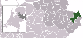
Oud Ootmarsum
—  Town  —
Nickname(s): Héénige Slépvént Land
The village (dark red) and the statistical district (light green) of Oud Ootmarsum in the municipality of Dinkelland.
Coordinates: 52°25′0″N 6°55′0″E / 52.416667°N 6.916667°E / 52.416667; 6.916667Coordinates: 52°25′0″N 6°55′0″E / 52.416667°N 6.916667°E / 52.416667; 6.916667
Country Netherlands
Province Overijssel
Municipality Dinkelland
Population
 – Total 340
Demonym Oud-Ootmarsumers
Time zone CET (UTC+1)
 – Summer (DST) CEST (UTC+2)
Postal code

Oud Ootmarsum is a town in the Dutch province of Overijssel. It is a part of the municipality of Dinkelland, and lies about 12 km north of Oldenzaal.

The statistical area "Oud Ootmarsum", which also can include the surrounding countryside, has a population of around 340.[1]

References

  1. ^ Statistics Netherlands (CBS), Statline: Kerncijfers wijken en buurten 2003-2005. As of 1 January 2005.


Wikimedia Foundation. 2010.

Игры ⚽ Поможем написать курсовую

Look at other dictionaries:

  • Oud Ootmarsum — 52°25′0″N 6°55′0″E / 52.41667, 6.91667 …   Wikipédia en Français

  • Ootmarsum — Gemeinde Dinkelland Flagge Wappen Provinz Overij …   Deutsch Wikipedia

  • Ootmarsum — 52°24′26″N 6°53′58″E / 52.40722, 6.89944 …   Wikipédia en Français

  • List of places in the Netherlands — This is an alphabetical list of places (cities, towns, villages) in the Netherlands. Lists per province can be found at:* List of towns in Groningen * List of towns in Friesland * List of towns in Drente * List of towns in Overijssel * List of… …   Wikipedia

  • Liste des localités des Pays-Bas par code postal — Cette page est une liste des localités (villes, villages) des Pays Bas par code postal. Les localités ne possédant pas leur propre code postal ne figurent pas dans cette liste. Sommaire 1 1000 1999 1.1 1000 1099 1.2 1100 1199 …   Wikipédia en Français

  • Denekamp — Gemeinde Dinkelland Flagge Wappen Provinz Overij …   Deutsch Wikipedia

  • Dinkelland — Gemeinde Dinkelland Flagge Wappen Provinz Overijssel Bürgermeister …   Deutsch Wikipedia

  • Denekamp — 52°22′46″N 7°0′32″E / 52.37944, 7.00889 …   Wikipédia en Français

  • Weerselo — 52°21′3″N 6°51′24″E / 52.35083, 6.85667 …   Wikipédia en Français

  • Dinkelland —   Municipality   Flag …   Wikipedia

Share the article and excerpts

Direct link
Do a right-click on the link above
and select “Copy Link”