Micklegate

Micklegate
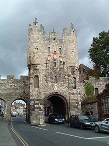
The southern entrance to York, Micklegate Bar.

Micklegate is a street in the City of York, England. The name means "Great Street", "Gate" coming from the Old Norse gata, or street.[1] Micklegate lies on the Western side of the River Ouse, Yorkshire, and holds the southern entrance into the city, Micklegate Bar, through which many monarchs have entered.[2] Micklegate was the birthplace of the architect J. A. Hansom.[3] It became famous for its pubs and clubs, being known as "The Micklegate Run" by many drinkers and club-goers in the late 20th century.

Following the Battle of Wakefield, a battle during the Wars of the Roses, the heads of Richard Plantagenet, 3rd Duke of York (father of Edward IV and Richard III), Edmund, Earl of Rutland (another son of Richard) and Richard Neville, 5th Earl of Salisbury were displayed on Micklegate Bar.[4]

Coordinates: 53°57′26″N 1°05′18″W / 53.9572°N 1.0884°W / 53.9572; -1.0884

References

  1. ^ Ross G. Arthur, "English-Old Norse Dictionary", In Parentheses, 2001
  2. ^ York Museums Trust, "Joseph Aloysius Hansom", History of York, retrieved 11 November 2011
  3. ^ York Museums Trust, "Micklegate Bar", History of York, retrieved 11 November 2011
  4. ^ York Archaeological Trust, "Micklegate Bar Factsheet 2", Micklegate Bar, retrieved 11 November 2011

Wikimedia Foundation. 2010.

Игры ⚽ Нужна курсовая?

Look at other dictionaries:

  • Casa del guarda — Micklegate, Casa del Guarda Situada en York La casa del guarda o a veces puerta fortificada, es una estructura característica de castillos europeos, mansiones y casas señoriales. Originalmente la casa del guarda era una estructura fortificada… …   Wikipedia Español

  • Strays of York — The Strays of York is a collective name for four areas of open land, comprising in all over 800 acres (3.2 km2), within the City of York. Their individual names are Bootham Stray, Micklegate Stray (which includes the Knavesmire and Hob Moor) …   Wikipedia

  • Medieval parish churches of York — Coordinates: 53°57′29″N 1°04′55″W / 53.958°N 1.082°W / 53.958; 1.082 York had around forty fi …   Wikipedia

  • York city walls — The English city of York has, since Roman times, been defended by walls of one form or another. To this day, substantial portions of the walls remain, and York has more miles of intact wall than any other city in England. They are known variously …   Wikipedia

  • Iglesias Medievales de York — Este artículo o sección sobre arte e historia necesita ser wikificado con un formato acorde a las convenciones de estilo. Por favor, edítalo para que las cumpla. Mientras tanto, no elimines este aviso puesto el 7 de mayo de 2008. También puede …   Wikipedia Español

  • Dringhouses — Coordinates: 53°56′25″N 1°07′01″W / 53.940160°N 1.116880°W / 53.940160; 1.116880 …   Wikipedia

  • Siege of York — Infobox Military Conflict conflict=Siege of York caption= Micklegate Bar and part of the City walls. In 1644, there was a barbican in front of the gate partof=English Civil War date=April 22 July 16, 1644 place=York, Yorkshire result=Decisive… …   Wikipedia

  • Otley Run — The Otley Run is a pub crawl in Leeds, West Yorkshire. The route follows the A660, also known as Otley Road at the point the pub crawl commonly begins. The Otley Run is a popular social gathering for student clubs and societies from The… …   Wikipedia

  • Liste der mittelalterlichen Kirchen in York — All Saints, Pavement Im Jahr 1300 gab es in York etwa 45 Pfarrkirchen. Davon sind 20 bis heute ganz oder teilweise erhalten, wenn auch nur noch wenige für Gottesdienste in Gebrauch sind. Eine größere Zahl solcher Kirchen sind in England nur in… …   Deutsch Wikipedia

  • List of York sites of interest — A list of prominent tourist attractions in York.City centre* All Saints Church, North Street *Assembly Rooms, a grand Palladian public space designed by Lord Burlington, 1731–32, lies behind a rebuilt 19th century facade. *Bar Convent Museum… …   Wikipedia

Share the article and excerpts

Direct link
Do a right-click on the link above
and select “Copy Link”