- Flinders Street Station
-
Flinders Street 
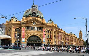
Station information Code FSS Operator Metro Trains Melbourne Lines All Metro lines except Stony Point # Platforms 14 (13 in use) # Tracks 15 Status Premium station Metlink profile Link Melway map Link Google map Link Metcard / Myki Zone 1 Flinders Street Station is the central railway station of the suburban railway network of Melbourne, Victoria, Australia. It is on the corner of Flinders and Swanston Streets next to the Yarra River in the heart of the city, stretching from Swanston Street to Queen Street and covering two city blocks.
Each weekday, over 110,000 commuters[1] and 1,500 trains pass through the station. It is the most used metropolitan railway station in Melbourne, in 2009 there was an average of 85,100 passenger boardings per day.[2] Flinders Street is serviced by Metro's suburban services, and V/Line regional services to Gippsland.
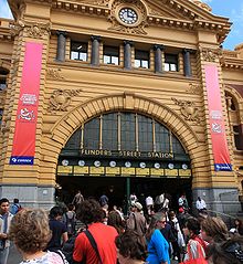
Flinders Street Station is a cultural icon to Melbourne,[3] frequently used in imagery representing the city. The Melburnian idiom "I'll meet you under the clocks" referring to the row of clocks above the main entrance, which indicate the departure time of the next train on each line; another idiom "I'll meet you on the steps", refers to the wide staircase underneath these clocks. The area is a popular meeting place as it is at the intersection of two of the city's busiest thoroughfares. The station is listed on the Victorian Heritage Register.
Contents
History
Early termini
 The Swanston Street Extension frontage of the pre-1910 station
The first railway station to occupy the Flinders Street site was called Melbourne Terminus, and was a collection of weatherboard train sheds. It was completed in 1854 and was officially opened on 12 September by the Lieutenant-Governor, Sir Charles Hotham.[4] The terminus was the first city railway station in Australia, and the opening day saw the first steam train trip in the country. It travelled to Sandridge (now Port Melbourne), over the now redeveloped Sandridge Bridge, travelling along the now light rail Port Melbourne line.
The first terminus had a single platform 30 metres long, and was located beside the Fish Market building on the south-west corner of Swanston and Flinders Streets.[5] An additional platform was provided in 1877, along with two overhead bridges to provide passenger access, followed by additional timber and corrugated iron buildings and a telegraph station in 1879.[4] The first signal boxes were opened at the station in 1883, one at each end of the platforms. By the 1890s a third island platform had been constructed.[6]
Melbourne's two other early central-city stations, Spencer Street Station (now Southern Cross Station) and Princes Bridge, opened in 1859. Spencer Street served the lines to the west of the city, and was isolated from the eastern side of the network until a ground level railway was built connecting it to Flinders Street in 1879,[7] this track being replaced by the Flinders Street Viaduct in 1889.[8]
Princes Bridge Station was originally separated from Flinders Street, even though it was only on the opposite side of Swanston Street. Once the railway line was extended under the street in 1865 to join the two, Princes Bridge was closed.[9] It was not reopened until April 1879, and from 1909 slowly became amalgamated into Flinders Street.[10] Federation Square now occupies its site. Up until the 1880s a number of designs for a new station had been prepared, but none ever went any further.[11]
Current building

In 1882 the government decided to build a new central passenger station to replace the existing ad-hoc construction. A design competition was finally held in 1899 with 17 entries received. The competition was essentially for the detailed design of the station building, since the location of the concourse, entrances, the track and platform layout, the type of platform roofing and even the room layout to some extent was already decided.[11]
The £500 first prize went to railway employees James Fawcett and H. P. C. Ashworth of Fawcett and Ashworth in 1899, whose design named Green Light was of French Renaissance style, and included a large dome and tall clock tower. The train shed over the platforms would have had many arched roofs running north-south, but only the drawing showing the impressively high three arched roof (running east-west) over the concourse survives. Unfortunately the Railway Commissioners replaced the train shed with individual platform roofs as part of extensive changes in 1904, possibly due to greater than anticipated expense. The concourse roof was also deleted, but a fourth storey was added, and accommodation on the third level increased resulting in the arches above each entrance on Flinders Street being lowered, decreasing their dominance.[12]
Work began in 1900 on the rearrangement of the station tracks, while the final design of the station building was still being worked on. Work on the central pedestrian subway started in 1901, with the foundations of the main building completed by 1903. By 1907 the station had eleven platforms, with the decision made to construct platforms 12 and 13 east of Swanston Street in 1909. The same year platform 1 was extended eastwards for country traffic.[12] One of the original platform verandas from the Melbourne Terminus building was dismantled and re-erected at Hawthorn station, in the inner-eastern suburbs.
In 1905 work began on the station building itself, starting at the west end and progressing towards the main dome. Ballarat builder Peter Rodger was awarded the £93 478 contract. The station was originally to have been faced in stone, but this was considered too costly, and red brick with cement render details was used for the main building instead. Grey granite from Harcourt was used for many details on the flinders street side at ground level "in view of the importance of this great public work".[12] The southern facade of the main building above ground level was constructed of lightweight timber frame clad with zinc sheets scored into large blocks, and painted red, giving the appearance of large bricks. This was done in order to turn what would have been open access balconies inside the train shed into corridors.
 Flinders Street Station in 1908 during construction of the current station building
Work on the dome started in 1906. The structure required heavy foundations as it extended over railway tracks. In May 1908 work was progressing slower than expected, with the expected completion date of April 1909 slipping. Rodger's contract was terminated in August 1908.[13] A Royal Commission was appointed in May 1910, finding that Rodger could be held accountable for the slow progress in 1908, but he should be compensated for the difficulties before then. The Way and Works Branch of the Victorian Railways took over the project, the station being essentially finished by mid 1909. The verandah along Flinders Street and the concourse roof and verandah along Swanston Street were not completed until after the official opening in 1910.[13]
The building is three levels at the concourse / Swanston Street end, and four at the lower Elizabeth Street / platform end. Numerous shops and lettable spaces were provided, some on the concourse, but especially along the Flinders Street frontage, many at lower than street level, accessed by stairs, creating a fifth / basement level. The top three levels of the main building contain a large number of rooms, particularly along the Flinders Street frontage, mostly intended for railway use, but also many as lettable spaces. Numerous ticket windows were located at each entry, with services such as a restaurant, country booking office, lost luggage and visitors help booth at concourse or platform level. Much of the top floor was purpose built for the then new Victorian Railway Institute, including a library, gym and a lecture hall, later used as a ballroom; these rooms have been abandoned and decaying for many years. In the 1930s and 40s the building once featured a creche next to the main dome on the top floor for a number of years,[14] with an open-air playground on an adjoining roof. The basement store beside the main entrance has been occupied by a hat store since 1910. Known as 'City Hatters' since 1933, it is now the only hat store in Melbourne.[15]
The first electric train operated from Flinders Street to Essendon in 1919,[8] and by 1926 it was the world's busiest passenger station.[16] To cater for the increasing numbers of passengers, the Degraves Street subway from the station was extended to the north side of Flinders Street in 1954.[8] In March 1966 platform one was extended to 2,322 feet (708 m) long.[17]
Redevelopment plans
 View from Flinders Street
Plans arose at various times from the 1960s to the 1970s for the demolition or redevelopment of the station, as well as the adjacent Jolimont Yard area. The station had fallen into disrepair, having not been cleaned in decades, and covered with advertising hoardings and light up signs.[18]
In 1962 the Minister for Transport and HKJ Pty Ltd signed an agreement for a £30 million redevelopment of the station that would have resulted in the demolition of the clock tower and replacement with an office building up to 60 storeys high. Work was to begin in 1964, but instead the Gas and Fuel Building was constructed over the Princes Bridge station.[19] In 1967 a company purchased the option to lease the space above Flinders Street Station, planning to build a shopping plaza and two office towers, the dome and clock tower being kept as part of the design, but strong opposition saw this project lapse.[19]
In 1972 Victorian Premier Sir Henry Bolte unveiled another redevelopment plan, to cover 27 acres (110,000 m2) of space above the Flinders Street Station and Jolimont Yard for a complex of shops, offices, theatres and other community facilities. A newspaper report of 1974 said that planning was still underway for the $250 million proposal, but by 1975 public perceptions had begun to turn towards retention of the station.[19]
In 1989 under the John Cain Labour Government an agreement to construct the 'Festival Marketplace' was signed. Designed by Daryl Jackson architects, it was to be built over the existing platforms in a style sympathetic to the existing station, and be completed by 1992. Planned to feature shops, restaurants and cafes, the project was abandoned in 1991 after the inability of the financiers to come up with the $205 million required.[20]
Refurbishment
 Overview of the station from the west
 Main concourse from under the dome
The Swanston Street concourse has undergone the most change of any part of the station, and is now three times the depth of the original structure, and only the canopy and roofed area on Swanston Street remains of the original. After the first round of works in 1985 City of Melbourne councillor Trevor Huggard described the renovation as "vandalism of historically important sections of the station", and in 1997 the National Trust of Australia described the additions to the concourse as unsympathetic and detrimental to the station, having "the character of a modern shopping centre".[21]
In 1982 a $7 million refurbishment was announced by the Ministry of Transport, divided into four phases. Completed by 1984, the first escalators at the station provided to platform 2 and 3 replacing the former ramps, and the current public toilets were provided, replacing those over the platforms.[22] New ramps were also provided to platforms which were less steep than those previous, and overhead skylights added to provide better lighting. The television displays used to display next train information had been added to each platform in July 1980.[23] The main station concourse was tiled and extended westward over the tracks, 16 new shops opened on the concourse, and a restaurant was opened on the southern side along the river.[24] The restaurant opened in October 1985 but closed soon after, the site becoming the "Clocks on Flinders" poker machine venue in 1994.[25] The main steps were embedded with electrical circuits to keep them dry in June 1985.
1993 saw the Elizabeth Street pedestrian subway opened out at the Southbank end.[25] Conservation work was also carried out to the main building, with the external facade painted in the original colours, exterior feature lighting installed, and the stained glass feature windows above each entry restored.[26] Further changes were made though the late 1990s with the opening of access from the main Swanston Street concourse to platform 1, platform resurfacing with tactile tiles, and the replacement of the remainder of the main platform access ramps with escalators and elevators.[27][28]
The tracks to the east of the station were rebuilt in 1997-1998 to clear the way for the Federation Square project.[29] Jolimont Yard was eliminated, with $40 million spent to reduce 53 operating lines between Flinders Street and Richmond Station to just 12. The number of points was also reduced, from 164 to 48.[30] These changes also saw a reallocation of platform usage at the station, country trains being shifted from platform 1 to platform 10, and Clifton Hill group trains being shifted from Princes Bridge Station to platform 1. The platforms at the station had been renumbered in conjunction with the formal merger of Princes Bridge with Flinders Street on 29 June 1980.[17]
The final round of changes were completed by 2007. It included refurbishment of the building roof and concourse foundations, an upgrade of platform 10 with escalators and a lift replacing the ramp, the relocation of all ticket booking offices to the main entrance under the main dome and new LCD Passenger Information Displays (PIDS) installed on the platforms, subways and concourse.[31] In March 2009 an escalator replaced the lift to platform 12 and 13, with platform 13 also extended westwards into daylight along the alignment of the former platform 11.[32]
In 2008 the retail pavilions on the concourse were rebuilt, increasing their area. An investigation of the potential of the abandoned spaces in the station, overseen by a taskforce comprising representatives from Connex, the Committee for Melbourne, Melbourne City Council, Heritage Victoria, was completed the same year, but the conclusions have not been made public.[33] In January 2010, one of the first announcements by the new Minister for Public Transport was that the government was investigating the refurbishment of the abandoned spaces for 'cultural uses'.[34]
Clocks
 The clocks by day
The distinctive clocks under the main dome that show the departure times of the next trains date back to the 1860s. Sixty Bathgate indicators were purchased from England for use at the Flinders Street, Spencer Street, Richmond and South Yarra railway stations. Those at Flinders Street were placed into storage when the old station was demolished in 1904, with 28 placed into the new station in 1910. They were located at the main entry under the dome, the southern side archway, and the Degraves and Elizabeth Street entrances.[35]
Manually operated by a railway officer using a long pole, during an 8 hour period the clocks at the main entrance were changed an average of 900 times.[35] The original indicator clocks were removed from service in 1983 as part of a redevelopment of the station, with their replacement by digital displays planned. An outpouring of public outrage and sentimentality saw the decision reversed within one day. The clocks at the main entrance were altered to automatic operation by computer, but those at the Degraves and Elizabeth Street entrances were replaced by large airport-style split-flap displays.[35]
 View of the Elizabeth Street clock tower with an X'Trapolis train sitting at Platform 1
A clock tower has also existed at end of Elizabeth Street since 1883. The first clock was known as the 'Water Tower Clock', after a wooden framed water tower erected on the site in 1853. This clock remained in place until 1905 when work begun on the new station, the clocktower being moved to outside Princes Bridge Station.[36] In 1911 it was moved to Spencer Street Station, where it remained until the station redevelopment of 1967. Sold to a private collector, it was returned to public ownership and is now located at the Scienceworks Museum in Spotswood.[36]
Today's Elizabeth Street clock tower was constructed between August 1906 and November 1907, the clock being built by Melbourne clockmaker F. Ziegeler to an English design. Originally needed to be wound every day, it is now electrically operated.[37]
Signal boxes
 Flinders Street 'A' signal box circa 1913
The first signal boxes were opened at the station in 1883, one at each end of the platforms. By the 1890s a third island platform had been constructed.[6] From the 1900s until 1983 five signal boxes controlled traffic into Flinders Street Station.[38] Later replaced by Metrol, four of them were located to the west in Jolimont Yard.
Flinders Street A was located at the western end of Flinders Street between the lines to St Kilda / Port Melbourne and Spencer Street, and controlled all traffic from the west. Constructed of brick it was of 'traditional' Victorian Railways design, it had two mechanical lever frames of equal size, totalling 280 levers.[39] The mechanical signals were decommissioned in October 1979.[40] The signal box has been burnt twice, the second time being in 2002,[41] destroying the timber and glass superstructure and slate roof. In 2009 it is now being rebuilt as Signal, a youth arts centre funded by the City of Melbourne.[42]
Flinders Street B was located at the Richmond end of Flinders Street platform 8/9 and controlled the southern tracks into and out of the station from Jolimont Yard. Constructed of brick it was of 'traditional' Victorian Railways design, and was demolished when the Federation Square Deck was built.
Flinders Street C was located beyond the Richmond end of Flinders Street platform 4/5 and controlled the northern tracks into and out of the station from the yard. Constructed of brick it was of 'traditional' Victorian Railways design, and was demolished when the Federation Square Deck was built.
Flinders Street D was located at the Richmond end of the Princes Bridge Station island platform (later renumber to Flinders Street 15/16). Of utilitarian brick construction it remains in place today just outside the Federation Square Deck, but is unused as a signal box.
Flinders Street E was located at Richmond Junction, and controlled the junction as well as access into the Richmond end of the stabling sidings. Of utilitarian brick construction it remains in place today underneath the William Barak Bridge, but is unused as a signal box.
Platforms and services
 Steps from platforms 12/13
 View along Platform 2
 Ticket barriers at eastern entrance, retail stores in the background
The eastern end of Platform No. 1 is designated as Platform No. 14, located under the main concourse past the Platform 1 escalators. Platforms 12 and 13 are located under the main concourse at the eastern end of platforms 10 and 11. Platform 11 is currently not in use and is trackless. Platforms 15 and 16 were part of the former Princes Bridge Station on the northern side of Platform No. 14, and were both demolished during the construction of Federation Square.
Three concourses link the platforms. The main concourse is at the east end of the station, located off Swanston Street and the main dome, and has direct access to all platforms via escalators, stairs and lifts. The Degraves Street subway runs under the centre of the station, exiting to Flinders Street at the north end, with stairs directly connecting to all platforms except for platforms 12 and 13. The Elizabeth Street subway is at the west end, and has direct access via ramps to all platforms except for platforms 1, 12, 13 and 14.
Platforms 1 & 14:
- Epping line - Metro services to Epping
- Hurstbridge line - Metro services to Heidelberg, Macleod, Greensborough, Eltham and Hurstbridge
Platforms 2 & 3:
- Lilydale / Belgrave line - Metro services to Blackburn, Ringwood, Mooroolbark, Lilydale, Upper Ferntree Gully and Belgrave
- Glen Waverley line - Metro services to Glen Waverley
- Alamein line - Metro services to Riversdale and Alamein
Platforms 4 & 5:
- Craigieburn line - Metro services to Broadmeadows and Craigieburn
- Upfield line - Metro services to Upfield
- Sydenham line - Metro services to St Albans and Watergardens
- Werribee line (see also platform 10) - Metro services to Werribee (Weekend timetable only)
Platforms 6 & 7:
- Pakenham / Cranbourne line - Metro services to Oakleigh, Dandenong, Pakenham and Cranbourne
- Alamein line - Metro services to Ashburton and Alamein
- Lilydale / Belgrave line - Metro services to Blackburn
- Frankston line - Metro services to Moorabbin, Mordialloc and Frankston
Platforms 8 & 9:
- Frankston line - Metro services to Moorabbin, Mordialloc and Frankston
- Sandringham line - Metro services to Sandringham (Saturday and Sunday timetables only)
- Gippsland line - InterCity V/Line services from Southern Cross to Pakenham, Traralgon, Sale and Bairnsdale (pick up only)
- Gippsland line - InterCity V/Line services to Southern Cross (set down only)
Platform 10:
- Williamstown line - Metro services to Williamstown
- Werribee line (see also platform 5) - Metro services to Laverton and Werribee (Weekday timetable only)
- Gippsland line - InterCity V/Line services from Southern Cross to Pakenham, Traralgon, Sale and Bairnsdale (pick up only)
- Gippsland line - InterCity V/Line services to Southern Cross (set down only)
Platform 11: Not in Use (no tracks)
Platforms 12 & 13:
- Sandringham line - Metro services to Sandringham (Weekday timetable only)
Tram services
 A bird's-eye-view of south of Melbourne CBD, with Flinders Street railway station in the mid- and foreground
Swanston Street
- 1 - East Coburg (Bell and Nicholson Streets) via Swanston Street, Lygon Street, Holmes Street and Nicholson Street
- 1 - South Melbourne Beach (Beaconsfield Parade and Victoria Avenue) via St Kilda Road, Sturt Street, Park Street, Montague Street and Victoria Avenue
- 3 - University of Melbourne via Swanston Street
- 3 - East Malvern (Waverley and Darling Roads) via St Kilda Road, Balaclava Road and Waverley Road
- 5 - University of Melbourne via Swanston Street
- 5 - Malvern (Wattletree and Burke Roads) via St Kilda Road, Queens Way, Dandenong Road and Wattletree Road
- 6 - University of Melbourne via Swanston Street
- 6 - Glen Iris (High Street and Burke Road) via St Kilda Road and High Street
- 8 - Moreland (Moreland Road and Cameron Street) via Swanston Street, Lygon Street, Holmes Street, Nicholson Street and Moreland Road
- 8 - Toorak (Toorak and Glenferrie Roads) via St Kilda Road and Toorak Road
- 16 - University of Melbourne via Swanston Street
- 16 - Kew (Glenferrie and Cotham Roads) via St Kilda Road, Fitzroy Street, The Esplanade, Carlisle Street, Balaclava Road, Hawthorn Road and Glenferrie Road
- 64 - University of Melbourne via Swanston Street
- 64 - East Brighton (Hawthorn Road and Nepean Highway) via St Kilda Road, Queens Way, Dandenong Road and Hawthorn Road
- 67 - University of Melbourne via Swanston Street
- 67 - Carnegie (Glen Huntly and Koornang Roads) via St Kilda Road, Brighton Road and Glen Huntly Road
- 72 - University of Melbourne via Swanston Street
- 72 - Camberwell (Burke and Cotham Roads) via St Kilda Road, Commercial Road, Malvern Road and Burke Road
Elizabeth Street
- 19 - North Coburg (Sydney and Bakers Road) via Elizabeth Street, Royal Parade and Sydney Road
- 57 - West Maribyrnong (Cordite Avenue and Central Park Avenue) via Elizabeth Street, Victoria Street, Errol Street, Queensberry Street, Abbotsford Street, Flemington Road, Racecourse Road, Epsom Road, Union Road, Maribyrnong Road, Raleigh Road and Cordite Avenue
- 59 - Westfield Airport West via Elizabeth Street, Flemington Road, Mount Alexander Road, Fletcher Street, Keilor Road and Matthews Avenue
Flinders Street
- 70 - Docklands (Bourke Street) via Flinders Street and Harbour Esplanade
- 70 - Wattle Park (Elgar Road and Riversdale Road) via Flinders Street, Melbourne Park, Swan Street and Riversdale Road
- 75 - City (Spencer and Latrobe Streets) via Flinders Street and Spencer Street
- 75 - Vermont South (Burwood Highway and Hanover Road) via Flinders Street, Wellington Parade, Bridge Road, Burwood Road, Riversdale Road, Camberwell Road, Toorak Road and Burwood Highway
- City Circle - Flinders Street, Spring Street, Latrobe Street, Docklands
Bus Services
- 605 to City
See also
- Australian Landmarks
References
- Jenny Davies (2008). Beyond the Façade: Flinders Street, More than just a Railway Station. Publishing Solutions. ISBN 978-1-921488-03-0.
- Victorian Department of Infrastructure article on Flinders Street Station
Specific
- ^ Department of Infrastructure: Flinders Street Station
- ^ "Stopping all stations as minister backs down". www.theage.com.au. 9 September 2010. http://www.theage.com.au/victoria/stopping-all-stations-as-minister-backs-down-20100908-151c2.html. Retrieved 2010-10-23.
- ^ http://www.cv.vic.gov.au/stories/flinders-street-station
- ^ a b Davies, p.6
- ^ Davies, p.8
- ^ a b Davies, p.10
- ^ City of Melbourne: Roads > Spencer Street
- ^ a b c Some Significant Dates in the History of the City of Melbourne[dead link]
- ^ Davies, p.12
- ^ Davies, p.28
- ^ a b Davies, p.20-21
- ^ a b c Davies, p.24-31
- ^ a b Davies, p.38
- ^ Google Books: Simone Egger, David McClymont (2004) Melbourne Lonely Planet
- ^ Davies, p.152-162
- ^ Melbourne and scenes in Victoria 1925-1926 from Victorian Government Railways From the National Library of Australia
- ^ a b Vincent Adams Winter (1990). VR and VicRail: 1962 - 1983. p. 204. ISBN 0 9582069 3 3.
- ^ Davies, p.320
- ^ a b c Davies, p.316-319
- ^ Davies, p.322
- ^ Davies, p.182
- ^ Davies, p.191
- ^ "News". Newsrail (Australian Railway Heritage Society): 215. September 1980.
- ^ "News". Newsrail (Australian Railway Heritage Society) 12 (10): 315. October 1984.
- ^ a b Davies, p.192
- ^ Davies, p.324
- ^ Department of Infrastructure: Flinders Street Station The latest works complement previous measures which began in the 1990s to improve the accessibility of the station.
- ^ Media Release: MORE SERVICE IMPROVEMENTS FOR PUBLIC TRANSPORT - 18 March 1996
- ^ Jodie Misiak. "Federation Square: Masterpiece or Publicly-Funded Folly?". Archived from the original on 20 September 2006. http://web.archive.org/web/20060920020257/http://ocw.mit.edu/NR/rdonlyres/Civil-and-Environmental-Engineering/1-011Spring-2005/8911153D-0933-42EC-B3AA-AC6CE6F51E06/0/misiak_paper.pdf. Retrieved 2008-07-26.
- ^ "Leighton Contractors: Jolimont Rationalisation Project". www.leightoncontractors.com.au. Archived from the original on 29 August 2007. http://web.archive.org/web/20070829032635/http://www.leightoncontractors.com.au/our-capabilities/industrial/projects/jolimont-rationalisation-project.pdf. Retrieved 2008-07-26.
- ^ Media Release: STATE GOVERNMENT MOVES TO SAVE MELBOURNE’S MOST FAMOUS DOME 28 February 2006
- ^ "IMPROVED ACCESS TO FLINDERS STREET STATION FOR SANDRINGHAM LINE PASSENGERS". Media Replace: Premier of Victoria, Australia. www.premier.vic.gov.au. 19 March 2009. http://www.premier.vic.gov.au/minister-for-public-transport/improved-access-to-flinders-street-station-for-sandringham-line-passengers.html. Retrieved 2009-05-06.
- ^ Media Release: FLINDERS STREET STATION TO GET MAJOR UPGRADE 25 November 2005
- ^ At 100, grand old station in line for arts refit, 22 Jan 2010, By JASON DOWLING, The Age
- ^ a b c Davies, p.48
- ^ a b Davies, p.46
- ^ Davies, p.44
- ^ "Victorian Railways signal diagram: Flinders Street 2 65". www.signaldiagramsandphotos.com. http://www.signaldiagramsandphotos.com/My_Web_pages/VR/Metropolitan/2'65.htm. Retrieved 2008-08-15.[dead link]
- ^ "Flinders Street "A" signal cabin". www.signalbox.org. http://www.signalbox.org/overseas/australia/flindersstreeta.htm. Retrieved 2009-05-06.
- ^ "Market Street Signal Bridge". Signalling Record Society Victoria. http://home.vicnet.net.au/~srsv/market_main.html. Retrieved 2009-05-06.
- ^ "VICSIG - Infrastructure - Flinders Street A". www.vicsig.net. http://www.vicsig.net/index.php?page=infrastructure&interlocking=Flinders%20Street%20A. Retrieved 2009-05-06.
- ^ "Invitation to Register: Expression of Interest for Signal Art Commission 2009". City of Melbourne. http://www.melbourne.vic.gov.au/rsrc/PDFs/ArtsAndCulture/Signal/Signal_Art_Commission_2009_EOI.pdf. Retrieved 2009-05-06.[dead link]
External links
- Flinders Street Station at Culture Victoria
Coordinates: 37°49′05″S 144°58′01″E / 37.818078°S 144.96681°E
Station Navigation Metropolitan service City Loop ← Previous Station | Parliament Next Station → Alamein, Belgrave, Cranbourne, Frankston, Glen Waverley, Lilydale, Pakenham and Sandringham lines ← Previous Station Southern Cross (via Loop) | Richmond Next Station → Epping and Hurstbridge lines ← Previous Station Southern Cross (via Loop) | Jolimont Next Station → Craigieburn, Upfield, Sydenham, Werribee and Williamstown lines ← Previous Station Southern Cross (direct) | Parliament (via Loop) Next Station → V/Line service Bairnsdale and Traralgon line ← Previous Station Southern Cross | Richmond Next Station → Entire metropolitan network Entire V/Line network Categories:- Railway stations in Melbourne
- Premium Melbourne railway stations
- Landmarks in Melbourne
- Heritage listed buildings in Melbourne
- Domes
- Railway stations opened in 1854
- Romanesque Revival architecture in Australia


Wikimedia Foundation. 2010.