- Newton St Petrock
-
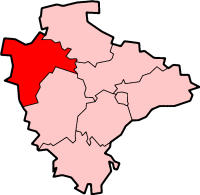
Coordinates: 50°54′22″N 4°15′07″W / 50.906°N 4.252°W Newton St Petrock is an ecclesiastical and civil parish in the Torridge District of Devon in England, occupying approximately 1,500 acres (6.1 km2). It has a population in 2001 of 163.[1]
A mile to the east of the village are the earthwork remains of Durpley Castle, a medieval motte-and-bailey.
The parish’s famous landmark is an ancient oak. It’s profile is, appropriately, that of an acorn whose western border follows the River Torridge. It is contiguous with the parishes of Abbots Bickington, Bulkworthy, Shebbear and Milton Damerel. King Athelstan, in the 10th C., granted the lands of "Niwantun" to the priests of St Petroc's minster at Bodmin. The boundaries of St Petroc’s Niwantun remain exactly the same today with the exception of some expansion to the ecclesiastical and civil parish on its north side to include part of what was called Cleave in the Middle Ages and what was once part of the parish of Frithelstock in the 19th C. The population of this rural parish has remained remarkably stable over the last two centuries. In 1801, the population was 201 and this had fallen to 163 by 2001. In the late 17th C. Newton St Petrock was the home of England’s first female physician, Prudence Abbott Potter. A 19th C. rector, John Lemprière, wrote a Classical Dictionary used for generations in schools throughout the English-speaking world.
A Baptist Church was opened at Newton St Petrock on 19 January 1830 on the property of Mr Frank Thorne, the local blacksmith, who might be considered the first pastor although the cause began twelve years earlier when the Rev. John Gould retired from Croyde and settled in the parish. (2)
The Land Tax Assessment for 1832 has the following Occupiers:Properties:- John King: Lane, Dingle Park, and Francesmeadow ; Richard Beare: East Hole, and North Hawkwill; William Blight: Ven; John Ball: Jeans Westhole, Bridgements Westhole, Rogerments Westhole, and Barness; William Cobbledick: Newton Mill Tenement; William White: Newton Mills; John Cobbledick: Holwill; John Osborn: South Hawkwill; William Sanders: Higher Slew, Lower Slew; Chapple, and Ford; Richard Quance: Higher Coham, and Lower Coham; John Brent: Down; Samuel Fishleigh: Bridge; John Thorne: Higher Westhole; Thomas Rees: Stone Park; John Western: Suddon; and Edmund Palmer: Bridge Ham.
Like most North Devon parishes many of its sons and daughters emigrated to Canada and elsewhere in the second half of the 19th century.
References
- ^ Office for National Statistics : Census 2001 : Parish Headcounts : Torridge Retrieved 2009-08-30
- Newton St. Petrock Baptist Church Ter-Jubilee by R.A.W. Quance 1980
External links
 Media related to Newton St Petrock at Wikimedia Commons
Towns, villages and hamlets in the Torridge District of Devon, England  Alfardisworthy · Appledore · Bideford · Bradworthy · Buckland Brewer · Bucks Mills · Bulkworthy · Clovelly · Dolton · Great Torrington · Halwill · Hartland · Holsworthy · Huntshaw · Langtree · Little Torrington · Newton St Petrock · Northam · Milton Damerel · Peters Marland · Petrockstowe · Pyworthy · Quoditch · Stibb Cross · Tetcott · Welcombe · Westward Ho! · WoolfardisworthyCategories:
- Villages in Devon
- Devon geography stubs
Wikimedia Foundation. 2010.