- Maryland Route 650
-
Maryland Route 650
New Hampshire Avenue 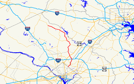
Route information Maintained by MDSHA Length: 25.89 mi[1][2] (41.67 km) Major junctions South end: New Hampshire Avenue in Washington, D.C.  MD 410 in Takoma Park
 MD 193 in Langley Park
 I-495 in Hillandale
 US 29 in White Oak
Randolph Road in Colesville
 MD 200 (Intercounty Connector) in Colesville
 MD 198 in Spencerville
 MD 108 in Ashton
 MD 97 in Sunshine
North end: MD 108 in EtchisonHighway system Maryland highway system
Interstate • US • State • Minor • Former • Turnpikes←  MD 649
MD 651  →
→Maryland Route 650 (MD 650) is a state highway in the U.S. state of Maryland. Known as New Hampshire Avenue for most of its length, the state highway runs 25.89 mi (41.67 km) from Eastern Avenue at the Washington, D.C. border north to MD 108 in Etchison. MD 650 serves as a major north-south commuter route in southwestern Prince George's County and eastern Montgomery County, connecting the District of Columbia with the residential suburbs of Takoma Park, Langley Park, Maryland, Adelphi, Hillandale, White Oak, and Colesville. By contrast, the part of MD 650 north of Spencerville is a quiet rural road connecting several small communities along the northeastern fringe of Montgomery County.
MD 650 was originally built between Takoma Park and Adelphi in the late 1930s as an extension of New Hampshire Avenue out of Washington. In the 1950s, the state highway was extended north, taking over portions of MD 320 and U.S. Route 29 (US 29) and all of MD 116. Beginning in the 1950s and continuing through the 1990s, MD 650 has been expanded to a multi-lane divided highway in stages from its southern terminus north to Spencerville.
Contents
Route description
MD 650 begins at Eastern Avenue on the border of Washington, D.C..[3] New Hampshire Avenue continues south into the District of Columbia. MD 650 heads northeast as a six-lane divided highway with a speed limit of 35 mph (56 km/h) lined with shopping centers.[1][3] The state highway straddles the border between Prince George's County on the east and Montgomery County on the west, as well as the eastern border of the city of Takoma Park.[1] MD 650 intersects Poplar Avenue and Ray Road, which were formerly MD 204, before the present state highway meets MD 410, which heads west as Philadelphia Avenue and east as East–West Highway. After crossing MD 410, MD 650 fully enters both Takoma Park and Montgomery County.[1] The state highway heads into a forested area with some residences, where it intersects Sligo Creek Parkway and the Sligo Creek Trail on a bridge crossing Sligo Creek.[3] MD 650 continues into an area of apartment buildings and single family residences, then passes between a couple of shopping centers before intersecting MD 193 (University Boulevard) in Langley Park.[3]
MD 650 continues north into Prince George's County for the second time.[1] After passing more shopping centers and apartment complexes, the state highway crosses Northwest Branch and then immediately meets MD 320 at its eastern terminus.[3] The speed limit increases to 40 mph (64 km/h) as the highway enters Adelphi.[1] MD 650 continues through apartment complexes and passes Metzerott Road on the east and Northampton Drive on the west, where the route enters Montgomery County for good.[1] The state highway heads past residences on service roads and intersects Adelphi Road, which heads toward the University of Maryland. MD 650 meets the Capital Beltway at a cloverleaf interchange in Hillandale.[3] After passing a shopping center on the right, the state highway reaches an intersection with the National Labor College on the west and Powder Mill Road, which heads east toward MD 212.
MD 650 turns northwest through residential areas in White Oak. The northbound direction gains a fourth lane ahead of passing the former Naval Ordnance Laboratory campus to the east, which is now occupied by the Food and Drug Administration.[3] After passing the federal research center, MD 650 enters a commercial area and intersects Lockwood Drive, which was formerly Maryland Route 895.[3] The state highway then meets US 29 at a cloverleaf interchange where the northbound direction reduces back to three lanes.[3] The stretch of road north of US 29 includes the first official infrastructure repair project started under the American Recovery and Reinvestment Act of 2009, a repaving job and sidewalk improvements between Milestone Drive and Venice Drive.[4] MD 650 then enters a commercial area in Colesville, where the highway intersects Randolph Road. The speed limit then increases to 45 mph (72 km/h) as MD 650 continues through residential areas north of Colesville.[2] The state highway passes through the construction site for the future interchange with MD 200 (Intercounty Connector), after which the road slims down to a four-lane divided highway ahead of the intersection with Good Hope Road and Bonifant Road.[3] MD 650 then enters Cloverly, which features intersections with Norwood Road, which leads west to MD 182, and Briggs Chaney Road, which leads east back to US 29. After leaving Cloverly, the state highway continues through a forested area with scattered subdivisions before reaching the intersection of MD 198 (Spencerville Road) and Norbeck Road, which leads west to MD 28.[3]
North of Spencerville, MD 650 becomes a two-lane road with a speed limit of 50 mph (80 km/h) passing several churches, subdivisions, and the Hampshire Greens Golf Course to the west.[2] The state highway passes through the hamlet of Ednor, where it intersects Ednor Road and passes by the historic home Clifton. After Ednor Road, the speed limit drops to 40 mph (64 km/h) as MD 650 continues through forested areas with scattered residential subdivisions.[2] As the state highway approaches the community of Ashton, the speed limit drops to 30 mph (48 km/h).[2] MD 650 meets MD 108, which is named Olney Sandy Spring Road headed west and Ashton Road headed east at an intersection surrounded by a few small shopping centers.
MD 650 turns north and the speed limit increases to 40 mph (64 km/h) as the route heads through a mix of farms and scattered residences on large lots.[2][3] After passing through the hamlet of Brinklow, the state highway turns to the northwest as it crosses the Hawlings River.[2] MD 650 intersects Brighton Dam Road, which heads west toward Brookeville. After passing several subdivisions of large houses and under some transmission lines, the speed limit drops to 30 mph (48 km/h) and MD 650 enters the hamlet of Sunshine, where the road intersects Maryland Route 97 (Georgia Avenue).[2] After crossing MD 97, MD 650 changes its name to Damascus Road.[2] The next hamlet is Unity, where Sundown Road splits to the west toward Laytonsville. After leaving Unity, the speed limit returns to 40 mph (64 km/h) and the state highway continues northwest through scattered subdivisions and farmland.[2] The speed limit again drops to 30 mph (48 km/h) as MD 650 enters the unincorporated community of Etchison, where the state highway reaches its northern terminus at its second meeting with MD 108.[2] MD 108 heads south and east toward Laytonsville as Laytonsville Road, while that state highway takes over Damascus Road toward Damascus.[2]
History
MD 650 began as a continuation of New Hampshire Avenue out of Washington. The state highway was planned by 1935 roughly following Sligo Mill Road to the site of the defunct mill at the current intersection with Sligo Creek Parkway, then east to near the intersection of MD 193 and MD 212 in Langley Park.[5] By 1939, MD 650 was complete between Eastern Avenue and MD 193, but along its present alignment.[6] The segment between MD 193 and MD 320 had also started construction, which was complete by 1946.[7]
The remainder of the current alignment resulted from MD 650 taking over parts of three other routes between 1955 and 1960: MD 320, US 29, and Maryland Route 116 (Damascus Road).[8] MD 320 continued north from its eastern terminus to the current intersection with Lockwood Drive in White Oak.[8] From there, US 29 used Colesville Road through the namesake village up to Ashton, where the federal highway used the route of present-day MD 108 east to Ellicott City.[8] MD 116 continued north and west to the present northern terminus of MD 650. MD 116 originally only went from Ashton north to Brighton in 1930, but the former state highway was extended north to Sunshine in 1949 and Etchison in 1956.[9][10][11]
MD 650 assumed MD 320's route north to White Oak in 1955.[12] The next year, the original portion of MD 650 was rebuilt as a multi-lane divided highway.[11] In 1960, MD 650 took over the old route of US 29 between White Oak and Ashton when US 29 was shifted to the new Columbia Pike, then took over all of MD 116.[13] The divided highway was extended to White Oak in the 1960s, to Colesville in the 1970s, and to Spencerville in the 1990s.[14][15][16]
Junction list
County Location Mile
[1][2]Destinations Notes Prince George's 0.81 miles (1.30 km)
Takoma Park 0.00 New Hampshire Avenue south / Eastern Avenue – Washington Southern terminus 0.43 Ray Road east / Poplar Avenue west – Chillum, Takoma Park Former MD 204 0.81 MD 410 (East–West Highway/Philadelphia Avenue) – Hyattsville, Takoma ParkMontgomery 1.04 miles (1.67 km)
1.24 Sligo Creek Parkway west – Takoma Park Prince George's 1.31 miles (2.11 km)
Langley Park 1.85 MD 193 (University Boulevard) – College Park, Silver SpringAdelphi 2.78  MD 320 west (Piney Branch Road) – Silver Spring
Montgomery 22.73 miles (36.58 km)
3.49 Adelphi Road east – University of Maryland Hillandale 4.04  I-495 (Capital Beltway) to I-95 – Silver Spring, College Park, Baltimore, Northern Virginia
I-495 Interchange 28 4.27 Powder Mill Road east to  MD 212 – Calverton
White Oak 5.70 Lockwood Drive Former MD 895 5.97 US 29 (Columbia Pike) – Silver Spring, ColumbiaCloverleaf interchange Colesville 8.34 Randolph Road – Glenmont, Calverton Randolph Road west is former MD 183 9.21  MD 200 (Intercounty Connector) to I-270 to I-95 – Gaithersburg, Laurel
Single-Point Urban Interchange; Opened November 22, 2011 Cloverly 10.54 Norwood Road north to  MD 182 – Sandy Spring
Spencerville 11.81 MD 198 east (Spencerville Road) / Norbeck Road west to  MD 28 – Burtonsville, Laurel, Norbeck
Ashton 14.31 MD 108 (Olney Sandy Spring Road/Ashton Road) – Olney, ClarksvilleSunshine 20.66 MD 97 (Georgia Avenue) – Brookeville, CooksvilleUnity 21.31 Sundown Road west – Laytonsville Former MD 701 Etchison 25.89 MD 108 (Laytonsville Road/Damascus Road) – Laytonsville, DamascusNorthern terminus References
- ^ a b c d e f g h "Highway Location Reference: Prince George's County" (PDF). Maryland State Highway Administration. 2008. http://apps.roads.maryland.gov/KeepingCurrent/performTrafficStudies/dataAndStats/hwyLocationRef/2008_hlr_all/co16.pdf. Retrieved 2010-01-30.
- ^ a b c d e f g h i j k l m "Highway Location Reference: Montgomery County" (PDF). Maryland State Highway Administration. 2008. http://apps.roads.maryland.gov/KeepingCurrent/performTrafficStudies/dataAndStats/hwyLocationRef/2008_hlr_all/co15.pdf. Retrieved 2010-01-30.
- ^ a b c d e f g h i j k l Google, Inc. Google Maps – Maryland Route 650 (Map). Cartography by Google, Inc. http://maps.google.com/maps?f=d&source=s_d&saddr=Maryland+650+%26+Eastern+Ave,+Washington,+District+of+Columbia,+20011&daddr=md-650+and+md-108+ashton,+md+to:md-650+and+md-108+etchison,+md&hl=en&geocode=FfmRUgId-Qhp-yllZa_oLMa3iTEIorRqDMYb6w%3BFSRfVQIdduJo-ymB8dWOn9C3iTElvTPo-Apo_Q%3BFRb7VgIdm-Fm-yktst-QnNW3iTFFv9etTVkvmQ&mra=ls&sll=38.980362,-76.997681&sspn=0.060983,0.154324&ie=UTF8&t=h&z=10. Retrieved 2010-02-01.
- ^ "Governor O'Malley announces first transportation project funded by recovery act to begin this week" (PDF). Maryland Department of Transportation. 2009-03-04. http://www.mdot.state.md.us/Planning/Economic_Recovery/Documents/Gov_1st_stimulus_project.pdf. Retrieved 2010-01-31.
- ^ Maryland State Roads Commission (PDF). Map of Maryland (Map) (1935 ed.). http://commons.wikimedia.org/wiki/File:Maryland_State_Highway_Map_-_1935.pdf. Retrieved 2010-02-09.
- ^ Maryland State Roads Commission (PDF). Map of Maryland (Map) (1939 ed.). http://commons.wikimedia.org/wiki/File:Maryland_State_Highway_Map_-_1939.pdf. Retrieved 2010-02-09.
- ^ Maryland State Roads Commission (PDF). Map of Maryland (Map) (1946 ed.). http://commons.wikimedia.org/wiki/File:Maryland_State_Highway_Map_-_1946.pdf. Retrieved 2010-02-09.
- ^ a b c Maryland State Roads Commission (PDF). Map of Maryland (Map) (1954 ed.). http://commons.wikimedia.org/wiki/File:Maryland_State_Highway_Map_-_1954.pdf. Retrieved 2010-02-09.
- ^ Maryland State Roads Commission (JPG). Map of Maryland (Map) (1930 ed.). http://commons.wikimedia.org/wiki/File:Maryland_State_Highway_Map_-_1930.jpg. Retrieved 2010-02-09.
- ^ Maryland State Roads Commission (PDF). Map of Maryland (Map) (1949 ed.). http://commons.wikimedia.org/wiki/File:Maryland_State_Highway_Map_-_1949.pdf. Retrieved 2010-02-09.
- ^ a b Maryland State Roads Commission (PDF). Map of Maryland (Map) (1956 ed.). http://commons.wikimedia.org/wiki/File:Maryland_State_Highway_Map_-_1956.pdf. Retrieved 2010-02-09.
- ^ Maryland State Roads Commission (PDF). Map of Maryland (Map) (1956 ed.). http://commons.wikimedia.org/wiki/File:Maryland_State_Highway_Map_-_1956.pdf. Retrieved 2010-02-09.
- ^ Maryland State Roads Commission (PDF). Map of Maryland (Map) (1960 ed.). http://commons.wikimedia.org/wiki/File:Maryland_State_Highway_Map_-_1960.pdf. Retrieved 2010-02-09.
- ^ Maryland State Roads Commission (PDF). Map of Maryland (Map) (1970 ed.). http://commons.wikimedia.org/wiki/File:Maryland_State_Highway_Map_-_1970.pdf. Retrieved 2010-02-09.
- ^ Maryland State Roads Commission (PDF). Map of Maryland (Map) (1980 ed.). http://commons.wikimedia.org/wiki/File:Maryland_State_Highway_Map_-_1980.pdf. Retrieved 2010-02-09.
- ^ "Highway Location Reference: Montgomery County" (PDF). Maryland State Highway Administration. 1999. http://apps.roads.maryland.gov/KeepingCurrent/performTrafficStudies/dataAndStats/hwyLocationRef/Allint_99_hlr/co15.pdf. Retrieved 2010-02-09.
Roads in Montgomery County, Maryland Maryland State Highways 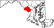
U.S. Routes Interstate Highways Roads by name Cabin John Parkway · Clara Barton Parkway · Cherry Hill Road · Connecticut Avenue · Georgia Avenue · Montrose Road · New Hampshire Avenue · Randolph Road · Sligo Creek Parkway · Wisconsin Avenue · 16th StreetRoads in Prince George's County, Maryland Maryland State Highways 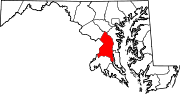
U.S. Routes Interstate Highways Roads by name Categories:- State highways in Maryland
- Roads in Montgomery County, Maryland
- Roads in Prince George's County, Maryland


Wikimedia Foundation. 2010.