- Chesapeake Bay impact crater
-
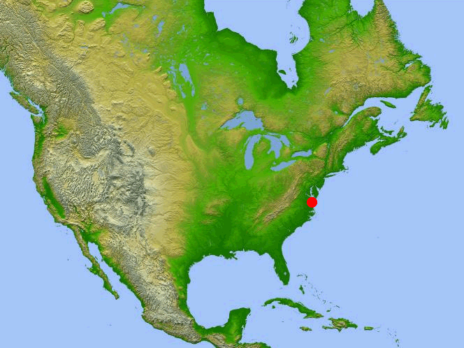
 Location of the crater in North America
Chesapeake Bay impact crater Impact crater/structure Confidence confirmed Diameter 85 km (53 mi) Depth 1.3 km (0.81 mi) Age 35 million years Drilled Yes Location Location Chesapeake Bay Coordinates 37°17′0″N 76°1′0″W / 37.283333°N 76.016667°WCoordinates: 37°17′0″N 76°1′0″W / 37.283333°N 76.016667°W
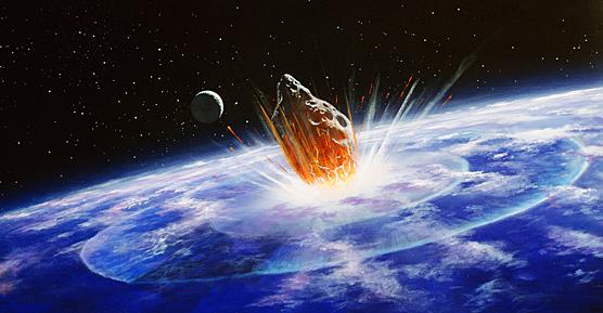
[1]Country United States State Virginia The Chesapeake Bay impact crater[1] was formed by a bolide that impacted the eastern shore of North America about 35 million years ago, in the late Eocene epoch. It is one of the best-preserved "wet-target" or marine impact craters, and the largest known impact crater in the U.S. Continued slumping of sediments over the rubble of the crater has helped shape Chesapeake Bay.
Contents
Formation and aftermath
During the warm, late Eocene, sea levels were high, and the Tidewater region of Virginia lay in the coastal shallows. The shore of eastern North America, about where Richmond, Virginia is today, was covered with dense tropical rainforest, and the waters of the gently sloping continental shelf were rich with marine life that was depositing dense layers of lime from their microscopic shells.
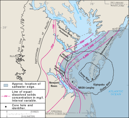
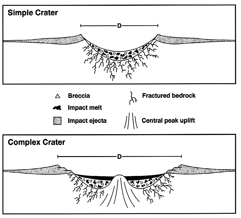
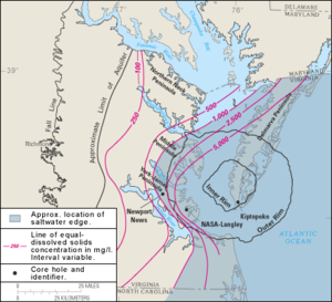 Boundaries of the crater
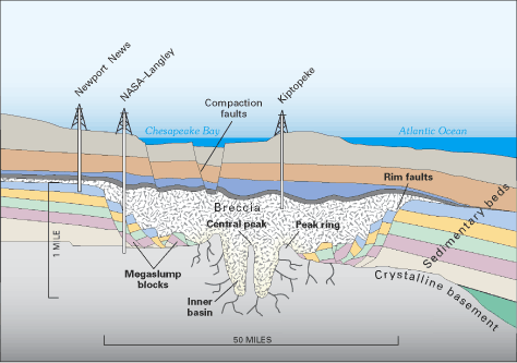
The bolide impacted at a speed of many kilometers per second, punching a deep hole through the sediments and into the granite continental basement rock. The bolide itself was completely vaporised, with the basement rock being fractured to depths of 8 km (5.0 mi), and a peak ring being raised around it. The deep crater, 38 km (24 mi) across, is surrounded by a flat-floored terrace-like ring trough with an outer edge of collapsed blocks forming ring faults. The entire circular crater is about 85 km (53 mi) in diameter and 1.3 km (0.81 mi) deep, an area twice the size of Rhode Island, and nearly as deep as the Grand Canyon. Numerical modeling techniques by Collins, et al. indicate that the post-impact diameter was likely to have been 40 km (25 mi), rather than the observed 85 km (53 mi).[2]
The surrounding region suffered massive devastation. USGS scientist David Powars, one of the impact crater's discoverers, has described the immediate aftermath: "Within minutes, millions of tons of water, sediment, and shattered rock were cast high into the atmosphere for hundreds of miles along the East Coast." An enormous seismic tsunami engulfed the land and possibly even overtopped the Blue Ridge Mountains. The sedimentary walls of the crater progressively slumped in, widened the crater, and formed a layer of huge blocks on the floor of the ring-like trough. The slump blocks were then covered with the rubble or breccia. The entire bolide event, from initial impact to the termination of breccia deposition lasted only a few hours or days. In the perspective of geological time, the 1.2 km (0.75 mi) breccia is an instantaneous deposit. The crater was then buried by additional sedimentary beds that have accumulated during the 35 million years following the impact.
Another, smaller bolide impact site, the Toms Canyon impact crater, lies about 322 km (200 mi) to the northeast, on the continental shelf off the coast of New Jersey. Having also been dated to the late Eocene, it is possible that this crater may have been formed in the same impact event as the Chesapeake Bay crater.
Discovery
 Profile view of the crater
Until 1983, no one suspected the existence of a large impact crater buried beneath the lower part of the Chesapeake Bay and its surrounding peninsulas. The first hint was a 20 cm (8 in) thick layer of ejecta that turned up in a drilling core taken off Atlantic City, New Jersey, far to the north. The layer contained the fused glass beads called tektites and shocked quartz grains that are unmistakable signs of a bolide impact.
In 1993, oil exploration revealed the extent of the crater.[citation needed]
Effects on local rivers
The continual slumping of the rubble within the crater has affected the flow of the rivers and shaped the Chesapeake Bay. The impact crater created a long-lasting topographic depression, which helped predetermine the course of local rivers and the eventual location of Chesapeake Bay. Most important for present-day inhabitants of the area, the impact disrupted aquifers. The present freshwater aquifers lie above a deep salty brine, making the entire lower Chesapeake Bay area susceptible to groundwater contamination.
The crater is also one of three factors contributing to the sinking of land near the Chesapeake Bay. For example, Hampton Roads is gradually sinking at a rate between 0.15 and 0.23 meters (5 and 7.5 inches) per century. This is occurring because of the slippage of the coast into the crater, “isostatic rebound” of the crust of the earth from the weight of long absent glaciers, and groundwater removal.[3]
See also
- Silverpit crater
- Popigai crater of similar age
- Grande Coupure
References
- ^ a b "Chesapeake". Earth Impact Database. University of New Brunswick. http://www.passc.net/EarthImpactDatabase/chesapeake.html. Retrieved 2008-12-30.
- ^ Collins, Gareth, et al.; Wünnemann, Kai (2005). "How big was the Chesapeake Bay impact? Insight from numerical modeling". Geology 33 (12): 925–928. doi:10.1130/G21854.1.
- ^ Koch, James V. "Costs of Defending Against Rising Sea Levels and Flooding in Mid-Atlantic Metropolitan Coastal Areas: The Basic Issues" JRAP 40(1): 53-60. © 2010 MCRSA.http://www.jamesvkoch.com/uploads/koch40_1_pdf.pdf
- Poag, C. Wiley. Chesapeake Invader: Discovering America's Giant Meteorite Crater. Princeton, NJ: Princeton University Press, 1999. ISBN 0-691-00919-8
- Post-impact Effects of the Eocene Chesapeake Bay Impact, Lower York-James Peninsula, Virginia, 31st Annual Meeting, Virginia Geological Field Conference, Williamsburg, Virginia, Oct. 19 and 20, 2001, G.H. Johnson et al. (fieldtrip guidebook)
External links
- A brief introduction to the Chesapeake Bay Impact Crater.
- USGS, 'Investigating the Chesapeake Bay Impact Crater.'
- USGS, 'The Chesapeake meteorite: message from the past.'
- 'The Chesapeake Bay bolide: modern consequences of an ancient cataclysm.'
- Earth Impact Database, a website concerned with over 160 identified impact craters on the Earth.
- Satellite image of the region (from Google Maps)
- Chesapeake Bay Impact Structure Deep Drilling Project
- 'North American Plate, mid-Atlantic Inversion a result of the Chesapeake Invader?' www.impacttectonics.org
Categories:- Earth Impact Database
- Chesapeake Bay
- Impact craters of the United States
- Eocene impact craters
- Geography of Virginia
- Geography of Maryland
Wikimedia Foundation. 2010.