- Clwyd
-
Clwyd 
Clwyd shown within Wales in its original bordersGeography Status Non-metropolitan county (1974–1996) Preserved county (1996–) 2003 area 2,910 km²
Ranked 4thHQ Mold History Origin Administrative county of Flintshire
Administrative county of Denbighshire (most)
Rural district of EdeyrnionCreated 1974 Abolished 1996 Succeeded by Conwy
Denbighshire
Flintshire
Wrexham
Preserved county of ClwydDemography 1981 population 390,200 1991 population 402,927 2007 population 491,100 (est; 2003 borders)[1]
Ranked 2ndPolitics Governance Clwyd County Council 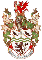
Coat of arms of Clwyd County CouncilSubdivisions Type Non-metropolitan districts 
Units 1. Colwyn
2. Rhuddlan
3. Glyndŵr
4. Delyn
5. Alyn & Deeside
6. Wrexham MaelorClwyd (Welsh pronunciation: [ˈklʊɨd]) is a preserved county of Wales, situated in the north-east, bordering England with Cheshire to its east, Shropshire to the south-east, and the Welsh counties of Gwynedd to its immediate west and Powys to the south. It additionally shares a maritime border with the metropolitan county of Merseyside along the River Dee. Between 1974 and 1996, it was a county with a county council, and it was divided into six districts. It is named after the River Clwyd, which runs through the region. It was also a Royal Mail postal county before the postal county scheme was abolished in 1996. Clwyd County Council was based in the county town of Mold.
Contents
History
From the late 1950s, the radical reform of local government in Wales was considered more pressing than that in England, due to the small size of many of the existing authorities, especially the upper tier county councils. The Local Government Commission for Wales set up in 1958 was the first to recommend wholesale amalgamation of the administrative counties outside Glamorgan and Monmouthshire, with extensive boundary changes; however the then Minister of Housing and Local Government Sir Keith Joseph decided not to accept the report, noting that county amalgamations in England had been highly unpopular when proposed.[2]
In 1967, after a change of government, the Secretary of State for Wales Cledwyn Hughes published a white paper which revived the idea of amalgamation, but instead of the boundary changes proposed in the previous report, treated each county as a whole. The report recommended a single new county of Gwynedd incorporating Denbighshire, Flintshire, Caernarfonshire, Merionethshire and Anglesey. The white paper stated that "the need for early action is particularly urgent in Wales", and so the issue was not referred to a Royal Commission as in England.[3] Opponents criticised the proposed new county for being too large, and in November 1968 a new Secretary of State announced that Gwynedd would be divided into two.[4]
This revised proposal was continued in a further white paper in March 1970, although this proposed that the counties be unitary authorities which would have no district councils below them. The incoming Conservative government resurrected two-tier local government in a consultative document published in February 1971, again with the same upper-tier boundaries.[5] Some minor changes having been made to the existing county boundaries due to special local factors, the Local Government Act 1972 duly created Clwyd as a merger of Flintshire with most of Denbighshire, along with the Edeyrnion Rural District from Merionethshire. The 1970 white paper had introduced the name of Clwyd by reference to the River Clwyd and the Clwydian range of hills; Clwyd was the only new Welsh county which did not take its name from an ancient kingdom.
Districts
For second-tier local government purposes, Clwyd was divided into six districts, each being operated by a district or borough council.
These were abolished, along with the county itself, on 1 April 1996.
Coat of Arms
Clwyd County Council's coat of arms was granted in December 1974. It features the cross and choughs from Flintshire's shield, which itself came from the traditional arms of Edwin of Tegeingl. The black lion of the Princes of Powys Fadog is taken from Denbighshire's shield. The Welsh dragon, the 'Peace Badge' of Edward the Black Prince, along with Rhuddlan Castle, are related to historical events which have taken place in Clwyd.[6]
Abolition
Clwyd County Council and its districts were abolished by the Local Government (Wales) Act 1994, and local government would be replaced by the four unitary authorities of Flintshire, Wrexham County Borough, Denbighshire, and parts of Conwy (along with some smaller communities moving to Powys). The Act also abolished the County, and states the term "county" would be synonymous with the "principal areas" created by the 1994 Act. However the Act then created a further set of "preserved counties", which were based on the 8 created by the 1972 Act. These Preserved Counties, similar in respect to English Ceremonial counties, would be retained for a variety of purposes, including Lieutenancy and Shrievalty.
Clwyd County Council and its six districts ceased operations at midnight on 1 April 1996, and local government was immediately transferred to the new principal areas of Conwy, Denbighshire, Flintshire and Wrexham. The Preserved County of Clwyd also came into effect as of that date.
2003 boundary review
In 2003, the borders of Clwyd were changed to cover the remainder of Conwy (which had previously been part of Gwynedd), which was part of a Wales-wide re-organisation of the preserved counties, so that boundaries of the preserved counties would contain whole current principal areas only.[7]
These moves were met with some criticism, as the preserved counties were created to sustain a stable and continuing county layout, which would counter act to interim local government reviews affecting principal areas. This led to some areas, such as the Aberconwy district, moving to a preserved county it had never been administered by in the past, and therefore these moves went generally unreported due to the preserved county's limited status. A report by the Association of British Counties suggested instead that stability in preserved county boundaries could be achieved by aligning them the historic counties as they were before 1974. The re-use of historic county names for 1996 principal areas with extremely different boundaries was also an apparent and confusing issue. The Association called for the Local Government Boundary Commission for Wales to abolish the 8 counties as preserved counties, and replace them with the 13 historic counties for ceremonial and geographic uses.[8] Despite the issues, the Boundary Commission proceeded to retain the 8 preserved counties, and modified their borders in 2003 to match with the incumbent principal area boundaries.
The 2003 arrangement brings towns such as Llandudno, Conwy and Betws y Coed into the preserved county of Clwyd.
Legacy
Many local organisations still make use of the "Clwyd" name. Some of organisations and facilities include:
- Clwyd Theatr Cymru in Mold
- Clwyd Family History Society
- Clwyd-Powys Archaeological Trust
- Clwyd League
- Clwyd Area Scouts
- Clwyd County Darts Association
- Clwyd Pension Fund (Local Government pension scheme inherited from Clwyd County Council, now providing pension schemes for Wrexham, Flintshire and Denbighshire unitary authorities and former districts).
The position of Lord Lieutenant of Clwyd also continues as the Monarch's personal representative as with the other seven preserved counties of Wales. The current Lord Lieutenant is Trefor Jones, who has held the position since 2001.
Geography
Clwyd is bordered by the preserved/ceremonial counties of Gwynedd to the west, Powys to the south, Shropshire to the south-east, Cheshire to the east and Merseyside over the River Dee. Since the 2003 boundary changes, its coastline has extended from the Dee Estuary in Flintshire through to Llanfairfechan in Conwy. The east of the county is fairly urbanised, particularly areas such as Wrexham, Deeside and the commuter settlements close to Chester. The west, however is more rural, with Snowdonia National Park in eastern areas of Conwy. Large coastal settlements include Rhyl and Prestatyn in Denbighshire, moving westwards to Abergele, Colwyn Bay and Llandudno. Central areas of Clwyd feature the mountainous Clwydian Range and Berwyn range, and the Vale of Clwyd in the central north is a rich agricultural area. The population as of 2007 is estimated at 491,100, based on figures for the four component unitary authority areas.
Clwyd consists of the whole of the historic county of Flintshire, and most of Denbighshire. Since 2003 it has also included the former district of Aberconwy, which lies in the historic county of Caernarfonshire. Edeyrnion Rural District was also part of Merionethshire.
 Clwyd as a preserved county since 2003.
See also
- List of Lord Lieutenants of Clwyd
- List of High Sheriffs of Clwyd
- List of places in Denbighshire
- List of places in Flintshire
- List of places in Conwy
- List of places in Wrexham county borough
References
- ^ 2007 population estimate (using 2003 preserved borders for Wrexham, Denbighshire, Conwy and Flintshire), Office for National Statistics, http://www.statistics.gov.uk/downloads/theme_population/Mid_2007_UK_England_&_Wales_Scotland_and_Northern_Ireland%20_21_08_08.zip, retrieved 15 October 2008
- ^ Bruce Wood, "The Process of Local Government Reform 1966–74", George Allen & Unwin Ltd, 1976, p. 117-8.
- ^ "Local Government in Wales", Cmnd. 3340, July 1967.
- ^ Bruce Wood, "The Process of Local Government Reform 1966–74", George Allen & Unwin Ltd, 1976, p. 123.
- ^ Bruce Wood, "The Process of Local Government Reform 1966–74", George Allen & Unwin Ltd, 1976, p. 125-6.
- ^ Civic Heraldry of England & Wales, http://www.civicheraldry.co.uk/wales_7496.html, retrieved 28 January 2009
- ^ The Preserved Counties (Amendment to Boundaries) (Wales) Order 2003 Retrieved on 19 May 2009
- ^ Preserved Final Appendix 3 (LGBC Wales) Retrieved on 19 May 2009
Preserved counties of Wales Clwyd • Dyfed • Gwent • Gwynedd • Mid Glamorgan • Powys • South Glamorgan • West Glamorgan
Categories:

Wikimedia Foundation. 2010.