- Warrington
Infobox Settlement
official_name = The Borough of Warrington
other_name =
native_name =
nickname =
settlement_type = Borough &Unitary authority area (1998)
motto =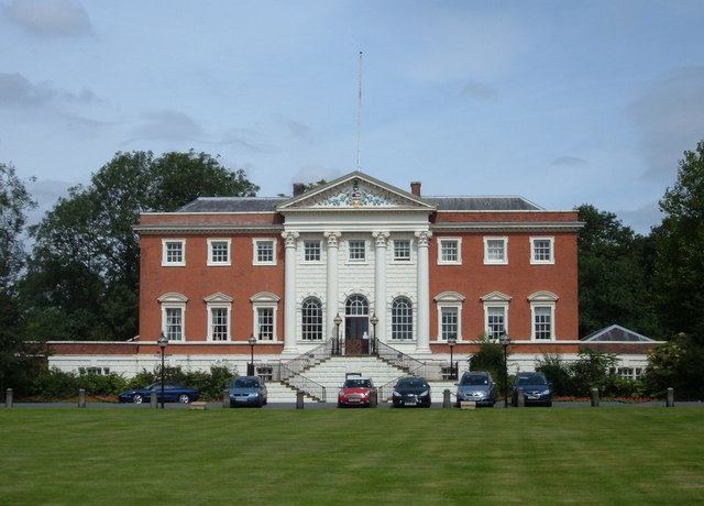
imagesize = 280px
image_caption =Warrington Town Hall
flag_size =
image_
seal_size =
image_shield =
shield_link =
shield_size =
image_blank_emblem = Warrington_Coat_of_Arms.jpg
blank_emblem_type = Coat of Arms of the Borough Council
blank_emblem_size = 150px
blank_emblem_link = Warrington Borough Council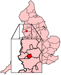
mapsize = 200 * 247
map_caption = Warrington shown within England
mapsize1 =
map_caption1 =
image_dot_
dot_mapsize =
dot_map_caption =
dot_x = |dot_y =
pushpin_
pushpin_label_position =
pushpin_map_caption =
pushpin_mapsize =
subdivision_type = Sovereign state
subdivision_name = United Kingdom
subdivision_type1 =Constituent country
subdivision_name1 = England
subdivision_type2 = Region
subdivision_name2 =North West England
subdivision_type3 = Ceremonial county
subdivision_name3 =Cheshire
subdivision_type4 = Admin HQ
subdivision_name4 =Warrington Town Hall
government_footnotes =
government_type =Unitary authority
leader_title = Governing body
leader_name = Warrington Borough Council
leader_title1 = Mayor
leader_name1 = Cllr Mr Graham Welborn
leader_title2 = MPs:
leader_name2 =Helen Jones (L)Helen Southworth (L)
leader_title3 =
leader_name3 =
leader_title4 =
leader_name4 =
established_title = Founded
established_date = 8th century
(exact date unknown)
established_title2 = Town charter
established_date2 = 12th century
(exact date unknown)
established_title3 = Unitary Authority status
established_date3 = 1998
area_magnitude =
unit_pref =
area_footnotes =
area_total_km2 =
area_land_km2 =
area_water_km2 =
area_total_sq_mi =
area_land_sq_mi =
area_water_sq_mi =
area_water_percent =
area_urban_km2 =
area_urban_sq_mi =
area_metro_km2 =
area_metro_sq_mi =
area_blank1_title =
area_blank1_km2 =
area_blank1_sq_mi =
population_as_of = English statistics year
population_footnotes =
population_note =
population_total = EnglishDistrictPopulation|ONS = 00EU (Ranked EnglishDistrictRank|ONS = 00EU)
population_density_km2 =
population_density_sq_mi =
population_metro =
population_density_metro_km2 =
population_density_metro_sq_mi =
population_urban =
population_density_urban_km2 =
population_density_urban_sq_mi =
population_blank1_title =
population_blank1 =
population_density_blank1_title =
population_density_blank1_km2 =
population_density_blank1_sq_mi =
population_blank2_title = Ethnicity
population_blank2 = 96.9% White
1.2% South Asian|
population_density_blank2_km2 =
population_density_blank2_sq_mi =
timezone =Greenwich Mean Time
utc_offset = +0
timezone_DST =
utc_offset_DST =
latd = 53 |latm = 23 |lats = |latNS = N
longd = 2 |longm = 36 |longs = |longEW = W
elevation_footnotes =
elevation_m =
elevation_ft =
postal_code_type = Postcode
postal_code = WA
area_code = 01925
blank_name =
blank_info = GB-WRT
blank1_name = ONS code
blank1_info = 00EU
blank2_name = OS grid reference
blank2_info = gbmappingsmall|SJ605885
blank3_name = NUTS 3
blank3_info = UKD21
blank4_name =
blank4_info =
website = [http://www.warrington.gov.uk www.warrington.gov.uk]
footnotes = Warrington is a large town borough andunitary authority area inCheshire ,England . It stands on the banks of theRiver Mersey , which is tidal to the west of theweir atHowley . The population of the borough of Warrington, including its 18civil parish es, is around 194,000. Its population has more than doubled since its designation as a New Town in 1968.Historically a part of
Lancashire , Warrington was founded by theRomans at an important crossing place on the River Mersey. A new settlement was established by theSaxons and by theMiddle Ages , Warrington had emerged as amarket town at an important bridging point. A local tradition of textile and tool production dates from this time.The expansion and urbanisation of Warrington largely coincided with the
Industrial Revolution , particularly after the Mersey was made navigable in the 18th century.The
West Coast Mainline runs north to south through the town, and theLiverpool toManchester railway (the Cheshire Lines route) west to east. TheManchester Ship Canal cuts through the south of the borough (west to east). The M6, M56 andM62 motorway s form a partial box around the town.People born (or living) in Warrington are known as "Warringtonians"cite web | url = http://smartnews.warrington.gov.uk/index.asp?37290 | title = "Tribute to famous Warringtonian Joseph Priestley" | publisher = Warrington Borough Council Smartnews. NB: In addition to verifying the notability of J Priestley, this reference demonstrates the use of the term "Warringtonian" | author = Gary Jenkins (Senior Communications Officer, Warrington Borough Council)] . The modern Borough of Warrington was formed in 1974 with the amalgamation of the former
County Borough of Warrington , part of the Golborne Urban District, the Lymm Urban District, part of the Runcorn Rural District, the Warrington Rural District and part of the Whiston Rural District.History
Warrington has been a major crossing point on the
River Mersey since ancient times and there was a Roman settlement at Wilderspool [.Hinchcliffe J & Williams J H, ROMAN WARRINGTON: Excavations at Wilderspool 1966 - 9 & 1976,Brigantia Monograph No 2, Manchester University 1992 ] . Inmedieval times Warrington's importance was as a bridging point of the River Mersey, and it was a fulcrum in theEnglish Civil War . The armies ofOliver Cromwell and theEarl of Derby both stayed near the old town centre (the parish church area). Popular legend has it that Cromwell lodged in the building which survives on Church Street as The Cottage Restaurant, though it is likely that the actual place was nearby, possibly next door. The Marquis of Granby public house bears a plaque stating that theEarl of Derby 'had his quarters near this site'. Dents in the walls of the parish church are rumoured to have been caused by thecannon s from the time of the Civil War.Industrial history
Warrington was a centre of
steel (particularlywire ),textiles ,brewing ,tanning andchemical industries. [Rylands, Rylands of Warrington, 1805-1955: The Story of Rylands Brothers Limited, Harley Publishing, 1956 ]Heavy industry declined in the 1970s and 1980s but the growth of the new town around Warrington led to a great increase in employment in light industry, distribution and technology. Travel-to-work patterns are unusual, with many residents working outside the borough and many employees living elsewhere.
IRA bombing
On 20 March 1993, the
Provisional Irish Republican Army (IRA) exploded two bombs in Warrington town centre. The blasts killed two children: three year old Jonathan Ball died instantly, and twelve year old Tim Parry died five days later in hospital. Their deaths provoked widespread condemnation of the organisation responsible. The blast followed a bomb attack a few weeks earlier on a gas storage plant in Warrington.Tim Parry's father founded The Peace Centre (formerly the Tim Parry Jonathan Ball Peace Centre) as part of a campaign to reconcile communities in conflict. The centre opened on the seventh anniversary of the bombing in 2000.
Other history
Warrington is notable in political history for being the first place to field a candidate for the then newly-formed Social Democratic Party; former Home Secretary
Roy Jenkins stood for Parliament in 1981 but lost to Labour Party candidate Doug Hoyle by a small number of votes.However, many people, particularly Americans, will remember Warrington best as the location of Burtonwood RAF base, one of (if not the) largest
Royal Air Force (RAF) bases in England and the largestUS Air Force base outside the United States. During World War II, Burtonwood was visited by major celebrities likeHumphrey Bogart andBob Hope who entertained theGI s. The base was closed in 1993.There was a further RAF training camp at
Padgate , a Royal Naval air base at Stretton and an army base at the Peninsula Barracks in O'Leary Street, now used by theTerritorial Army .Governance
Historically part of Lancashire, Warrington was incorporated as a
municipal borough in 1847 under theMunicipal Corporations Act 1835 . Warrington acquiredcounty borough status upon reaching a population of 50,000 in 1900 and until 1974 was known as theCounty Borough of Warrington . As part of proposed local government reforms of England, in 1969 theRedcliffe-Maud Report suggested merging Warrington with eitherMerseyside orGreater Manchester metropolitan counties. Lobbying by the borough council averted this. But, since these County boundary changes were to make Warrington non-contiguous with Lancashire, under the local government reforms of 1974, Warrington, incorporatingLymm Urban District and part ofRuncorn Rural District from Cheshire, and part ofWarrington Rural District , was made a borough withinCheshire County Council .On April 1, 1998 Warrington became an independent
unitary authority , though it is still served byCheshire Police andCheshire Fire and Rescue Service , and forms part of Cheshire for ceremonial purposes, such as the Lord Lieutenancy. The current borders of Warrington Borough cover the formerCounty Borough of Warrington, Lymm Urban District,Warrington Rural District and part ofGolborne Urban District, part ofRuncorn Rural District and part ofWhiston Rural District . Warrington has applied unsuccessfully for city status, the most recent attempt being after the opening of the Peace Centre as a "City for Peace".The political makeup of the borough council is as follows:
*9 Liberal Democrat Wards:Appleton ,Grappenhall andThelwall ,Great Sankey North,Great Sankey South,Latchford West, Poulton North,Stockton Heath , Westbrook, Whittle Hall.
*7 Labour Wards:Birchwood ,Burtonwood andWinwick , Fairfield & Howley,Latchford East,Orford , Poplars & Hulme, and Rixton & Woolston.
*2 Conservative wards:Culcheth , Glazebury &Croft , andHatton ,Stretton & Walton
*4 "split" wards:Bewsey and Whitecross (2 Liberal Democrat, 1 Labour),Lymm (2 Liberal Democrat, 1 Conservative), Penketh & Cuerdley (2 Conservative, 1 Labour), Poulton South (1 Labour, 1 Liberal Democrat).Current councillor party composition:
In spite of its proximity to significant retail areas in Manchester, Liverpool, Chester and the out-of-town Trafford Centre, Warrington continues to have one of the larger shopping centres in North West England. Despite the competition, Warrington has seen an increase in its customer trade, due in part to the modernisation of the town centre. It has a shopping mall (Golden Square) first opened in 1974, which has been extended to include a
Debenhams store, and a new bus station. The old Cockhedge Textile Mill was demolished and replaced by another shopping mall. The main shopping streets are Buttermarket Street, Horsemarket Street, Sankey Street and Bridge Street. Where these four streets intersect at Market Gate, there is an award-winning redevelopment with a large fountain and "guardians" (known locally as "the skittles") designed byHoward Ben Tré . The town also has a large indoor market, and several other small shopping malls, such as Hatters Row. In the surrounding modern suburbs, there are several shopping areas, from small groups of shops to malls such as Birchwood Mall.IKEA chose Warrington as the location for their first store when they came to the UK; the store is located in the large out-of-town shopping area of Gemini, which has a largeMarks and Spencer (the biggest outside London),Toys "R" Us , and Next outlets.Developments
Warrington is home to one of the most important strategic development projects in Europe in the
Omega Development Site close to theM62 . It will be a vibrant, active and sustainable business community which is to be developed in stages over the next 30 years. The site for this is the 575 acres of space on the formerBurtonwood Airbase . The cost of this is set to reach £1billion.Other developments in Warrington include the Wire Works on Winwick Street which is set to transform the gateway into the town centre with a mixture of retail, cafes, bars, apartments, and an 8-screen cinema.
Transport
The town has two main railway stations. Bank Quay is on the main West Coast Main Line between London Euston and Glasgow Central and the Manchester Piccadilly to
North Wales via Chester line. Central is on the Liverpool to Manchester (viaWidnes and Warrington) line with through services to the North East and to East Anglia. Bank Quay is much altered, but Central (built 1873) is of some architectural merit, featuring polychromatic brickwork. Both have undergone some refurbishment. There are also railway stations in the suburbs at Padgate, Sankey and Birchwood.The town lies close to the
M62 ,M6 andM56 motorways and midway between Liverpool and Manchester airports.Warrington Borough Transport , one of the fewmunicipal bus companies to survive in public ownership, runs most bus services within the town.First Group andArriva Northwestern provide bus links to surrounding towns and cities such as Manchester, the Trafford Centre, Liverpool, St Helens, Runcorn, Widnes and Chester. A new real-time passenger information system has been installed. A new bus station known as Warrington Interchange opened in 2006 at the Golden Square Shopping Centre.The River Mersey runs through the heart of the town dividing it in two. There are only two main thoroughfares crossing the Mersey in Warrington: at Bridge Foot and at the Kingsway Bridge. Before the M6 was built, these routes were very busy with through traffic.
The
Manchester Ship Canal runs through the south of the town; three swing bridges and a high-level cantilever bridge provide crossing points, and another high-level crossing is planned downstream nearer toRuncorn . Although shipping movements on the ship canal are far less frequent than in years past, they can cause severe delay to local road traffic. The picturesqueBridgewater Canal runs through the borough from the scenic village of Lymm to Walton Hall and Gardens, a local park/leisure area.Culture
.There is also
ten-pin bowling located at Winwick Quay, and indoor paintball. An indoor karting centre is located near to Bank Quay. A Laser Quest arena and a snooker club can also be found in Warrington, both located close to the town centre. Gulliver's Theme Park is located in Old Hall.A number of festivals, carnivals, and
walking day s are held annually in the Warrington area. Warrington Walking Day - originally a Sunday School festival - is held on the closest Friday to the last day of June, and the town centre is closed to traffic as churches walk together through the streets. [Forrest David, Warrington Walking Day: A Brief History]Other festivals, besides the many walking days, include:
*Appleton Bawming of the Thorn
*Croft Carnival
*Culcheth Community Day
*Glazebury Gala
*Grappenhall Welly Wanging Competition
*Howley Carnival
*Lymm May Queen
*Lymm Dickensian Festival
*Newton-le-Willows Music Festival
*Penketh Carnival
*St George 's Day Parade
*Thelwall Rose Queen
*Winwick Carnival
*Westy CarnivalWarrington also has many musical groups, including
Warrington Male Voice Choir ,Warrington Youth Orchestra and theNorth Cheshire Wind Orchestra .ports
Rugby League is the town's premier sports in the form ofWarrington Wolves who are nicknamed "The Wire" because of Warrington's history of wire making. The club moved in 2003 to theHalliwell Jones Stadium , leaving its home for over a century,Wilderspool Stadium .Warrington Wolves are the only team to have played every season in the top flight ofRugby League . The town is also home toWarrington Wizards who play their home matches atWilderspool Stadium . The Wizards are currently in theRugby League Conference . Warrington is represented in theBARLA leagues by Crosfields ARLFC, Bank Quay Bulls ARLFC, Rylands ARFLC, Woolston Rovers ARLFC, Latchford Albion ARLFC, Burtonwood Bulldogs ARLFC and Westbrook Tigers ARLFC.Football is represented by
Warrington Town atCantilever Park , next to theManchester Ship Canal . The club has several nicknames including Town, Yellows, Wire and Warriors. Warrington Town are currently in theNorthern Premier League Division One North .Liverpool FC Reserves also play in Warrington at the
Halliwell Jones Stadium .Warrington Athletic Club is based at Victoria Park, where a new eight-lane synthetic track was built in 1998, after the original track was destroyed in a fire the previous year.
Speedway racing, formerly known as Dirt Track racing was staged in Warrington in its pioneering era between 1928 and 1930. The track entered a team in the 1929 English Dirt Track League and the 1930Northern league . Efforts to revive the venue in 1947 failed to materialise.Education
Warrington is home to two colleges: Priestley Sixth Form and Community College and Warrington Collegiate. The
University of Chester has a campus atPadgate that was formerly part of Warrington Collegiate. Most of the high schools have their own post-16 provision (sixth-form ).The high schools throughout the borough are located at:
Birchwood ,Culcheth ,Appleton (known asBridgewater High School Warrington ), two inLatchford (Sir Thomas BotelerChurch of England High School andCardinal Newman Roman Catholic High School), Sankey,Lymm ,Padgate , Penketh,Westbrook (St. Gregory 'sRoman Catholic High School), Orford (William Beamont High School), and Woolston [from Warrington Borough Council's Community Information Resource] . Woolston High School is to be closed in 2012.There are also 74
primary schools in the borough, all of which feed into at least one of the above. [Count from Warrington Borough Council's community Information resource] .Landmarks
Sites of interest in Warrington include:
*The Town Hall (and its golden gates), formerly the home of the Philips family, Bank Hall (built 1750), and their scion,Nathaniel George Philips , the artist. [cite web | url=http://www.warrington.gov.uk/Leisureandculture/Localhistoryandheritage/Town_Hall_Guide.aspx | title=Town Hall Guide | publisher = Warrington Borough Council | year=2007 | accessdate=2007-05-23]
*The Academy, adissenter s' institute whereJoseph Priestley taught and which is now, after being moved from its original location, the offices of a local newspaper.
*"Cromwell's Cottage" (17th century), whichOliver Cromwell is said to have visited.
*The 14th century Parish Church of St Elphin, largely a Victorian rebuild with a convert|281|ft|m|sing=onspire , the sixth largest in the UK.
*St Wilfrid's Church, Grappenhall , Grade I listed medieval church.
*St Oswald's Church, Winwick , Grade I listed medieval church.
*Holy Trinity Church, 1758, Grade II* listed Georgian church at Market Gate.
*St Ann's Church, 1869, Grade II* church designed by John Douglas, now a rock climbing centre.
*St Mary's Church, Grade II church designed byE. W. Pugin andPeter Paul Pugin in Buttermarket.
*Warrington Museum & Art Gallery , Grade II listed building and one of the oldest municipal museums in the UK.
*The row of late Victorian terracotta shops on Bridge Street. [cite web | url=http://www.warrington.gov.uk/Images/6_Bridge_St_tcm31-3124.pdf | title=Bridge StreetConservation Area | publisher = Warrington Borough Council | year=2000 | accessdate=2007-05-23]
*The Woolworth's Building in Sankey Street (at least the upper storeys).
*TheArt Deco style Synergy nightclub which was originally a large cinema.
*The industrial modernistUnilever Soapworks.
*The Cheshire Lines railway warehouse, now redeveloped as apartments.
*TheWarrington Transporter Bridge , alisted building and aScheduled Ancient Monument . [English Heritage] .
*The Barley Mow, established in 1561, the oldest pub in Warrington.
*TheParr Hall , home to one of the few remainingCavaillé-Coll organs.
*Fiddlers Ferry Power Station
* TheHalliwell Jones Stadium home ofWarrington Wolves
*Bewsey Old Hall, a rebuilt medieval manor house.
*IKEA store which is located near the Gemini retail park. The first of the IKEA chain to be built in the UK. [cite web | url =http://www.guardian.co.uk/g2/story/0,,1240464,00.html |title = Ikea: The History | publisher= The Guardian | year=2004 | accessdate=2007-05-23]Notable residents
*18th century free-thinker and scientist
Joseph Priestley lived and taught in Warrington, at the Academy.
*William Beamont was a Victorian solicitor and local philanthropist who founded several churches and the municipal library, the first rate-aided library in the UK. [Oxford Dictionary of National Biography; William Beamont diaries in Warrington Library; [http://www.warrington.gov.uk/Councilanddemocracy/Councillorsdemocracyandelections/mayor/history.aspx]
*Entertainer George Formby (Junior) lived for many years in Warrington and is buried in Warrington Cemetery, with his father George Formby (Senior), also an entertainer. [ [http://archive.thisischeshire.co.uk/1996/11/1/252140.html Retrieval Date: August 23, 2008 http://www.findagrave.com/cgi-bin/fg.cgi?page=gr&GSln=Formby&GSfn=George&GSbyrel=in&GSdyrel=in&GScntry=5&GSob=n&GRid=1228& Retrieval Date: August 23, 2008]
*First class cricket erGeorge Duckworth was born in Warrington and playedTest cricket for England. He played first class cricket for Lancashire between 1923 and 1947. [cite web |url=http://content-uk.cricinfo.com/ci/content/player/11946.html |author= |title=George Duckworth player profile |publisher=Cricinfo.com |accessdate=2007-10-16]
*First class cricket erNeil Fairbrother was born in Warrington and played Test cricket for England. [cite web |url=http://content-uk.cricinfo.com/ci/content/player/12803.html |author= |title=Neil Fairbrother player profile |publisher=Cricinfo.com |accessdate=2007-10-16]
*The lateWilliam Norman ,VC (1832-1896), a local war hero, was born in Warrington. [ [http://www.homeusers.prestel.co.uk/stewart/manchest.htm List of VC holders buried in Manchester.] www.homeusers.prestel.co.uk. Retrieval Date: May 7, 2008.]
*George Sampson , dancer and winner ofBritain's Got Talent in 2008. [cite web
url =http://ukpress.google.com/article/ALeqM5jLv-DLR9hI1D8PZ60oapDmgOpAIQ
title = Breakdancer wins TV talent contest
accessdate = 2008-05-31
publisher =The Press Association ]
*DJ and TV presenter Chris Evans was born and grew up in Warrington.citeweb|url=http://www.independent.co.uk/news/people/chris-evans-life-story-681299.html|title=Chris Evans: Life Story|publisher=2001-04-14|accessdate=2008-10-08]Twin towns
*flagicon|Germany
Hilden , Germany
*flagicon|Czech RepublicNáchod ,Czech Republic ee also
*
List of parks in Warrington
*Warrington Dock References
External links
* [http://www.warrington.gov.uk Warrington Borough Council]
* [http://www.warringtonguardian.co.uk Warrington Guardian]
* [http://www.warrington-worldwide.co.uk Warrington Worldwide Online Newspaper]
* [http://www.wirefm.com 107.2 Wire FM]
* [http://www.warringtonwolves.com Warrington Wolves]
* [http://www.goldengateshousing.org.uk Golden Gates Housing]
* [http://www.warrington.pl Polish community in Warrington]
Wikimedia Foundation. 2010.