- Virginia State Route 267
-
State Route 267
Route information Maintained by Metropolitan Washington Airports Authority (Dulles Toll Road and Dulles Access Road) and TRIP II (Dulles Greenway) Length: 28.68 mi[1][2] (46.16 km) Existed: 1982 – present Major junctions West end: 
 US 15 / SR 7 in Leesburg
 SR 28 at Dulles Airport
 SR 7100 in Reston
 I-495 near Tysons Corner
East end:  I-66 near Falls Church
Highway system Virginia Routes
Primary • Secondary • History • Turnpikes←  I-264
I-264SR 269  →
→State Route 267 is a primary state highway in the U.S. state of Virginia. It consists of two end-to-end toll roads – the Dulles Toll Road and Dulles Greenway – as well as the Dulles Access Road,[3] which lies in the median of the Dulles Toll Road. The combined roadway provides a toll road for commuting and a free road for Dulles Airport access. The three sections are operated and maintained by separate agencies: the Dulles Toll Road and the Dulles Access Road by the Metropolitan Washington Airports Authority (MWAA) and the Dulles Greenway by an Australian company, Macquarie Atlas Roads.
Contents
Dulles Access Road
The Dulles Access Road is a four-lane, 13.65-mile[1][2] (21.97 km) highway that runs "inside" the Dulles Toll Road along its median. There are no general-access exits from the west-bound lanes, and no general-access entrances to the east-bound lanes, with the exception of gated slip ramps to and from the toll road that buses and emergency vehicles can use. The Access Road was built from the Beltway as part of the construction of Dulles Airport, and opened with the airport in 1962. It was extended to I-66 on December 22, 1982.[4]
Until 2006, the Dulles Access Road was operated by the Virginia Department of Transportation (VDOT) under contract with the Metropolitan Washington Airports Authority, the owner of the land under both the Access Road and the Dulles Toll Road,[5] and has the unsigned designation of State Route 90004.[6] The Dulles Airport Access Road can be used only for travel to and from Dulles Airport and other businesses (such as air freight, hotels, and gas stations) on the airport grounds. Although it is illegal to use the Access Road without conducting such "airport business", some commuters evade the toll and the traffic on the Toll Road by taking the Access Road to the airport, then "backtracking" to their exit. For a couple of years prior to the opening of the Dulles Toll Road, VDOT issued special stickers allowing commuters (for a fee) to backtrack legally along the access highway, but these were discontinued when the toll road opened.[7]
Since the opening of the Dulles Toll Road, the only major modification to the Access Road was the construction of a flyover exit ramp from the eastbound Access Road to State Route 7. This ramp bypasses congestion associated with the main toll plaza, when traffic from Dulles Airport attempts to exit at Route 7.
Dulles Toll Road
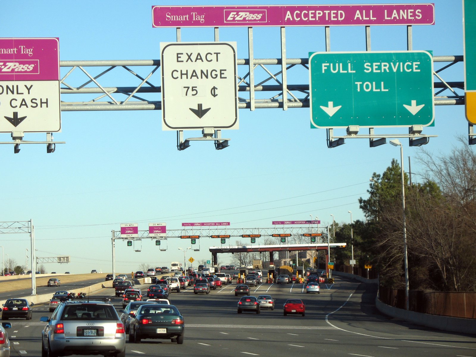
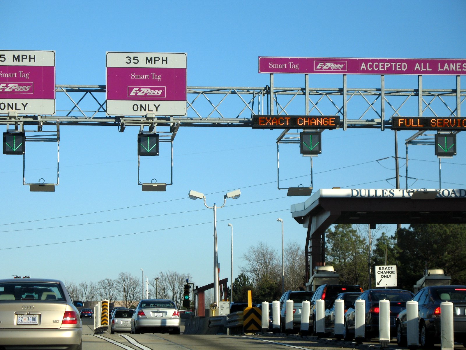
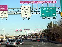 The main toll plaza of the Dulles Toll Road. At the time this photo was taken, the toll was $0.75. It has since increased.
 A closer view of the electronic and traditional lanes
 View of Route 267 from the Wiehle Avenue exit
The Dulles Toll Road is an eight-lane, 16.15-mile[1][2] (25.99 km) toll road.
History
In response to the development along the Dulles Access Road and the number of motorists who "backtracked" through the airport to commute to outer suburbs, the Virginia Department of Transportation determined a need for a limited access highway to serve points along the Access Road without subjecting airport traffic to congestion. It was built in 1984 by the Virginia Department of Transportation as a toll highway, because conventional funding was not available. It begins just inside the Capital Beltway near Falls Church at a connector to Interstate 66 to Washington, D.C., travels westward through Fairfax County past Dulles Airport, and terminates at the entrance to the Dulles Greenway, a privately owned toll road. Officially, the road is named the Omer L. Hirst - Adelard L. Brault Expressway, in honor of two Virginia state legislators. However, the road is rarely referred to by that name.[8] The speed limit is 55 miles per hour (90 km/h). The original construction had two lanes in each direction. A third lane was built to serve HOV traffic in 1992. For a short period between the end of construction and the start of HOV limits, single passenger vehicles used the lane and contacted government officials opposing the HOV policy. In response, Congress (which did not have direct control over the highway) passed special legislation prohibiting the imposition of HOV restrictions on the route.[9] As a compromise to resolve the situation, Virginia decided to lift the HOV restriction and to construct a fourth lane in each direction to serve HOV traffic.[10] However, unlike the third lane, officials did not allow non-HOV use at the end of construction in 1998, and avoided a repeat of the controversy.[11] As a practical matter, the right of way could not fit any additional lanes other than the current six in each direction. However, Rep. Frank Wolf again threatened to pass federal legislation prohibiting the fourth lane to be limited to HOV traffic.[12]
In 2005, five companies submitted proposals to VDOT to privatize the toll road which included payments to Virginia that could be used for transportation. In response MWAA made its own proposal to take over operation of the toll road from VDOT, assuming associated debts, and commit to building a rapid transit line in the median.[13] VDOT agreed and, on March 27, 2006, MWAA took over from Virginia the operation of the Dulles Toll Road, including the outstanding debt and the obligation to construct a rapid mass transit line (the Silver Line) in the median strip of the toll road.[14]
Description
From the Beltway, motorists exiting onto SR 267 toward Dulles Airport must choose between lanes marked Airport Traffic Only and To All Local Exits; the Airport Traffic Only lanes lead to the two westbound lanes of the Access Road. Eastbound traffic is routed differently; Dulles-originating traffic can choose destinations between Herndon exits (putting them on the mainline Toll Road) or further on (starting them on the Access Road), and transfer exits are provided from the Access Road to the Toll Road before the Herndon exits, Reston exits, and the Beltway. Access Road traffic to State Route 7 gets a separate exit ramp from those of the Toll Road, and then the two eastbound segments merge before the junction with Interstate 66.
A main toll plaza west of the Beltway interchange collects a $1.25 toll in both directions. In addition, toll booths located on westbound exit ramps and eastbound entrance ramps collect tolls of 75 cents; although at the Route 7 interchange, tolls are only collected from Route 267 east to Route 7 east. All tollbooths are equipped with electronic toll collection systems which accept either Smart Tag (Virginia) and E-ZPass (Virginia to Maine). 50 cents of each toll is attributable to the financing of a rapid mass transit line to Dulles Airport (see Silver Line (Washington Metro)). A main toll plaza surcharge increase is scheduled for January 1, 2012 (to $1.50).[15][16]
HOV-2 restrictions are in effect during weekday rush hours, 6:30 to 9:00 a.m. eastbound and 4:00 to 6:30 p.m. westbound, limiting the left lane to vehicles with two or more passengers between State Route 28 and the main toll plaza. Motorcycles and "clean fuel" vehicles (hybrid and compressed natural gas) are exempt from HOV restrictions in Virginia, allowing single-passenger vehicles of those types to use the lanes as well. During rush hour, the appropriate directions of Interstate 66 between the Beltway and U.S. Route 29 just outside Washington are HOV-2, as well as the portion of the Access Road between I-66 and SR 123.
Dulles Greenway
The Dulles Greenway is a privately owned toll road in Northern Virginia, running for 12.53 miles[1] (20.17 km) northwest from the end of the Dulles Toll Road to the Leesburg Bypass (U.S. Route 15/State Route 7). Although privately owned, the highway is also part of SR 267. The speed limit is 65 miles per hour (105 km/h).
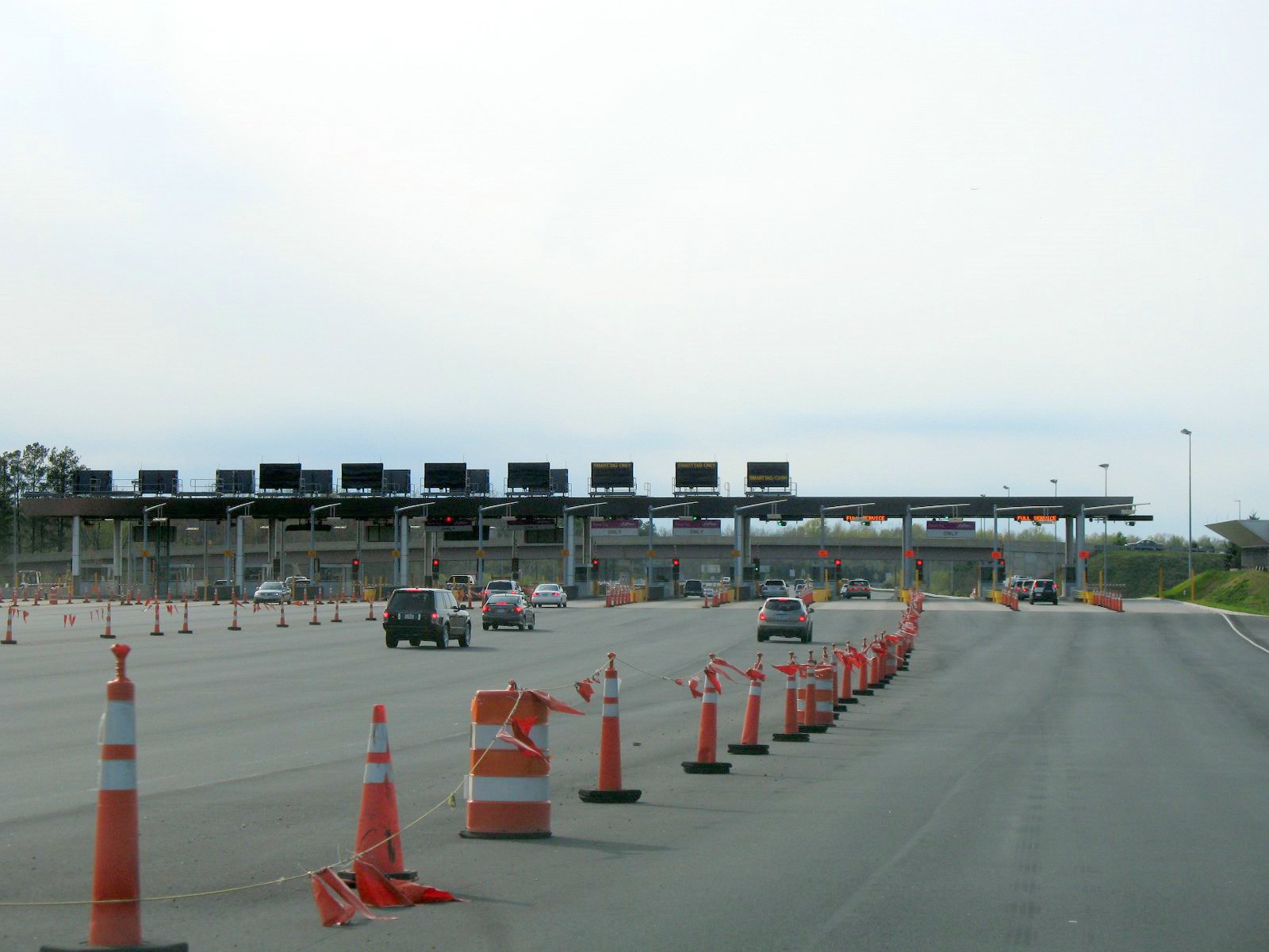
 The main toll plaza of the Dulles Greenway
The road was privately built and is not a public asset. The current owner is "Toll Road Investors Partnership II" (TRIP II), which is a consortium of the Bryant/Crane Family LLC, the Franklin L. Haney Co.,[17] and Kellogg Brown & Root (KB&R). On August 31, 2005, Australian firm Macquarie Infrastructure Group announced that they had paid $533 million to TRIP II to acquire its 86.7% ownership of the Greenway, and were negotiating with KB&R for the remaining ownership rights.[18]
History
The road was envisioned as early as the 1970s, when new residents were attracted to Loudoun County because of the relatively low cost of real estate. The Greenway proposal prompted the enactment of the Virginia Highway Corporation Act of 1988[19] that authorizes the construction of new toll roads without the use of eminent domain[20] under rates set by the Virginia Corporation Commission.[19] The law requires the facility to be turned over to the state after a stated time period.[21] The road was completed and opened in 1995, but the original owners defaulted on its loan due to lower than projected use.[22] It receives no public funds, was built with no subsidies, and is policed at its own expense, competing as a wholly private enterprise with the state-built and -maintained roads.[23] Tolls are computed to assure that the owner will recover the original investment plus a return on that investment. The losses incurred during the early years of the project are rolled forward to justify higher tolls in later years. Subsequent improvements, which were constructed in exchange for an extension of the toll road to 2056, include adding a third lane in each direction, resurfacing the entire road in 2009, and the construction of an improved eastbound exit ramp to Dulles Airport in 2009.[24]
Description
The main toll plaza for the Dulles Greenway is located just west of the exits for Route 28 and Dulles Airport. Additional toll plazas are located on westbound entrance ramps and eastbound exit ramps with the exception of Battlefield Parkway (Exit 2) in Leesburg. The toll varies depending on the toll plaza traversed. As of 1 July 2010[update], the base toll collected for two-axle vehicles ranges from $2.60 ($2.15 with E-ZPass) at the Shreve Mill Rd plaza to $4.45 at the main plaza to and from the Dulles Toll Road (including 75 cents for the Dulles Toll Road toll).[25] The maximum toll rises to $5.25 (including the 75-cent Dulles Toll Road toll) during "congestion pricing" hours, which are 6:30 a.m. to 9:00 a.m. eastbound and 4:00 p.m. to 6:30 p.m. westbound.[25] A previous increase in the base fare and the introduction of congestion pricing occurred in January 2009. Tolls are set to rise an additional 30 cents per trip in 2012.[26] Vehicles traveling through the main toll plaza to or from the Dulles Toll Road are charged two tolls: one for the Dulles Toll Road, and one for the Dulles Greenway. Cash tolls are accepted during limited hours, and credit cards and E-ZPass transponder payments are accepted at all times.[27] The Greenway is also one of two routes where a subscription membership (exclusive to E-ZPass) allows for an additional discount. Alternate (free) routes include State Route 7 and State Route 28, both of which are generally more congested.[28]
The Greenway was later widened to six lanes from the mainline toll plaza to Leesburg. Use of the Greenway has grown, reflecting the increased population of Loudoun County. In 1996, the Greenway served 6.3 million trips, growing to 21 million in 2006.[28] However, as a result of the January 2009 toll increase, usage has dropped to an average of 47,490 tolls a day.[22]
Controversies
The 1988 statute authorizing the private toll road permitted toll increases above the rate of inflation under a three-part test: (1) the new fee must not "materially discourage" drivers from using the road, (2) the company must not make more than a "reasonable rate of return" from the increase, and (3) the road's benefit must match its cost.[29] Critics claim that the drop in use following the 2009 toll increase is evidence that the test has not been met.[who?] Rep. Frank Wolf (R-Va.), the Congressman representing the area served by the road, stated, "It's highway robbery. It's a disgrace. Everyone knows that these tolls are ripping people off and there's not much we can do about it."[22]
Exit list
Route 267 uses sequential exit numbering (rather than distance-based exit numbering).
County/City Location* Mile # Destinations Notes Loudoun County Leesburg 1 
US 15 / SR 7 - Frederick, MD, Leesburg, WarrentonWestbound exit and eastbound entrance; signed as exits 1A (south/west) and 1B (north/east) 2 Battlefield Parkway No toll for vehicles traveling to or from Exit 1 3  SR 653 (Shreve Mill Road)
Ashburn 4  SR 659 (Belmont Ridge Road)
5  SR 901 (Claiborne Parkway)
6  SR 772 (Ryan Road) – Ashburn
Western terminus of Phase II of Silver Line 7  SR 607 (Loudoun County Parkway)
Sterling 8  SR 606 (Old Ox Road)
Eastbound to SR 28 North Toll Plaza 9A SR 28 south (Sully Road) – Centreville, Manassas9B SR 28 north (Sully Road) – SterlingWestbound exit and eastbound entrance Washington Dulles International Airport Washington Dulles International Airport A dedicated eastbound exit opened on June 30, 2009[30] End of Dulles Greenway, Beginning of Dulles Toll Road and Dulles Airport Access Road Fairfax County Herndon 10  SR 657 (Centreville Road) – Herndon, Chantilly
11 SR 7100 (Fairfax County Parkway) – Herndon, Reston, SpringfieldHerndon/Monroe Park & Ride. Reston 12  SR 602 (Reston Parkway)
13  SR 828 (Wiehle Avenue)
Western terminus of Phase I of Silver Line. 14  SR 674 (Hunter Mill Road)
Tysons Corner 15 Wolf Trap National Park Westbound exit and eastbound entrance 16 SR 7 (Leesburg Pike) – Tysons Corner, LeesburgSigned as exits 16A (east) and 16B (west) eastbound. 17  SR 684 (Spring Hill Road)
Toll Plaza -- Cars $1.25 each direction. Toll increases to $1.50 on January 1, 2012. No toll for vehicles traveling to or from Dulles Airport (separated roadway). 18 I-495 (Capital Beltway) - Baltimore, RichmondEastbound exit and westbound entrance 18 I-495 north (Capital Beltway) - BaltimoreWestbound exit and eastbound entrance 19A  SR 123 south (Chain Bridge Road) – Tysons Corner
19B SR 123 north (Chain Bridge Road) – McLeanFalls Church I-66 east - WashingtonEastbound exit and westbound entrance * Locations refer to unincorporated neighborhoods, and not city limits.
See also
References
- ^ a b c d 2005 Virginia Department of Transportation Jurisdiction Report - Daily Traffic Volume Estimates - Loudoun County PDF ( 634 KiB )
- ^ a b c 2005 Virginia Department of Transportation Jurisdiction Report - Daily Traffic Volume Estimates - Fairfax County PDF ( 3.99 MiB )
- ^ "Designated Interstate and Primary Route Numbers, Named Highways, Named Bridges and Designated Virginia Byways" (PDF). Virginia Department of Transportation. July 1, 2003. p. 24. http://www.virginiadot.org/info/resources/route-index-07012003.pdf. Retrieved 2009-04-13. "267 - STATE ROUTE: From Routes 7/15 in Leesburg to Route I-66 north of Falls Church, including the parallel lanes along the Dulles International Airport Access Road."
- ^ "Interstate 66 openings in Virginia and the District of Columbia". http://www.roadstothefuture.com/Int66_MetroViennaRte.html#I-66_Openings. Retrieved December 6, 2010.
- ^ "Airports Authority Wants to Control Dulles Toll Road". WTOP-FM. December 21, 2005. http://www.wtop.com/?nid=30&sid=654733. Retrieved 2009-04-13.
- ^ Froehlig, Adam; Mike Roberson (November 26, 2006). "VA 800 to 90005". Virginia Highway Index. http://www.vahighways.com/route-log/va800-999.htm. Retrieved 2009-04-13. "VA 90004 is the free Dulles Access lanes in the median of the toll VA 267. [...] VA 90004 is for access to the Dulles Airport only. A hefty ticket awaits you if you try to use it as a way to circumvent the VA 267 toll road."
- ^ Hodge, Paul (December 6, 1983). "I-66 Link Opens to Motorist Confusion". Loudon Extra (Washington Post). http://loudounextra.washingtonpost.com/news/1983/dec/06/i-66-link-opens-motorist-confusion/. Retrieved 2009-04-13. "Yesterday morning illegal commuters – those lacking special bumper stickers – were backtracking to Dulles and getting on the eastbound access highway at the rate of four or five a minute. But more than 75 percent of the backtracking commuter cars displayed the $2 FAA decals that mark them as legal commuters on the access road (but not on I-66)."
- ^ Bernstein, Adam (February 14, 2007). "Adelard L. 'Abe' Brault, 97; Influential N.Va. Senator". Washington Post. http://www.washingtonpost.com/wp-dyn/content/article/2007/02/13/AR2007021301208.html. Retrieved March 27, 2011. "In 1991, state legislators renamed the Dulles Toll Road the Omer L. Hirst-Adelard L. Brault Expressway, which, having met the fate of many other such renamings of roads, bridges and buildings, has not readily been adopted by commuters."
- ^ Bates, Steve (Sep 25, 1992). "Bill Seeks To End HOV Restrictions; Dulles Toll Road Targeted by Wolf". Washington Post: p. A1. http://pqasb.pqarchiver.com/washingtonpost/access/74051242.html?dids=74051242:74051242&FMT=ABS&FMTS=ABS:FT&type=current&date=Sep+25%2C+1992&author=Steve+Bates&pub=The+Washington+Post+(pre-1997+Fulltext)&desc=Bill+Seeks+To+End+HOV+Restrictions%3B+Dulles+Toll+Road+Targeted+by+Wolf&pqatl=google. Retrieved 2010-12-07.
- ^ "Bucking national trend, Georgia stands by HOV". Atlanta Journal Constitution: p. H1. November 29, 1998. http://nl.newsbank.com/nl-search/we/Archives?p_product=AT&p_theme=at&p_action=search&p_maxdocs=200&p_topdoc=1&p_text_direct-0=0EADA40C1B182E81&p_field_direct-0=document_id&p_perpage=10&p_sort=YMD_date:D&s_trackval=GooglePM. Retrieved 2010-12-07.
- ^ Bradley, Paul (October 3, 1992). "Wilder Lifts HOV Rule on Dulles Toll Road". Richmond Times Dispatch: p. B4. http://pqasb.pqarchiver.com/timesdispatch/access/617102851.html?dids=617102851:617102851&FMT=ABS&FMTS=ABS:FT&type=current&date=Oct+03%2C+1992&author=PAUL+BRADLEY&pub=Richmond+Times+-+Dispatch&desc=WILDER+LIFTS+HOV+RULE+ON+DULLES+TOLL+ROAD&pqatl=google. Retrieved 2010-12-07.
- ^ Robert W. Poole Jr. and C. Kenneth Orski. "HOT Lanes: A Better Way to Attack Urban Highway Congestion". Regulation 23 (1): p. 16. http://www.cato.org/pubs/regulation/regv23n1/poole.pdf. Retrieved 2010-12-07.
- ^ "Proposal to Operate the Dulles Toll Road and Build Rail to Loudoun County". MWAA. January 2006. http://www.metwashairports.com/file/CorridorProposal.pdf. Retrieved 2010-12-07.
- ^ "Governor Kaine Announces Partnership With Metropolitan Washington Airports Authority for Dulles Corridor" (PDF). Metropolitan Washington Airports Authority. March 27, 2006. http://www.mwaa.com/_/File/_/pr032706.pdf. Retrieved 2009-04-13.[dead link]
- ^ "Airports Authority Board Approves Toll Rate Increases on Dulles Toll Road" (PDF). Nov. 4, 2009. http://www.mwaa.com/_/file/_/pr2009_11_04.pdf. Retrieved 2009-12-19.[dead link]
- ^ Freeman, Sholnn (1 January 2010). "Dulles Toll Road fees rise to help pay for Silver Line; increases are criticized". The Washington Post. http://www.washingtonpost.com/wp-dyn/content/article/2009/12/31/AR2009123101624.html?hpid=newswell. Retrieved 1 January 2010.
- ^ "About FLH Company". http://www.flhcompany.com/about.html. Retrieved 3 December 2009.
- ^ Ginsberg, Steven (2005-09-01). "Australian Firm Buys Greenway". The Washington Post. http://www.washingtonpost.com/wp-dyn/content/article/2005/08/31/AR2005083102433.html. Retrieved 2009-04-13.
- ^ a b Virginia Code § 56-535.
- ^ Virginia Code § 56-541.
- ^ Virginia Code § 56-551.
- ^ a b c Kravitz, Derek (July 5, 2009). "Greenway Revenue, Traffic at Odds". Washington Post: p. C1.
- ^ Greenway, Dulles. "Dulles Greenway Facts & Myths". http://dullesgreenway.com/facts-myths.html. Retrieved 2009-06-04.
- ^ "Greenway Improvements". http://www.dullesgreenway.com/greenway_improvements.shtml. Retrieved 2010-12-07.
- ^ a b "TOLL INCREASE FOR DULLES GREENWAY". Toll Road Investors Partnership II, L.P.. 1 June 2010. http://www.dullesgreenway.com/documents/GreenwayAnnouncesTollInceaseEffJuly2010_000.pdf. Retrieved 14 July 2010.
- ^ Somashekhar, Sandhya (September 13, 2007). "Tolls Set To Rise On Dulles Greenway: Most Drivers Won't Be Affected Till '09". Washington Post: p. B03. http://www.washingtonpost.com/wp-dyn/content/article/2007/09/12/AR2007091201374.html. Retrieved 2009-04-13.
- ^ Retrieved 2009-0705.
- ^ a b Mummolo, Jonathan (July 1, 2007). "Greenway Drivers Face Dilemma: Tolls Up, but Few Good Alternate Routes Available". Washington Post: p. C1. http://www.washingtonpost.com/wp-dyn/content/article/2007/06/30/AR2007063000762.html. Retrieved 2009-04-13.
- ^ Virginia Highway Corporation Act of 1988, Va. Code § 56-542(I)(3).
- ^ Retrieved 2009-0705.
External links
- Metropolitan Washington Airports Authority - Dulles Toll Road
- VDOT - Dulles Toll Road
- Dulles Greenway website
- Virginia Highways Project: VA 267
- VA Route 267: Dulles Greenway, from The Roads of Northern Virginia
- VA Route 267: Dulles Toll Road, from The Roads of Northern Virginia
- VDOT: Virginia Toll Facilities FAQ
- History of Washington Dulles International Airport (see the section on "Access Roads")
- Dulles Rapid Mass Transit Corridor
Categories:- State highways in Virginia
- Transportation in Loudoun County, Virginia
- Roads in Fairfax County, Virginia
- Toll roads in Virginia
- Freeways in the United States


Wikimedia Foundation. 2010.