- Gugh
-
Coordinates: 49°53′47″N 6°19′58″W / 49.89626°N 6.33266°W
Gugh Cornish: Keow 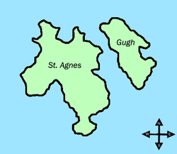
The islands of Gugh and St Agnes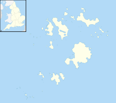
 Gugh
Gugh
Gugh shown within Isles of ScillyPopulation 3 (2001) Unitary authority Isles of Scilly Ceremonial county Cornwall Region South West Country England Sovereign state United Kingdom Post town ISLES OF SCILLY Postcode district TR22 Dialling code 01720 Police Devon and Cornwall Fire Isles of Scilly Ambulance South Western EU Parliament South West England UK Parliament St Ives List of places: UK • England • Cornwall Gugh (pronounced /ˈɡjuː/, rhyming with "few"; Cornish: Keow, meaning "hedge banks")[1] could be described as the sixth inhabited island of the Isles of Scilly, but is usually included with St Agnes with which it is joined by a sandy tombolo known as "The Bar" when exposed at low tide. The island is only one km long and about 0.5 km wide, with the highest point, Kittern Hill at 34 m.[2] The geology consists of Hercynian granite with shallow podzolic soils on the higher ground and deeper sandy soils on the lower ground. The former Gugh farm is just north of the neck across the middle of the island between the two hills. The two houses were designed and built in the 1920s by a Mr Cooper.[3]
The island lies within the Isles of Scilly Heritage Coast, is in the Isles of Scilly Area of Outstanding Natural Beauty and is managed by the Isles of Scilly Wildlife Trust. Vegetation cover is mainly wind-pruned heath or dense bracken and bramble with a small area of coastal grassland formed over blown sand which has accumulated near the bar.
The name is often mispronounced as "Goo", "Guff" or even "Gogh".
Contents
History
The earliest signs of occupation on Gugh are two groups, each, of entrance graves, and Bronze Age cairns. Entrance graves are either burial or ritual monuments and cairns are burial mounds. A lack of finds, most likely because of acid soils destroying any evidence, makes the dating of the monuments difficult but a few pottery remains date them to late Neolithic or early bronze age. On Kittern Hill there are five entrance graves, one of which Obadiah's Barrow was excavated in 1900 and ″disarticulate unburnt bones″ found. There is also a cluster of fourteen cairns which are linked by prehistoric field walls or banks but the relationship between the two is not established. The only menhir to be excavated on Scilly is the Old Man of Gugh, a 2.7 m tall standing stone which lies at the base of Kittern Hill, but there was no features or finds. There is also a cluster of nineteen cairns and a field system on the south part of Gugh along with a further two entrance graves. An English Civil War battery was built over one on Carn of Works and its chamber re-used as a magazine. The Civil War defences are concentrated around the Scillonian coast to defend the deep-water approaches.
Two kelp pits have been recognised, one on the north-east side of Kittern Hill and the second at Tol Tuppens. Burning seaweed was introduced in 1684 by Mr Nance on Teän to provide sodium carbonate for glass making and continued until 1835. Kelp burning only produces 2-3 percent sodium carbonate and during the 19th century more efficient commercial and industrial methods ended the practice locally.
Part of Gugh is a Scheduled Monument and the whole island is recommended for scheduling.[4]
Natural History
The island was first notified as a Site of Special Scientific Interest in 1976 and re-notified under the 1981 Act in 1986. The SSSI covers an area of 36.6 ha of which 35.3 ha was assessed as "unfavourable recovering" when it was last reviewed on 30 July 2010.
"Although the vascular plant assemblage (VPA) is favourable the notified heathland habitat is recorded as unfavourable recovering. The VPA species are all present and occurring in suitable habitat except for small adder's-tongue (Ophioglossum azoricum) which has not been recorded on this site since 1986, however the former site appears suitable for the species and is therefore recorded as favourable".
The reasons for the unfavourable assessment is because there is too much ground cover of bramble (Rubus fruiticosus) and Pittosporum, and the heath on Kittern Hill is less interesting than on the rest of the island. The reason is probably because of a fire on the hill in 1972 and subsequently there is less Cladonia sp. (a lichen). The Pittosporum requires urgent control and the island needs grazing to return it to a favourable condition. There is also a problem with the recent appearance of stone mazes which should be discouraged.[5]
The notifiable habitats for Gugh are the heath communities; H7, H8 and H11.[6]
Flora
 The tombolo looking from St. Agnes towards Gugh
Much of the vegetation of Gugh is wind-pruned, dry, waved maritime heath or dense gorse and bracken. The three dominant species on the heath are heather (Calluna vulgaris), bell heather (Erica cinerea) and western gorse (Ulex gallii). Immediately above the bar is a small area of dune grassland merging into maritime grassland around the coastal fringe. On the small dune system grows western clover (Trifolium occidentale), sea holly (Eryngium maritimum), sea spurge (Euphorbia paralias) and Portland spurge (Euphorbia portlandica), wild thyme (Thymus polytrichus) and sea bindweed (Calystegia soldanella). The neck of the island between the two hills where the farm was has an unusual flora. Amongst dense bracken is balm-leaved figwort (Scrophularia scorodonia), common here but not found elsewhere on the island and an unidentified yellow, cultivated rose. A second alien, Argentine dock (Rumex frutescens) grows on the edge of a sand pit which was originally intended to be a reservoir. The fields below the two houses were, before 1933, fertilised with "shoddy" – a high nitrate manure derived from the woollen industry. Within these fields can be found viper’s-bugloss (Echium vulgare), common melilot (Melilotus officinalis) and wild mignonette (Reseda lutea). All three are thought to be imported arable weeds. In the 1960s the "neck" was a closely cropped sward of grass but after myxomatosis the area became overgrown with bracken and bramble.
In October, 1972 a fire on Kittern Hill burnt though the shallow peaty soil to the granite. Bleached stones and blackened gorse stems can still be seen and the vegetation has not recovered sufficiently to equal the waved heath elsewhere on Scilly. Heath is on the hills on both sides of “the neck” and in the south of the island the nationally rare orange bird’s-foot (Ornithopus pinnatus) can be found as can rare lichen species such as Lobaria pulmonaria and golden-hair lichen (Teloschistes flavicans).[3][5]
Rare plants
- Shore dock (Rumex rupestris) first discovered here in 1893 by John Ralfs[7] still extant in the 1960s but now extinct
- Small adder's-tongue (Ophioglossum azoricum) has not been seen since at least the mid-1980s. The site was on the east coast between Carn Kimbra and Point Witcher.[3] The only area of the SSSI that was classified as "favourable".
- Four-leaved allseed (Polycarpon tetraphyllum) was recorded by Lousley in 1939 and 1940[8]
Fauna
In July, 1924, W N Blair caught a shrew which he did not recognise and sent a specimen to the British Museum for the attention of Martin Hinton who identified it as the lesser white-toothed shrew (Crocidura suaveolens). Known as the "Scilly Shrew", the type specimen is held by the British Museum.[9] The other mammals found on Gugh are feral cats, rabbit (Oryctolagus cuniculus), the brown rat (Rattus norvegicus) and possibly the house mouse (Mus musculus).[10]
Rabbits are currently the only grazing animal and in the 1960s myxomatosis decimated the population and led to an increase of scrub on parts of the island, especially "the neck" where in some years cuckoos (Cuculus canorus) were attracted by the large numbers of garden tiger moth (Arctia caja) and other large caterpillars. In one year the number of garden tiger larvae was 90 per square metre! The last grazing animals left in 1974 and Natural England would like grazing animals back on Gugh to counteract the effects of the scrub and dense sward of grass covering parts of the island. A cobalt deficiency in the soil means grazing animals need supplements.[3]
In the southern part of the island large colonies of lesser-black-blacked (Larus fuscus graellsii) and herring gull (Larus argentatus) breed, as do a small number of greater black-backed gull (Larus marinus). Manx shearwater (Puffinus puffinus), storm petrel (Hydrobates pelagicus) and kittiwake (Rissa tridactyla) no longer breed here.[3] To protect and enhance the islands' seabirds and to protect Annet from re–invasion a feasibility study was carried out to see if it is possible to eradicate rats from the Isles of Scilly. A winter trapping survey on St Agnes and Gugh indicated that those islands had a population of 3300 brown rats. It was found the rats foraged on a variety of food including Scilly shrew which were found in the stomach contents of 18% of the rats trapped. Furthermore numbers of the shrew were higher in areas where the rats were controlled; an indication that rats are having an affect on their numbers. The survey showed that it was both feasible, and there are significant benefits, to remove the rats as they are preventing Manx shearwater and storm petrel from establishing on St Agnes and Gugh.[6]
2009 breeding season
Lesser black-backed gull bred on Gugh but with low chick productivity, and the small colony of kittiwake nested, but failed for at least the fourth year.[11]
Rare birds
- A white-tailed eagle (Haliaetus albicilla) with a wingspan of 7' 6" (2.29 m) shot on the Gugh in November 1909.[10][12]
- A white-tailed eagle (Haliaetus albicilla) was seen on the Isles of Scilly (and Bosigran, Zennor) from April 1947 onwards. It was thought to roost on Gugh where it was once seen eating a shag (Phalacrocorax aristotelis).[13]
See also
- British National Vegetation Classification
- South Walls in Orkney
- List of places with fewer than ten residents
References
- ^ Weatherhill, C. (2007) Cornish Place Names and Language. Ammanford: Sigma Press.
- ^ Ordnance Survey: Landranger map sheet 203 Land's End ISBN 978-0-319-23148-7.
- ^ a b c d e Parslow, R. (2007) The Isles of Scilly. New Naturalist Library. London: Collins.
- ^ Ratcliffe, J (1989). The Archaeology of Scilly. Truro: Cornwall Archaeological Unit.
- ^ a b "Gugh". Natural England. 1986. http://www.sssi.naturalengland.org.uk/citation/citation_photo/1001239.pdf. Retrieved 27 October 2011.
- ^ a b Bell, E (2001). Isles of Scilly Sea Bird Recovery Project. Isles of Scilly Sea Bird Recovery Project.[1]
- ^ Marquand, E.D. (1893). Further records for the Scilly Isles. Journal of Botany 31: 267-7
- ^ Lousley, J.E. (1971) The Flora of the Isles of Scilly Newton Abbot: David & Charles
- ^ Blair, W. N. (1926) Blair's White-toothed Shrew. Scillonian 5:164-5.
- ^ a b Robinson, P. (2003) The Birds of the Isles of Scilly. London: Christopher Helm.
- ^ Hudson D. (ed.) (2010) Isles of Scilly Bird and Natural History Review 2009. Isles of Scilly Bird Group
- ^ (Letter, Clark to King, 25.x.1923)In Penhallurick R.D. (1978) The Birds of Cornwall and the Isles of Scilly. Penzance: Headland Publications.
- ^ Penhallurick R.D. (1978) The Birds of Cornwall and the Isles of Scilly. Penzance: Headland Publications.
External links
- Lowland heathland - a cultural and endangered landscape [2]
- Isles of Scilly Seabird Recovery Project: Frequently asked questions [3]
- The Isles of Scilly Area of Outstanding Beauty [4]
- The Isles of Scilly Wildlife Trust [5]
- The Megalithic Portal [6]
The Isles of Scilly Inhabited islands 
Uninhabited islands Annet · Bishop Rock · Crim Rocks · English Island · Great Ganilly · Gweal · Rosevear · Round Island · Samson · St Helens · Teän · Western Rocks · White Island · Zantman's RockTopics Environment · History · People · TransportSites of Special Scientific Interest in Cornwall and the Isles of Scilly - Annet
- Belowda Beacon
- Breney Common
- Crowhill Valley
- Cudden Point to Prussia Cove
- De Lank Quarries
- Dozmary Pool
- Draynes Wood
- Goonhilly Downs
- Goss and Tregoss Moors
- Gugh
- Loe Pool
- Lower Fal & Helford Intertidal
- Marazion Marsh
- Penlee Point
- Plymouth Sound, Shores and Cliffs
- Polyne Quarry
- Porthloo
- Roche Rock
- St. Michael's Mount
- Stepper Point
- Swanpool
- Sylvia's Meadow
- Talland Barton
- Tater–du
- Teän
- Tintagel
- Treen Cliff
- Trevose Head and Constantine Bay
- Upper Fal Estuary and Woods
- Upper Fowey Valley
- White Island
Categories:- Sites of Special Scientific Interest in the Isles of Scilly
- Islands of the Isles of Scilly
- Tidal islands of England


Wikimedia Foundation. 2010.