- New York State Route 384
-
NYS Route 384

Map of the Buffalo – Niagara Falls area with NY 384 highlighted in redRoute information Maintained by NYSDOT and the cities of Buffalo, Tonawanda, North Tonawanda, and Niagara Falls Length: 21.73 mi[2][3] (34.97 km) Existed: 1930[1] – present Major junctions South end:  NY 5 in Buffalo
 I-290 in Tonawanda

 I-190 / Thruway in Niagara Falls
North end: Rainbow Bridge in Niagara Falls Location Counties: Erie, Niagara Highway system Numbered highways in New York
Interstate • U.S. • N.Y. (former) • Reference • County←  NY 383
NY 385  →
→New York State Route 384 (NY 384) is a state highway in Western New York in the United States. It is a north–south route extending from the city of Buffalo, Erie County to the city of Niagara Falls, Niagara County, and is one of several routes directly connecting the two cities. The southern terminus of the route is at NY 5 in downtown Buffalo. NY 384's northern terminus is at the Rainbow Bridge in downtown Niagara Falls. Through its entire course in Erie County, it is known as Delaware Avenue for the street it follows in the city. In Niagara County, NY 384 follows the Niagara River and is named River Road and Buffalo Avenue.
NY 384 was assigned in 1930 to the riverside roadway linking Buffalo to Niagara Falls. It was rerouted south of the city of Tonawanda by 1938 to follow a more inland route to Buffalo. Only minor realignments within downtown Buffalo and Niagara Falls have occurred since.
Contents
Route description
Erie County
NY 384's southern terminus is the intersection of Delaware Avenue and Main Street (NY 5) in downtown Buffalo, Erie County. In the late 19th century, when Buffalo was a prosperous and booming industrial city, many local businessmen built lavish houses for themselves in various Victorian styles along Delaware in and around the Delaware Avenue Historic District and Delaware District neighborhood, making it the city's most fashionable street. The striking houses remain today although most of the industries are long gone, and many are local landmarks.
A few miles north of downtown, NY 384 passes the final resting place of many who built the houses, Forest Lawn Cemetery. Former President Millard Fillmore and funk legend Rick James are among those buried there. It then goes through some S-curves, difficult to drive during the city's winter snowstorms, and has an exit at the Scajaquada Expressway (NY 198).
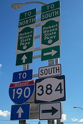 Sign assembly at the then-northern terminus of NY 384 in 2006
Past the Scajaquada, NY 384 continues in a straight northward course trending slightly westward through outlying regions of the city and into the village of Kenmore, where it becomes the main street. North of Kenmore, it crosses the busy Sheridan Drive (NY 324) and then Interstate 290 (the Youngmann Expressway). It then narrows to two lanes and enters the city of Tonawanda. At the north end of the city it reaches Tonawanda Creek and crosses the county line.
Niagara County
In North Tonawanda, Niagara County, NY 384 joins with NY 265 and becomes Main Street, then River Road as the two highways run along the Niagara River after NY 429 splits off. The overlap ends just short of the North Grand Island Bridge, with NY 384 continuing along the riverside as it provides the southernmost Niagara County exit for Interstate 190 Officially, this interchange is also where NY 324 ends.
NY 384 enters the city of Niagara Falls as Buffalo Avenue, intersecting NY 61 at the eastern edge of downtown. Farther west, the route splits from Buffalo Avenue and continues onto Rainbow Boulevard, passing the site of the old Nabisco-owned Shredded Wheat plant ahead of an intersection with the southern segment of the Robert Moses State Parkway. At the intersection, NY 384 turns north onto John B. Daly Boulevard, following the street to its terminus at Niagara Street. NY 384 turns west onto Niagara to access downtown Niagara Falls. There, it intersects the western terminus of NY 104 at First Street and the Rainbow Bridge at Rainbow Boulevard. Instead of continuing to the bridge, NY 384 terminates at the intersection.
History
In 1908, the New York State Legislature created Route 30, an unsigned legislative route extending across New York from Niagara Falls northeast to Rouses Point.[4] By 1914, the definition of Route 30 was modified to include the portion of River Road and Main Street between the Niagara Falls city line and Island Street in North Tonawanda.[5] This addition to Route 30 was removed on March 1, 1921.[6] When the first set of posted routes in New York were assigned in 1924, none of the former North Tonawanda extension of Route 30 was assigned a designation.[7]
NY 384 was assigned as part of the 1930 renumbering of state highways in New York to the primary riverside roadway between the cities of Buffalo and Niagara Falls. It began at Niagara Square in downtown Buffalo and followed Niagara Street north to the city of Tonawanda. From there, NY 384 followed Main Street into North Tonawanda, joining the former routing of Route 30 at Island Street. While Route 30 ended at the Niagara Falls city line, NY 384 continued west along Buffalo Avenue into downtown.[1][8] Ca. 1935, the portion of Delaware Avenue and Grove Street from NY 324 in Kenmore to NY 384 in Tonawanda was designated as NY 266.[8][9]
The alignments of NY 266 and NY 384 south of North Tonawanda were flipped ca. 1936. However, unlike NY 266, NY 384 continued south on Delaware Avenue into downtown Buffalo, where it ended at Niagara Square as it had before.[8][10] NY 384 was rerouted slightly by 1948 to follow Delaware Avenue through Tonawanda and across the Erie Canal to the modern junction of Main and Webster Streets, where it rejoined its previous alignment.[11] The route was extended south through Niagara Square to its current terminus at NY 5 by 1970.[12]
Niagara Falls
In Niagara Falls, NY 384 originally broke from Buffalo Avenue at 10th Street to follow Erie Avenue and Falls, Main,[13] and Niagara Streets to the Niagara River, where it connected to the Honeymoon Bridge (replaced by the Rainbow Bridge in 1941) leading to Niagara Falls, Ontario.[citation needed] NY 384 was truncated by 1938 to the junction of Main and Niagara Streets following the assignment of U.S. Route 104, which followed Niagara Street to the bridge instead.[13] In the 1970s, construction of the Niagara Falls Convention Center—which was built at the junction of Falls Street and Erie Avenue—severed NY 384's routing through the city. As a result, NY 384 was rerouted west of Quay Street (an arterial street connecting to the Robert Moses State Parkway) to follow Rainbow Boulevard through the southwestern portion of the city to NY 104 (Main Street).[14][15][16]
Rainbow Boulevard was made up of what had been Union Avenue and First Street as well as a new north–south street constructed in the vicinity of Main Street.[16][17] The new roadway and First Street served as a one-way couplet for NY 384: the new street became Rainbow Boulevard South and carried NY 384 southbound while First Street was renamed Rainbow Boulevard North and carried NY 384 northbound. Union Avenue, meanwhile, became a four-lane, two-way divided highway. At Quay Street (John B. Daly Boulevard), the Rainbow Boulevard name continued southeast over former Erie Avenue to Buffalo Avenue.[15][18]
In December 2005, construction began on a project to convert the Rainbow Boulevard one-way couplet into dual-direction streets. As part of the project, the location where the dual-direction Rainbow Boulevard split into the parallel streets was turned into a roundabout while the name of Rainbow Boulevard North reverted back to First Street. Rainbow Boulevard South, meanwhile, became Rainbow Boulevard.[19] Work was completed on the conversion of both streets by August 2007, at which time NY 384 was rerouted onto John P. Daly Boulevard and Niagara Street through downtown to a new terminus at the Rainbow Bridge.[20][21] John P. Daly Boulevard was originally designated as NY 952B while the portion of Niagara Street west of 5th Street was originally part of NY 951A;[22] both unsigned reference route designations are unchanged as of 2009 despite the fact that both now overlap the signed NY 384 designation for part of their routing.[2][23]
Major intersections
County Location Mile[2][3] Destinations Notes Erie Buffalo 0.00 NY 5 east0.52 NY 5 west3.71  NY 198
Interchange Kenmore 6.88  NY 324
Town of Tonawanda 7.90 I-290Exit 1 (I-290) Niagara North Tonawanda 10.34  NY 265 south
Southern terminus of NY 265 / NY 384 overlap 10.74  NY 429
Southern terminus of NY 429 Niagara Falls 15.84 NY 265 northNorthern terminus of NY 265 / NY 384 overlap 16.04  LaSalle Expressway west
Interchange; access via Cayuga Drive 17.62  I-190 / Thruway / Robert Moses Parkway north / LaSalle Expressway east
Exit 21 (I-190) 19.10  NY 61
NY 61Southern terminus of NY 61  NY 104
Western terminus of NY 104 21.73 Rainbow Boulevard / Rainbow Bridge 1.000 mi = 1.609 km; 1.000 km = 0.621 mi References
- ^ a b Standard Oil Company of New York (1930). Road Map of New York (Map). Cartography by General Drafting.
- ^ a b c "2008 Traffic Volume Report for New York State" (PDF). New York State Department of Transportation. June 16, 2009. pp. 223–224, 275–276. https://www.nysdot.gov/divisions/engineering/technical-services/hds-respository/NYSDOT%20TVR%202008%20by%20Route.pdf. Retrieved January 30, 2010.
- ^ a b Yahoo! Inc. Yahoo! Maps – segment of NY 384 from 5th Street to John B. Daly Boulevard (Map). Cartography by NAVTEQ. http://maps.yahoo.com/#mvt=m&lat=43.088632&lon=-79.05458&zoom=18&q1=43.088693%2C-79.052534&q2=43.088521%2C-79.056621. Retrieved April 9, 2009.
- ^ State of New York Department of Highways (1909). The Highway Law. Albany, New York: J. B. Lyon Company. p. 64. http://books.google.com/books?id=jZ0AAAAAMAAJ&printsec=frontcover#PPA64,M1. Retrieved May 22, 2009.
- ^ State of New York Commission of Highways (1919). The Highway Law. Albany, New York: J. B. Lyon Company. p. 83. http://books.google.com/books?id=hZ4AAAAAMAAJ&printsec=frontcover#PPA83,M1. Retrieved May 22, 2009.
- ^ New York State Legislature (1921). "Tables of Laws and Codes Amended or Repealed". Laws of the State of New York passed at the One Hundred and Forty-Fourth Session of the Legislature. Albany, New York: J. B. Lyon Company. pp. 42, 64–66. http://books.google.com/books?id=6pE4AAAAIAAJ&pg=PA42. Retrieved June 6, 2010.
- ^ "New York's Main Highways Designated by Numbers". The New York Times: p. XX9. December 21, 1924.
- ^ a b c Shell (1935). Niagara Falls and Vicinity (Map). Cartography by H.M. Gousha Company. http://www.ontarioroadmaps.ca/Oil_Companies/Shell/1935/Niagara.jpg. Retrieved April 9, 2009.
- ^ Texas Oil Company (1934). Road Map of New York (Map). Cartography by Rand McNally and Company.
- ^ Standard Oil Company (1936). New York (Map). Cartography by General Drafting.
- ^ United States Geological Survey (1948). Tonawanda Quadrangle – New York (Map). 1:62,500. 15-Minute Series (Topographic). http://docs.unh.edu/NY/tonw48sw.jpg. Retrieved May 22, 2009.
- ^ State of New York Department of Transportation (January 1, 1970) (PDF). Official Description of Touring Routes in New York State. http://www.greaternyroads.info/pdfs/state70.pdf. Retrieved April 9, 2009.
- ^ a b Thibodeau, William A. (1938). The ALA Green Book (1938–39 ed.). Automobile Legal Association.
- ^ Esso (1968). New York (Map). Cartography by General Drafting (1969–70 ed.).
- ^ a b Exxon (1977). New York (Map). Cartography by General Drafting (1977–78 ed.).
- ^ a b United States Geological Survey (1980). Niagara Falls Quadrangle – New York – Ontario (Map). 1:25,000. 7.5 Minute Series (Topographic). http://www.nysgis.state.ny.us/gisdata/quads/drg24/usgspreview/index.cfm?code=l43079a1. Retrieved April 9, 2009.
- ^ Wagner & Debes (1894). Niagara Falls (Map). 1:31,000. http://www.broermapsonline.org/members/NorthAmerica/UnitedStates/Midatlantic/NewYork/NiagaraFalls/niagara_falls_1894.html. Retrieved April 9, 2009.
- ^ MapArt. Niagara Falls (Map) (1995 ed.).
- ^ New York State Department of Transportation. "NY Route 384 (Rainbow Boulevard)". https://www.nysdot.gov/regional-offices/region5/projects/ny-route-384. Retrieved April 9, 2009.
- ^ New York State Department of Transportation (October 2004) (PDF). Official Description of Highway Touring Routes, Scenic Byways, & Bicycle Routes in New York State. https://www.nysdot.gov/divisions/operating/oom/transportation-systems/repository/tour_route_0.pdf. Retrieved April 9, 2009.
- ^ New York State Department of Transportation (October 2007). Official Description of Highway Touring Routes, Bicycling Touring Routes, Scenic Byways, & Commemorative/Memorial Designations in New York State.
- ^ "Niagara County traffic counts" (PDF). New York State Department of Transportation. 2003. https://www.nysdot.gov/divisions/engineering/technical-services/hds-respository/niagaratvbk.pdf. Retrieved April 9, 2009.
- ^ New York State Department of Transportation (January 2009) (PDF). Official Description of Highway Touring Routes, Bicycling Touring Routes, Scenic Byways, & Commemorative/Memorial Designations in New York State. https://www.nysdot.gov/divisions/operating/oom/transportation-systems/repository/2009%20tour-bk.pdf. Retrieved July 16, 2009.
External links
Categories:- Transportation in Buffalo, New York
- Transportation in Erie County, New York
- Transportation in Niagara Falls, New York
- Transportation in Niagara County, New York
- State highways in New York


Wikimedia Foundation. 2010.