- Cyclone Monica
-
Severe Tropical Cyclone Monica Category 5 cyclone (Australian scale) Category 5 Tropical cyclone (SSHS) 
Severe Tropical Cyclone Monica near peak intensity Formed 17 April 2006 Dissipated 26 April 2006 Highest winds 10-minute sustained:
250 km/h (155 mph)
1-minute sustained:
285 km/h (180 mph)
Gusts:
360 km/h (225 mph)Lowest pressure 916 mbar (hPa; 27.05 inHg)
(Disputed)Fatalities None Reported Damage $5.1 million (2006 USD) Areas affected Australia Part of the 2005–06 Australian region cyclone season Severe Tropical Cyclone Monica was the most intense tropical cyclone, in terms of maximum sustained winds, on record to impact Australia. The 17th storm of the 2005–06 Australian region cyclone season, Monica originated from an area of low pressure off the coast of Papua New Guinea on 16 April. The storm quickly developed into a Category 1 cyclone the next day, at which time it was given the name Monica. Travelling towards the west, the storm intensified into a severe tropical cyclone before making landfall in Far North Queensland, near the Lockhart River, on 19 April. After moving over land, convection associated with the storm quickly became disorganised.
On 20 April, Monica emerged into the Gulf of Carpentaria and began to re-intensify. Over the following few days, deep convection formed around a 37 km (23 mi) wide eye. Early on 22 April, the Bureau of Meteorology (BoM) assessed Monica to have attained Category 5 status, on the Australian cyclone intensity scale. The Joint Typhoon Warning Center (JTWC) also upgraded Monica to a Category 5 equivalent cyclone, on the Saffir–Simpson Hurricane Scale. The storm attained its peak intensity the following day with winds of 250 km/h (155 km/h 10-minute winds) and a barometric pressure of 916 mbar (hPa; 27.05 inHg). On 24 April, Monica made landfall about 35 km (22 mi) west of Maningrida, at the same intensity. Rapid weakening took place as the storm moved over land. Less than 24 hours after landfall, the storm had weakened to a tropical low. The remnants of the former-Category 5 cyclone persisted until 28 April over northern Australia.
In contrast to the extreme intensity of the cyclone, relatively little structural damage resulted from it. No injuries were reported to have occurred during the storm's existence and losses were estimated to be A$6.6 million (US$5.1 million). However, severe environmental damage took place. In the Northern Territory, an area about 7,000 km2 (4,300 mi2) was defoliated by Monica's high wind gusts. In response to the large loss of forested area, it was stated that it would take several hundred years for the area to reflourish.
Contents
Meteorological history
 Storm path
Severe Tropical Cyclone Monica originated from an area of low pressure that formed early on 16 April off the coast of Papua New Guinea.[1] The low quickly became organised, with deep convection developing over the low-pressure centre. Later that day, the Joint Typhoon Warning Center (JTWC) issued a Tropical Cyclone Formation Alert as the system became increasingly organised.[2] Early the next day, the Bureau of Meteorology in Brisbane, Australia declared that the low had developed into a Category 1 cyclone on the Australian tropical cyclone scale, with winds reaching 65 km/h (40 mph 10-minute sustained).[3] Upon being classified as a cyclone, the storm was given the name Monica. At the same time, the JWTC designated Monica as Tropical Cyclone 23P.[4] Monica tracked generally westward, towards Far North Queensland, in response to a low to mid-level ridge to the south.[5]
Low wind shear and good divergence in the path of the storm allowed for continued intensification as continued westward.[6] Late on 17 April, Monica intensified into a Category 2 Cyclone, with winds reaching 95 km/h (60 mph 10-minute sustained).[1][3] By 1200 UTC on 18 April, the Bureau of Meteorology upgraded Monica to a severe tropical cyclone, a Category 3 on the Australian scale.[3] This followed an increase in the storm's outflow and a fluctuating central dense overcast.[7] Several hours later, the JTWC upgraded Monica to the equivalent of a Category 1 hurricane on the Saffir–Simpson Hurricane Scale.[4] During the afternoon of 19 April, the storm made landfall roughly 40 km (25 mi) south-southeast of the Lockhart River with winds of 130 km/h (80 mph 10-minute sustained).[1][3] At the same time, the JTWC assessed Monica to have intensified into a Category 2 equivalent storm with winds of 155 km/h (100 mph 1-minute sustained).[4]
Shortly after making landfall, convection associated with the storm deteriorated and the outflow became fragmented. A shortwave trough to the south caused the ridge steering Monica to weaken, leading to the cyclone moving slower.[8] After moving over land, the storm began to weaken, with the Bureau of Meteorology downgrading the storm to weaken to Category 1 cyclone[3] and the JTWC downgraded the cyclone to a tropical storm.[4] The following day, Monica moved offshore, entering the Gulf of Carpentaria. Once back over water, favourable atmospheric conditions allowed the storm to quickly intensify.[1] Within 24-hours of moving over water, Monica re-attained severe tropical cyclone status.[3] Following a shift in steering currents, the storm slowed significantly and turned north-westward.[1][9] Steady intensification continued through 22 April as the storm remained in a region of low wind shear and favourable diffluence.[10] Early on 22 April the Bureau of Meteorology upgraded Monica to a Category 5 severe tropical cyclone, the third of the season.[1][3] By this time, a 37 km (23 mi) wide eye had developed within the central dense overcast of the cyclone.[11] Later that day, the JTWC assessed Monica to have intensified into a Category 5 equivalent storm.[4]
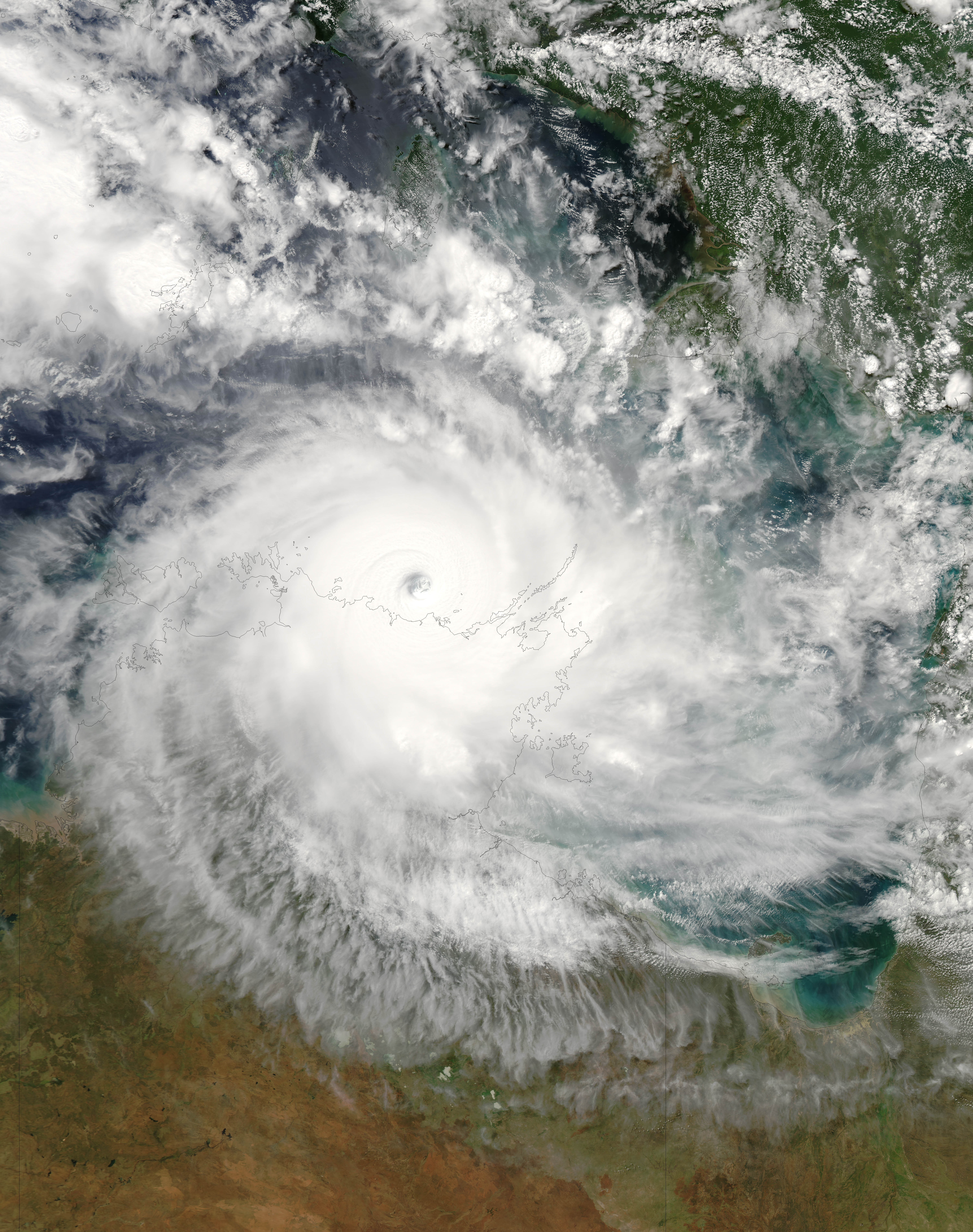
 Satellite image of Cyclone Monica near the Wessel Islands
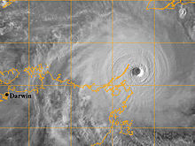
Cyclone Monica attained its peak intensity on 23 April near Cape Wessel with a barometric pressure 916 mbar (hPa; 27.05 inHg). Maximum winds were estimated at 250 km/h (155 mph 10-minute sustained) by the Bureau of Meteorology[1][3] while the JTWC assessed it to have attained winds of 285 km/h (180 mph 1-minute sustained).[4] Using the dvorak technique, the peak intensity of the cyclone was estimated over 320 km/h (200 mph) along with a minimum pressure below 869 mbar (hPa; 25.66 inHg). At its peak, Monica exceeded a T# of 8.0, the highest ranking on the Dvorak Scale.[12] However, since the JTWC is not the official warning centre for Australian cyclones, these intensities remain unofficial.[13]
On 24 April, the mid-level ridge south of Monica weakened, causing the storm to turn towards the south-west.[11] Following this, the storm made landfall in the Northern Territory, roughly 35 km (22 mi) west of Maningrida, as a Category 5 cyclone with winds of 250 km/h (155 mph 10-minute sustained).[1] Not long after making landfall, the storm weakened extremely quickly. Most convective activity associated with the storm dissipated within nine hours of moving onshore. This resulted in the storm's maximum winds decreasing by 155 km/h (100 mph) in a 12-hour span.[3] After this rapid weakening, the storm turned sharply west moving over the town of Jabiru as a Category 2 cyclone. Within six hours of passing this town, the Bureau of Meteorology downgraded Monica to a tropical low, no longer producing gale-force winds.[1] The JTWC issued their final advisory on the storm at 1800 UTC that day.[14] The remnants of Monica persisted for several more days, tracking near Darwin on 25 April before turning south-east and accelerating over the Northern Territory. The remnants eventually dissipated on 28 April over central Australia.[1]
The Bureau of Meteorology uses 10-minute sustained winds, while the Joint Typhoon Warning Center uses one-minute sustained winds.[15][16] The Bureau of Meteorology's peak intensity for Monica was 250 km/h (155 mph) 10-minute sustained, or 285 km/h (180 mph) one-minute sustained.[3][16] The JTWC's peak intensity for Monica was 285 km/h (180 mph) one-minute sustained, or 250 km/h (155 mph) 10-minute sustained.[4][16]
Preparations and impact
Queensland
Upon being declared as Tropical Cyclone Monica on 17 April, the Bureau of Meteorology issued a gale warning for areas along the eastern coast of Far North Queensland.[5] Several hours later, a hurricane warning was issued for north-eastern areas as the storm intensified.[17] An estimated 1,000 people were planned to be evacuated in Far North Queensland before officials shut down major highways in the area. Ferry services in the Great Barrier Reef and flights in and out of the region were cancelled.[18] However, no evacuations took place according to the Emergency Management in Australia.[19] An aborigine community of 700, located around the mouth of the Lockhart River, were in the direct path of the storm. The chief executive officer of the community stated that they were ready for the storm, having suffered no losses from Cyclone Ingrid which impacted the same area in 2005.[20]
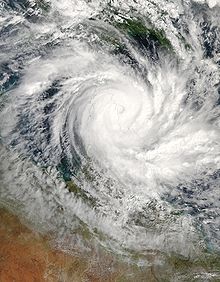 Cyclone Monica making landfall in Far North Queensland
Little damage was recorded in Queensland, despite Cyclone Monica being a Category 3 cyclone, as the storm impacted a sparsely populated region of the Cape York peninsula.[19] A storm surge of 1.23 m (4 ft) was recorded in Mossman and waves were recorded up to 4.24 m (13.91 ft) in Weipa.[21] Heavy rainfall was also associated with the storm, exceeding 400 mm (16 in) near where Monica made landfall. Wind gusts up to 109 km/h (68 mph) were recorded as the storm traversed the peninsula.[1] Officials reported about 15% of the structures along the Lockhart River sustained minor damages and no fatalities were caused as a result of the cyclone.[19] Minor coastal flooding was also reported due to Monica.[21] Three Torres Strait Islanders were rescued after 22 days drifting at sea in the wake of the cyclone passing through the Torres Strait, north of mainland Queensland.[22]
Northern Territory
Officials closed schools throughout the region in advance of the storm on 24 April and advised people to evacuate. A 10 pm curfew was also put in place to keep people off the streets during the night.[23] Local tours in the territory were postponed or cancelled due to the storm. Several flights in and out of Darwin were also cancelled, as was the Darwin Anzac Day march.[24][25] Alcan, the world's second-largest aluminium producer, warned customers of potential interruptions to supplies on contracts from its Gove refinery.[26] Rio Tinto's Ranger Uranium Mine ceased operations on 24 April, "as a precautionary measure".[27]
At one point, Monica was forecast to pass directly over Goulburn Island. In response, officials evacuated the island's 337 residents to shelters set up in Pine Creek. Numerous schools in the threatened region, especially in Darwin, were closed ahead of Monica's arrival.[28] Several shelters were opened in Darwin early on 24 April in anticipation of an influx of evacuees. Stores throughout the area reported increased sales for storm supplies, with some reducing prices on specific items.[29] The same day, the Darwin Returned and Services League of Australia cancelled all ANZAC Day services and marches in Darwin that were to be held the next day, to ensure the safety of prospective participants.[30]
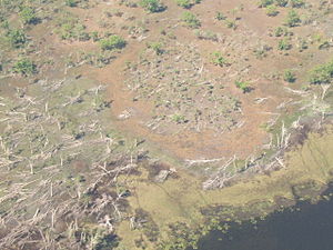 Deforestation due to Cyclone Monica
The Wessel Islands, located off the coast of the region, suffered significant damage from the storm. Mangrove trees were uprooted throughout the islands and sand dunes were destroyed. An outstation located on one of the islands was destroyed by the cyclone.[31] The highest 24-hour rainfall from the storm was recorded near Darwin at 340 mm (13 in).[1] A storm total for the same area was recorded at 383 mm (15.1 in), surpassing the rainfall record for the entire month of April set in 1953.[32] Although the storm made landfall at peak intensity in Australia's Northern Territory, the impacted areas were sparsely populated. Around the region where Monica made landfall, evidence of a 5–6 m (16.4–19.6 ft) storm surge was present in Junction Bay.[19] Along an area 50 km (31 mi) wide and 130 km (81 mi) long, countless trees were snapped or uprooted by the storm.[33] Nearly 70% of the forested areas around the bay were destroyed or defoliated by the storms' 360 km/h (225 mph) wind gusts.[19] An estimated 7,000 km2 (4,350 mi2) of trees were downed by the storm with large areas of trees being uprooted.[34]
Power lines were felled by high winds in Maningrida, 12 homes sustained damage from fallen trees in Jabiru, and extensive damage was reported in Oenpelli.[19] Roughly 1,000 people also lost phone service in the region.[28] Several highways were blocked by fallen trees throughout the area.[19] A resort in Jabiru sustained significant damage and was closed for two weeks following the storm.[24] Insured damages to the national parks amounted to A$1.6 million (US$766,000).[35] According to the Northern Territory Insurance Office, structural damage from Cyclone Monica amounted to A$5 million (US$4.4 million).[36] The remnants of Monica produced significant rainfall over parts of the Northern Territory several days after the system weakened below cyclone status. Flash flooding was reported throughout the Adelaide River basin as up to 261 mm (10.3 in) of rain fell in a 24-hour span.[1] On 26 April, the remnants of Monica spawned a small tornado near Channel Point; several mangrove trees were snapped and branches were thrown to nearby beaches.[37]
Aftermath and records
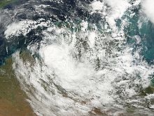 The remnants of Monica on 26 April
The Queensland Government State Disaster Management Group dispatched relief helicopters to remote communities for evacuation of people in flood zones and transport of relief workers.[19] Relief efforts were already underway in relation to Cyclone Larry which caused significant damage in Queensland. The Government of Australia assisted affected business by providing disaster loans up to A$25,000 for severely impacted areas and A$10,000 for less affected areas. Farmers were also provided with up to $200,000 in loans over a period of nine years.[38] Following the impacts in the Northern Territory, two cleanup teams were dispatched from Darwin to assist in cleanup efforts in the hardest hit regions.[19] In a study of the Arnhem forests which were devastated by the cyclone, environmentalists reported that it would take over 100 years for the forest to recover. The storm's winds snapped numerous trees, estimated to have been over 200 years old and more than 60 cm (23.6 in) in diameter. It is estimated that it would take several hundred years before trees of similar sizes would flourish in the region.[39] Despite the minimal damage caused by Monica, the name was retired from the circulating lists of tropical cyclone names for the Australian Region.[40]
Within weeks of the storm, the Alligator Rivers Region Advisory Committee began planting seedlings in deforested areas. By August 2006, a review of the growth of the new plants found that 81% to 88% of the seeds had survived and begun growing. To fully restore the South Alligator valley, environmentalists requested A$7.4 million (US$6.6 million) in funds.[41] In a study at Magela Creek a year after the storm, it was determined that between 8% and 19% of the tree canopy lost due to the storm had begun to recover.[42] Additional studies at the Gulungul Creek and the Alligator Rivers region revealed that suspended sediment values in flowing water had temporarily increased in the wake of Monica. The above-average values persisted for roughly a year before the streams returned to pre-cyclone sediment levels.[43]
Upon making landfall on 24 April, Monica became the strongest known storm to impact the Northern Territory on record.[32] Maximum sustained winds were estimated at 250 km/h (155 mph 10-minute sustained) by the Bureau of Meteorology[1] and 285 km/h (180 mph 1-minute sustained) by the JTWC.[4] According to the JTWC, Monica had a minimum barometric pressure of 879 hPa (mbar), ranking Monica as the strongest storm recorded in the southern hemisphere alongside Cyclone Zoe of 2002.[4][44] Additionally, using the Dvorak technique, the peak intensity of the cyclone was estimated over 320 km/h (200 mph) along with a minimum pressure below 869 hPa (mbar). At its peak, Monica exceeded a T# of 8.0, the highest ranking on the Dvorak Scale. Although unofficial, this would make Monica the strongest known tropical cyclone in history, eclipsing Typhoon Tip of 1979.[12]
See also
- 2005–06 Australian region cyclone season
- Cyclone Larry - An intense tropical cyclone that struck Australia less than a month prior to Monica
- List of the most intense tropical cyclones
References
- ^ a b c d e f g h i j k l m n Staff Writer (2006). "Severe Tropical Cyclone Monica". Bureau of Meteorology. http://www.bom.gov.au/announcements/sevwx/nt/nttc20060417.shtml. Retrieved 22 December 2009.
- ^ Joint Typhoon Warning Center (16 April 2006). "Tropical Cyclone Formation Alert". Unisys Weather. http://weather.unisys.com/hurricane/archive/0604/06041618. Retrieved 23 December 2009.
- ^ a b c d e f g h i j "Australian Region Tropical Cyclone Best Tracks". Bureau of Meteorology. 2009. http://www.bom.gov.au/cgi-bin/silo/cyclones.cgi. Retrieved 23 December 2009.
- ^ a b c d e f g h i "Cyclone 23S Best Track". Joint Typhoon Warning Center. 2007. http://www.usno.navy.mil/NOOC/nmfc-ph/RSS/jtwc/best_tracks/2006/2006s-bsh/bsh232006.txt. Retrieved 22 December 2009.
- ^ a b Joint Typhoon Warning Center (17 April 2006). "Tropical Cyclone 23P Warning 001". Unisys Weather. http://weather.unisys.com/hurricane/archive/0604/06041700. Retrieved 23 December 2009.
- ^ Joint Typhoon Warning Center (17 April 2009). "Tropical Cyclone 23P". Unisys Weather. http://weather.unisys.com/hurricane/archive/0604/06041712. Retrieved 23 December 2009.
- ^ "High Seas Warning". Bureau of Meteorology. Unisys Weather. 18 April 2006. http://weather.unisys.com/hurricane/archive/0604/06041812. Retrieved 23 December 2009.
- ^ Joint Typhoon Warning Center (19 April 2006). "Cyclone 23P Warning 006". http://weather.unisys.com/hurricane/archive/0604/06041912. Retrieved 23 December 2009.
- ^ Joint Typhoon Warning Center (21 April 2006). "Cyclone 23P Advisory 009". http://weather.unisys.com/hurricane/archive/0604/06042100. Retrieved 23 December 2009.
- ^ Joint Typhoon Warning Center (21 April 2006). "Cyclone 23P Advisory 010". Unisys Weather. http://weather.unisys.com/hurricane/archive/0604/06042112. Retrieved 23 December 2009.
- ^ a b Gary Padgett (6 August 2006). "Monthly Tropical Weather Summary for April 2006". Australia Severe Weather. http://www.australiasevereweather.com/cyclones/2006/summ0604.htm. Retrieved 23 December 2009.
- ^ a b "Advanced Dvorak Technique Intensity listing for Cyclone Monica". Cooperative Institute for Mesoscale Meteorological Studies. 2006. http://cimss.ssec.wisc.edu/tropic/adt/archive2006/23P-list.txt. Retrieved 22 December 2009.
- ^ Chris Landsea (2010). "What regions around the globe have tropical cyclones and who is responsible for forecasting there?". National Hurricane Center. http://www.aoml.noaa.gov/hrd/tcfaq/F1.html. Retrieved 27 November 2010.
- ^ Joint Typhoon Warning Center (24 April 2006). "Cyclone 23P Advisory 017 (Final)". Unisys Weather. http://weather.unisys.com/hurricane/archive/0604/06042418. Retrieved 23 December 2009.
- ^ "Frequently Asked Questions". Joint Typhoon Warning Center. 2005. http://www.usno.navy.mil/JTWC/frequently-asked-questions-1. Retrieved 23 December 2009.
- ^ a b c "Section 2 Intensity Observation and Forecast Errors". United States Navy. 2009. http://www.nrlmry.navy.mil/~chu/chap6/se200.htm. Retrieved 23 December 2009.
- ^ "High Seas Warning". Bureau of Meteorology. Unisys Weather. 17 April 2006. http://weather.unisys.com/hurricane/archive/0604/06041706. Retrieved 23 December 2009.
- ^ AAP (19 April 2006). "Monica threatens Cairns with floods". Melbourne: The Age. http://www.theage.com.au/news/national/monica-threatens-cairns-with-floods/2006/04/19/1145344158646.html. Retrieved 25 March 2009.
- ^ a b c d e f g h i Staff Writer (16 September 2006). "Tropical Cyclone Monica". Emergency Management Australia. http://www.ema.gov.au/ema/emadisasters.nsf/83edbd0553620d8cca256d09001fc8fd/4445261b533ebb1eca2571bd0023bcef?OpenDocument. Retrieved 25 March 2009.
- ^ Associated Press (19 April 2006). "Cyclone Monica makes landfall in Australia; no reports of injuries or damage". USA Today. http://www.usatoday.com/weather/storms/2006-04-19-australia-cyclone_x.htm. Retrieved 25 March 2009.
- ^ a b "Tropical Cyclone Monica". Emergency Management Australia. 18 May 2006.
- ^ Staff Writer (10 May 2006). "Torres Strait sea rescue an 'act of God'". Melbourne: The Age. http://www.theage.com.au/news/National/Torres-Strait-sea-rescue-an-act-of-God/2006/05/10/1146940598926.html. Retrieved 23 December 2009.
- ^ Staff Writer (24 April 2006). "Island communities brace for Monica". ABC News. http://www.abc.net.au/cgi-bin/common/printfriendly.pl?http://www.abc.net.au/news/newsitems/200604/s1621996.htm. Retrieved 25 March 2009.
- ^ a b Staff Writer (26 April 2006). "Sigh of relief as Cyclone Monica leaves minimal damage". Travel Weekly.
- ^ "Darwin Battens Down for Monica Hell Storm Targets City". The Cairns Post: p. 5. 25 April 2006.
- ^ Macdonald-Smith, Angela (23 April 2006). "Tropical cyclone Monica threatens Australia's northern coast". Bloomberg L.P.. http://www.bloomberg.com/apps/news?pid=10000081&sid=a.BR4z3if15Y&refer=australia. Retrieved 23 December 2009.
- ^ Associated Press (24 April 2006). "Australia Braces For Major Cyclone". CBS News. http://www.cbsnews.com/stories/2006/04/24/world/main1535625.shtml. Retrieved 23 December 2009.
- ^ a b Staff Writer (25 April 2006). "Goulburn Island residents heading home after cyclone Monica". ABC Australia. http://www.abc.net.au/news/newsitems/200604/s1623553.htm. Retrieved 23 December 2009.
- ^ Staff Writer (24 April 2006). "Darwin braces for cyclone Monica". ABC Australia. http://www.abc.net.au/news/newsitems/200604/s1622908.htm. Retrieved 23 December 2009.
- ^ Jano Gibson and Dylan Welch (24 April 2006). "Warning: Monica's a monster". The Sydney Morning Herald. http://www.smh.com.au/news/national/cyclone-stops-darwin-anzac-march/2006/04/24/1145730845424.html. Retrieved 23 December 2009.
- ^ Staff Writer (6 July 2006). "Study finds islands suffered brunt of Cyclone Monica". ABC News. http://www.abc.net.au/news/stories/2006/07/06/1680810.htm. Retrieved 25 March 2009.
- ^ a b National Climatic Data Center (2006). "Global Hazards: April 2006". National Oceanic and Atmospheric Administration. http://www.ncdc.noaa.gov/sotc/?report=hazards&year=2006&month=apr#Tropical. Retrieved 22 December 2009.
- ^ Garry D. Cook and Clemence M. A. C. Goyens (6 May 2008). "The impact of wind on trees in Australian tropical savannas: lessons from Cyclone Monica". Austral Ecology (Commonwealth Scientific and Industrial Research Organisation) 33 (4): 462–470. doi:10.1111/j.1442-9993.2008.01901.x.
- ^ Kate Sieper (11 July 2006). "In the wake of Cyclone Monica". ABC News. http://www.abc.net.au/rural/content/2006/s1683500.htm. Retrieved 25 March 2009.
- ^ "Financial and Commonwealth reserves system summaries" (PDF). Government of Australia. 2007. http://www.environment.gov.au/parks/publications/annual/06-07/pubs/financial-summary.pdf. Retrieved 25 March 2009.
- ^ Staff Writer (17 May 2006). "Cyclone Monica insurance claims hit $5m". ABC News. http://www.abc.net.au/news/newsitems/200605/s1640176.htm. Retrieved 26 July 2010.
- ^ Staff Writer (May 2006). "Significant Weather — April 2006" (PDF). Bureau of Meteorology. http://www.bom.gov.au/inside/services_policy/public/sigwxsum/pdf/sigw0406.pdf. Retrieved 26 July 2010.
- ^ Staff Writer (26 May 2006). "Tropical Cyclone Monica". Government of Australia.
- ^ Kate Sieper (25 June 2006). "A 100-year wait to see the Arnhem forests again". ABC News. http://www.abc.net.au/rural/nt/content/2006/s1961143.htm. Retrieved 25 March 2009.
- ^ Staff Writer (2009). "Tropical Cyclone Names". Bureau of Meteorology. Archived from the original on 25 January 2008. http://web.archive.org/web/20080125065757/http://www.bom.gov.au/weather/cyclone/about/cyclone-names.shtml. Retrieved 22 December 2009.
- ^ Various Writers (22 August 2006). "August 2006 Alligator Rivers Region Advisory Committee Meeting Summary" (PDF). Alligator Rivers Region Advisory Committee. http://www.nt.gov.au/pfes/documents/Image/police/publications/annrep/ntpfes_annrep_0506.pdf. Retrieved 26 July 2010.
- ^ Grant W. Staben and Kenneth G. Evans (6 May 2008). "Estimates of tree canopy loss as a result of Cyclone Monica, in the Magela Creek catchment northern Australia". Ecological Society of Australia. http://www3.interscience.wiley.com/journal/119419313/abstract. Retrieved 26 July 2010.
- ^ Various Writers (2010). "ERISS Research Summary 2008-2009" (PDF). Environmental Research Institute of the Supervising Scientist. Department of Environment, Water, Heritage and the Arts. http://www.environment.gov.au/ssd/publications/ssr/pubs/ssr201.pdf. Retrieved 26 July 2010.
- ^ Joint Typhoon Warning Center (2003). "Cyclone 06P Best Track". http://www.usno.navy.mil/NOOC/nmfc-ph/RSS/jtwc/best_tracks/2003/2003s-bsh/bsh062003.txt. Retrieved 12 January 2010.
External links
- World Meteorological Organization
- Australian Bureau of Meteorology
- Joint Typhoon Warning Center (JTWC)
- BoM Report
List of retired Australian cyclone names 1960s 1970s 1980s 1990s 2000s 2010s Categories:- Retired Australian region cyclones
- Category 5 Australian region cyclones


Wikimedia Foundation. 2010.