- Dorset
-
For other uses, see Dorset (disambiguation).
Dorset 
Flag of DorsetMotto of County Council: Who's afear'd 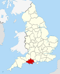
Geography Status Ceremonial & (smaller) Non-metropolitan county Origin Historic Region South West England Area
- Total
- Admin. council
- Admin. areaRanked 20th
2,653 km2 (1,024 sq mi)
Ranked 21st
2,542 km2 (981 sq mi)Admin HQ Dorchester ISO 3166-2 GB-DOR ONS code 19 NUTS 3 UKK22 Demography Population
- Total (2010 est.)
- Density
- Admin. council
- Admin. pop.Ranked 32nd
714,900
265 /km2 (690 /sq mi)
Ranked 27th
404,700Ethnicity 98.1% White Politics 
Dorset County Council
http://www.dorsetforyou.com/Executive Conservative Members of Parliament Districts 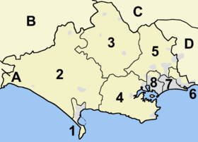
- Weymouth and Portland
- West Dorset
- North Dorset
- Purbeck
- East Dorset
- Christchurch
- Bournemouth (Unitary)
- Poole (Unitary)
Neighbouring counties are (A–D): Devon, Somerset, Wiltshire and Hampshire
Dorset (
 /ˈdɔrsɨt/) (or archaically, Dorsetshire), is a county in South West England on the English Channel coast. The county town is Dorchester which is situated in the south. The Hampshire towns of Bournemouth and Christchurch joined the county with the reorganisation of local government in 1974. The ceremonial county comprises the area covered by the non-metropolitan county, which is governed by Dorset County Council, together with the unitary authorities of Poole and Bournemouth. Dorset is an average sized county with an area of 2,653 square kilometres (1,024 sq mi); it borders Devon to the west, Somerset to the north-west, Wiltshire to the north-east, and Hampshire to the east. Around half of Dorset's population lives in the South East Dorset conurbation. The rest of the county is largely rural with a low population density.
The county has a long history of human settlement and some notable archaeology, including the hill forts of Maiden Castle and Hod Hill. A large defensive ditch, Bokerley Dyke, delayed the Saxon conquest of Dorset for up to 150 years. In 1348 the black death came ashore at Melcombe Regis and subsequently spread throughout England, killing a third of the population. Dorset has seen much civil unrest: the first trade union was formed by farm labourers from Tolpuddle in 1834, the Glorious Revolution was instigated in an ice-house at Charborough Park, and the Duke of Monmouth and his rebels landed at Lyme Regis. During the English Civil War (1642–1651) angry yokels fought with Cromwell's forces near Shaftesbury. The naval base at Portland has had a pivotal role in the nation's defence for many years, and along with Weymouth and Poole was one of the main embarkation points on D-Day.
Initially agricultural, tourism is now the primary industry, with the county receiving 18 million visitors a year. Over half the county is designated as an Area of Outstanding Natural Beauty. Dorset is famous for the Jurassic Coast World Heritage Site, which features landforms such as Lulworth Cove, the Isle of Portland, Chesil Beach and Durdle Door, as well as the holiday resorts of Bournemouth, Poole, Weymouth, Swanage, and Lyme Regis. Dorset's three large ports at Poole, Weymouth and Portland, and its international airport at Hurn, play an important part in the local economy, generating a substantial amount of international trade and tourism. Dorset is the birthplace and principal setting of the novels of Thomas Hardy, who was born in the county, and William Barnes, whose poetry celebrates and preserves the ancient Dorset dialect.
Contents
History
Main article: History of DorsetThe first human visitors to Dorset were Mesolithic hunters, from around 8000 BC.[1] The first permanent Neolithic settlers appeared around 3000 BC.[2] Their populations were small and concentrated along the coast in the Isle of Purbeck, the Isle of Portland, Weymouth and Chesil Beach and along the Stour valley.[1][3] These populations used tools and fire to clear these areas of some of the native oak forest.[3] Further clearances took place in the Bronze Age, making way for agriculture and animal husbandry,[4] Dorset's high chalk hills have provided a location for defensive settlements for millennia. There are Neolithic and Bronze Age burial mounds on almost every chalk hill in the county along with a number of Iron Age hill forts.[5] Probably the most famous of these structures is Maiden Castle, which was built around 600BC and is one of the largest Iron Age hill forts in Europe.[6][7]
Dorset has Roman artefacts, particularly around the Roman town Dorchester, where Maiden Castle was captured from the Celtic Durotriges by a Roman Legion in 43 AD under the command of Vespasian, early in the Roman occupation.[8][9] The Romans also had a presence on the Isle of Portland, constructing - or adapting - hilltop defensive earthworks on Verne Hill.[10] A large ditch and embankment, Bokerley Dyke, enabled the county's post-Roman inhabitants to successfully defend against invading Saxon forces, thereby delaying their conquest of Dorset for up to 150 years.[11] By the end of the 7th century however, Dorset had become part of the Saxon kingdom of Wessex.[12][13] The Domesday Book documents many Saxon settlements corresponding to modern towns and villages and there have been few changes to the parishes since.[12][14] Many monasteries were also established, which were important landowners and centres of power.[15]
In the 12th-century civil war, Dorset was fortified by the construction of the defensive castles at Corfe Castle, Powerstock, Wareham and Shaftesbury, and the strengthening of the monasteries such as at Abbotsbury.[16] The 12th and 13th centuries saw much prosperity in Dorset and the population grew substantially as a result.[17] In order to provide the extra food required, additional land was enclosed for farming during this time.[17] The quarrying of Purbeck Marble, a limestone that can be polished, brought wealth into the county and provided employment for stonecutters and masons. The trade continued until the 15th century when alabaster from Derbyshire became popular.[18] During the Middle Ages, Dorset was used by the monarchy and nobility for hunting and the county still retains a number of deer parks.[19][20] Melcombe Regis, now part of Weymouth, was a busy port at this time and it was in July 1348 that a ship from the continent brought with it the bubonic plague. The residents of Melcombe were the first casualties of a disease, more commonly known as the black death, which went on to wipe out a third of the population of the country.[21]
The Tudor period and the dissolution of the monastries saw the end of many of Dorset's abbeys including Shaftesbury, Cerne and Milton.[22] In 1588, eight ships from Dorset assisted in the destruction of the Spanish Armada.[23] The flagship San Salvador still lies at the bottom of Studland bay.[23] Sir Walter Raleigh later settled in Sherborne and served as MP for Dorset.[24]
In the 17th-century English Civil War, Dorset had a number of royalist strongholds, such as Portland Castle, Sherborne Castle and Corfe Castle,[25] the latter two being ruined by Parliamentarian forces in the war.[26] Corfe had already been successfully defended against an attack in 1643 but an act of betrayal during a second siege in 1646 led to its capture and subsequent slighting.[27] The residents of Lyme Regis were staunch Parliamentarians who, in 1644, repelled three attacks by a Royalist army under King Charle's nephew, Prince Maurice. Maurice lost 2,000 men in the assaults and his reputation was severely damaged as a result.[28] In 1645 some 5,000 angry civilians, annoyed by the disruption caused by the war, gathered to do battle with Cromwell's forces. Armed only with clubs and farming tools, they were easily chased off.[29]
In 1685, James Scott Monmouth, the illegitimate son of Charles II, and 150 supporters landed at Lyme Regis.[30] After the failed Monmouth Rebellion, the 'Bloody Assizes' took place in Dorchester where over a five day period, Judge Jeffreys presided over 312 cases. 74 were executed; 29 were hanged, drawn and quartered; 175 were deported and many were publicly whipped.[31] In 1686, at Charborough Park, a meeting took place to plot the downfall of James II of England. This meeting was effectively the start of the Glorious Revolution.[32]
During the 18th century the Dorset coast saw much smuggling activity; its coves, caves and sandy beaches provided ample opportunities to slip smuggled goods ashore.[33] The production of cloth was a profitable business in Dorset during the 17th and 18th centuries.[34] The absence of coal in the area however meant that during the Industrial Revolution Dorset was unable to compete and so remained largely rural.[35][36][37] Farming has always been central to the economy of Dorset and the county became the birthplace of the trade union movement when, in 1834, the Tolpuddle Martyrs formed the Friendly Society of Agricultural Labourers, and swore an oath of loyalty to one another.[38][39]
During World War I and II Dorset, located on the English Channel, was important to the Royal Navy. Portland Harbour was for many years the largest man-made harbour in the world, and one of the largest Royal Navy bases.[40] Portland, Weymouth and Poole harbours were the main embarkation points on D-Day.[41] Training for the landings also took place in Dorset, on the long sandy beach at Studland which was chosen because of its similarities to the beaches of Northern France.[42]
George III's holidays in Weymouth during the early part of the 19th century did much to promote Dorset's coast as a tourist destination. Dorset's tourism industry has grown ever since, with the seaside resorts of Bournemouth and Weymouth, the Jurassic Coast and the county's sparsely populated rural areas attracting millions of visitors each year.[43][44] With farming declining across the country, tourism has now edged ahead as the primary revenue-earning sector of the county.[36][44][45]
Settlements
See also: List of places in Dorset
 WeymouthWimborneSome of the larger settlements of Dorset.
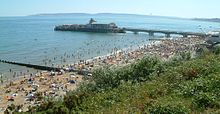
Dorset is largely rural with many small villages, few large towns and no cities.[46][47] The only major urban area is the South East Dorset conurbation, which is situated at the south-eastern end of the county and is atypical of the county as a whole. It consists of the seaside resort of Bournemouth, the historic port and borough of Poole, the towns of Christchurch and Ferndown plus many surrounding villages.[48][49] Bournemouth, the most populous town in the conurbation, was established in the Georgian era when sea bathing became popular.[50] Poole, the second largest settlement (once the largest town in the county), adjoins Bournemouth to the west and contains the suburb of Sandbanks which has some of the highest land values by area in the world.[51] Originally part of neighbouring county Hampshire, Bournemouth and Christchurch were transferred to within Dorset following the reorganisation of local government in 1974.[52]
The other two major settlements in the county are Dorchester, which has been the county town since at least 1305,[53] and Weymouth, a major seaside resort since the 18th century.[54][55] Blandford Forum, Sherborne, Gillingham, Shaftesbury and Sturminster Newton are historic market towns which serve the farms and villages of the Blackmore Vale in north Dorset.[56] Beaminster and Bridport are situated in the west of the county; Verwood and the historic Saxon market towns of Wareham and Wimborne Minster are located to the east.[56] Lyme Regis and Swanage are small coastal towns popular with tourists.[57] Still in construction on the western edge of Dorchester is the experimental new town of Poundbury commissioned and co-designed by Prince Charles.[58] The suburb, which is expected to be fully completed by 2025, was designed to integrate residential and retail buildings and counter the growth of dormitory towns and car-oriented development.[59]
Physical geography
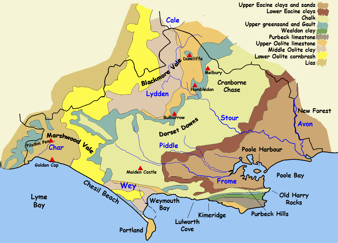
Main article: Geology of DorsetDorset covers an area of 1,024 square miles (2,650 km2) and contains an enormous variety of landscapes determined by the underlying geology.[60][61][62] A large percentage (66%) comprises chalk, clay and mixed sand and gravels but the remainder is much more complex and contains hard rock such as Portland or Purbeck stone, other limestones, calcareous clays and shales.[63] Both Portland and Purbeck stone are of national importance.[64] Almost every type of rock from early Jurassic to the mid-Tertiary period can be found within the county.[65]
Dorset has a large number of limestone downland ridges, mostly covered in either arable fields or calcareous grassland supporting sheep.[66] These limestone areas include a band of chalk which crosses the county from south-west to north-east incorporating Cranborne Chase, the Dorset Downs and Purbeck Hills.[67][68] Between the areas of downland are large, wide clay vales (primarily Oxford Clay with some Weald Clay and London Clay) with wide flood plains.[69] These vales are primarily used for dairy agriculture, dotted with small villages, farms and coppices.[70] They include the Blackmore Vale (Stour valley) and Frome valley.[68][69] South-east Dorset, around Poole and Bournemouth, lies on very non-resistant Eocene clays (mainly London Clay and Gault Clay), sands and gravels.[69] These thin soils support a heathland habitat which sustains all six native British reptile species.[71] In the west of the county the chalk and clay formations, which are typical of much of south-east England, give way to older and more chaotically-arranged strata,[72] and a landscape more akin to that of neighbouring West Country county Devon.[73] Marshwood Vale, a valley of Lower Lias clay at the western tip of the county, lies to the south of the two highest points in Dorset: Lewesdon Hill (279 metres / 915 feet) and Pilsdon Pen (277 metres / 909 feet).[74]
 Geology map of Dorset
A former river valley flooded by rising sea levels 6,000 years ago, Poole Harbour is one of the largest natural harbours in the world.[75][76] The harbour is very shallow in places and contains a number of islands, notably Brownsea Island, the birthplace of the Scouting movement and one of the few remaining sanctuaries for indigenous red squirrels in England.[77] The harbour, and the chalk and limestone hills of the Isle of Purbeck to the south, lie atop Western Europe's largest onshore oil field. The field, operated by BP from Wytch Farm, has the world's oldest continuously pumping well at Kimmeridge (which has been producing oil since the early 1960s); and the longest horizontal drill (8 km/5 mi, ending underneath Bournemouth pier).[78][79]
Dorset's varied geography also ensures it has a variety of rivers, although a modest annual rainfall averaging around 900 mm (35 in), coupled with rolling hills, means most are characteristically lowland in nature.[80] Much of the county drains into three rivers, the Frome, Piddle and Stour which all flow to the sea in a south-easterly direction.[81] The Frome and Piddle are chalk streams but the Stour, which rises in Wiltshire to the north, has its origins in clay soil.[82] The River Avon, which flows mainly through Wiltshire and Hampshire, enters Dorset towards the end of its journey at Christchurch Harbour.[83] The rivers Axe and Yeo, which principally drain the counties of Devon and Somerset respectively, have their sources in the north-west of the county, while in the south-west, a large number of small rivers run into the sea along the Dorset coastline; most notable of these are the Char, Brit, Bride and Wey.[84]
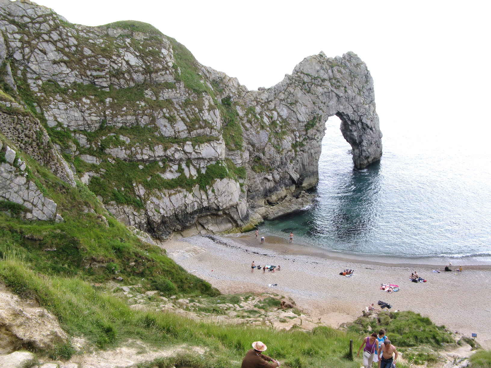
Most of Dorset's coastline is part of the Jurassic Coast, a World Heritage Site noted for its geological landforms.[85] The coast documents the entire Mesozoic era, from Triassic to Cretaceous, and has yielded important fossils, including the first complete Ichthyosaur and fossilised Jurassic trees.[85] The coast also features notable coastal landforms, including textbook examples of a cove (Lulworth Cove) and natural arch (Durdle Door).[86] At the most easterly part of the Jurassic Coast stand the chalk stacks known as Old Harry Rocks, formed over 65 million years ago.[87] Jutting out into the English Channel at roughly the midpoint of the coastline is the Isle of Portland, a limestone island that is connected to the mainland by Chesil Beach, a 17-mile (27 km) long shingle barrier beach protecting Britain's largest tidal lagoon.[88][89]
The county has one of the highest proportion of conservation areas in England—including two Areas of Outstanding Natural Beauty which together cover 53% of the county.[90][91] There is also a World Heritage Site (114 km/71 mi),[92] two Heritage Coasts (92 km/57 mi)[92] and Sites of Special Scientific interest (199.45 km2/49,285 acres).[93] The South West Coast Path, a National Trail, runs along the Dorset coast from the Devon boundary to South Haven Point near Poole.[94]
Climate
Dorset's climate of warm summers and mild winters are due in part to its position on Britain's south coast. The third most southerly county in the UK, Dorset is unaffected by the more intense winds of Atlantic storms that Cornwall and Devon experience. Dorset, along with the south-west, experiences higher winter temperatures (average 4.5 to 8.7 °C or 40 to 48 °F) than the rest of the United Kingdom,[95] while still maintaining higher summer temperatures than that of Devon and Cornwall (average highs of 19.1 to 22.2 °C or 66 to 72 °F).[96] The average annual temperature of the county is 9.8 to 12 °C (50–54 °F), apart from areas of high altitude such as the Dorset Downs.[97]
The south coast counties of Dorset, Hampshire, West Sussex, East Sussex and Kent enjoy more sunshine than anywhere else in the United Kingdom, receiving 1541–1885 hours a year.[98] Average annual rainfall varies across the county—southern and eastern coastal areas receive as little as 741 mm (29.2 in) per year, while the Dorset Downs receive between 1,061 and 1,290 mm (41.7–50.8 in) per year; less than Devon and Cornwall to the west but more than counties to the east.[99]
Demography
Dorset Ethnicity and Religion UK Census 2001 Dorset C.C.[100] Bournemouth UA[101] Poole UA [102] South West[100] England[100] Total population 390,980 163,444 138,288 4,928,434 49,138,831 White 98.75% 96.68% 98.2% 97.71% 90.92% Mixed 0.5% 1.19% 0.67% 0.76% 1.31% Asian 0.25% 0.7% 0.52% 0.67% 4.57% Black 0.15% 0.42% 0.18% 0.43% 2.3% Chinese or Other 0.37% 1.01% 0.43% 0.45% 0.89% Christian 77.88% 70.91% 74.34% 73.99% 71.74% Non Christian 0.99% 3.07% 1.3% 1.48% 5.97% No religion 13.74% 17.94% 16.23% 16.75% 14.59% Not stated 7.39% 8.08% 8.03% 7.79% 7.69% The 2001 census records Dorset's population as 692,712. This consisted of 390,980 for the administrative county plus 163,444 for the unitary authority of Bournemouth and 138,288 for the unitary authority of Poole.[100] In 2009 it was estimated that the population had risen by around 2.5% to 710,100 with 404,000 in the administrative county and 164,900 and 141,200 in Bournemouth and Poole respectively.[103] The South East Dorset conurbation which comprises Poole, Bournemouth and Christchurch contains 62% of the population, with the next largest urban area being Weymouth.[47] The remainder of the county is largely rural with a sparse population.[47]
Dorset's population has a high proportion of older people and a lower than average proportion of young people: 26.7% are of retirement age, significantly higher than the England and Wales average of 19.5%, and 16.8% are less than 15 years old, lower than the England and Wales average of 18.7%.[104] The working age population (females between 16 and 59 and males between 16 and 64) is lower than average at 56.5%.[104] Average life expectancy within the county is 83.4 years for females and 79.3 years for males. This compares favourably with the averages for Great Britain of 81.6 and 77.3 years respectively.[105] Around 97.93% of Dorset's population are of white ethnicity, 74.38% of the population are Christian and 15.94% say they are not religious.[106][107][108]
The administrative county (not including Bournemouth and Poole) has one of the lowest birth rates of the 34 shire English counties, at 9.1 births per 1000, compared to the England and Wales average of 12.9 per 1000.[109] It has a slightly higher than average mortality rate at 11.5 deaths per 1,000 population (9.0 for England and Wales).[109] In 2009 deaths exceeded births by 946, however in 2007–08 there was a net influx of 3,000 migrants giving an overall growth in the size of Dorset's population of 12.0% between 1991 and 2009 (9.9% for England and Wales). This rate of growth is set to continue with an estimated 12.7% population growth between 2008 and 2033.[109] The unitary authorities of Bournemouth and Poole followed a similar pattern, with only a net gain of migrants preventing a decline in the population.[110][111] However, in Bournemouth in 2007, births began to exceed deaths and in 2009 there were 295 more births than deaths.[110] Between 1998 and 2004 Poole borough experienced a decline in its population caused by continuing negative rates of natural increase and falls in the level of net migration.[111] The trend has since been reversed and a continued increase in Poole's population has been predicted.[112]
Historical population of Dorset Year 1801 1811 1821 1831 1841 1851 1861 1871 1881 1891 1901 Population 101,857 112,930 129,210 143,443 161,617 169,699 174,255 178,813 183,371 188,700 188,263 Year 1911 1921 1931 1941 1951 1961 1971 1981 1991 2001 2011 Population 190,940 193,543 198,105 214,700 233,206 259,751 292,811 321,676 366,681 390,986 - Pre-1974 statistics were gathered from local government areas that now comprise Dorset
Source: Great Britain Historical GIS.[113]Politics
Local government in Dorset consists of a county council (Dorset County Council) and two unitary authorities (Bournemouth Borough Council and Poole Borough Council). Dorset County Council was created by the Local Government Act 1888 to govern the newly created administrative county of Dorset which was based largely on the historic county borders. In 1974 Dorset became a two-tier non-metropolitan county and its border was extended eastwards to incorporate the former Hampshire towns of Bournemouth and Christchurch. Following a review by the Local Government Commission for England, Bournemouth and Poole both became administratively independent single-tier unitary authorities in 1997, although they remain part of the county geographically and for ceremonial purposes. The county council is based in Dorchester and comprises six second-tier districts: West Dorset, East Dorset, North Dorset, Purbeck, Christchurch and Weymouth and Portland. It is controlled by the Conservative Party: at the 2009 local elections 28 Conservative, 16 Liberal Democrat and one independent county councillors were elected.[114] Bournemouth is also Conservative-controlled: the council comprises 46 Conservative, three Liberal Democrat, three Labour and two independent councillors.[115] The Conservatives lost overall control of Poole at local elections in 2011 but subsequently formed a minority administration—the council comprises 21 Conservative councillors, 18 Liberal Democrat and three Poole People (a political party of Poole residents).[116]
For representation in Parliament Dorset is divided into eight Parliamentary constituencies — five county constituencies and three borough constituencies. At the 2010 general election, the Conservative Party was dominant, strengthening their lead in six seats, and regaining one other from Labour.[117] The borough constituencies of Bournemouth East, Bournemouth West and Poole are traditionally Conservative safe seats and are all represented by Conservative Members of Parliament.[118] The county constituencies of North Dorset and Christchurch are also represented by Conservative MPs. West Dorset is represented by Conservative MP Oliver Letwin who is the Minister for Government Policy. The marginal seat of South Dorset is represented by Richard Drax, who gained the seat from Dorset's only Labour representative, Jim Knight, in 2010.[117][119] Mid Dorset and North Poole is held by Liberal Democrat MP Annette Brooke who retained her seat in 2010 with a slim majority of 269 (0.6% of the vote) over the Conservative candidate.[120] For the European Parliament the county lies within the South West England constituency which elected three Conservative, two UK Independence Party and one Liberal Democrat Members of the European Parliament (MEPs) at the 2009 European Parliament election.[121]
Economy and industry
Dorset's employment structure (2008)[A] Industry Dorset C.C.[122] Poole UA[123] Bournemouth UA[124] Great Britain[122] Manufacturing 11.9% 15.8% 3.2% 10.2% Construction 5.3% 4.6% 3.2% 4.8% Services 81.5% 79% 93.1% 83.5% Tourism-related[B] 10.2% 7.7% 12% 8.2% A.^ Excludes self-employed, government-supported trainees and armed forces
B.^ Includes industries that are also part of the services industryIn 2003 the gross value added (GVA) for the administrative county was £4,673 million, with an additional £4,705 million for Poole and Bournemouth.[125] 2.03% of GVA was produced by primary industry, 22.44% from secondary industry and 75.53% from tertiary industry.[125] The average GVA for the 16 regions of South West England was £4,693 million.[125] The GVA per resident is £38,900 for the administrative county, £43,000 for Poole and Bournemouth, £42,500 for the South West and £44,900 for the UK.[126]
The principal industry in Dorset was once agriculture. It has not, however, been the largest employer for many decades as mechanisation has substantially reduced the number of workers required.[45][127] Agriculture has become less profitable and the industry has declined further. Within the administrative county between 1995 and 2003, GVA for primary industry (largely agriculture with some fishing and quarrying) declined from £229 to 188 million—7.1% to 4.0%.[125] In 2007, 2,039 km2 (787 sq mi) of the county was in agricultural use, up from 1,986 km2 (767 sq mi) in 1989, although this was due to an increase in permanent grass and land set aside.[128] By contrast, in the same period, arable land decreased from 9,925 km2 (3,832 sq mi) to 9,157 km2 (3,536 sq mi).[128] Excluding fowl, sheep is currently the most common animal stock in the county, between 1989 and 2006 their numbers fell from 252,189 to 193,500. Cattle and pig farming has declined similarly, during the same period the number of cattle fell from 240,413 to 170,700, and the number of pigs from 169,636 to 72,700.[129]
In 2009 there were 3,190 armed forces personnel stationed in Dorset [130] including, the Royal Armoured Corps at Bovington,[131] Royal Signals at Blandford[132] and the Royal Marines at Poole.[133] The military presence has had a mixed effect on the local economy bringing additional employment for civilians but on occasion having a negative impact on the tourist trade, particularly when popular areas are closed due to military manoeuvres.[134][135] Recent plans to relocate the Royal School of Signals to South Wales could result in a loss of up to £74M GVA for the area.[136]
Other major employers in county include; BAE Systems, Sunseeker International, J.P. Morgan, Cobham plc and Bournemouth University.[137] Dorset's three large ports; Poole, Weymouth and Portland, play an important part in the local economy generating a substantial amount of international trade and tourism.[138] The five smaller harbours of Christchurch, Swanage, Lyme Regis, Wareham and West Bay help provide shelter for over 600 local fishing vessels.[138][139] The waters around Weymouth and Portland will be used for the sailing events in the 2012 Olympic Games and as a result the area has already benefitted from an increased investment in infrastructure and a noticeable growth in the marine leisure sector. It is expected that this in turn will have a positive effect on local businesses and tourism.[140]
 Dorset has over 18 million annual visitors and the coast is a major attraction.
Tourism has grown in Dorset since the late 18th century and is now the predominate industry.[141] It is estimated that 37,500 people work in Dorset's tourism sector.[142] 3.2 million British tourists and 326,000 foreign tourists visited the county in 2008, staying a sum total of 15.1 million nights.[143] In addition there were 14.6 million day visitors.[143] The combined spending of both groups was £1,458 million.[143] 56% of Dorset's day trippers visited the towns while 27% went to the coast and 17% to the countryside.[144] A survey carried out in 1997 concluded that the primary reason tourists were drawn to Dorset, was the attractiveness of the county's coast and countryside.[145] Numbers of both domestic and foreign tourists has fluctuated in recent years due to various factors including security and economic downturn, a trend reflected throughout the UK.[146]
Dorset has little manufacturing industry, at 10.3% of employment in 2008. This was slightly above the average for Great Britain but below that of the South West region which was at 10.7% for that period. [122][123][124] The sector is currently the county's fourth largest employer but a predicted decline suggests there will be 10,200 fewer jobs in manufacturing by 2026.[147]
Culture
Main article: Culture of Dorset, England The Keep Military Museum in Dorchester
As a largely rural county, Dorset has fewer major cultural institutions than larger or more densely populated areas. Major venues for concerts and theatre include Poole's Lighthouse arts centre, Bournemouth's BIC, Pavilion Theatre and O2 Academy, Verwood's Hub, Wimborne's Tivoli Theatre, Bridport Arts Centre and the Pavilion theatre in Weymouth.[148] One of Dorset's most noted cultural institutions is the Bournemouth Symphony Orchestra which was founded in 1893.[149] Based in Poole, the orchestra performs over 130 concerts across southern England each year.[150]
Dorset has more than 30 general and specialist museums.[151][152] The Dorset County Museum in Dorchester was founded in 1846 and contains an extensive collection of exhibits covering the county's history and environment.[153] The Tank Museum at Bovington contains over 300 tanks and armoured vehicles from 30 countries.[154] The museum is the largest in Dorset and its collection has been Designated of national importance.[154][155] Other museums which reflect the cultural heritage of the county include The Keep Military Museum in Dorchester, the Russell-Cotes Museum in Bournemouth, the Charmouth Heritage Coast Centre, Poole Museum, Portland Museum and Wareham Town Museum.[152][156]
Dorset contains 190 Conservation Areas, more than 1,500 Scheduled Ancient Monuments, over 30 registered parks and gardens and 12,850 listed buildings, many of which—over 6,000—are in the west of the county.[157][158] Of the 229 that are Grade I listed, 174 are churches or places of worship,[159] from the longest church in England, Christchurch Priory,[160] to one of the smallest, St Edwold's.[161] Nine castles are listed: some were constructed as defensive fortresses such as Corfe, Portland and Christchurch Castle; others are mock castles such as Highcliffe and Lulworth.[159]

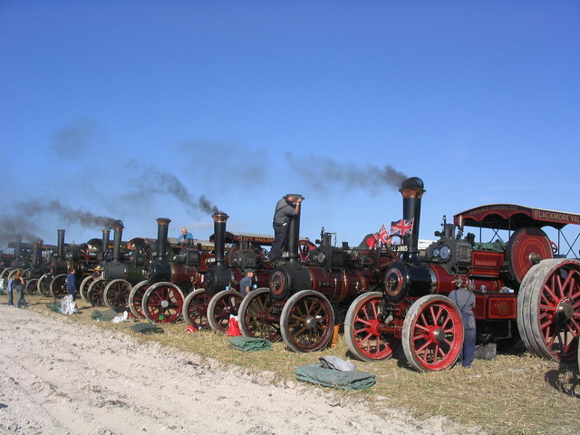
Dorset hosts a number of annual festivals, fairs and events including the Great Dorset Steam Fair near Blandford, one of the largest events of its kind in Europe,[162] and the Bournemouth Air Festival, a free air show that attracted 1.3 million visitors in 2010.[163] The Spirit of the Seas is a maritime festival held in Weymouth and Portland. Launched in 2008, the festival features sporting activities, cultural events and local entertainers.[164] The Dorset County Show, which was first held in 1841, is a celebration of Dorset's relationship with agriculture.[165] The two day event showcases local produce and livestock and attracts some 55,000 people.[165] In addition to the smaller folk festivals held in towns such as Christchurch and Wimborne,[166][167] Dorset holds several larger musical events such as Camp Bestival, Endorse It In Dorset, End of the Road and the Larmer Tree Festival.[168][169][170][171]
Dorset's only Football League club is A.F.C. Bournemouth who play in League One—the third highest division in the English football league system. Non-League semi-professional teams in the county include Conference South team Dorchester Town F.C. and Southern Premier Division team Weymouth F.C.. Dorset County Cricket Club compete in the Minor Counties Cricket Championship and are based at Dean Park Cricket Ground in Bournemouth. Rugby Union is played throughout the county—the Dorset & Wiltshire Rugby Football Union is the constituent body responsible for organising competitions on behalf of the Rugby Football Union (RFU).[172] The county's coastline is noted for its watersports which take advantage of the sheltered waters of Weymouth Bay and Portland Harbour,[173] and Poole Bay and Poole Harbour.[174] Dorset will host the sailing events at the 2012 Summer Olympics and 2012 Summer Paralympics at the Weymouth and Portland National Sailing Academy in Portland Harbour. The venue was completed in May 2009 and will be used by international sailing teams in preparation for the Games.[175][176][177]
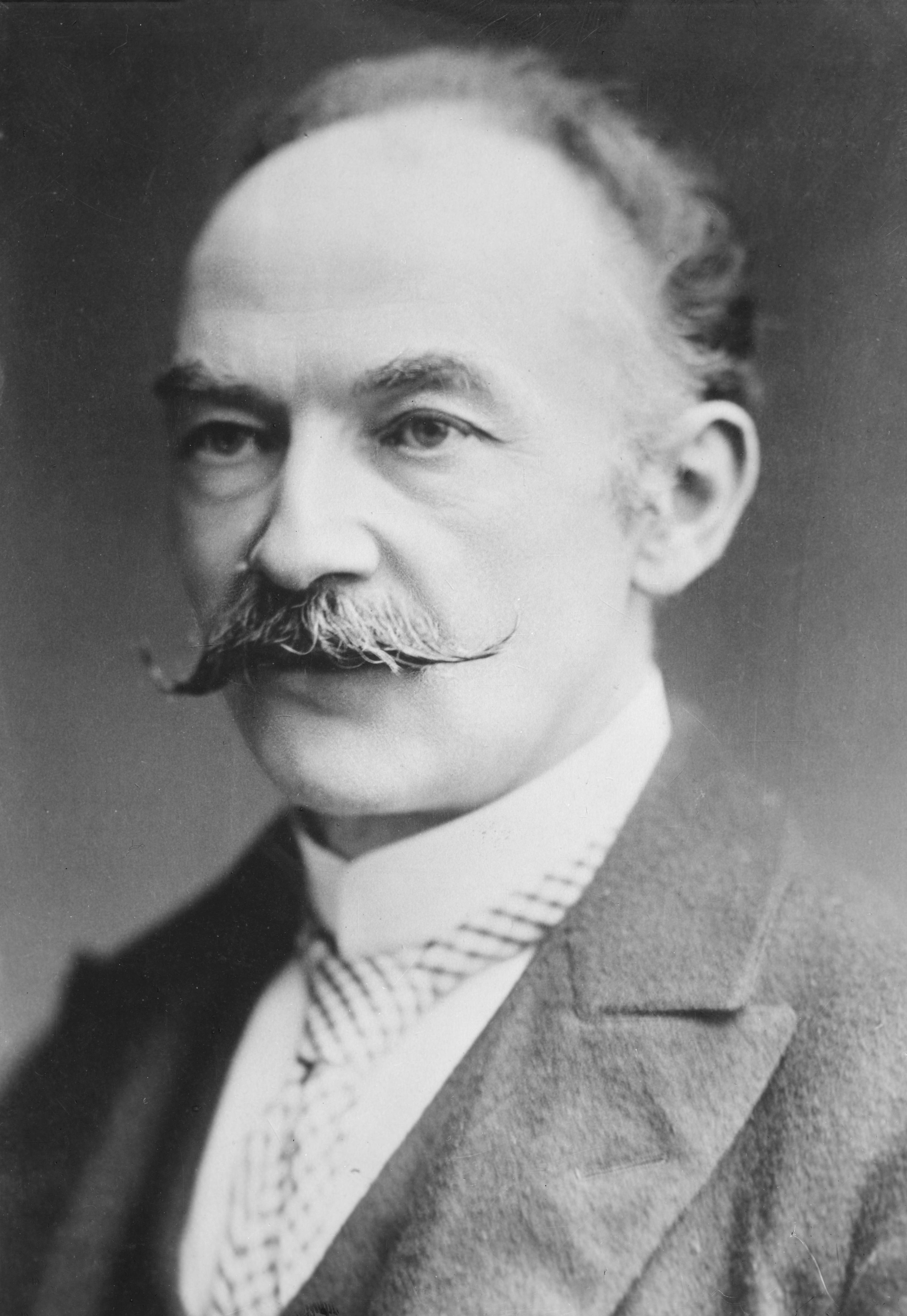
Dorset is famed in literature for being the native county of author and poet Thomas Hardy, and many of the places he describes in his novels in the fictional Wessex are in Dorset, which he renamed South Wessex.[178][179] The National Trust owns Thomas Hardy's Cottage, in Higher Bockhampton, east of Dorchester; and Max Gate, his former house in Dorchester.[180] Several other writers have called Dorset home, including Douglas Adams who wrote much of The Hitchhiker's Guide to the Galaxy while he lived in Stalbridge;[181] Ian Fleming (James Bond) boarded at Durnford School;[182] John le Carré, author of espionage novels;[183] Tom Sharpe of Wilt fame lived in Bridport;[184] John Fowles (The French Lieutenant's Woman) lived in Lyme Regis before he died in late 2005;[185] T.F. Powys lived in Chaldon Herring for over 20 years and used it as inspiration for the fictitious village of Folly Down in his novel Mr. Weston's Good Wine;[186] John Cowper Powys, his elder brother also set a number of his novels in Dorset.[187] The 19th century poet William Barnes was born in Bagber and wrote many poems in his native Dorset dialect.[179] Originating from the ancient Norse and Saxon languages, the dialect has been disappearing since the arrival of the railways and Barnes's poetry is considered an important, historical record.[188]
Dorset's flag, which is known as the Dorset Cross, was adopted in 2008 following a public competition organised by Dorset County Council.[189] The winning design, which features a white cross with a red border on a golden background, attracted 54% of the vote.[190] All three colours are used in Dorset County Council's coat of arms and the red and white was used in recognition of the English flag.[191] The golden colour represents Dorset's sandy beaches and the Dorset landmarks of Golden Cap and Gold Hill. It is also a reference to the Wessex Dragon, a symbol of the Saxon Kingdom which Dorset once belonged to, and the gold wreath featured on the badge of the Dorset Regiment.[191] The flag is often unofficially named St Wite's Cross after a Saxon holy woman buried in Whitchurch Canonicorum who was believed to have been martyred by invading Danes in the 9th century.[191] Dorset's motto is 'Who's Afear'd'.[192]
Transport
Main article: Transport in DorsetDorset is connected to London by two main railway lines. The West of England Main Line runs through the north of the county at Gillingham and Sherborne (there is also a station at Templecombe, just over the Somerset border).[193] Running west to Crewkerne (Somerset) and Axminster (Devon) it provides a service for those who live in the western districts of Dorset.[193] The South Western Main Line runs through the south at Bournemouth, Poole, Dorchester and the terminus at Weymouth.[194] Additionally, the Heart of Wessex Line runs from Weymouth to Bristol and the Swanage Railway, a heritage steam and diesel railway, runs the 6 miles between Norden and Swanage.[195]
Dorset is one of the few counties in England not to have a single motorway.[196] The A303, A35 and A31 trunk roads run through the county.[197] The A303, which connects the West Country to London via the M3, clips the north-west of the county.[198] The A35 crosses the county in an east-west direction from Honiton in Devon, via Dorchester, Poole, Bournemouth and Christchurch, to Southampton in Hampshire. The A31 connects to the A35 at Bere Regis, and passes east through Wimborne and Ferndown to Hampshire, where it later becomes the M27. Other main roads in the county include the A338, A354, A37 and A350. The A338 heads north from Bournemouth to Ringwood (Hampshire) and on to Salisbury (Wiltshire) and beyond. The A354 also connects to Salisbury after traveling north-east from Weymouth in the south of the county. The A37 travels north-west from Dorchester to Yeovil in Somerset. The A350 also leads north, from Poole through Blandford and Shaftesbury, to Warminster in Wiltshire.[198]
There are two passenger sea ports and an international airport in the county. Two ferry services, Brittany Ferries and Condor Ferries, operate out of Poole Harbour. Brittany Ferries provide access to Cherbourg in France, while Condor Ferries sail to Jersey and Guernsey in the Channel Islands; and St Malo, France during the season.[199] Condor Ferries also operate services from Weymouth harbour to Guernsey, Jersey and St. Malo; throughout the year.[200] Both Poole, since the dredging of the main channel in 2008, and Portland harbours are capable of taking cruise liners.[201] Bournemouth Airport is situated on the edge of Hurn village in the Borough of Christchurch, 4 miles (6 km) north of Bournemouth.[202] 17 tour and airline operators fly to more than 30 international destinations.[203] In August 2007 work began on a £32 million expansion programme which includes enlargement of the terminal building and an increase in parking.[204]
Dorset is served by 18 bus operators that take advantage of central and local government grants.[205][206] The Wilts & Dorset bus company has a county wide network with frequent services linking many major towns, and a limited service in a number of more rural locations.[207] The First Group operate buses in the Weymouth and Bridport area, including: A regular route along the A35 from Weymouth to Axminster, which helps to compensate for the missing rail link west of Dorchester; And the Jurassic Coast service, one of the longest bus routes in the UK, which provides through travel from Poole to Exeter, exploiting a popular tourist route.[208][209] Transdev Yellow Buses are the main providers of routes within the South East Dorset Conurbation.[210] Damory Coaches is one of a number of operators that provide access to more rural communities.[211]
Education
See also: List of schools in Dorset, List of schools in Bournemouth, and List of schools in PooleResponsibility for state education in Dorset is divided between three local education authorities: Dorset County Council, which covers majority of the county, and Bournemouth and Poole unitary authorities. Most of the Dorset County Council area operates a two-tier comprehensive system whereby pupils attend a primary school before completing their education at secondary school. Only Dorchester, Ferndown, Wimborne and Purbeck maintain a three-tier system (first, middle and high school),[212] although Purbeck is expected to switch to a two-tier system by 2013 due to an excessive number of surplus school places.[213] Bournemouth operates a two-tier system; Poole operates a three-tier system but will switch to two-tiers from September 2013.[214] Poole and Bournemouth are two of a minority of local authorities in England still to maintain selective education, each containing two single-sex grammar schools which select pupils on the basis of an eleven plus examination. The county also contains six academies—self-governing state schools which have become independent of their local education authority and are maintained directly by the Department for Education.[215] In 2010, 59.4% of pupils attending schools in the county council area gained at least five GCSEs at A*–C grades including English and maths, above the national average of 53.4%.[216] Bournemouth and Poole also recorded above average results at 56.5% and 55.3% respectively.[217][218] However, the majority of non-selective schools in the two unitary authorities fell below the national average.[219]
Dorset contains a range of privately-funded independent schools. Many are boarding schools which also take day pupils such as the co-educational Canford School which is based around a 19th century Grade I listed manor house, St Mary's, a Catholic girls' school in Shaftesbury, and Sherborne School, a boys school founded in the 16th century.[220] Four of the county's five largest towns contain a further education college: Weymouth College, Kingston Maurward College in Dorchester and Bournemouth and Poole College which is one of the largest in the UK.[221] Dorset has two higher education establishments situated in the heart of the county's south east conurbation. Bournemouth University has several facilities across Bournemouth and Poole and over 17,000 students.[222] Previously named Bournemouth Polytechnic, it was granted university status as a result of the Further and Higher Education Act 1992.[222] The Arts University College at Bournemouth is situated between the border of Poole and Bournemouth. It became a higher education institute in 2001 and was given degree-awarding powers in 2008, although its origins go back to 1883.[223]
See also
- Lord Lieutenant of Dorset
- High Sheriff of Dorset
- List of Dorset beaches
- List of Parliamentary constituencies in Dorset
- List of places in Dorset#Places of interest
- List of schools in Dorset
- West Country dialects
Notes
- ^ a b Cullingford (p.13)
- ^ Cullingford (p.14)
- ^ a b "Cultural History". Dorset for You. Dorset County Council. http://www.dorsetforyou.com/339547. Retrieved 24 February 2011.
- ^ "About Dorset's Heaths". Dorset for You. Dorset County Council. http://www.dorsetforyou.com/392502. Retrieved 24 February 2011.
- ^ Cullingford (pp.15&16)
- ^ Cullingford (p.16)
- ^ "Maiden Castle". Pastscape - National monuments Records. English Heritage. 2007. http://www.pastscape.org.uk/hob.aspx?hob_id=451864. Retrieved 12 February 2011.
- ^ Cullingford (p.18)
- ^ "Vespasian (9 AD - 79 AD)". British Broadcasting Corporation. 2007. http://www.bbc.co.uk/history/historic_figures/vespasian.shtml. Retrieved 2 April 2008.
- ^ "Portland, an Illustrated History"; Stuart Morris ISBN 0-946159-34-3
- ^ Cullingford (pp.23-24)
- ^ a b Draper (p142)
- ^ The New Illustrated British History. Prof. Eric J. Evans (editor). London: Starfire. 2001. p. 192. ISBN 1 903817 24 2.
- ^ Cullingford (p.41-43)
- ^ Cullingford (p.46-47)
- ^ Cullingford (p.43)
- ^ a b Cullingford (p48)
- ^ Cullingford (p49)
- ^ "Things to see, do, hear and discover". Dorset for You. Dorset County Council. http://www.dorsetforyou.com/392076. Retrieved 4 March 2011.
- ^ Cullingford (p.86)
- ^ Hilliam (p17)
- ^ Cullingford (p55)
- ^ a b Cullingford (p58)
- ^ Cullingford (p59)
- ^ Cullingford (p.62)
- ^ Cullingford (p.63)
- ^ "Corfe Castle, a brief history.". The National Trust. http://www.nationaltrust.org.uk/main/w-vh/w-visits/w-findaplace/w-corfecastle/w-corfecastle-brief_history.htm. Retrieved 6 July 2011.
- ^ Hillman (pp 143-144)
- ^ Hillman (pp144-145)
- ^ The New Illustrated British History. Prof. Eric J. Evans (editor). London: Starfire. 2001. p. 142. ISBN 1 903817 24 2.
- ^ Cullingford (p71)
- ^ Cullingford (p72)
- ^ Cullingford (pp.87-88)
- ^ Cullingford (p.91)
- ^ Cullingford (pp.91-92)
- ^ a b Draper (p143)
- ^ "Agriculture and Land Use". A Vision of Britain Through Time. Portsmouth University. http://www.visionofbritain.org.uk/data_cube_page.jsp?data_theme=T_LAND&data_cube=N_LAND2001&u_id=10104210&c_id=10001043&add=Y. Retrieved 8 March 2011.
- ^ Hilliam (p10)
- ^ Cullingford (pp.114-116)
- ^ "Local History - Dorset". BBC. http://www.bbc.co.uk/dorset/content/articles/2005/10/06/breakwater_fort_feature.shtml. Retrieved 1 April 2011.
- ^ Cullingford (p.120)
- ^ "BBC Local - Dorset". BBC. http://www.bbc.co.uk/dorset/content/articles/2009/05/18/dday_exercise_smash_feature.shtml. Retrieved 1 April 2011.
- ^ Cullingford (p.92)
- ^ a b Dorset For You. "Tourism in Dorset". Dorset County Council. http://www.dorsetforyou.com/29741. Retrieved 1 April 2011.
- ^ a b "Dorset Census Information Leaflet". Dorset County Council. 2011. p. 3. https://2011mc.census.gov.uk/files/pdf/factsheets/dorset_county_media_pack.pdf. Retrieved 1 April 2011.
- ^ "Bournemouth Bids for Queen's Jubillee City Status". BBC News - Dorset. 25 May 2011. http://www.bbc.co.uk/news/uk-england-dorset-13539202. Retrieved 2 June 2011.
- ^ a b c "Dorset's Minerals Core Strategy". Dorset For You. p. 20. http://www.dorsetforyou.com/media.jsp?mediaid=156450&filetype=pdf. Retrieved 20 April 2011.
- ^ "Joint Study Reports". Dorset for You. http://www.dorsetforyou.com/390949. Retrieved 2 June 2011.
- ^ "South East Dorset Strategy". Bournemouth, Dorset and Poole Partnership. November 2005. p. 2. http://www.dorsetforyou.com/media.jsp?mediaid=90980&filetype=pdf. Retrieved 2 June 2011.
- ^ "History of Bournemouth". Bournemouth Borough Council. http://www.bournemouth.gov.uk/PlanningBuildings/ConservationDesignTrees/Conservation/historyofbournemouth.aspx. Retrieved 4 June 2011.
- ^ "Island on the market for £2.5 million". British Broadcasting Corporation. 13 April 2005. http://news.bbc.co.uk/2/hi/uk_news/england/dorset/4440107.stm. Retrieved 13 April 2005.
- ^ "200 years of the Census in Dorset" (PDF). Office for National Statistics. 2001. http://www.statistics.gov.uk/census2001/bicentenary/pdfs/dorset.pdf. Retrieved 25 August 2009.
- ^ "The Mayor Making Ceremony". Dorchester Town Council. 2007. http://www.dorchester-tc.gov.uk/About+Us/Civic+History/The+Mayoralty/The+Mayor+Making+Ceremony. Retrieved 2 June 2011.
- ^ "Population - Key Facts". Dorset for You. 2009. http://www.dorsetforyou.com/344863. Retrieved 4 June 2011.
- ^ "Weymouth". Dorset for You. 2009. http://www.dorsetforyou.com/343610. Retrieved 4 June 2011.
- ^ a b "Market Towns". Destination Dorset. 2010. http://www.visit-dorset.com/site/explore-dorset/towns/market-towns. Retrieved 4 June 2011.
- ^ "Seaside Towns". Destination Dorset. 2010. http://www.visit-dorset.com/site/explore-dorset/towns/seaside-towns. Retrieved 4 June 2011.
- ^ "Poundbury". The Duchy of Cornwall. http://www.duchyofcornwall.org/designanddevelopment_poundbury.htm. Retrieved 10 August 2009.
- ^ "Poundbury: can Prince Charles change the way we build?". The Daily Telegraph. 15 July 2008. http://www.telegraph.co.uk/news/features/3637310/Poundbury-can-Prince-Charles-change-the-way-we-build.html. Retrieved 2 June 2011.
- ^ "Dorset Data Book". Dorset County Council. 2010. p. 8. http://www.dorsetforyou.com/media.jsp?mediaid=154835&filetype=pdf. Retrieved 7 February 2011.
- ^ Draper (p.136)
- ^ Chaffey (p.5)
- ^ Draper (pp.136–137)
- ^ "Dorset's Minerals Core Strategy" (PDF). Dorset County Council. p. 22. http://www.dorsetforyou.com/media.jsp?mediaid=156450&filetype=pdf. Retrieved 20 April 2011.
- ^ Chaffey (p.9)
- ^ Cullingford (P.91)
- ^ Chaffey (p.43)
- ^ a b Chaffey (p.11)
- ^ a b c "Geology of Britain Viewer". British Geological Survey. http://maps.bgs.ac.uk/geologyviewer_google/googleviewer.html. Retrieved 14 February 2011.
- ^ Chaffey (pp.23–26)
- ^ "Dorset's Heathland Reptiles". Dorset County Council. http://www.dorsetforyou.com/336264. Retrieved 8 April 2011.
- ^ Wightman, R. "PortraitOf Dorset", Hale, 1983, p19
- ^ Wightman, R. "PortraitOf Dorset", Hale, 1983, p10
- ^ Chaffey (p.54)
- ^ "Harbour Masters". Bournemouth Daily Echo. http://www.bournemouthecho.co.uk/news/features/snapshotsofthepast/8721696.Harbour_masters/. Retrieved 12 April 2011.
- ^ "About Us". Poole Harbour Commissioners. http://www.phc.co.uk/about.html. Retrieved 14 February 2011.
- ^ "Nature Conservation and Landscape" (PDF). Poole Harbour Management Plan. Poole Harbour Commissioners. 2006. pp. 1–2. http://www.pooleharbouraqmp.co.uk/pdf/ph_amp2006_Chapter_5.pdf. Retrieved 11 April 2011.
- ^ Cullingford (p.122)
- ^ "BP NSI – Wytch Farm". publisher=BP. http://www.bpnsi.com/index.asp?id=7369643D312669643D313531. Retrieved 8 April 2011.
- ^ Wright (p.7)
- ^ Wright (pp.6–7)
- ^ Wright (pp.7–14)
- ^ Wright (pp.16–17)
- ^ Wright (p.17)
- ^ a b "Jurassic coast is world wonder". BBC News. 13 December 2001. http://news.bbc.co.uk/1/hi/england/1708397.stm. Retrieved 12 August 2009.
- ^ "Path Description - Dorset". South West Footpath Association. http://www.southwestcoastpath.org.uk/aboutthepath/description/dorset/. Retrieved 13 April 2011.
- ^ "Old Harry Rocks". Jurassic Coast World Heritage Site. http://www.jurassiccoast.com/380/the-coast-uncovered-30/geo-highlights-226/old-harry-rocks-the-end-of-the-story-623.html. Retrieved 18 April 2011.
- ^ "Jewels of the Jurassic Coast". West Dorset District Council. http://www.westdorset.com/site/group-travel/itineraries/jurassic-jewels. Retrieved 13 April 2011.
- ^ Chaffey (pp.68–70)
- ^ "Dorset, Bournemouth, Poole Brief". Government Office for South-West. May 2010. p. 1. http://docs.google.com/viewer?a=v&q=cache:0oRQ8JYPO-UJ:www.gosw.gov.uk/497666/docs/220636/309014/dorsstatbrf.doc+dorset+highest+number+of+conservation+areas&hl=en&gl=uk&pid=bl&srcid=ADGEEShrijMGpiFpHlJuUfuMgt5wKct_0oXXB0YnRaZqTqqresYXV7We1_f_6zAqeMIutbpwksNkcyuo4RTwXtSidZEsS-ex7FCJDVhrUPIP6grI7yFTbgjXckROqk95XQNqkDLGGvpP&sig=AHIEtbSUwvIRGQmIJfqHW_h-QyferrDsNw. Retrieved 19 August 2011.
- ^ planning constraints DFY "Planning constraints". Dorset for You. Dorset County Council. http://www.dorsetforyou.com/363371 planning constraints DFY. Retrieved 19 August 2011.
- ^ a b "Length of coastline and coastal designations". Dorset County Council. 2007. http://www.dorsetforyou.com/index.jsp?articleid=332789. Retrieved 25 July 2007.
- ^ "Nature Conservation Designations - SSSIs". Dorset County Council. 2007. http://www.dorsetforyou.com/index.jsp?articleid=332782. Retrieved 25 July 2007.
- ^ "Section: Worth Matravers to South Haven Point". South Western Coastal Path. Natural England. http://www.southwestcoastpath.com/main/sections/index.cfm?fsa=dspSectionDetail&w_id=187. Retrieved 12 April 2011.
- ^ "Mean Temperature Winter Average". Met Office. 2001. http://www.metoffice.gov.uk/climate/uk/averages/19712000/tmean/16.gif. Retrieved 14 August 2007.
- ^ "Maximum Temperature Summer Average". Met Office. 2001. http://www.metoffice.gov.uk/climate/uk/averages/19712000/tmax/14.gif. Retrieved 14 August 2007.
- ^ "Mean Temperature Annual Average". Met Office. 2001. http://www.metoffice.gov.uk/climate/uk/averages/19712000/tmean/17.gif. Retrieved 14 August 2007.
- ^ "Sunshine Duration Annual Average". Met Office. 2001. http://www.metoffice.gov.uk/climate/uk/averages/19712000/ss/17.gif. Retrieved 14 August 2007.
- ^ "Rainfall Amount Annual Average". Met Office. 2001. http://www.metoffice.gov.uk/climate/uk/averages/19712000/rr/17.gif. Retrieved 14 August 2007.
- ^ a b c d "Neighbourhood Statistics - Dorset". Census. Office for National Statistics. 2001. http://neighbourhood.statistics.gov.uk/dissemination/LeadDatasetList.do;jsessionid=ac1f930c30d538126b6c61b04628abed824012c18844?a=3&b=3567699&c=Dorset&d=180&g=438089&i=1001x1003&o=1&m=0&r=1&s=1304074056327&enc=1&domainId=15&nsjs=true&nsck=true&nssvg=false&nswid=1532. Retrieved 29 April 2011.
- ^ "Neighbourhood Statistics - Bournemouth". Census. Office for National Statistics. 2001. http://neighbourhood.statistics.gov.uk/dissemination/LeadDatasetList.do?a=3&b=276839&c=Bournemouth&d=13&g=402507&i=1001x1003&o=1&m=0&r=1&s=1304096116078&enc=1&domainId=15. Retrieved 29 April 2011.
- ^ "Neighbourhood Statistics - Poole". Census. Office for National Statistics. 2001. http://neighbourhood.statistics.gov.uk/dissemination/LeadDatasetList.do?a=3&b=276840&c=Poole&d=13&g=403343&i=1001x1003&o=1&m=0&r=1&s=1304080495695&enc=1&domainId=15. Retrieved 29 April 2011.
- ^ "Current Population – Dorset For You". Dorset County Council. 2007. http://www.dorsetforyou.com/index.jsp?articleid=344105. Retrieved 25 August 2009.
- ^ a b "Dorset Data Book". Dorset For You. 2010. p. 9. http://www.dorsetforyou.com/media.jsp?mediaid=154835&filetype=pdf. Retrieved 20 April 2011.
- ^ "The Low Down (issue 26)". Dorset For You. Feb 2010. p. 15. http://www.dorsetforyou.com/media.jsp?mediaid=143503&filetype=pdf. Retrieved 20 April 2011.
- ^ "Christchurch Borough Profile". Dorset County Council. 2001. http://www.dorsetforyou.com/325672. Retrieved 24 April 2011.
- ^ "Profile of Bournemouth 2001". Bournemouth Borough Council. 2003. p. 3. http://www.bournemouth.gov.uk/Library/PDF/Living/Planning/Research/Bmth%20profile.pdf. Retrieved 24 April 2011.
- ^ "Diversity in Poole". Poole Borough Council. 2011. http://opinions.discussit.co.uk/facts/ref:C46C00D7B6DAEE/category:/. Retrieved 24 April 2011.
- ^ a b c "Keyfacts on Dorset - general". Dorset County Council. 2010. http://www.dorsetforyou.com/index.jsp?articleid=333003. Retrieved 24 April 2011.
- ^ a b "Population Trends in Bournemouth". Bournemouth Borough Council. August 2010. p. 4. http://www.bournemouth.gov.uk/Library/PDF/Living/Planning/Research/THEMES/Population_and_Migration/Population%20Trends%20in%20Bournemouth%202010.pdf. Retrieved 24 April 2011.
- ^ a b "Poole's Population (2004)". Poole Borough Council. p. 2. http://opinions.discussit.co.uk/downloads/assets/Population.pdf. Retrieved 24 April 2011.
- ^ "Poole's Population - Key Issues". Poole Borough Council. http://opinions.discussit.co.uk/downloads/assets/Population_Report_2010.pdf. Retrieved 24 April 2011.
- ^ A Vision of Britain through time. "Dorset Modern (post 1974) County: Total Population". http://www.visionofbritain.org.uk/data_cube_page.jsp?data_theme=T_POP&data_cube=N_TOT_POP&u_id=10104210&c_id=10001043&add=N. Retrieved 10 January 2010.
- ^ "Dorset county council local election 2009". The Daily Telegraph. 18 May 2009. http://www.telegraph.co.uk/news/politics/local-elections/5278896/Dorset-county-council-local-election-2009.html. Retrieved 9 June 2011.
- ^ "Full list of councillors". Bournemouth Borough Council. 2011. http://www.bournemouth.gov.uk/CouncilDemocracy/Councillors/CouncillorsandCommittees.aspx. Retrieved 9 June 2011.
- ^ "Conservatives to run Poole as minority administration". BBC News. 13 May 2011. http://www.bbc.co.uk/news/uk-england-dorset-13387838. Retrieved 9 June 2011.
- ^ a b "Labour's Jim Knight loses Dorset South seat to Tories". BBC News. 7 May 2010. http://news.bbc.co.uk/1/hi/uk_politics/election_2010/england/8660695.stm. Retrieved 9 June 2011.
- ^ "Election 2010: Which are the safest seats in Britain?". The Guardian. 7 April 2010. http://www.guardian.co.uk/politics/interactive/2010/apr/07/general-election-2010. Retrieved 9 June 2011.
- ^ "David Cameron struggles to banish party’s toff image". The Times. 28 March 2010. http://www.timesonline.co.uk/tol/news/politics/article7078861.ece. Retrieved 9 June 2011.
- ^ "Dorset Mid and Poole North". The Guardian. 2010. http://www.guardian.co.uk/politics/constituency/1121/dorset-mid-and-poole-north. Retrieved 9 June 2011.
- ^ "Your MEPs". UK Office of the European Parliament. 2009. http://www.europarl.org.uk/section/your-meps/findmep?filter0=South+West&filter1=**ALL**&filter2=**ALL**&filter3=**ALL**&filter4=**ALL**. Retrieved 9 June 2011.
- ^ a b c "Labour Market Profile Dorset". Office for National Statistics. https://www.nomisweb.co.uk/reports/lmp/la/1967128585/report.aspx?town=Dorset#tabempocc. Retrieved 20 May 2011.
- ^ a b "Labour Market Profile Poole". Office for National Statistics. https://www.nomisweb.co.uk/reports/lmp/la/2038431918/report.aspx?town=poole. Retrieved 20 May 2011.
- ^ a b "Labour Market Profile Bournemouth". Office for National Statistics. https://www.nomisweb.co.uk/reports/lmp/la/2038431914/report.aspx?town=Bournemouth. Retrieved 20 May 2011.
- ^ a b c d "Regional Gross Value Added (p249)" (PDF). Office for National Statistics. 2003. http://www.statistics.gov.uk/downloads/theme_economy/RegionalGVA.pdf. Retrieved 14 August 2007.
- ^ "Economy - Key Facts". Dorset for You. Dorset County Council. http://www.dorsetforyou.com/345037. Retrieved 7 February 2011.
- ^ "Historical Statistics - Industry". A Vision of Britain Through Time. Portsmouth University. http://www.visionofbritain.org.uk/data_cube_page.jsp?data_theme=T_IND&data_cube=N_INDUSTRY_GEN&u_id=10104210&c_id=10001043&add=Y. Retrieved 26 April 2011.
- ^ a b "Area under crops and grass, 1989-2007". Dorset For You. 2007. http://www.dorsetforyou.com/332783. Retrieved 26 April 2011.
- ^ "Livestock 1989-2007". Dorset For You. 2007. http://www.dorsetforyou.com/332785. Retrieved 26 April 2011.
- ^ "Military Presence and Economic Significance in the South West Region". Wiltshire County Council. March 2009. p. 23. http://www.wiltshire.gov.uk/military-in-the-south-west.pdf. Retrieved 7 May 2011.
- ^ "Armour Centre, Bovington". British Army. http://www.army.mod.uk/training_education/training/16131.aspx. Retrieved 6 May 2011.
- ^ "11 (RSS) Sig Regt". British Army. http://www.army.mod.uk/signals/organisation/8596.aspx. Retrieved 6 May 2011.
- ^ "Royal Navy Listings". Defence Suppliers Directory. http://www.armedforces.co.uk/navy/listings/l0038.html. Retrieved 6 May 2011.
- ^ "Fears for 4000 jobs at army base". Dorset Echo. 18 January 2007. http://www.thisisdorset.net/news/1130925.fears_for_4_000_jobs_at_army_base/. Retrieved 6 May 2011.
- ^ "Military Activity". Dorset Coast Forum. pp. 2&3. http://www.dorsetforyou.com/media/pdf/5/f/Topic_Paper_Military.pdf. Retrieved 6 May 2011.
- ^ "Military Presence and Economic Significance in the South West Region". Wiltshire County Council. March 2009. p. 9. http://www.wiltshire.gov.uk/military-in-the-south-west.pdf. Retrieved 7 May 2011.
- ^ "Invest in Dorset - Economy". Bournemouth, Dorset and Poole Economic Partnership. http://www.investindorset.co.uk/economy.html. Retrieved 3 May 2011.
- ^ a b "Coastal Economy". Dorset for You. http://www.dorsetforyou.com/21037. Retrieved 3 May 2011.
- ^ "Fishing". Dorset for You. http://www.dorsetforyou.com/21142. Retrieved 3 May 2011.
- ^ "Weymouth and Portland Economic and Tourism Development Strategy" (PDF). Weymouth and Portland Borough Council. p. 14. http://media.weymouth.gov.uk/docstore/Tourism/POL_20200205_StratConsult.pdf. Retrieved 4 May 2011.
- ^ "Tourism" (PDF). Dorset Coastal Forum. p. 1. http://www.dorsetforyou.com/media.jsp?mediaid=8835&filetype=pdf. Retrieved 9 May 2011.
- ^ "Tourism" (PDF). Dorset Coastal Forum. p. 3. http://www.dorsetforyou.com/media.jsp?mediaid=8835&filetype=pdf. Retrieved 9 May 2011.
- ^ a b c "The Value of Tourism 2008". VoT 2008 - 4 Dorset and Districts 2008 (page 1). South West Tourism. http://www.swtourismalliance.org.uk/documents/q/category/finance-facts-figures-documents/value-of-tourism-archive/value-of-tourism-2008/. Retrieved 13 May 2011.
- ^ "The Value of Tourism 2008". VoT 2008 - 4 Dorset and Districts 2008 (page 7). South West Tourism. http://www.swtourismalliance.org.uk/documents/q/category/finance-facts-figures-documents/value-of-tourism-archive/value-of-tourism-2008/. Retrieved 13 May 2011.
- ^ "Tourism" (PDF). Dorset Coastal Forum. p. 4. http://www.dorsetforyou.com/media.jsp?mediaid=8835&filetype=pdf. Retrieved 13 May 2011.
- ^ "UK Tourism Lowest for 7 years". The Institute of Commercial Management. http://news.icm.ac.uk/business/uk-tourism-lowest-for-7-years/2726/. Retrieved 8 August 2009.
- ^ "Bournemouth Dorset Poole Workspace Strategy and Delivery Plan" (PDF). South West Regional Development Agency. 2008. p. 78. http://www.boroughofpoole.com/downloads/assets/FINAL_ISSUED_BDP_Workspace~for_web.pdf. Retrieved 18 May 2011.
- ^ "Cinemas and theatres". Dorset for You. http://www.dorsetforyou.com/2802. Retrieved 21 May 2011.
- ^ "Cultural Strategy". Dorset for You. 2010. http://www.dorsetforyou.com/culturalstrategy. Retrieved 21 May 2011.
- ^ "Orchestra". Bournemouth Symphony Orchestra. http://www.bsolive.com/orchestra. Retrieved 25 August 2009.
- ^ "Dorset Museums". Dorset for You. http://www.dorsetforyou.com/museums. Retrieved 23 May 2011.
- ^ a b "Find a Museum". Dorset for You. http://www.dorsetforyou.com/323007. Retrieved 23 May 2011.
- ^ "Dorset County Museum". Dorset For You. http://www.dorsetforyou.com/323069. Retrieved 23 May 2011.
- ^ a b "Plaques presented to military museums with outstanding Designated collections". Culture24. 8 October 2009. http://www.culture24.org.uk/history+%26+heritage/war+%26+conflict/art72596. Retrieved 30 May 2011.
- ^ "They're on a roll!". Bristol Evening Post. 28 March 2009. http://www.thisisbristol.co.uk/news/roll/article-849723-detail/article.html. Retrieved 30 May 2011.
- ^ "Dorset Cultural Strategy 2009-2014". Dorset Strategic Partnership. p. 15. http://www.dorsetforyou.com/media.jsp?mediaid=139307&filetype=pdf. Retrieved 23 May 2011.
- ^ "Culture Brings Us Together". Dorset For You. http://www.dorsetforyou.com/367886. Retrieved 27 May 2011.
- ^ "Listed Buildings DCC". Dorset For You. http://www.dorsetforyou.com/listedbuilding. Retrieved 26 May 2011.
- ^ a b "Grade 1 Listed Buildings in Dorset". British Listed Buildings. http://www.britishlistedbuildings.co.uk/england/dorset/I. Retrieved 26 May 2011.
- ^ Moxey, Sarah (1997). Avon Valley Footpath Guide. Wellington: Halsgrove. p. 87. ISBN 9781874448266.
- ^ Kinross, John (2003). Discovering England's smallest churches. London: Wiedenfeld & Nicholson. pp. 39–40. ISBN 1842127284.
- ^ "The Great Dorset Steam Fair". BBC. 2005. http://www.bbc.co.uk/dorset/content/articles/2006/03/15/great_dorset_steam_fair_feature.shtml. Retrieved 29 May 2011.
- ^ "Weather affects last day of air show". BBC News - Dorset. 22 August 2010. http://www.bbc.co.uk/news/uk-england-dorset-11053021. Retrieved 28 May 2011.
- ^ "Spirit of the Sea festival". BBC. 2009. http://www.bbc.co.uk/dorset/content/articles/2008/02/28/spirit_of_the_sea_feature.shtml. Retrieved 29 May 2011.
- ^ a b "Dorset County Show". BBC News - Dorset. 1 September 2009. http://news.bbc.co.uk/local/dorset/hi/people_and_places/arts_and_culture/newsid_8231000/8231473.stm. Retrieved 28 May 2011.
- ^ "Christchurch Music Festival". Visit Dorset - What's On. Destination Dorset. 2010. http://www.visit-dorset.com/site/whats-on/christchurch-music-festival-p598313. Retrieved 28 May 2011.
- ^ "Wimborne Folk Festival". Visit Dorset - What's On. Destination Dorset. 2010. http://www.visit-dorset.com/site/whats-on/wimborne-folk-festival-p383013. Retrieved 28 May 2011.
- ^ "Camp Bestival". Visit Dorset - What's On. Destination Dorset. 2010. http://www.visit-dorset.com/site/whats-on/camp-bestival-p647753. Retrieved 28 May 2011.
- ^ "Endorse It". Visit Dorset - What's On. Destination Dorset. 2010. http://www.visit-dorset.com/site/whats-on/endorse-it-in-dorset-p634303. Retrieved 28 May 2011.
- ^ "End of the Road Festival". The Independent - Reviews. Destination Dorset. 15 September 2009. http://www.independent.co.uk/arts-entertainment/music/reviews/end-of-the-road-festival-larmer-tree-gardens-dorset-1787308.html. Retrieved 28 May 2011.
- ^ "Larmer Tree Festival". Visit Dorset - What's On. Destination Dorset. 2010. http://www.visit-dorset.com/site/whats-on/larmer-tree-festival-p383763. Retrieved 28 May 2011.
- ^ "Dorset & Wilts RFU (CB)". Rugby Football Union. http://clubs.rfu.com/Clubs/portals/dw/. Retrieved 25 August 2009.
- ^ "Water Sports and Water Activities in Weymouth and Portland, Dorset UK". Weymouth and Portland Borough Council. http://www.visitweymouth.co.uk/index.php?resource=22. Retrieved 25 August 2009.
- ^ "Poole Tourism Things To Do". Poole Tourism. http://www.pooletourism.com/go.php?structureID=thingstodo&ref=&category=C4A36677CE51A1&x=29&y=11. Retrieved 25 August 2009.
- ^ "2012 work completed at WPNSA". Royal Yachting Association. 2009. http://www.rya.org.uk/newsevents/news/Pages/2012sailingvenueofficially.aspx. Retrieved 10 August 2009.
- ^ "Sailing rivals use Olympic venue". BBC News. 10 August 2009. http://news.bbc.co.uk/1/hi/england/dorset/8193246.stm. Retrieved 10 August 2009.
- ^ "First 2012 Olympic venue unveiled". BBC News. 28 November 2008. http://news.bbc.co.uk/1/hi/england/dorset/7753734.stm. Retrieved 30 September 2009.
- ^ Blamires pp.112–114.
- ^ a b "Dorset's writers and explorers". BBC News. 22 July 2009. http://news.bbc.co.uk/local/dorset/hi/people_and_places/arts_and_culture/newsid_8158000/8158886.stm. Retrieved 30 May 2011.
- ^ "Special Places to Visit - Dorset". The National Trust. http://www.nationaltrust.org.uk/main/w-global/w-localtoyou/w-wessex/w-wessex-places_visit/w-wessex-places-otherspecialplaces.htm. Retrieved 22 May 2011.
- ^ "Up Kilimanjaro with the Adams Family". BBC Dorset. 24 August 2005. http://www.bbc.co.uk/dorset/content/articles/2005/08/24/adams_rhino_feature.shtml. Retrieved 30 May 2011.
- ^ Britten, Nick (30 October 2008). "Ian Fleming 'used 16th century spy as inspiration for James Bond'". The Daily Telegraph. http://www.telegraph.co.uk/news/uknews/3285886/Ian-Fleming-used-16th-century-spy-as-inspiration-for-James-Bond.html. Retrieved 30 May 2011.
- ^ "John le Carré". The Guardian. 30 March 2011. http://www.guardian.co.uk/books/2011/mar/30/john-le-carre-profile. Retrieved 30 May 2011.
- ^ "Welcome to Bridport, or Notting Hill on Sea". The Daily Telegraph. 17March 2007. http://www.telegraph.co.uk/property/3357164/Welcome-to-Bridport-or-Notting-Hill-on-Sea.html. Retrieved 30 May 2011.
- ^ Blamires p.88.
- ^ Blamires p.225.
- ^ Drabble, Margaret (12 August 2006). "The English degenerate". The Guardian (London). http://www.guardian.co.uk/books/2006/aug/12/featuresreviews.guardianreview14. Retrieved 11 August 2009.
- ^ "Dorset Dialect of William Barnes". Dorset Echo. 4 May 2011. http://www.dorsetecho.co.uk/news/9006358.Dorset_dialect_of_William_Barnes/. Retrieved 29 May 2011.
- ^ "Dorset Cross becomes Dorset flag". BBC News. 17 September 2008. http://news.bbc.co.uk/1/hi/england/dorset/7596296.stm. Retrieved 27 May 2011.
- ^ "Dorset's new flag". BBC News. 17 September 2008. http://www.bbc.co.uk/dorset/content/articles/2008/04/18/dorset_flag_feature.shtml. Retrieved 27 May 2011.
- ^ a b c "Flag explained in detail". Dorset Flag. http://dorsetflag.webs.com/flagexplainedindetail.htm. Retrieved 27 May 2011.
- ^ "Dorsetshire Memorials". Dorset Life Magazine (June 2011). http://www.dorsetlife.co.uk/2010/02/a-miscellany-of-dorsetshire-memorials/. Retrieved 21 June 2011.
- ^ a b "Route 4 Wessex Routes". Network Rail. 2008. http://www.networkrail.co.uk/browse%20documents/StrategicBusinessPlan/RoutePlans/2008/Route%204%20-%20Wessex%20Routes.pdf. Retrieved 27 August 2009.
- ^ "Route 3 South West Main Line". Network Rail. 2008. http://www.networkrail.co.uk/documents/3102_Route%203%20South%20West%20Main%20Line.pdf. Retrieved 27 August 2009.
- ^ "About Us". Swanage Railway. http://www.swanagerailway.co.uk/index.htm. Retrieved 20 June 2011.
- ^ "Marine and Maritime Industries". Dorset Coast Forum]. p. 5 (The Transport Network). http://www.dorsetforyou.com/media.jsp?mediaid=163317&filetype=pdf. Retrieved 2 June 2011.
- ^ "Newtwork Management". Highways Agency. http://www.cleanhighways.co.uk/wp-content/uploads/2011/01/National_Trunk_Road_map1-2.pdf. Retrieved 8 June 2011.
- ^ a b "Google road map - Dorset". Google. http://maps.google.co.uk/maps?hl=en&pq=dorset+roads+map&xhr=t&q=dorset+road+map&cp=11&rlz=1G1ACAW_ENUK436&bav=on.2,or.r_gc.r_pw.&biw=1600&bih=805&bs=1&wrapid=tljp130777665532300&um=1&ie=UTF-8&hq=&hnear=0x486d80aaedabf177:0x33a1f481bada6d5f,Dorset&gl=uk&ei=mBbzTfmWF4-ChQfB8tXJBg&sa=X&oi=geocode_result&ct=title&resnum=1&sqi=2&ved=0CDQQ8gEwAA. Retrieved 11 June 2011.
- ^ "Port of Poole passenger services". Poole Harbour Commissioners. http://www.phc.co.uk/comm_roro_passengers.html. Retrieved 13 June 2011.
- ^ "Weymouth ferry terminal guide". Condor Frriese. http://www.condorferries.co.uk/Terminal/weymouth.html. Retrieved 13 June 2011.
- ^ "Seatrade Cruise Forum". Jurassiccoast. http://www.jurassiccoast.com/307/jurassic-news-36/news-archive-164/regions-success-on-world-stage-at-seatrade-cruise-forum-490.html. Retrieved 13 June 2011.
- ^ "NATS Aeronautical Information Service: Bournemouth - EGHH". http://www.nats-uk.ead-it.com/public/index.php%3Foption=com_content&task=blogcategory&id=35&Itemid=84.html. Retrieved 13 June 2011.
- ^ "Destinations". Bournemouth Airport. http://www.bournemouthairport.com/bohweb.nsf/Content/AllDestinations. Retrieved 13 June 2011.
- ^ "Bournemouth Airport's £32M Expansion Approved". Airportwatch. 2007. http://airportwatch.org.uk/news/detail.php?art_id=643. Retrieved 13 June 2011.
- ^ "Bus Operators". Dorset For You. http://www.dorsetforyou.com/387255. Retrieved 15 June 2011.
- ^ "Community Transport". Dorset For You. http://www.dorsetforyou.com/2495. Retrieved 15 June 2011.
- ^ "Home Page". Wilts & Dorset. http://www.wdbus.co.uk/. Retrieved 17 June 2011.
- ^ "In and Around Weymouth". Dorset Transport and Travel. http://www.dorset-transport.info/weymouth-transport.html. Retrieved 17 June 2011.
- ^ "Dorset & South Somerset". First Group. http://www.firstgroup.com/ukbus/dorset/. Retrieved 17 June 2011.
- ^ "History". Transdev Yellow Buses. http://www.bybus.co.uk/about-us/history/. Retrieved 17 June 2011.
- ^ Other routes connect "Replacement of Nordcat bus services". Dorset Newsroom (Dorset For You). http://news.dorsetforyou.com/2011/03/replacement-of-nordcat-bus-services-in-central-and-west-dorset/ Other routes connect. Retrieved 18 June 2011.
- ^ "School Pyramid List" (PDF). Dorset County Council. 2011. p. 1. http://www.dorsetforyou.com/media.jsp?mediaid=138961&filetype=pdf. Retrieved 23 June 2011.
- ^ "Purbeck school system overhaul agreed". BBC News. 29 November 2010. http://www.bbc.co.uk/news/uk-england-dorset-11870023. Retrieved 23 June 2011.
- ^ "Landmark Decision For Poole Schools". Borough of Poole. 11 May 2007. http://boroughofpoole.com/news/ref:N46BB286C33779/. Retrieved 23 June 2011.
- ^ "Sponsored Academies" (XLS). Department for Education. 2011. http://media.education.gov.uk/assets/files/xls/a/publication%20list%20june%202011.xls. Retrieved 23 June 2011.
- ^ "Secondary schools and colleges in Dorset". BBC News. 12 January 2011. http://www.bbc.co.uk/news/special/education/school_tables/secondary/10/html/835.stm. Retrieved 23 June 2011.
- ^ "Secondary schools and colleges in Bournemouth". BBC News. 12 January 2011. http://www.bbc.co.uk/news/special/education/school_tables/secondary/10/html/837.stm. Retrieved 23 June 2011.
- ^ "Secondary schools and colleges in Poole". BBC News. 12 January 2011. http://www.bbc.co.uk/news/special/education/school_tables/secondary/10/html/836.stm. Retrieved 23 June 2011.
- ^ "Mixed fortunes in school league tables". Bournemouth Daily Echo. 12 January 2011. http://www.bournemouthecho.co.uk/news/features/education/8785033.Mixed_fortunes_in_school_league_tables/. Retrieved 23 June 2011.
- ^ "A short history of Sherborne School". Sherborne School. 2011. http://www.sherborne.org/school/School_History. Retrieved 23 June 2011.
- ^ "Partner colleges". Bournemouth University. 2011. http://media.bournemouth.ac.uk/about/partnerinstitutions.html#bournemouthpoole. Retrieved 23 June 2011.
- ^ a b "University history". Bournemouth University. 2011. http://www.bournemouth.ac.uk/about/introduction_to_bu/history_university.html. Retrieved 23 June 2011.
- ^ "The Arts University College At Bournemouth". The Independent. 1 May 2011. http://www.independent.co.uk/student/into-university/az-uni-colleges/the-arts-university-college-at-bournemouth-1733667.html. Retrieved 23 June 2011.
References
- Arkell, W.J., 1978. The Geology of the Country around Weymouth, Swanage, Corfe & Lulworth. London: Geological Survey of Great Britain, HMSO
- Blamires, H., 1983. A Guide to twentieth century literature in English. Taylor & Francis. ISBN 978-0-416-36450-7
- Cullingford, Cecil N., 1980. A History Of Dorset. Chichester: Phillimore & Co Ltd.
- Chaffey, John (2004). The Dorset Landscape, Its Scenery and Geology. Halsgrove House, Tiverton.: Dorset Books. ISBN 1 871164 43 5.
- Davies, G.M., 1956. A Geological Guide to the Dorset Coast, 2nd ed. London: A & C Black
- Draper, Jo (2003). Dorset; The Complete Guide. Wimborne, Dorset: Dovecote Press Ltd. ISBN 0 946159 40 8.
- Dwyer, Jack, 2009. Dorset Pioneers. The History Press ISBN 978-0-7524-5346-0
- Encyclopædia Britannica, 1911. Dorsetshire
- Hilliam, David (2010). The Little Book of Dorset. Stroud, Glos.: The History Press. ISBN 978 0 7524 5704 8.
- Perkins, John W., 1977. Geology Explained in Dorset. London: David & Charles.
- Pitt-Rivers, Michael, 1968. Dorset. London: Faber & Faber
- Taylor, Christopher, 1970. The making of the Dorset landscape. London: Hodder & Stoughton
- West, Ian, 2004. Geology of the Wessex Coast and Southern England, Southampton University, (Accessed between September 2003 and October 2004)
- Wright, John (2003). Discover Dorset, Rivers and Streams. Wimborne, Dorset.: Dovecote Press. ISBN 1 904349 10 2.
- The Buildings of England by John Newman and Nikolaus Pevsner. Page 134. Published by Penguin Books 1972. Reprint 1975. ISBN 0-14-071044-2 (For Abbey Farm House).
External links
Listen to this article (info/dl)
 This audio file was created from a revision of Dorset dated 2005-04-22, and does not reflect subsequent edits to the article. (Audio help)More spoken articles
- Dorset at the Open Directory Project
- Dorset travel guide from Wikitravel
- Dorset County Council
- Dorset County Museum
Neighbouring counties 
Somerset Somerset , Wiltshire Wiltshire Devon 
Hampshire  Dorset

English Channel English Channel Isle of Wight
English ChannelCeremonial county of Dorset Unitary authorities - Bournemouth
- Poole
Boroughs or districts Major settlements Rivers Topics - Beaches
- County Council
- Flag
- Geology
- History
- Lord Lieutenants
- Museums
- People
- Places
- Settlements
- SSSIs
- Transport
Categories:- Dorset
- Non-metropolitan counties


Wikimedia Foundation. 2010.