Cullaville

Cullaville

Coordinates: 54°04′38″N 6°36′32″W / 54.0773°N 6.6088°W / 54.0773; -6.6088

Cullaville
Irish: Baile Mhic Cullach
Culloville village - geograph.org.uk - 1447326.jpg
Cullaville is located in Northern Ireland

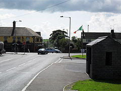
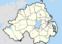
 Cullaville shown within Northern Ireland
Population 400 (2001 Census)
Irish grid reference H910152
    - Belfast 56 mi (90 km)  
District Newry & Mourne
County County Armagh
Country Northern Ireland
Sovereign state United Kingdom
Post town NEWRY
Postcode district BT
Dialling code 028
EU Parliament Northern Ireland
UK Parliament Newry & Armagh
NI Assembly Newry & Armagh
List of places: UK • Northern Ireland • Armagh

Cullaville or Culloville (from Irish: Baile Mhic Cullach, meaning "MacCullach's townland") is a small village and townland near Crossmaglen in County Armagh, Northern Ireland. It is the southernmost settlement in the county and one of the southernmost in Northern Ireland, straddling the Irish border. In the 2001 Census it had a population of 400 people. The village is on a busy crossroads on the main Dundalk to Castleblaney road; three of the roads lead across the border and the fourth leads to Crossmaglen.

The village is home to Culloville Blues GAC. Founded in 1888, and as such, is one of the oldest clubs in Ireland. The club caters for both Gaelic football and Camogie at senior and underage level. The club has two playing fields. The main field is just south of the village, close to the Fane bridge, which marks the border with County Monaghan.

Cullaville's former railway station and post office are south of the River Fane, in County Monaghan.

Contents

History

The Troubles

For more information see The Troubles in Cullaville, which includes a list of incidents in Cullaville during the Troubles resulting in two or more fatalities.

References

See also


Wikimedia Foundation. 2010.

Игры ⚽ Поможем сделать НИР

Look at other dictionaries:

  • The Troubles in Cullaville — recounts incidents during, and the effects of, The Troubles in Cullaville, County Armagh, Northern Ireland.Incidents in Cullaville during the Troubles resulting in two or more fatalities:1973 *24 May 1973 John Wallace (32) and Ian Donald (35),… …   Wikipedia

  • Armagh Senior Leagues — The 2007 Armagh Senior League started on 15th April 2007. It is a Gaelic Athletic Association league. It is split into 4 Divisions (1, 2, 3 and 4).=Results=Weekending 20th May, 2007ACL Division One:Mullabawn 1 8 Pearse Og 2 8IFC: Lissummon 1 8… …   Wikipedia

  • ST Killians GAC — History St. Killian s GAC, Whitecross were formed in 1904 when local parish rivals, Ballymoyer Emmetts and Tullywinney Sarsfields came together to form a team at Whitecross which is the centre of the parish of Loughgilly. They had not long to… …   Wikipedia

  • Whitecross St.Killian's GAA — HistorySt. Killian s GAC, Whitecross were formed in 1904 when local parish rivals, Ballymoyer Emmetts and Tullywinney Sarsfields came together to form a team at Whitecross which is the centre of the parish of Loughgilly. They had not long to wait …   Wikipedia

  • County Armagh — Contae Ard Mhacha Coontie Airmagh / Armagh Coat of arms …   Wikipedia

  • Provisional IRA campaign 1969–1997 — From 1969 until 1997 [Moloney, p. 472] , the Provisional Irish Republican Army (Provisional IRA) conducted an armed paramilitary campaign in the United Kingdom, aimed at ending British sovereignty in Northern Ireland in order to create a united… …   Wikipedia

  • Newry — For other uses, see Newry (disambiguation). Coordinates: 54°10′34″N 6°20′56″W / 54.176°N 6.349°W / 54.176; 6.349 …   Wikipedia

  • Craigavon — Coordinates: 54°26′50″N 6°23′18″W / 54.447222°N 6.388333°W / 54.447222; 6.388333 …   Wikipedia

  • Armagh — For other uses, see Armagh (disambiguation). Coordinates: 54°21′00″N 6°39′17″W / 54.3499°N 6.6546°W / 54.3499; 6.6546 …   Wikipedia

  • Crossmaglen — Coordinates: 54°04′38″N 6°36′32″W / 54.0773°N 6.6088°W / 54.0773; 6.6088 …   Wikipedia

Share the article and excerpts

Direct link
Do a right-click on the link above
and select “Copy Link”