- Yellow Breeches Creek
-
 Fishing in the Boiling Springs Lake tributary to the Yellow Breeches Creek in Boiling Springs
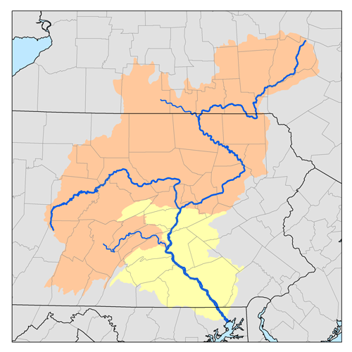
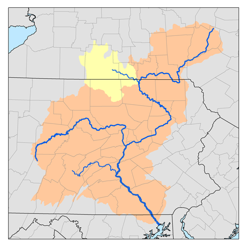
Yellow Breeches Creek,[1] also known as Minnimingo Creek,[citation needed] is a 56.1-mile-long (90.3 km)[2] tributary of the Susquehanna River in central Pennsylvania in the United States.
Yellow Breeches Creek rises on the northwestern side of South Mountain, in the Michaux State Forest, and collects the drainage of several hollows along the mountainside. It flows north through Walnut Bottom and turns east to run down the Cumberland Valley, paralleled by an ex-Reading Railroad line. It passes through Huntsdale, site of the Huntsdale State Fish Hatchery. The creek begins to meander, and swings around the north side of Mount Holly Springs. Just below the town, it is joined by Mountain Creek. Old Town Run enters just before the creek passes along the south side of Boiling Springs and the spring-fed lake that gives the town its name. The Boiling Springs Lake tributary (photo) enters Yellow Breeches Creek east of the town. The tributary's crystal clear water is a popular trout fishing spot.
The creek passes through Williams Grove and meets Dogwood Run just downstream. Below Williams Grove, it forms the boundary between Cumberland and York counties. It flows through the campus of Messiah College, then is joined by Stony Run and enters a series of sharp meanders as the railroad line swings away to the north. Pippins Run joins it, and it flows east to Lisburn, where it makes a sharp turn to flow northwest. It turns north, and then makes a number of meanders to turn east, cutting through the suburbs of New Cumberland. Cedar Run enters near the top of the northernmost meander. It cuts east, then north again, emptying into the Susquehanna.
Known for its great fishing, the Yellow Breeches is a popular spot for fly fishers who flock to the mile-long catch and release section near Boiling Springs. The Yellow Breeches is stocked by the Pennsylvania Fish and Boat Commission as well as local fly shops, including Yellow Breeches Outfitters and Cold Spring Anglers. It is one of the designated Pennsylvania Scenic Rivers.
Contents
Tributaries
- Cedar Run
- Pippins Run
- Stony Run
- Dogwood Run
- Old Town Run
- Mountain Creek
- Boiling Springs Lake Run
See also
References
- ^ U.S. Geological Survey Geographic Names Information System: Yellow Breeches Creek
- ^ U.S. Geological Survey. National Hydrography Dataset high-resolution flowline data. The National Map, accessed August 8, 2011
External links
Susquehanna River system Maryland · Pennsylvania · New York · Counties · Municipalities · Crossings · Dams
Streams shown as: Major tributaries · subtributaries · (subsubtributaries)Lower Susquehanna River  Chesapeake Bay (mouth) · Deer Cr. · Octoraro Cr. · West Br. · East Br. · Broad Cr. · Muddy Cr. · Pequea Cr. · Conestoga R. · Little Conestoga Cr. · Mill Cr. · Cocalico Cr. · (Hammer Cr.) · (Middle Cr.) · Muddy Cr. · Chiques Cr. · Little Chiques Cr. · Codorus Cr. · South Br. · (East Br.) · Conewago Cr. (W) · Little Conewago Cr. · Bermudian Cr. · (South Br.) · Conoy Cr. · Conewago Cr. (E) · Swatara Cr. · Manada Cr. · Quittapahilla Cr. · Little Swatara Cr. · Paxton Cr. · Yellow Breeches Cr. · Mountain Cr. · Conodoguinet Cr. · Middle Spring Cr. · Muddy Run · · Clark Cr. · Sherman Cr. · Juniata R. · Powell Cr. · Wiconisco Cr. · Mahantango Cr. · Pine Cr. · Mahantango Cr (Snyder County). · (North Br.) · (West Br.) · Mahanoy Cr. · Shenandoah Cr. · Penns Cr. · Middle Cr. · Pine Cr. · (Elk Cr.) · Sinking Cr. · Shamokin Cr. · West Br. Susquehanna R.
Juniata River  Susquehanna R. (mouth) · Buffalo Cr. · Cocolamus Cr. · Tuscarora Cr. · East Licking Cr. · Lost Cr. · Jacks Cr. · Kishacoquillas Cr. · Honey Cr. · Aughwick Cr. · Blacklog Cr. · Little Aughwick Cr. · Sideling Hill Cr. · Raystown Br. Juniata R. · Great Trough Cr. · Yellow Cr. · Brush Cr. · Dunning Cr. · (Bobs Cr.) · Standing Stone Cr. · Shaver Cr. · Frankstown Br. Juniata R. · Beaverdam Br. · Clover Cr. · Piney Cr. · Little Juniata R. · Spruce Cr. · Bald Eagle Cr.
West Branch Susquehanna River  Susquehanna R. (mouth) · Chillisquaque Cr. · Buffalo Cr. · White Deer Cr. · White Deer Hole Cr. · Muncy Cr. · Little Muncy Cr. · Loyalsock Cr. · Elk Cr. · Little Loyalsock Cr. · Lycoming Cr. · Larrys Cr. · Antes Cr. · Pine Cr. · Little Pine Cr. · (Texas Cr.) · (Blockhouse Cr.) · Slate Run · Babb Cr. · Marsh Cr. · West Branch Pine Cr. · Bald Eagle Cr. · Fishing Cr. · (Little Fishing Cr.) · Beech Cr. · Marsh Cr. · Spring Cr. · Young Womans Cr. · Kettle Cr. · Cross Fork · Lick Run · Sinnemahoning Cr. · First Fork · Bennett Branch · Driftwood Branch · Mosquito Cr. · Moshannon Cr. · Black Moshannon Cr. · Trout Run · Clearfield Cr. · Little Clearfield Cr. · Beaverdam Run · Anderson Cr. · Chest Cr.
Middle Susquehanna River  West Branch Susquehanna R. · Roaring Cr. · Catawissa Cr. · Fishing Cr. · Little Fishing Cr. · Huntington Cr. · Nescopeck Cr. · Black Cr. · Big Wapwallopen Cr. · Little Wapwallopen Cr. · Harveys Cr. · Lackawanna R. · Spring Brook · Roaring Brook · Bowman Cr. · Tunkhannock Cr. · Martins Cr. · Nine Partners Cr. · Mehoopany Cr. · Meshoppen Cr. · White Cr. · Tuscarora Cr. · Sugar Run Cr. · Wyalusing Cr. · Wysox Cr. · Towanda Cr. · South Br. · Schrader Cr. · Sugar Cr. · Chemung R.
Chemung River  Susquehanna R. (mouth) · Baldwin Cr. · Bentley Cr. · Seeley Cr. · South Cr. · Newtown Cr. · Cohocton R. · Meads Cr. · Mud Cr. · Campbell Cr. · Fivemile Cr. · Tioga R. · Canisteo R. · (Tuscarora Cr.) · (Bennetts Cr.) · (Canacadea Cr.) · Cowanesque R. · (Troups Cr.) · Crooked Cr. · Mill Cr.
Upper Susquehanna River  Chemung R. · Cayuta Cr. · Wappasening Cr. · Pipe Cr. · Owego Cr. · Catatonk Cr. · Apalachin Cr. · Nanticoke Cr. · Choconut Cr. · Chenango R. · Tioughnioga R. · (Otselic R.) · Canasawacta Cr. · Genegantslet Cr. · Sangerfield R. · Snake Cr. · Salt Lick Cr. · Starrucca Cr. · Kelsey Brook · Unadilla R. · Butternut Cr. · Wharton Cr. · Ouleout Cr. · Otego Cr. · Charlotte Cr. · Schenevus Cr. · Cherry Valley Cr. · Oaks Cr. · Otsego Lake (New York) (source)Categories:
- Rivers of Pennsylvania
- Tributaries of the Susquehanna River

Wikimedia Foundation. 2010.