- 1999 Oklahoma tornado outbreak
-
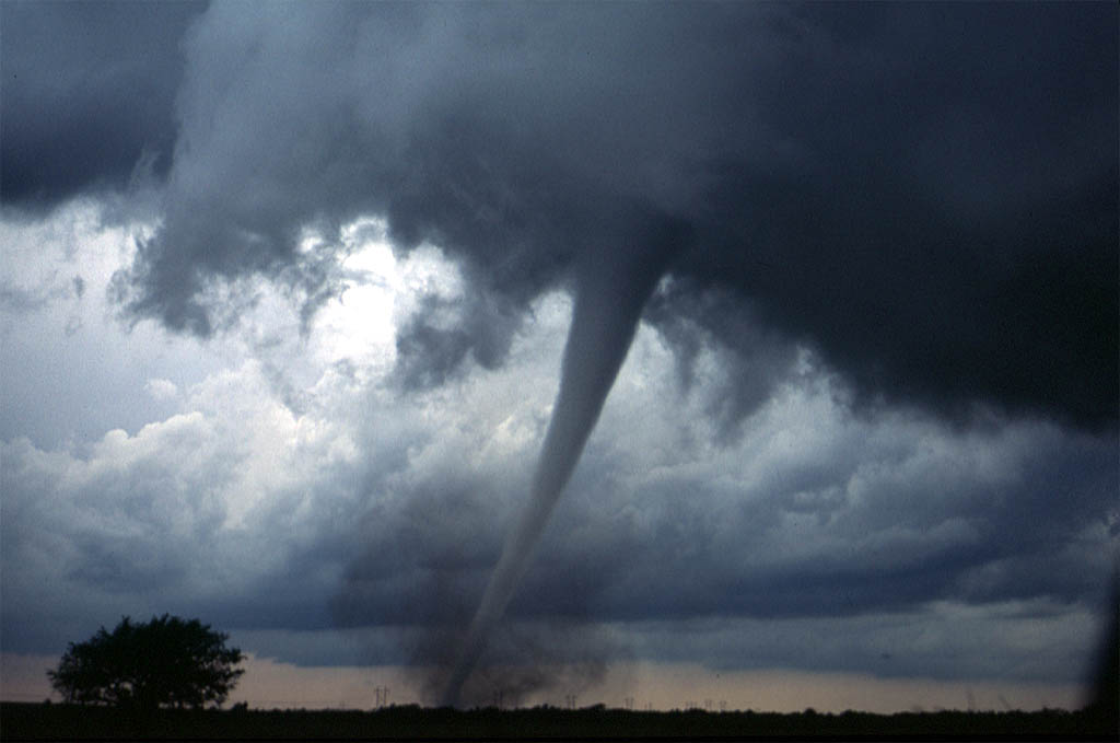
1999 Oklahoma tornado outbreak A tornado near Anadarko, Oklahoma, on May 3, 1999.
Date of tornado outbreak: May 3–6, 1999 Duration1: ~72 hours Maximum rated tornado2: F5 tornado Tornadoes caused: 140 Damages: $1.9 billion (2007 USD) Fatalities: 50 Areas affected: Oklahoma, Kansas, Texas, Tennessee 1Time from first tornado to last tornado
2Most severe tornado damage; see Fujita ScaleThe 1999 Oklahoma tornado outbreak was a severe weather event that lasted from May 3 until May 6, 1999 and brought violent storms to Oklahoma, Kansas, Arkansas, Texas, and Tennessee. This article concentrates on the events on May 3, when 66 tornadoes broke out in Oklahoma and Kansas. The most significant tornado first touched down southwest of Chickasha, Oklahoma, and became an F5 before dissipating over Midwest City, Oklahoma. The tornado tore through Bridge Creek, Oklahoma, Oklahoma City, Moore, Del City, Tinker Air Force Base and Midwest City, Oklahoma, causing $1.1 billion in damage. Forty-eight people perished during the outbreak. This tornadic event ranks in severity with the Palm Sunday tornado outbreak of 1965. With a total of 66-74 tornadoes, it was the most prolific tornado outbreak in Oklahoma history, although not the deadliest.
Contents
Outbreak description
May 3, 1999 started sunny, warm, and humid across the affected region. The Storm Prediction Center in Norman, Oklahoma initially issued a "slight risk" for severe weather for most of the state of Oklahoma early that morning. By late morning the latest observations and forecasts began to indicate an increasing likelihood of widespread severe weather, and the SPC upgraded sections of the southern plains to "moderate risk." By 3 p.m. it had become evident that a widespread severe weather event was imminent. Parts of Oklahoma and Kansas were then further upgraded to "high risk". When a "high risk" is issued, this usually indicates the potential for a significant severe weather event, including damaging tornadoes. The SPC issued a tornado watch by mid-afternoon as conditions gathered together for what would be a historic tornado outbreak. By the afternoon the CAPE values reached nearly 6,000 J/kg over the region. Large supercell thunderstorms developed and in the late afternoon through the mid-evening hours of that Monday, tornadoes began to break out across the state.
Confirmed tornadoes
Main article: List of 1999 Oklahoma tornado outbreak tornadoesConfirmed
TotalConfirmed
F0Confirmed
F1Confirmed
F2Confirmed
F3Confirmed
F4Confirmed
F5140 70 37 18 10 4 1 (based on NOAA Storm Data)
The Bridge Creek-Moore F5
Main article: 1999 Bridge Creek–Moore tornadoPath
The most significant tornado of the outbreak touched down just southwest of the community of Amber, Oklahoma and headed northeast, parallel to Interstate 44, just after another tornado had passed over the airport in Chickasha.[Note 1] The storm continued moving northeast, destroying the community of Bridge Creek and crossing I-44 just north of Newcastle.
The tornado then crossed the Canadian River, passing into far southern Oklahoma City. As it passed over Bridge Creek, around 6:54 p.m., a Doppler On Wheels (DOW: Wurman et al. 1997, Wurman 2001) mobile Doppler weather radar detected winds of 301 mph (484 km/h), ±20 mph inside the tornado at a height of 32 m AGL (Wurman et al. 2007).[1][Note 2] These winds, however, occurred above the ground, and winds at the surface may not have been quite this intense. The tornado continued on into Moore and then passed over the intersection of Shields Boulevard and Interstate 35 and back into Oklahoma City, crossing Interstate 240 near Bryant Avenue. The storm then turned more northerly, striking parts of Del City and Tinker Air Force Base near Sooner Road as an F4 before diminishing over Midwest City and finally lifting near the intersection of Reno Avenue and Woodcrest Drive.
Casualties
 The frame of a pickup truck wrapped around a utility pole from the Moore, Oklahoma F5 tornado
Thirty-six people died in this tornado.[2] Over 8,000 homes were badly damaged or destroyed and the tornado caused $1.1 billion in damage, making it the single most costly tornado in U.S. history, adjusted for inflation.[3] This was also the deadliest tornado since the April 10, 1979 Wichita Falls, Texas Tornado which killed forty- two.[4] However, early warning saved many lives.
Broadcast warnings
Warnings were issued well in advance of the tornado's arrival, and Oklahoma City broadcast media interrupted programming to follow the storms on radar and by helicopter. The death toll would likely have been higher if people had not had advance warning.[5] Following the storm, three of the local television stations in Oklahoma City: KFOR-TV (channel 4), KOCO-TV (channel 5) and KWTV (channel 9) continued coverage of the damaging and deadly tornadoes through May 4. The three stations' chief meteorologists Mike Morgan, Rick Mitchell and Gary England received commendations from then-governor Frank Keating for their coverage of the outbreak.
Most metro area radio stations had simulcast coverage from the area's television stations: KFOR-TV's coverage was simulcast on Renda Broadcasting owned KMGL, KRXO, KOMA-AM and KOMA-FM; KOCO-TV's coverage was simulcast on Clear Channel owned KQSR, KTST and KJYO (KTOK provided their own coverage but utilized KOCO's coverage heavily) with Citadel owned KATT, KYIS, WWLS-AM, WWLS-FM and KKWD simulcasting KOCO's coverage as well; and KWTV's coverage was simulcast on KXXY-FM. It is highly likely that the Emergency Alert System also broadcast warnings.
The Moore tornado also resulted in the National Weather Service issuing the first-ever Tornado Emergency, a severe weather statement used only in extreme cases where a violent tornado is about to impact a densely-populated area.[citation needed]
Impact
Outbreak death toll State Total County County
totalKansas 6 Sedgwick 6 Oklahoma 40 Cleveland 11 Grady 12 Kingfisher 1 Logan 1 McClain 1 Payne 1 Pottawatomie 1 Oklahoma 12 Tennessee 3 Perry 3 Texas 1 Titus 1 Totals 50 All deaths were tornado-related Overpass storm shelter deaths
Three of the deaths reported in the tornado were from people who took shelter underneath overpasses in the area of the path of the Moore-Bridge Creek F5 tornado. The deaths occurred at the 16th Street overpass over Interstate 44 in Newcastle (just east of Bridge Creek), at the Shields Boulevard overpass over Interstate 35 in Moore, and the overpass at mile marker 176.5 on Interstate 35 in rural northwestern Payne County, west of Stillwater.
Fujita scale
This tornado's remarkable wind speed (at the high extreme of the Fujita Scale's F5) led to much speculation that the scale would be modified to include an F6 category, due to the winds possibly exceeding 318 mph (512 km/h). This speculation ignored the fact that the Fujita scale measures damage rather than windspeed, since the scale was developed prior to the introduction of Doppler weather radar. Windspeed estimates associated with the different categories represent the speeds scientists believe are required to produce that damage rather than the windspeed in that particular storm. The damage caused by an F5-designated tornado leaves very little room for a higher category.
The tornado was the last official F5 to hit the United States with the old Fujita scale rating.[6] The next category 5 tornado occurred on May 4, 2007 in Greensburg, Kansas during the May 2007 Tornado Outbreak and killed 11 people. Since February 1, 2007 the National Weather Service has used the Enhanced Fujita Scale to rate tornadoes, and the Greensburg tornado was recorded as the first EF5 tornado. This tornado, however, is not the last category 5 tornado to be rated on the Fujita scale, as Canada still uses the Fujita scale, and a tornado that occurred in Manitoba in June 2007 was rated an F5.
Other significant tornadoes
 Map of the tornadoes that hit near Oklahoma City.
In addition to the devastating F5 tornado that hit the southern suburbs of Oklahoma City, there were numerous other significant tornadoes in the outbreak. An F3 tornado hit the town of Stroud (between Oklahoma City and Tulsa) on Interstate 44, destroying the Tanger Outlet Mall. The mall has not been rebuilt.[7] This tornado also destroyed the local hospital, as well as the Sigma Trucking terminal. While there were no fatalities in Stroud, the economic impact of the tornado has been compared to the loss of Tinker Air Force Base, General Motors, and a major regional hospital for the Stroud region as compared to Oklahoma City at that time. Approximately 800 jobs were lost in a community of approximately 3400. Stroud's recovery was later complicated by the 9/11 attacks, although the town today seems to be in recovery as a result of higher oil and gas prices. Local leading industries include Service King, an oilfield manufacturing facilty, and Mint Turbines, a helicopter engine reconditioning facitility. Stroud is also now a downloading facility for oil produced in the northern United States into the Cushing pipeline network.
An F4 tornado hit the town of Mulhall, north of Guthrie, destroying most of the town and toppling the city's water tower. This wedge tornado was very wide, at times exceeding a width of one mile (1.6 km). According to storm chaser Roger Edwards, it may have been as violent or more than the F5 Moore/Bridge Creek tornado.[8] A Doppler On Wheels (DOW) mobile radar observed this tornado as it crossed Mulhall. The DOW documented the largest ever observed core flow circulation with a distance of 1600 m between peak velocities on either side of the tornado, and a roughly 7 km width of peak wind gusts exceeding 43 m/s, making the Mulhall tornado the largest tornado ever measured quantitatively.[9] The DOW measured a complex multiple vortex structure[10] with several multiple vortices containing winds of up to 115 m/s rotating around the tornado. The 3D structure of the tornado has been analyzed in Lee and Wurman 2005.[11]
One of the final tornadoes in the outbreak nearly hit the studios of ABC affiliate KTUL-TV in Tulsa located on Lookout Mountain, a few miles west of the city, at around 12:15 a.m. CDT on May 4. Chief meteorologist Travis Meyer advised his co-workers to take shelter while he remained on the air reporting on the approaching tornado. It weakened before reaching the station.
The May 3 tornado event was part of a three-day event that included tornadoes in the states of Kansas, Texas and Tennessee. A deadly tornado killed six people in Haysville and Wichita, Kansas, the same day. Other fatalities during the event included one person killed in Texas on May 4, and four people killed in Tennessee on May 5–6.[12]
Damage estimates
 The remains of a disintegrated mobile home in Grady County, Oklahoma from the Moore, Oklahoma F5 tornado
The following is a list of the number of homes and businesses damaged by the tornadoes in the outbreak:[Note 3]
Oklahoma and
Cleveland CountiesOther Counties Homes destroyed 1,780 534 Homes damaged 6,550 878 Businesses destroyed 85 79 Businesses damaged 42 54 Churches destroyed 3 2 Schools destroyed 2 N/A Public buildings destroyed 4 7 Apartments destroyed 473 568 Source: National Weather Service Norman, OK Forecast Office. See also
- List of North American tornadoes and tornado outbreaks
- Climate of Oklahoma City
- Ultimate Tornado (documentary)
- Oklahoma's Advance Tornado Warning Saves Lives (News article)
- Twister (1996 film)
Notes
- Note 1 It may be argued that the tornadoes touching down in Chickasha and Amber were the same storm; however, for weather tracking purposes, each touchdown is counted as a separate tornado which is most probable.
- Note 2 The old record was a 257-268 mph wind measurement from a Doppler weather radar near Red Rock, Oklahoma, as reported in a formal publication by Bluestein et al. (1993)
- Note 3 The following was adapted from public domain, official National Weather Service web sites.
References
- ^ Doppler On Wheels - Center for Severe Weather Research (cswr.org)
- ^ http://www.srh.noaa.gov/oun/?n=events-19990503-storma May 3, 1999 Tornadoes in NWS Norman County Warning Area-Storm A
- ^ However, adjustment for growth in wealth shows the 27 May 1896 Saint Louis–East Saint Louis tornado to be the costliest on record. See Brooks, Harold E.; Doswell III, Charles A. (2001). "Normalized Damage from Major Tornadoes in the United States: 1890–1999". Weather and Forecasting 16 (1): 168–176. Bibcode 2001WtFor..16..168B. doi:10.1175/1520-0434(2001)016<0168:NDFMTI>2.0.CO;2. ISSN 1520-0434.
- ^ Brooks, Harold E.; Doswell III, Charles A. (2002). "Deaths in the 3 May 1999 Oklahoma City Tornado from a Historical Perspective". Weather and Forecasting 17 (3): 354–361. Bibcode 2002WtFor..17..354B. doi:10.1175/1520-0434(2002)017<0354:DITMOC>2.0.CO;2. ISSN 1520-0434.
- ^ Quoetone, Elizabeth M; David L Andra, William F Bunting (2007-06-14). "Warning Decision Making Process During the 3 May 1999 Tornado Outbreak". Warning Decision Training Branch, National Oceanic and Atmospheric Administration. http://www.wdtb.noaa.gov/modules/sls00/otboun.pdf.
- ^ "F5 and EF5 Tornadoes of the United States". www.spc.noaa.gov. http://www.spc.noaa.gov/faq/tornado/f5torns.html. Retrieved 25 January 2011.
- ^ Tanger Factory Outlet Centers, Inc. -- Company History
- ^ Central Oklahoma Tornado Intercept: 3 May 1999 (Roger Edwards)
- ^ Wurman, Joshua; C. Alexander, P. Robinson, and Y. Richardson (January 2007). "Low-Level Winds in Tornadoes and Potential Catastrophic Tornado Impacts in Urban Areas". Bulletin of the American Meteorological Society (American Meteorological Society) 88 (1): 31–46. Bibcode 2007BAMS...88...31W. doi:10.1175/BAMS-88-1-31. http://ams.allenpress.com/perlserv/?request=get-abstract&doi=10.1175%2FBAMS-88-1-31.
- ^ Wurman, Joshua (June 2002). "The Multiple-Vortex Structure of a Tornado". Weather and Forecasting (American Meteorological Society) 17 (3): 473–505. Bibcode 2002WtFor..17..473W. doi:10.1175/1520-0434(2002)017<0473:TMVSOA>2.0.CO;2. ISSN 1520-0434. http://ams.allenpress.com/perlserv/?request=get-abstract&doi=10.1175%2F1520-0434(2002)017%3C0473:TMVSOA%3E2.0.CO%3B2.
- ^ Lee, Wen-Chau; J. Wurman (July 2005). "Diagnosed Three-Dimensional Axisymmetric Structure of the Mulhall Tornado on 3 May 1999". Journal of the Atmospheric Sciences (American Meteorological Society) 62 (7): 2373–93. Bibcode 2005JAtS...62.2373L. doi:10.1175/JAS3489.1.
- ^ http://www.srh.noaa.gov/ohx/?n=stormsurvey05051999
External links
- May 3, 1999 Oklahoma Tornado Special Report - The Oklahoman
- Great Plains Outbreak of 1999 Tornado History Project
- The Great Plains Tornado Outbreak of May 3, 1999 (National Weather Service, Norman, Oklahoma)
- The 3 May 1999 Oklahoma Tornadoes (David Schultz, CIMMS)
- Google Maps' location of Stroud, Oklahoma, with the bulldozed lot of the former Tanger Outlet Mall in the upper left of the screen, just north of Interstate 44
- May 3 Oklahoma Tornado Special video section from KOCO-TV
- Moore, Oklahoma Tornado Photos, May 1999 Aerial Photos of Moore Oklahoma taken three days after the May 3, 1999 tornado
10 costliest US tornadoes Rank Area affected Date Damage 1 Adjusted Damage 2 1 Joplin, Missouri May 22, 2011 2800 2800 2 Tuscaloosa, Alabama April 27, 2011 2200 2200 3 Oklahoma City Metro, Oklahoma May 3, 1999 1000 1318 4 Hackleburg, Alabama April 27, 2011 1250 1250 5 Wichita Falls, Texas April 10, 1979 400 1209 6 Omaha, Nebraska May 6, 1975 250 1019 7 Lubbock, Texas Tornado May 11, 1970 135 763 8 Topeka, Kansas Tornado June 8, 1966 100 676 9 Windsor Locks, Connecticut October 3, 1979 200 605 10 St. Louis-East St. Louis Tornado May 27, 1896 12 520
Source: Brooks, Harold E.; C.A. Doswell (Feb 2001). "Normalized Damage from Major Tornadoes in the United States: 1890–1999". Weather and Forecasting (American Meteorological Society) 16 (1): 168-76. doi:10.1175/1520-0434(2001)016<0168:NDFMTI>2.0.CO;2. http://ams.allenpress.com/perlserv/?request=get-abstract&doi=10.1175%2F1520-0434(2001)016%3C0168%3ANDFMTI%3E2.0.CO%3B2. 3
1. These are the unadjusted damage totals in millions of US dollars.
2. Raw damage totals adjusted for inflation, in millions of 2011 USD.
3. A search of NCDC Storm Data indicates no tornadoes between 1999 and 2010 have caused more than $250 million in damage.Categories:- F5 tornadoes
- Tornadoes of 1999
- Tornadoes in Kansas
- Tornadoes in Oklahoma
- 1999 in the United States
- Natural disasters in Oklahoma


Wikimedia Foundation. 2010.