- Colerne
-
Coordinates: 51°26′20″N 2°15′43″W / 51.439°N 2.262°W
Colerne 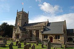
St. John the Baptist parish church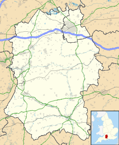
 Colerne
Colerne shown within WiltshirePopulation 2,807 (2001 census) OS grid reference ST8271 Parish Colerne Unitary authority Wiltshire Ceremonial county Wiltshire Region South West Country England Sovereign state United Kingdom Police Wiltshire Fire Wiltshire Ambulance Great Western EU Parliament South West England List of places: UK • England • Wiltshire Colerne is a village and civil parish in the Cotswolds Area of Outstanding Natural Beauty, midway between Bath and Chippenham in Wiltshire, England. It has an elevated position 545 feet (166 m) above sea level and overlooks the Box Valley to the south (where Isambard Kingdom Brunel's Box Tunnel is). It is bounded by a stretch of the Fosse Way Roman road to the west and by Bybrook to the south-east.
The 2001 census recorded a parish population of 2,807 in 2001.[1] Colerne is frequently described as "The Village on the Hill".
Contents
Toponym
The name Colerne appears in the Domesday Book (1086). Other early spellings include Culerna, Culerne, Cullerne, Collern.[2] Various interpretations of the name have been proposed.
Gover, Mawer and Stenton, in The Place Names of Wiltshire (1939), cite a form aern meaning 'house', and say "col-aern might well denote a house where charcoal was made, used or stored." The altitude of the village suggests that the first syllable is from the Welsh or Cornish word col, 'peak' (John C. Langstaff, Notes on Wiltshire Names, 1911). This would mean the 'dwelling on the peak'. Alternatively it could mean 'cold dwelling' from the Anglo-Saxon cald.
Yet another likely derivation is from (Goidelic)= Old Irish, 'Cuillean', (Brythonnic)= Welsh, Celyn or Celynnen, and (Old English) Holegn(the 'h' is pronounced gutturally). Each of these words translate to 'holly' tree or holly branches which were significant in Celtic history and folk-lore. Colerne was in existence and farmed many years B.C., pre-dating the Normans and Anglo-Saxons. There is the remains of an Iron-Age Hillfort at Colerne (Bury Camp).
Local government
Colerne civil parish is administered by a parish council and by the Wiltshire Council unitary authority.
Trivia
- The clock on the church tower has only one hand. There is a similar one-handed clock on Westminster Abbey.
- Bristol Rovers training facilities are based in Colerne.
- The former RAF Colerne, located nearby, was one of very few airfields suitable for the rare Westland Whirlwind during World War II, operated by No. 263 Squadron RAF.
- The former RAF Colerne, hosted 616 squadron, the first Allied squadron with jets, relocating with Gloster Meteor I's from Culmhead and then re-equipping with Meteor III's.
Notable residents
- Derek Fowlds (b. 1937), the British actor (Yes Minister; formerly straight man to Basil Brush) was a former resident of the village.
- Brian Ashton (b. 1946), rugby union player and England coach from late 2006 to April 2008, is a resident of the village.
- Geof Willis (b. 1954), the author of the The Epehy Affair, was born in Martins Croft.
- Identity Crisis, post-punk pioneers, had a studio in a Colerne farm in the 1980s.
- Goldfrapp (b. 1966 & b. ?), the electronic music duo, are former residents of the village.
- Kristan Bromley (b. 1972) and Shelley Rudman (b. 1981), champion skeleton racers, are currently resident in Colerne.
The Colerne Donkey
According to village legend, a Colerne parson in former years owned a donkey to which he was much attached. While the clergyman was away, the unfortunate ass died, and the sexton felt it proper to have the beast buried in consecrated ground. But the undertaker, inexperienced in interring specimens of E. asinus, neglected to dig the grave wide and deep enough, so the donkey was buried feet-up with its hooves sticking out. The parson had the animal reburied when he returned, but the story was already out, and well into the 20th century young men from the nearby villages of Box or Marshfield who were at a loose end needed only visit Colerne and mention the word Donkey sufficiently loudly in order to be rewarded with a violent altercation on a moment's notice. It was also the habit for visiting footballers unacquainted with Colerne history to be dispatched to the home dressing room with a piece of sandpaper and instructions to ask to polish the donkey's hooves. This usually resulted in the erstwhile innocent becoming sadder and wiser in short order.
References
- ^ Wiltshire Community History Colerne Census Information. Retrieved on October 10, 2006.
- ^ Ekwall, Concise Oxford Dictionary of English Place-names
External links
- Colerne Parish Council
- Ecolerne – sustainable village group
- Wiltshire Planning: Details of Planning Application - 09/01844/S73A - Breach Wood, Colerne
- The Cotswolds Area of Outstanding Natural Beauty
Categories:- Villages in Wiltshire
- Civil parishes in Wiltshire


Wikimedia Foundation. 2010.