- Montauk Point Light
-
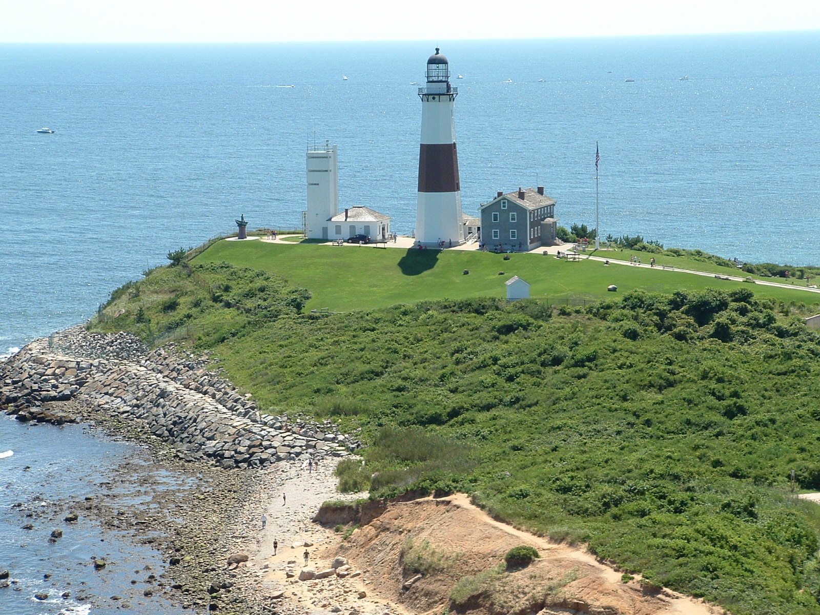
Montauk Point Light 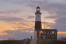
Montauk Point Lighthouse Location Montauk Point, Suffolk County, New York Year first lit 1797 Automated 1987 Foundation 13 ft (4 m) deep and 9 ft (3 m) thick, Natural, Emplaced, built in 1796 Construction Sandstone Tower shape Octagonal pyramidal Markings / pattern Tower painted white with a broad brown band midway, lantern black Height 110.5 ft (33.7 m) structure Focal height 168 ft (51 m) Original lens 8 whale oil lamps (1797), Fresnel lens Current lens VRB-25 Range 18 nm Characteristic Flashing White 5 seconds. Fog signal Horn: 1 2s in every 15s ARLHS number USA-512 USCG number 1-660 Montauk Point Lighthouse

Nearest city: East Hampton, New York Coordinates: 41°4′15.480″N 71°51′25.528″W / 41.0709667°N 71.85709111°WCoordinates: 41°4′15.480″N 71°51′25.528″W / 41.0709667°N 71.85709111°W Area: 0 acres (0 ha) Built: 1796 Architect: McComb,Jr.,John Governing body: U.S. Coast Guard NRHP Reference#: 69000142
[3]Added to NRHP: July 07, 1969 The Montauk Point Light is a lighthouse located in Montauk Point State Park at the easternmost point of Long Island, in the Town of East Hampton, Suffolk County, New York. The lighthouse was the first to be built within the state of New York, and is currently the fourth oldest active lighthouse in the United States.[4]
Contents
History
 A stylized image of the Montauk Point Light graces the shields of each of Long Island's state parkways.
Construction on the lighthouse was authorized by the Second United States Congress, under President George Washington on April 12, 1792. Construction began on June 7, 1796, and was completed on November 5, 1796, the first public works project of the United States of America. Sometime in early April of 1797 keeper Jacob Hand lit the wicks in the lamps in the tower and the lighthouse began operation. The lighthouse was operated by civilian keepers until World War II.[5]
During World War II, the lighthouse was taken over by the U.S. Army as part of the Eastern Coastal Defense Shield. The last three civilian keepers, Thomas Buckridge, Jack Miller, and George Warrington departed in the spring of 1943. Adjacent to the lighthouse, Camp Hero was opened by the Army in 1942 and was heavily fortified with huge guns during the war. Those gun emplacements and concrete observation bunkers (which are also at nearby Shadmoor State Park) are still visible. In 1946 the United States Coast Guard took over maintenance of the lighthouse and operated it until the station was automated on February 3, 1987.
It was the first lighthouse in New York State, and is the fourth-oldest active lighthouse in the United States. The tower is 110' 6" high. The current light, installed in July 2001, equivalent to approximately 290,000 candle power, flashes every 5 seconds and can be seen a distance of 17 nautical miles (31 km).[4]
Pirate Captain Kidd was said to have buried treasure at the foot of the lighthouse around 1699 at two ponds which today are called "Money Ponds."[6]
In 1860 the lighthouse station underwent a massive renovation when two new levels and a larger lantern were added to the lighthouse, increasing the height of the tower from its original 80 feet (1796) to its current height of 110' 6". A first order Fresnel lens, 12 foot high, 6 feet in diameter, and weighing about 10,000 pounds was installed in the new lantern. At the same time, the current keeper's dwelling was constructed adjacent to the tower. The original 1796 dwelling was then demolished.
A steam-powered fog signal was installed in 1873. A fog signal building was added in 1897.
The tower was originally all white. Its single brown stripe was added in 1899. A fourth order fixed red range light was added to the watchdeck of the tower in 1903 to warn of Shagwong Reef, a navigational hazard about 3 1/2 miles northwest of the lighthouse. It was severely damaged in the hurricane of September 21, 1938 and removed on July 1, 1940 when the lighthouse was electrified.
The huge first order Fresnel lens was replaced in 1903 with a 3 1/2 order bivalve Fresnel lens, which served until February 3, 1987 when it was replaced with an airport beacon with a strength of 2.5 million candela.
The Coast Guard considered tearing down the lighthouse in 1967 and replacing it with a steel tower further from the edge of the bluff. When the tower was built on Turtle Hill it was 300 feet (90 m) from the edge of the cliff. It is now 100 feet (30 m) away from the edge. After World War II the United States Army Corps of Engineers built a seawall at its base, but the erosion continued. In the wake of protests over the announced dismantling of the tower, Congressman Michael Forbes proposed a bill to the United States Congress to hand over the Lighthouse to the Montauk Historical Society from the Public so it could preserved.[7] The bill was passed. Then, Giorgina Reid (1908–2001), a textile designer who had saved her Rocky Point, New York cottage from collapse by building a simple set of terraces in the gullies of the bluff, proposed to the Society to do the same at Montauk. It is now 100 feet (30 m) away from the edge. Reid's concept Reed-Trench Terracing called for building the terrace platforms made of various beach debris—notably reeds. The practice (along with further strengthening of the rocks at the bluff toe) has appeared to have stemmed the erosion. She patented the process and wrote an article about it titled How to Hold up a Bank[8].
Greg Donohue, a Montauk landscaper, worked with Giorgina Reid at the Point and kept the project moving forward after she retired in 1986. With support from various sources, including the Montauk Historical Society, the State of New York, and other agencies, the Erosion Control Project of Montauk Point was successfully completed in 1998. Problems in recent years have again prompted attention to forestall the erosion threat.
It was reported in November 2006 that the United States Army Corps of Engineers was planning to build a seawall to solve the continuing erosion problem. This plan has been opposed by a local surfing group which contends that a seawall would ruin the nearby world-renowned surf break, and propose moving the lighthouse back from the shore, as was done with the Cape Hatteras Lighthouse.[9] Complicating such a move is the terrain that would require the lighthouse to be moved down one hill and then up another hill. There are also environmental concerns about whether reducing the erosion at Montauk would increase erosion at other Long Island beaches.[10] It remains to be seen whether the seawall plans will be affected by these concerns.
The lighthouse was automated on February 3, 1987, and in May of that year the lighthouse museum opened to the public, operated by the Montauk Historical Society, who leased the property from the US Coast Guard for that purpose. On September 30, 1996 President Bill Clinton signed legislation transferring the lighthouse property over to the Montauk Historical Society.
Suffolk Transit's S94 route also serves the lighthouse seasonally connecting it with Montauk Village.
References
- ^ (PDF) Light List, Volume I, Atlantic Coast, St. Croix River, Maine to Shrewsbury River, New Jersey. Light List. United States Coast Guard. 2009. p. 8. http://www.navcen.uscg.gov/pdf/lightLists/LightList%20V1.pdf.
- ^ "Historic Light Station Information and Photography: New York". United States Coast Guard Historian's Office. http://www.uscg.mil/history/weblighthouses/LHNY.asp.
- ^ "National Register Information System". National Register of Historic Places. National Park Service. 2009-03-13. http://nrhp.focus.nps.gov/natreg/docs/All_Data.html.
- ^ a b "Lighthouse Facts". Montauk Light House.com. http://www.montauklighthouse.com/facts.htm. Retrieved 2008-06-24.
- ^ William G. Tyrrell (May 1969). "National Register of Historic Places Registration: Montauk Point Lighthouse". New York State Office of Parks, Recreation and Historic Preservation. http://www.oprhp.state.ny.us/hpimaging/hp_view.asp?GroupView=8834. Retrieved 2010-02-20. See also: "Accompanying photo". http://www.oprhp.state.ny.us/hpimaging/hp_view.asp?GroupView=8871.
- ^ Pirates and Prohibition - Excerpted From "East Hampton History," by Jeannette Edwards Rattroy - 1953 (republished on longislandgeneology.com - Retrieved 2007-01-12)
- ^ [1]
- ^ "Against All Odds" on Official Montauk Lighthouse website
- ^ Kilgannon, Corey (November 14, 2006). "For Montauk, It’s Lighthouse vs. Surf’s Up!". The New York Times. http://www.nytimes.com/2006/11/14/nyregion/14light.html. Retrieved 2009-09-02.
- ^ Dean, Cornelia (November 21, 2006). "The Coastline Is Retreating. Should the Montauk Lighthouse Stand Its Ground?". The New York Times. http://www.nytimes.com/2006/11/21/science/earth/21comm.html. Retrieved 2009-09-02.
External links
- The Official Montauk Point Lighthouse Web Site
- National Park Service List of New York Lighthouses
- New York State Parks: Montauk Point State Park
Image gallery


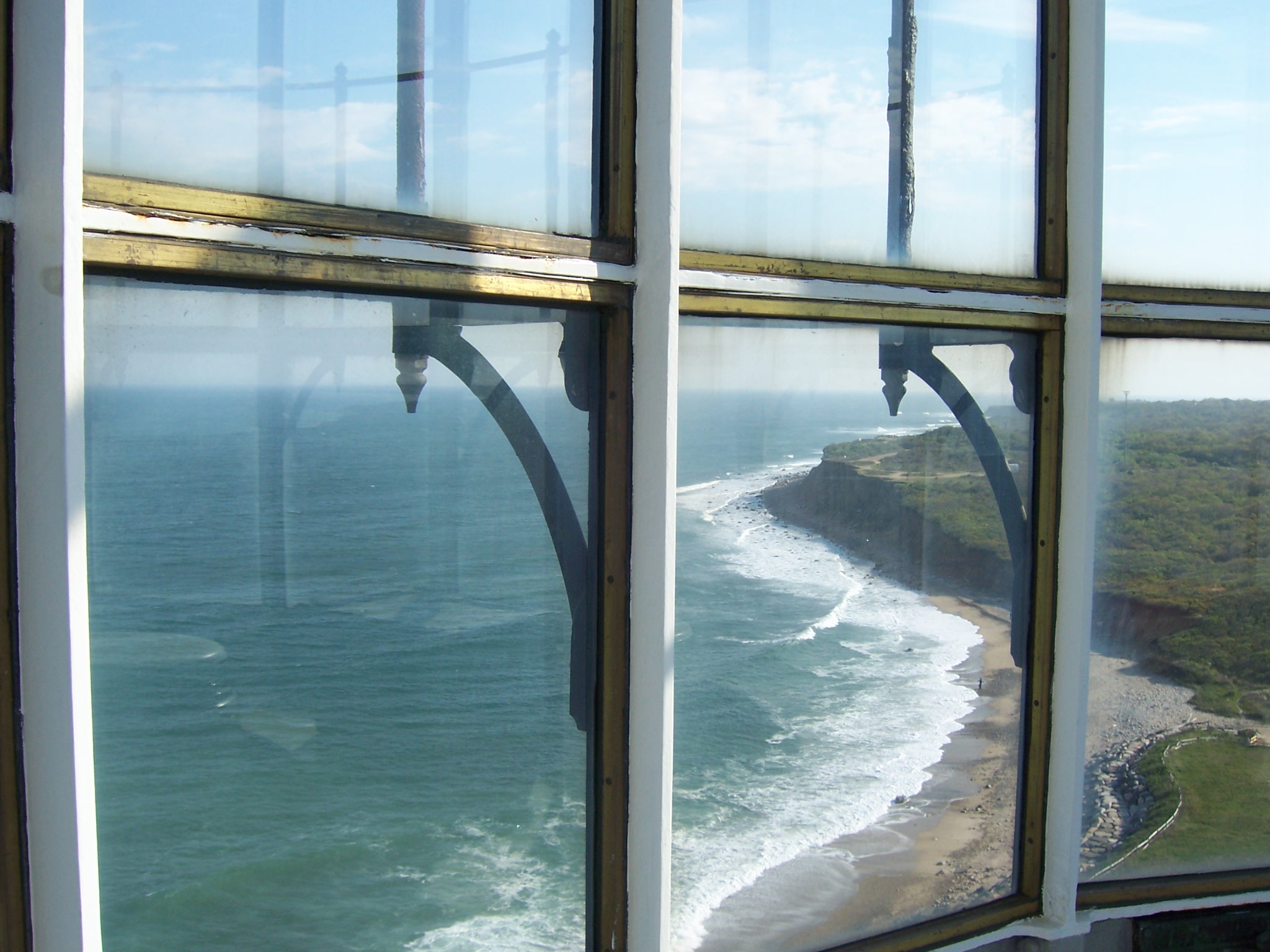
 Looking out from the top of the lighthouse.


Further reading
- "On Eagle's Beak: A History of the Montauk Point Lighthouse" by Henry Osmers. Outskirts Press, 2008.
- "Living on the Edge: Life at the Montauk Point Lighthouse 1930-1945" by Henry Osmers. Outskirts Press, 2009.
- "They Were All Strangers: the Wreck of the John Milton at Montauk, New York" by Henry Osmers. Outskirts Press, 2010.
Lighthouses of New York Ambrose Tower Light · Aunt Phebe Rock Light · Barber's Point Light · Barcelona (Portland Harbor) Light · Blackwell Island Light · Bluff Point Light · Braddock Point Light · Buffalo Light · Buffalo Harbor North and South entrance Lights · Buffalo Harbor South Entrance Light · Buffalo North breakwater East end Light · Buffalo North Breakwater South End Light · Cape Vincent Light · Carleton Island Light · Cedar Island Light · Cold Spring Harbor Light · Coney Island Light · Coxsackie Light · Crossover Island Light · Crown Point Light · Cumberland Head Light · Dunkirk Light · East Charity Shoal Light · Eatons Neck · Elm Tree Beacon Light · Esopus Meadows Light · Execution Rocks Light · Fair Haven Light · Fire Island Light · Fort Niagara Light · Fort Lafayette Light · Fort Tompkins Light · Fort Wadsworth Light · Galloo Island Light · Gardiners Point Island · Horse Island Light · Horton Point Light · Hudson-Athens Light · Huntington Harbor (Lloyd Harbor) Light · Kings Point Light · Latimer Reef Light · Little Gull Island Light · Little Red Lighthouse (Jeffrey's Hook) · Montauk Point Light · Moriches Light · New Dorp Light · North Brother Island Light · North Dumpling Light · Oak Orchard Light · Old Field Point Light · Old Orchard Shoal Light · Ogdensburg Harbor Light · Orient Long Beach Bar Light · Orient Point Light · Oswego Harbor West Pierhead Light · Plattsburgh Beacon Light · Plum Island Light · Point Aux Roches Light · Princes Bay Light · Race Rock Light · Rock Island Light · Romer Shoal Light · Rondout Light · Sands Point Light · Saugerties Light · Selkirk Light · Shinnecock Light · Sodus Outer Light · Sodus Point Light · South Brother Island Channel Range Light · South Buffalo North Side Light · Split Rock Point Light · Staten Island Light · Statue of Liberty · Stepping Stones Light · Stony Point (Henderson) Light · Stony Point Light · Strawberry Island Upper Cut Range Light · Stuyvesant Light · Sunken Meadows Light · Sunken Rock Light · Tarrytown (Sleepy Hollow) Light · Thirty Mile Point Light · (Three) Sisters Island Light · Throgs Neck Light · Tibbetts Point Light · Turkey Point (NY) Light · Watervliet Light · West Point Light · West Bank Light · Whitehall Narrows Light · Whitestone Point Light Categories:
- East Hampton (town), New York
- Lighthouses on the National Register of Historic Places in New York
- Museums in Suffolk County, New York
- Lighthouse museums in New York
- Visitor attractions on Long Island


Wikimedia Foundation. 2010.