- New York State Route 270
-
NYS Route 270
Campbell Boulevard 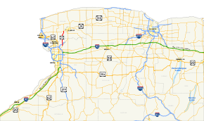
Map of western New York with NY 270 highlighted in redRoute information Maintained by NYSDOT Length: 9.52 mi[2] (15.32 km) Existed: 1930[1] – present Major junctions South end:  NY 263 in Amherst
North end: 
 NY 31 / NY 93 in Pendleton
Location Counties: Erie, Niagara Highway system Numbered highways in New York
Interstate • U.S. • N.Y. (former) • Reference • County←  NY 269
NY 271  →
→New York State Route 270 (NY 270) is a north–south state highway in western New York in the United States. It runs through rural and wooded areas of the town of Amherst in Erie County and the town of Pendleton in Niagara County. The southern terminus of the route is at an intersection with NY 263 south of the hamlet of Getzville. Its northern terminus is at a junction with NY 31 and NY 93 west of the city of Lockport. The entirety of NY 270 is known as Campbell Boulevard.
NY 270 was assigned as part of the 1930 renumbering of state highways in New York. The route once extended as far south as NY 5 and as far north as NY 104; however, it was gradually truncated to its current length as other routes were realigned or extended onto NY 270's alignment.
Contents
Route description
Route 270's southern terminus is just north of SUNY Buffalo's north campus, at an intersection with Millersport Highway (NY 263) with some office parks and gas stations that marks the center of Getzville, a hamlet within the town of Amherst. It runs due north, underneath Interstate 990 without an exit, into the still-wooded areas of what is known as North Amherst, and then crosses the Tonawanda Creek and the county line.
In Niagara County it runs past typically deforested fields and some houses, again continuing mostly straight due north, to an intersection with NY 31 and NY 93.
Timothy McVeigh, the executed Oklahoma City bomber, grew up in a house along Campbell Boulevard in the town of Pendleton.[citation needed]
History
Designation
When NY 270 was assigned as part of the 1930 renumbering of state highways in New York, it began at Main Street (NY 5) in the hamlet of Eggertsville and followed Eggert Road north to Millersport Highway. Here, it turned to the northeast, utilizing what is now NY 263 to the modern campus of SUNY Buffalo. While today's Millersport Highway veers east to bypass the college, the highway originally went straight through the grounds, partially by way of what is now St. Rita's Lane. North of Ellicott Creek, NY 270 proceeded to Getzville via North Forest and Stahl Roads. At Getzville, NY 270 joined its modern alignment and followed it to Saunders Settlement Road (now NY 31), where it turned northeast onto Saunders Settlement Road for a short distance to Upper Mountain Road, where it ended at NY 3 outside of Lockport.[1]
Both extents of NY 270 were realigned slightly by 1932. In the vicinity of Eggertsville, the route was reconfigured to follow Bailey Avenue and Grover Cleveland Highway between Main Street and Eggert Road. Near Lockport, NY 270 was shifted southward onto Hinman Road and Ohio Street. The latter change was made as part of a larger realignment of NY 3 through central Niagara County.[3] The realignment of NY 270 near Lockport was short-lived as the route was moved back onto Campbell Boulevard ca. 1935; however, it was also truncated to end at the junction of Campbell Boulevard and Saunders Settlement Road.[4][5] NY 270 was truncated again in the mid-1930s after U.S. Route 62 (US 62) and NY 18 were realigned to follow Bailey Avenue between Main Street and Sheridan Drive (NY 324).[6][7]
Truncations
By 1935, NY 270 was realigned to bypass North Forest and Stahl Roads by way of a new section of Millersport Highway.[5] In the early 1940s, NY 270 was extended north over Junction Road to meet US 104 at Warrens Corners. Around the same time, NY 263 was extended southwest to Buffalo over NY 270.[8][9] Initially, NY 263 overlapped with NY 270 along Millersport Highway; however, the overlap was eliminated in the late 1940s after NY 270 was truncated to begin at NY 263 in Getzville.[10][11] Similarly, NY 270 initially overlapped with NY 93 along Junction Road from Lower Mountain Road to US 104. At Lower Mountain Road, NY 93 left NY 270 and proceeded east toward Lockport on Lower Mountain and Gothic Hill Roads.[8][9] NY 270 was truncated to the southern end of the overlap ca. 1963.[12][13]
In the late 1970s, NY 93 was realigned to use Junction and Upper Mountain Roads instead. As a result, NY 270 was cut back to its junction with Upper Mountain Road.[14][15] On November 1, 2005, the Niagara County Legislature voted on a measure that, if passed, would allow the county to ask the New York State Department of Transportation (NYSDOT) to remove the NY 93 designation from Upper Mountain Road, a county-maintained highway, and reassign it to Junction Road (NY 270) and Saunders Settlement Road (NY 31).[16][17] The change was intended to eliminate truck traffic on Upper Mountain Road while providing additional capacity to NY 93.[citation needed] This part of the agenda was passed. NYSDOT obliged to the request soon afterward, rerouting NY 93 as proposed and truncating NY 270 southward to NY 31.[18]
Other developments
On December 1, 2008, the bridge carrying NY 270 over Tonawanda Creek (also the Erie Canal) was closed to traffic to allow construction to begin on a replacement bridge over the creek.[19] The existing bridge was built in 1941 and considered to be structurally deficient.[20] During construction, commuter traffic was detoured onto Tonawanda Creek and Bear Ridge Roads while trucks were instructed to follow NY 263, NY 78, and NY 93 around the closed bridge. The new bridge was opened to traffic in July 2009.[19] NY 270's intersections with Tonawanda Creek Road (Erie CR 2) and Tonawanda Creek Road North (Niagara CR 60) on the north and south approaches to the bridge were reconstructed as part of the $10.9 million project. The new bridge is similar to the former, two-lane structure; however, unlike the old one, it has wide shoulders for bicyclists and includes new sidewalks for pedestrians.[21]
Major intersections
County Location Mile[2] Destinations Notes Erie Amherst 0.00 NY 263 (Millersport Highway)Hamlet of Getzville 0.56  CR 45 (Dodge Road)
Former eastern terminus of NY 356 1.29  CR 299 (North French Road) to I-990
Niagara Pendleton 9.52 NY 31 / NY 931.000 mi = 1.609 km; 1.000 km = 0.621 mi References
- ^ a b Standard Oil Company of New York (1930). Road Map of New York (Map). Cartography by General Drafting.
- ^ a b "2008 Traffic Volume Report for New York State" (PDF). New York State Department of Transportation. June 16, 2009. p. 202. https://www.nysdot.gov/divisions/engineering/technical-services/hds-respository/NYSDOT%20TVR%202008%20by%20Route.pdf. Retrieved January 30, 2010.
- ^ Texas Oil Company (1932). Texaco Road Map – New York (Map). Cartography by Rand McNally and Company.
- ^ Texas Oil Company (1934). Texaco Road Map – New York (Map). Cartography by Rand McNally and Company.
- ^ a b Sun Oil Company (1935). Road Map & Historical Guide – New York (Map). Cartography by Rand McNally and Company.
- ^ Shell Oil Company (1935). Niagara Falls and Vicinity (Map). Cartography by H.M. Gousha Company. http://www.ontarioroadmaps.ca/Oil_Companies/Shell/1935/Niagara.jpg. Retrieved May 27, 2010.
- ^ Thibodeau, William A. (1938). The ALA Green Book (1938–39 ed.). Automobile Legal Association.
- ^ a b Esso (1940). New York (Map). Cartography by General Drafting.
- ^ a b Esso (1942). New York with Pictorial Guide (Map). Cartography by General Drafting.
- ^ Sinclair Oil Corporation (1947). New York Road Map and Pictorial Sight-Seeing Guide (Map). Cartography by Rand McNally and Company.
- ^ Socony-Vacuum Oil Company (1950). New York (Map). Cartography by Rand McNally and Company.
- ^ Esso (1962). New York with Sight-Seeing Guide (Map). Cartography by General Drafting (1962 ed.).
- ^ Esso (1963). New York Happy Motoring Guide (Map). Cartography by General Drafting (1963 ed.).
- ^ Exxon (1977). New York (Map). Cartography by General Drafting (1977–78 ed.).
- ^ State of New York (1981). I Love New York Tourism Map (Map). Cartography by Rand McNally and Company.
- ^ Prohaska, Thomas J. (October 31, 2005). "Shift in Route 93 designation sought". The Buffalo News.
- ^ Niagara County, New York (November 1, 2005). "Niagara County Legislature Agenda". http://www.niagaracounty.com/legislature_agenda_110105.asp. Retrieved January 19, 2010.
- ^ New York State Department of Transportation (October 2007). Official Description of Highway Touring Routes, Bicycling Touring Routes, Scenic Byways, & Commemorative/Memorial Designations in New York State.
- ^ a b "NY Route 270 (Campbell Boulevard) Bridge over Erie Canal and Tonawanda Creek in Towns of Amherst and Pendleton Closed on December 1, 2008" (Press release). New York State Department of Transportation. November 26, 2008. https://www.nysdot.gov/news/traveler-advisories/2006/2008-11-261. Retrieved May 28, 2010.
- ^ Federal Highway Administration (2009). "Structure 4044050". National Bridge Inventory. United States Department of Transportation. http://nationalbridges.com/nbi_record.php?StateCode=36&struct=000000004044050. Retrieved May 28, 2010.
- ^ "Campbell Boulevard over the Erie Canal". New York State Department of Transportation. https://www.nysdot.gov/regional-offices/region5/projects/campbell-blvd-over-eriecanal. Retrieved May 28, 2010.
External links
Categories:- State highways in New York
- Transportation in Erie County, New York
- Transportation in Niagara County, New York


Wikimedia Foundation. 2010.