- Chislet
-
Coordinates: 51°20′11″N 1°11′28″E / 51.336330°N 1.191000°E
Chislet 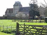
St Mary the Virgin Church, Chislet village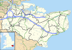
 Chislet
Chislet shown within KentOS grid reference TR223642 District City of Canterbury Shire county Kent Region South East Country England Sovereign state United Kingdom Police Kent Fire Kent Ambulance South East Coast EU Parliament South East England List of places: UK • England • Kent Chislet is a sprawling rural parish in the northeast of the English county of Kent between the city of Canterbury and the Isle of Thanet. It is also the name of a village within the parish.
Until its closure in 1970, Chislet colliery was the most northerly in Kent. Chislet had a windmill until 2005, when it was burnt down. The mill stood 2¼ miles (3.6 km) from the church.
Chislet parish includes the villages:
- Boyden Gate
- Chislet
- Chislet Forstal
- Highstead
- Marshside
- Upstreet
External links
Towns and villages in the Canterbury district of Kent, England 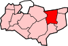 Adisham • Barham • Bekesbourne • Beltinge • Bishopsbourne • Blean • Boyden Gate • Bramling • Bridge • Broad Oak • Broomfield • Chartham • Chartham Hatch • Chestfield • Chislet • Eddington • Fordwich • Grays • Hackington • Harbledown • Hawthorn • Herne • Herne Bay • Hersden • Hillborough • Hoath • Ickham • Kingston • Littlebourne • Lower Hardres • Marshside • Nackington • Patrixbourne • Petham • Pett Bottom • Reculver • Rough Common • Stuppington • Sturry • Swalecliffe • Tankerton • Thanington Without • Tyler Hill • Upper Harbledown • Upper Hardres • Upstreet • Waltham • Westbere • Whitstable • Wickhambreaux • Wincheap • Womenswold • Woolage Green • Woolage Village • Yorkletts
The city of Canterbury • List of places in Kent Categories:- Villages in Kent
- Kent geography stubs


Wikimedia Foundation. 2010.