- Addiscombe tram stop
London Tram stations
name = Addiscombe
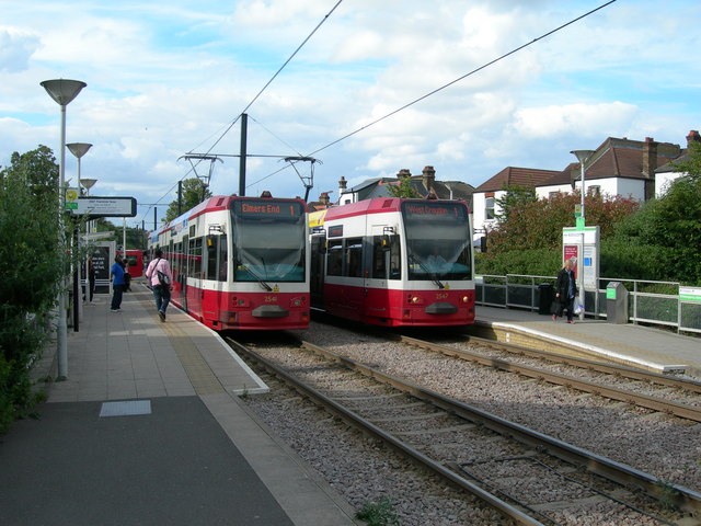
caption = Addiscombe tram stop, viewed from the Bingham Road end.
manager =Tramlink
zone = 5
locale =Addiscombe
borough =London Borough of Croydon
start =2000
platforms= 2Addiscombe tram stop is a
light rail stop in theLondon Borough of Croydon in the southern suburbs ofLondon .The tram stop is served by
Tramlink routes:cite web | title = Buses and trams from Addiscombe | publisher = Transport for London | url = http://www.tfl.gov.uk/tfl/gettingaround/maps/buses/pdf/addiscombe-11300.pdf | accessdate = 2007-02-01]
* 1 (Central Croydon toElmers End )
* 2 (Central Croydon toBeckenham )Bus stops adjacent to the tram stop provide interchange with the following bus services (as of January 2008):cite web | title = Buses and trams from Addiscombe | publisher = Transport for London | url = http://www.tfl.gov.uk/tfl/gettingaround/maps/buses/pdf/addiscombe-11300.pdf | accessdate = 2007-02-01]
* 289 –
Elmers End – Central Croydon – Purley;
* 312 –Norwood Junction – Central Croydon –South Croydon ;
* 367 –Bromley – Central Croydon;The tram stop is located between Bingham Road and Lower Addiscombe Road, on a section of line which follows the trackbed of the former
Woodside and South Croydon Railway . However the former railway was on an embankment at this point and crossed over both roads on bridges. During construction of Tramlink, the embankment was removed, the bridges replaced withlevel crossing s and the tram stop built at street level.The former Bingham Road halt on the Woodside and South Croydon Railway was formerly situated here. Its longer platforms also extended to the south of Bingham Road. The same railway's Addiscombe station was located on a branch line, about 500 metres to the west.cite book | first = John B. | last = Gent | title = Croydon's Transport Through the Ages | publisher = Croydon Natural History & Scientific Society Ltd | isbn = 090604717X]
References
External links
* [http://meltingpot.fortunecity.com/turkey/927/WSCR.html Woodside & South Croydon railway]
* [http://www.subbrit.org.uk/sb-sites/stations/b/bingham_road/index.shtml Bingham Road Station] pages at Subterranea Britannica
Wikimedia Foundation. 2010.