- Crawford, South Lanarkshire
-
Crawford is a village in South Lanarkshire, Scotland.
Crawford is close to the source of the River Clyde and the M74 motorway, fifty miles south east of Glasgow and fifty-three miles north west of Carlisle. It has a population of around 300 people, two hotels, a public house, a village shop and Post Office, church, and a school.
The village is close to an old Roman road and has links with Sir William Wallace (see Crawford Castle). Recent archaeological excavations have shown that this was the site of a Roman fort between 80 AD and 140 AD housing perhaps 300 soldiers.
Coordinates: 55°27′45″N 3°39′44″W / 55.46254°N 3.66218°W
Settlements in South Lanarkshire Towns Biggar · Blantyre · Bothwell · Cambuslang · Carluke · East Kilbride · Hamilton · Larkhall · Lanark · Lesmahagow · Rutherglen · Strathaven · Uddingston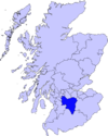
Villages and Hamlets Abington · Allanton · Ashgill · Auchengray · Auchenheath · Blackwood · Braidwood · Carnwath · Carstairs Junction · Carstairs Village · Cartland · Chapelton · Coalburn · Cobbinshaw · Coulter · Crawford · Crawfordjohn · Crossford · Dalserf · Dolphinton · Douglas · Dunsyre · Elsrickle · Forth · Garrion Bridge · Glassford · Kilncadzow · Kirkfieldbank · Kirkmuirhill · Law · Leadhills · Newbigging · Nerston · Pettinain · Quothquan · Ravenstruther · Rigside · Roberton · Rosebank · Sandford · Stonehouse · Symington · Tarbrax · Thankerton · Thorntonhall · Tillietudlem · Wiston · Woolfords · YieldshieldsCategories:- Villages in South Lanarkshire
- South Lanarkshire geography stubs

Wikimedia Foundation. 2010.