- U.S. Route 62 Business (Niagara Falls, New York)
-
U.S. Route 62 Business

Pine Avenue 
Map of Niagara Falls with US 62 Business highlighted in redRoute information Business route of US 62 Maintained by the city of Niagara Falls Length: 2.12 mi[4] (3.41 km) Existed: 2006[1] – present History: Designated NY 62A from early 1970s[2][3] to 2006[1] Major junctions West end:  NY 104 in Niagara Falls
East end:  US 62 in Niagara Falls
Highway system United States Numbered Highways
List • Bannered • Divided • ReplacedNumbered highways in New York
Interstate • U.S. • N.Y. (former) • Reference • County← US 62
NY 63  →
→U.S. Route 62 Business (US 62 Business) is a business route of US 62 located within the city of Niagara Falls, New York, in the United States. It follows Pine Avenue through downtown Niagara Falls, spanning 2.12 miles (3.41 km) between New York State Route 104 (NY 104) at its western terminus and US 62 at its eastern extent. Although it runs in a mostly east–west direction, it is signed as a north–south route due to US 62 being signed north–south as well within New York.
Pine Avenue was originally designated as part of NY 34 in 1924. It then became part of NY 18 after it replaced NY 34 in 1930. Ca. 1932, US 62 was extended into New York and overlapped NY 18 between Dayton and Niagara Falls. NY 18 was truncated to Lewiston, a village north of the city, in the early 1960s, making US 62 the sole occupant of Pine Avenue. US 62 was shifted onto its current alignment through the city later in the decade, allowing Pine Avenue to become New York State Route 62A in the early 1970s. NY 62A was redesignated as US 62 Business in 2006.
Contents
Route description
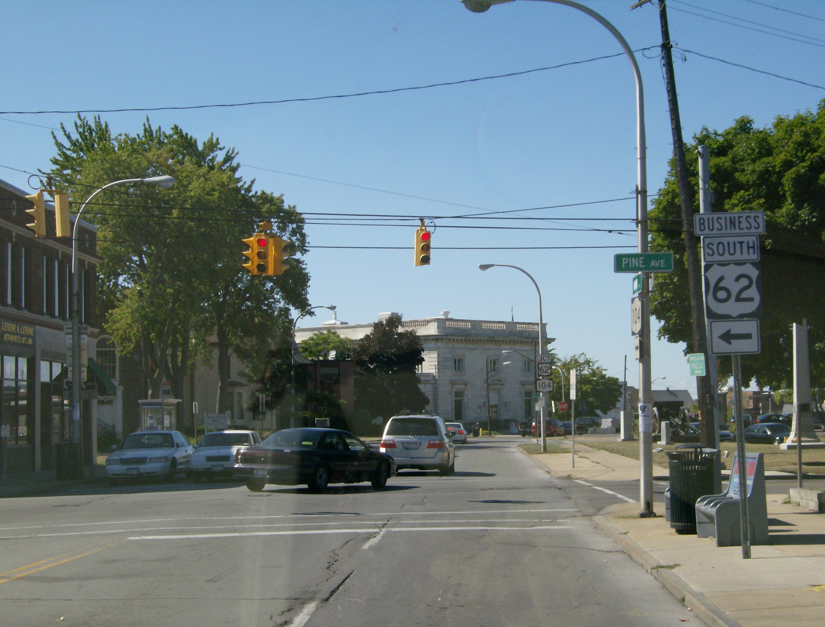
 Northern (western) terminus of US 62 Business at NY 104
US 62 Business begins at the intersection of Main Street (NY 104) and Pine Avenue in downtown Niagara Falls. Unlike the two streets—Walnut and Ferry Avenues—that carry US 62 through Niagara Falls to the south, Pine Avenue is a two-way street, the first such east–west street accessible from NY 104 heading north from the Rainbow Bridge. Heading east from NY 104, US 62 Business passes through a largely commercial neighborhood. At a signalized intersection with 7th Street two blocks from NY 104, the surroundings become residential in nature; however, the area reverts back to strictly commercial structures at 10th Street. Between 10th and Portage Road, a local north–south arterial, US 62 Business passes along the northern edge of the Niagara Falls Memorial Medical Center.[5]
Past Portage Road, US 62 Business runs past the northern grounds of the Niagara Arts and Cultural Center (the former location of Niagara Falls High School) as it enters a neighborhood of Niagara Falls known as "Little Italy", as denoted by a large overhead structure that spans the width of Pine Avenue. Although this area is mostly commercial as well, it features decorative elements not found west of Portage Road, such as stylized streetlights alongside the roadway. The district extends for 1.25 miles (2.01 km) eastward to Hyde Park Boulevard (NY 61), where another overhead sign denotes the eastern edge of Little Italy.[5]
The last segment of US 62 Business differs greatly from the remainder of the route. On its northern edge, US 62 Business is bounded by Hyde Park, a large city park surrounding Gill Creek; to the south is a fully residential neighborhood. It is during this stretch that Pine Street widens from two to four traffic lanes (while Pine is four lanes wide its entire length, from NY 104 to NY 61 the extra lanes are for parking). 0.34 miles (0.55 km) east of NY 61, US 62 Business breaks from its strictly east–west routing and curves south to meet US 62. US 62 Business northbound (west) begins at Walnut Avenue (US 62 north); however, US 62 Business south continues for another 0.25 miles (0.40 km) to the junction of Packard Road (US 62 south) and Niagara Falls Boulevard (bi-directional US 62).[5] All of US 62 Business is maintained by the city of Niagara Falls.[6]
History
Pine Avenue in Niagara Falls was originally designated as part of NY 34 when the first set of posted routes in New York were assigned in 1924.[7] In the 1930 renumbering of state highways of New York, NY 34 was replaced by an extended NY 18.[8] When US 62 was extended into New York ca. 1932, it overlapped NY 18 from Dayton to Niagara Falls. US 62 then ended at the junction of Pine Avenue and Main Street while NY 18 continued north on Main Street toward Lewiston.[9][10] This overlap remained in place until ca. 1962 when NY 18 was truncated to then-US 104 in Lewiston.[11][12]
US 62 remained routed on Pine Avenue until the mid-1960s when it was shifted south onto Walnut and Ferry Avenues, which had been transformed into a one-way couplet.[13][14] Its former routing on Pine Avenue was designated as NY 62A in the early 1970s.[2][3] This designation remained in place until 2006 when NY 62A was redesignated as US 62 Business by the American Association of State Highway and Transportation Officials at the request of the New York State Department of Transportation and the city of Niagara Falls.[1]
Major intersections
The entire route is in Niagara Falls, Niagara County.
Mile[4] Destinations Notes 0.00 NY 104 (Main Street)1.63  NY 61 (Hyde Park Boulevard)
2.12 US 62 (Niagara Falls Boulevard)1.000 mi = 1.609 km; 1.000 km = 0.621 mi References
- ^ a b c "US 62 Business – Establishment" (PDF). American Association of State Highway and Transportation Officials. 2006. http://cms.transportation.org/sites/route/docs/NY_rt62a_1.pdf. Retrieved April 3, 2009.
- ^ a b State of New York Department of Transportation (January 1, 1970) (PDF). Official Description of Touring Routes in New York State. http://www.greaternyroads.info/pdfs/state70.pdf. Retrieved April 3, 2009.
- ^ a b Shell Oil Company (1973). New York (Map). Cartography by H.M. Gousha Company (1973 ed.).
- ^ a b "2008 Traffic Volume Report for New York State" (PDF). New York State Department of Transportation. June 16, 2009. p. 124. https://www.nysdot.gov/divisions/engineering/technical-services/hds-respository/NYSDOT%20TVR%202008%20by%20Route.pdf. Retrieved January 31, 2010.
- ^ a b c Google, Inc. Google Maps – U.S. Route 62 Business (Niagara Falls, New York) (Map). Cartography by Google, Inc. http://maps.google.com/maps?f=q&source=s_q&hl=en&geocode=&sll=37.0625,-95.677068&sspn=48.688845,114.082031&ie=UTF8&ll=43.096471,-79.038606&spn=0.02134,0.072012&t=h&z=15. Retrieved April 3, 2009.
- ^ "Niagara County Inventory Listing" (CSV). New York State Department of Transportation. March 2, 2010. https://www.nysdot.gov/divisions/engineering/technical-services/hds-repository2/INV_2010-03-02_niagara.csv. Retrieved December 21, 2010.
- ^ "New York's Main Highways Designated by Numbers". The New York Times: p. XX9. December 21, 1924.
- ^ Dickinson, Leon A. (January 12, 1930). "New Signs for State Highways". The New York Times: p. 136.
- ^ Kendall Refining Company (1931). New York (Map). Cartography by H.M. Gousha Company.
- ^ Texas Oil Company (1932). Texaco Road Map – New York (Map). Cartography by Rand McNally and Company.
- ^ Sunoco (1961). New York and Metropolitan New York (Map). Cartography by H.M. Gousha Company (1961–62 ed.).
- ^ Esso (1962). New York with Sight-Seeing Guide (Map). Cartography by General Drafting (1962 ed.).
- ^ Mobil (1965). New York (Map). Cartography by Rand McNally and Company.
- ^ Esso (1968). New York (Map). Cartography by General Drafting (1969–70 ed.).
External links
Categories:- U.S. Route 62
- Transportation in Niagara Falls, New York
- Transportation in Niagara County, New York
- Bannered and suffixed U.S. Highways
- U.S. Highways in New York


Wikimedia Foundation. 2010.