- Morvern
-
- Not to be confused with Morven
Coordinates: 56°35′N 5°42′W / 56.59°N 5.7°W
Morvern Scottish Gaelic: A' Mhorbhairne 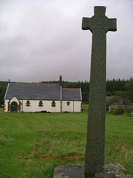
Kiel Church and the Morvern Cross, at Lochaline; Kiel is derived from Cille Choluimchille, church of Saint Columba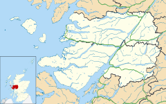
 Morvern
Morvern shown within the Lochaber areaPopulation 320 - Edinburgh 190 miles (road)
149 miles (via Corran ferry)- London 567 miles (road)
526 miles (via Corran ferry)Council area Highland Lieutenancy area Inverness Country Scotland Sovereign state United Kingdom Post town OBAN Postcode district PA80 Dialling code 01967 Police Northern Fire Highlands and Islands Ambulance Scottish EU Parliament Scotland UK Parliament Ross, Skye and Lochaber Scottish Parliament Inverness East, Nairn and Lochaber List of places: UK • Scotland • Morvern is a peninsula in south west Lochaber, on the west coast of Scotland. The name is derived from the Gaelic A' Mhorbhairne (the Sea-Gap). The highest point is the summit of the Corbett Creach Bheinn which reaches 2,800 feet (850 m) in elevation.
Morvern is approximately 250 square miles (650 km2) with a current population of about 320.
Contents
History
Morvern was formerly known as Kinelvadon, which William J. Watson takes to be from Cineal Bhaodain, that is that lands of the Cenél Báetáin, a division of the Cenél Loairn named after Báetán, a putative great-grandson of Loarn mac Eirc. The Senchus fer n-Alban states that "Baotan has twenty houses".
The ruined Ardtornish Castle was in the possession of Somerled in the 12th century and then the Lords of the Isles, whose ownership was recalled in a poem of the same name by Sir Walter Scott. Kinlochaline Castle was once the seat of the MacInnes clan. It was largely destroyed by the army of Oliver Cromwell and restored in 1890.
Before the Highland clearances the population of Morvern was about 2500.
The history of the parish of Morvern in the nineteenth century has been detailed in Philip Gaskell's Morvern Transformed.
Some residents of St Kilda were relocated to Lochaline, the main village of Morvern, when the island was evacuated in 1930.
Present day
Ferries depart from Lochaline, at 56°32′12″N 05°46′29″W / 56.53667°N 5.77472°W, to the Isle of Mull. Rahoy has a deer farm supported by Highlands and Islands Enterprise. The Morvern Community Development Company (MCDC), the local development trust, was established in 1999. It aims to provide increased employment opportunities, particularly for the young, and to create a wind energy project. In 2010 it was announced that MCDC would receive support for a full-time development worker from Highlands and Islands Enterprise.[1]
The closure of the silica mine at Lochaline was announced in December 2008, with the loss of 11 jobs.[2]
Ardtornish, one of the largest estates in the area, received planning permission in 2010 for a new "township" of 20 houses at Achabeag, two miles west of Lochaline.[3]
See also
- Ardgour
- Ardnamurchan
- Glensanda
- Moidart
- Sunart
Notes
- ^ "HIE aim to bolster rural fragility" Local People Leading. Retrieved 24 June 2010.
- ^ "Highland community faces up to future after mine closure" Local People Leading. Retrieved 5 February 2009.
- ^ "Planning decision enables major new investment in Morvern" Ardtornish Estate. Retrieved 24 June 2010.
References
- Gaskell, Philip (1968) Morvern Transformed: A Highland Parish in the Nineteenth Century. Cambridge University Press.
- Maclean, Charles (1972) Island on the Edge of the World. Edinburgh. Canongate.
- Murray, W.H. (1977) The Companion Guide to the West Highlands of Scotland. London. Collins.
Traditional provinces and districts of Scotland Major districts (former counties, provincial lordships and rural deaneries) The Aird · Annandale · Angus · Argyll · Atholl · Boyne · Buchan · Badenoch · Breadalbane · Caithness · Carrick · Clydesdale (or Strathclyde) · Cowal · Cunningham · Desnes · Eskdale · Farines · Fife · Fothriff · Galloway · Garioch · Garmoran · The Glenkens · Gowrie · Kintyre · Knapdale · Kyle · Lauderdale · Lennox · Liddesdale · Lochaber · Lorn · Lothian · Mar · Mearns · Menteith · Merse · Moray · Nithsdale · The Rhinns · Ross (Easter and Wester) · Stormont · Strathavon · Strathbogie · Strathearn · Strathgryfe · Strathnaver · Strathspey · Sutherland · Teviotdale · Tweeddale
Minor districts Applecross · Appin · Ardgour · Ardmeanach · Ardnamurchan · Assynt · Avondale · Balquhidder · Benderloch · The Black Isle · Braemar · Coigach · Cromar · Cromdale · Douglasdale · Durness · Eddrachilles · Enzie · Ettrickdale · Ewesdale · Formartine · Gairloch · Glen Albyn · Glen Almond · Glen Cassley · Glen Clova · Glen Dochart · Glenelg · Glen Esk · Glengarry · Glen Lethnot · Glen Lyon · Glen Moriston · Glen Orchy · Glen Prosen · Glenshee · Glen Spean · Glen Urquhart · Gruinard · Howe of Fife · Howe of the Mearns · Kintail · Kintyre · Knoydart · Lochalsh · Loch Broom · Locheil · The Machars · Midmar · Moidart · Morar · Morven · Muir of Ord · Rannoch Moor · Rhinns of Kells · Strathallan · Strathardle · Strathbran · Strathbraan · Strathcarron (Forth) · Strathcarron (Oykel) · Strathconon · Strathdearn · Strathdeveron · Strathdee (Deeside) · Strathdon · Strathfarrar · Strath Gartney · Strathglass · Strathisla · Strathmore · Strath of Kildonan · Strath Oykel · Strath Tay · Strathyre · Sunart · Trossachs
Insular districts
For smaller islands, usually districts in their own right, see List of Scottish islandsBorder Areas Settlements Ach' An Todhair • Achaphubuil • Acharacle • Achnaha • Achluachrach • Achriabhach • Ardechive • Ardshealach • Arisaig • Back of Keppoch • Ballachulish • Banavie • Blaich • Cleadale • Corpach • Corran • Druimarben • Fort William • Glenborrodale • Glencoe • Glenfinnan • Glenuig • Inverie • Kilchoan • Kilmory • Kinlochleven • Lochaline • Mallaig • Morar • Ockle • Onich • Portuairk • Roybridge • Sanna • Spean Bridge • StrontianGeography Landmarks Glencoe House • Mingarry Castle • Castle TioramTransport Categories:- Lochaber
- Peninsulas of Scotland


Wikimedia Foundation. 2010.