- Narragansett Bay
-
Coordinates: 41°36′N 71°21′W / 41.6°N 71.35°W
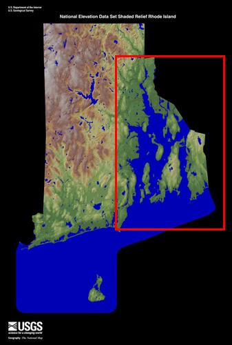
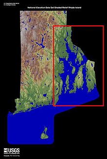 Narragansett Bay, boxed in red, in relation to Rhode Island
Narragansett Bay is a bay and estuary on the north side of Rhode Island Sound. Covering 147 mi2 (380 km2), the Bay forms New England's largest estuary, which functions as an expansive natural harbor, and includes a small archipelago.[1] This bay is mostly within the state of Rhode Island and Providence Plantations, but small parts of it extend into Massachusetts.
Of over thirty islands in the Bay, the three largest ones are Aquidneck Island, Conanicut Island, and Prudence Island.[2] Bodies of water that are part of Narragansett Bay include the Sakonnet River; Mount Hope Bay; and the southern, tidal part of the Taunton River. The bay opens on Rhode Island Sound — Block Island lies less than 20 miles (32 km) southwest of its opening — and the Atlantic Ocean. Narragansett Bay can be seen in NOAA chart 13221
Contents
Populations
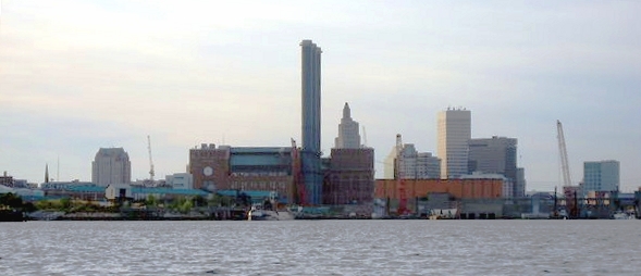
 Providence, at the head of the Narragansett Bay
 Fall River, at the Northeast part of the Bay
Providence, the Rhode Island state capital and largest city, sits on the west side of the head of the northernmost arm of the bay. Many of Providence's suburbs, including Warwick and Cranston, are also on the bay. Newport, the home of the United States Naval War College, the Naval Undersea Warfare Center, and a major United States Navy training center, is located at the south end of Aquidneck Island, on the ocean. The city of Fall River, Massachusetts is located at the confluence of the Taunton River and Mount Hope Bay, which form the northeasternmost part of Narragansett Bay. The southwest side of the bay include the seaside tourist towns of Narragansett and Wickford. Quonset Point, south of Warwick, gives its name to the Quonset hut. Roger Williams University is located in Bristol, Rhode Island on land overlooking the Bay.
Glacial origins
Narragansett Bay is a ria that consists of a series of flooded river valleys formed of dropped crustal blocks in a horst and graben system[3] that is slowly subsiding between a still-shifting fault system;[4] however, the estuary system is vast compared to the present flow of the three small rivers that enter the bay, in the northeast, the Taunton River and in the northwest, the Providence and Seekonk Rivers. The present shape of Narragansett Bay is instead the result of the most recent glaciation of New England, under the edges of the Laurentide ice sheet at the Last Glacial Maximum, about 18,000 B.P.[5] Sea level was lowered so much that the continental shelf was exposed, under its weight of ice, and the glacier calved into the Atlantic at its foredge south of Block Island. Glaciers flowing through a geologically old sedimentary basin carved channels through the younger sediments and exposed much older bedrock. North-to-south cuts gouged by the ice can be seen clearly on the map: they form the West Passage that separates Conanicut Island from the western mainland and the East Passage that now separates Conanicut Island from Aquidneck Island.
As the ice stalled, then retreated, the region became ice-free by about 14,000 B.P.[6] A complicated sequence of marine ingression and isostatic rebound flooded and emptied the landscape. A fresh water proglacial lake called by geologists Lake Narragansett formed about 15,500 B.P.,[7] impounded behind terminal moraines:[8] the lake lasted about 500 years, leaving the powerful flow of a post-glacial river running down its north-south axis. Then salt water filled the valley, as rising sea levels permanently flooded the area.
Early history
The first visit by Europeans to the bay was probably in the early 16th century. At the time, the area around the bay was inhabited by two different and distinct groups of natives: the Narragansetts occupied the west side of the bay, and the Wampanoag lived on the east side, occupying the land east to Cape Cod.
It is accepted by most historians that first contact by Europeans was made by Giovanni da Verrazzano, an Italian explorer who entered the bay in his ship La Dauphine in 1524 after visiting New York Bay. Verrazzano called the bay Refugio, the "Refuge". The bay has several entrances, however, and the exact route of his voyage and the location where he laid anchor is still a subject of dispute among historians, leading to a corresponding uncertainty over which tribe made contact with him.[9] Verrazzano reported that he found clearings and open forests suitable for travel "even by a large army," a far cry from the impenetrable tangle that resulted when the English suppressed controlled burns in the seventeenth century.[10]
Later, in 1614, the bay was explored and mapped by the Dutch navigator Adriaen Block, after whom nearby Block Island is named. The first recorded European settlement was in the 1630s. Roger Williams, a dissatisfied member of the Plymouth Colony, moved into the area around the year 1636. He made contact with the Narragansett sachem called Canonicus by the Europeans, and set up a trading post on the site of Providence. At the same time, the Dutch had established a trading post approximately 12 miles (20 km) to the southwest which was under the authority of New Amsterdam in New York Bay.
In 1643, Williams traveled to England and was granted a charter for the new colony of Rhode Island. He also wrote a dictionary of the Narragansett language, Keys to the Indian Language, which was published in England that same year.
The Gaspée Affair, an important naval event of the American Revolution, occurred in 1772 in the bay; it involved the capture of the HMS Gaspee, a British ship. The American victory contributed to the eventual start of the war at the Battles of Lexington and Concord in Massachusetts three years later. The event is celebrated in Warwick as the Gaspee Days Celebration[11] in June, which event includes a symbolic recreation of the burning of the ship.
Captain James Cook's HMS Endeavour is believed to have been scuttled in the bay, as part of a blockade by the British, whose occupation of Newport was threatened by a fleet carrying French soldiers in support of the Continental Army.
Roger Williams and other early colonists named many of the islands in the bay. To remember the names, colonial school children often recited the poem: "Patience, Prudence, Hope and Despair. And the little Hog over there."[12]
Rivers
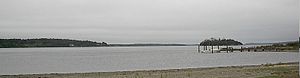 The Sakonnet River, a saltwater strait that forms part of Narragansett Bay
 Providence from the Providence River at the head of Narragansett Bay
- Blackstone River, Woonsocket, Cumberland, Lincoln, Central Falls & Pawtucket, RI
- Seekonk River, Pawtucket, East Providence & Providence, RI
- Ten Mile River, Pawtucket & East Providence, RI
- Moshassuck River, Providence, RI
- Woonasquatucket River, Providence, RI
- Providence River, Providence, Cranston, East Providence & Barrington, RI
- Pawtuxet River, Cranston & Warwick, RI
- Potowomut River, aka Greene River, Warwick & North Kingstown, RI
- Quequechan River, aka Quiquechan River, Fall River, MA
- Barrington River, Barrington, RI
- Palmer River, Barrington & Warren, RI
- Warren River, Warren & Barrington, RI
- Taunton River, Tiverton, RI & Fall River, MA
- Sakonnet River, Tiverton, Little Compton, Portsmouth & Middletown, RI
Narragansett Bay West Passage—heading north
- Franklin Hollow, Jamestown
- Dutch Island Harbor, Jamestown
- Sheffield Cove, Jamestown
- The Hummocks Cove, North Kingstown
- The Narrows, North Kingstown
- Bissel Cove, North Kingstown
- Duck Cove, North Kingstown
- Wickford Harbor, North Kingstown
- Allen Harbor, North Kingstown
- Hope Island Cove, North Kingstown
- West Passage between Patience & Prudence Islands
- Sheep Pen Cove, Patience Island
- Coggeshell Cove, Prudence Island
- Potowomut River, aka Greene River, North Kingstown & Warwick
- Greenwich Bay, Warwick & East Greenwich
- Greenwich Cove, East Greenwich
- Apponaug Cove, Warwick
- Buttonwoods Cove, Warwick
- Brush Neck Cove, Warwick
- Warwick Cove, Warwick
Providence River—heading northwest then southeast
- Old Mill Cove, Warwick
- Occupessatuxet Cove, Warwick
- Passeonkquis Cove, Warwick
- Pawtuxet Cove, Warwick & Cranston
- Stillhouse Cove, Cranston
- Providence Harbor, Providence & East Providence
- Seekonk River, Providence, Pawtucket, East Providence
- Pawtucket River, Pawtucket
- Omega Pond, East Providence
- Watchemoket Cove, East Providence
- Bullock Cove, East Providence & Barrington
- Allins Cove, Barrington
- Smith's Cove, Barrington
- Warren River, Barrington & Warren
- Barrington River, Barrington
- One Hundred Acre Cove, Barrington
- Palmer River, Barrington, Warren & Swansea, Massachusetts
- Belcher Cove, Warren
- Usher Cove, Bristol
East Passage—going south
- Bristol Harbor, Bristol
- Mill Pond, Bristol
- Walker's Cove, Bristol
- Potter Cove, Prudence Island
- Cranston Cove, Jamestown
- Potter Cove, Jamestown
- East Ferry, Jamestown
- Fort Cove, Jamestown
- West Cove, Jamestown
- Hull Cove, Jamestown
- Coggeshall Cove, Portsmouth
- Little Harbor, Melville, Portsmouth
- Coddington Cove, Middletown & Newport
- Coasters Harbor, Newport
- Newport Harbor, Newport
- Brenton Cove, Newport
- Castle Hill Cove, Newport
- Church Cove, Bristol
- Bristol Narrows, Bristol & Warren
- Kickemuit River, Bristol & Warren
- Chase Cove, Warren
- Hog Island Cove, Bristol
Sakonnet River—going south
- The Hummocks, Portsmouth
- The Cove, Portsmouth
- Blue Bill Cove, Portsmouth
- Old Orchard Cove, Portsmouth
- Long Neck Cove, Portsmouth
- Quaket River, Tiverton
- Nannaquaket Pond
- Sapowet Cove, Tiverton
- Fogland Cove, Tiverton
- Church Cove, Little Compton
Pawcatuck River—heading upriver
- Little Narragansett Bay, Westerly
- The Kitchen Cove, Westerly
- Watch Hill Cove, Westerly
- Potter Cove, Westerly
- Colonel Willie Cove, Westerly
- Babcock Cove, Westerly
- Mastuxet Cove, Westerly
- Thompson Cove, Westerly
South Coast—from west to east
- Weekapaug Pond, Westerly
- Quonochontaug Pond, Westerly & Charlestown
- Ninigret Pond, Charlestown
- Point Judith Pond, South Kingstown & Narragansett
- Potter Pond, South Kingstown
- Pettaquamscutt River, aka Narrow River, South Kingstown, Narragansett & North Kingstown
- Mackerel Cove, Jamestown
- Goose Neck Cove, Newport
- Sheep Point Cove, Newport
- Easton Bay, Newport & Middletown
- Sachuest Bay, Middletown
- Sakonnet Harbor, Little Compton
- Little Pond Cove, Little Compton
Block Island—clockwise from north
- Cow Cove, New Shoreham
- Isaiahs Gully, New Shoreham
- Balls Cove, New Shoreham
- Old Harbor, New Shoreham
- Green Hill Cove, New Shoreham
- Tilson Cove, New Shoreham
- Cat Rock Cove, New Shoreham
- Sand Bank Cove, New Shoreham
- Lighthouse Cove, New Shoreham
- Corn Cove, New Shoreham
- Split Rock Cove, New Shoreham
- Stevens Cove, New Shoreham
- Dories Cove, New Shoreham
- Grace Cove, New Shoreham
- Dead Man's Cove, New Shoreham
- Great Salt Pond, New Shoreham
- Cormorant Cut, New Shoreham
- Old Breach Cove, New Shoreham
- New Harbor, New Shoreham
- Trims Pond, New Shoreham
- Logwood Cove, New Shoreham
Notes
- ^ ""Abundance and Distribution of Ichthyoplankton in Narragansett Bay, Rhode Island, 1989-1990" Estuaries, Vol. 22, No. 1 (Mar., 1999), pp. 149-163". Links.jstor.org. http://links.jstor.org/sici?sici=0160-8347(199903)22%3A1%3C149%3AAADOII%3E2.0.CO%3B2-6. Retrieved 2010-04-03.
- ^ "The Islands - City of Providence Website". Providenceri.com. http://www.providenceri.com/NarragansettBay/the_islands.html. Retrieved 2010-04-03.
- ^ Probably forming in Pennsylvanian times, according to Robert L. McMaster, Jelle de Boer, and Barclay P. Collins, "Tectonic development of southern Narragansett Bay and offshore Rhode Island", Geology 8.10 (October 1980:496–500) (On-line abstract).
- ^ The faults produce earthquakes upon occasion, according to the USGS: "Rhode Island Earthquake History".
- ^ "Geological History of Jamestown, Rhode Island: Glaciation".
- ^ "Geological History of Jamestown, Rhode Island: The Holocene epoch.
- ^ USGS: Surficial Geology in Central Narragansett Bay, Rhode Island.
- ^ Sediments reach up to 134-m thick near the mouth of Narragansett Bay (USGS website).
- ^ [1], [2].
- ^ W. Conon, Changes in the Land: Indians, Colonists and the Ecology of New England (New York) 1983.
- ^ DRC. "Gaspee Days Committee". Gaspee.com. http://www.gaspee.com/. Retrieved 2010-04-03.
- ^ "Prudence Island Lighthouse History". Lighthouse.cc. http://lighthouse.cc/prudence/history.html. Retrieved 2010-04-03.
External links
- Narragansett Bay Research Reserve on Prudence Island
- Narragansett Bay Shipping
- Narragansett Bay: A Friend's Perspective
- Narragansett Bay.Org
- Save The Bay
- Narragansett Bay Estuary Program
- 1777 Chart/Map of Narragansett Bay by Charles Blaskowitz and William Faden at DavidRumsey.com
Narragansett Bay Islands Aquidneck Island · Conanicut Island · Prudence Island · Patience Island · Hog Island · Dutch Island · Coaster's Harbor Island · Cornelius Island · Despair Island · Dyer Island · Fox Island · Goat Island · Gould Island · Greene Island · Hope Island · Lime Rock · Rabbit Island · Rock Island · Rose Island · Starvegoat Island · Whale Rock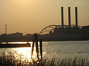
Major rivers Cities & towns Providence · Newport · Cranston · Warwick · East Providence · Barrington · Bristol · East Greenwich · Jamestown · Middletown · Narragansett · North Kingstown . Portsmouth · WarrenBridges –
Categories:- Bays of Rhode Island
- Bays of Massachusetts
- Estuaries of Rhode Island
- Landforms of Bristol County, Rhode Island
- Landforms of Kent County, Rhode Island
- Landforms of Newport County, Rhode Island
- Landforms of Providence County, Rhode Island
- Landforms of Washington County, Rhode Island


Wikimedia Foundation. 2010.