- New York State Route 272
-
NYS Route 272
County Line Road 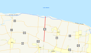
Map of Monroe and Orleans Counties with NY 272 highlighted in redRoute information Maintained by NYSDOT Length: 7.58 mi[2] (12.20 km) Existed: 1930[1] – present Major junctions South end:  NY 104 on Murray–Clarkson town line
 Lake Ontario Parkway on Kendall–Hamlin town line
North end: Lake Ontario shoreline on Kendall–Hamlin town line Location Counties: Orleans, Monroe Highway system Numbered highways in New York
Interstate • U.S. • N.Y. (former) • Reference • County←  NY 271
NY 273  →
→New York State Route 272 (NY 272) is a north–south state highway in the western portion of New York in the United States. It extends for just over 7.5 miles (12.1 km) along the Orleans–Monroe county line from an intersection with NY 104 in Clarkson to the Lake Ontario shoreline just north of an interchange with the Lake Ontario State Parkway in the Hamlin hamlet of Troutburg. The route is two lanes wide for its entire length and passes through mostly rural areas, save for the hamlet of Morton at a junction with NY 360. NY 272 was assigned as part of the 1930 renumbering of state highways in New York and has not been altered since.
Contents
Route description
NY 272 begins at an intersection with NY 104 (Ridge Road) on the Orleans–Monroe county line, which also separates the towns of Clarkson and Murray. The two-lane route heads north, passing through open fields and over Sandy Creek to intersect NY 18 at Kendall Mills, a hamlet in the town of Hamlin. NY 18 briefly overlaps NY 272 northward but veers west off the county line and into Kendall south of the dual-town hamlet of Morton. The number of homes and businesses along NY 272 begins to rise during the stretch between Kendall Mills and Morton.[3]
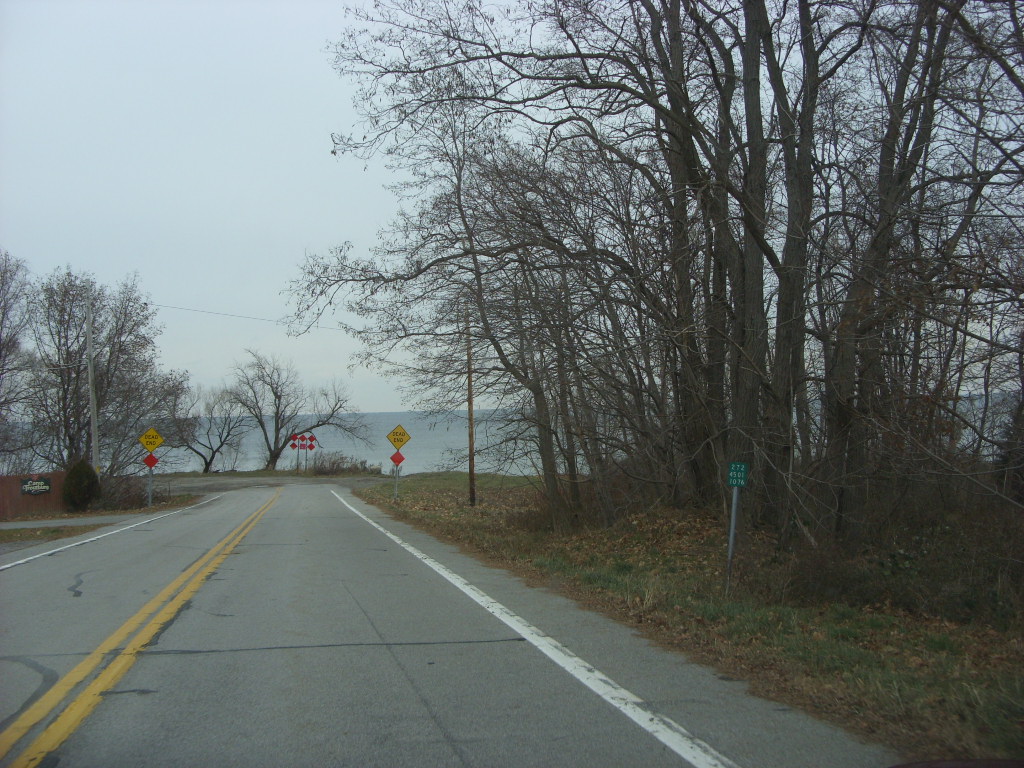
 The northern terminus of NY 272 at Lake Ontario in Troutburg. The final reference marker is visible to the right
NY 272 directly serves Morton, a small community situated equally in the town of Kendall and the town of Hamlin. In the center of Morton, NY 272 intersects NY 360, which approaches NY 272 from the Monroe County side. North of Morton, the amount of development along the road declines sharply as it heads toward Lake Ontario. NY 272 meets the Lake Ontario State Parkway at an interchange south of the shoreline near the west end of Hamlin Beach State Park. This is the last signed highway that NY 272 intersects;[3] however, NY 272 officially continues to the lakeside hamlet of Troutburg in the town of Hamlin, where it terminates at a dead end at the southern lakeshore.[2]
NY 272 is one of only two state highways in New York that are located wholly along a county boundary. Incidentally, the other one is NY 269 on the other side of Orleans County, which delimits the boundary between Orleans and Niagara Counties.[4]
History
The portion of the Orleans–Monroe county line road north of Ridge Road was added to the state highway system in stages during the late 1900s and early 1910s. The section north of the Clarkson–Hamlin town line cost $39,531.05 (equivalent to $963,094 in 2011) to improve to state highway standards and was accepted into the system on December 1, 1909, as the unsigned State Highway 398 (SH 398). To the south, the piece between Ridge Road and the south end of SH 398 cost $20,199.14 (equivalent to $447,374 in 2011) to bring up to standards and was included in the system on November 12, 1913, as SH 588.[5][6] Neither SH 398 nor SH 588 were assigned a posted designation until the 1930 renumbering of state highways in New York, when they were collectively designated as NY 272.[1][7]
Major intersections
Location Mile[2] Destinations Notes Murray–Clarkson town line 0.00 NY 104Kendall–Hamlin town line 3.26  NY 18 east
Southern terminus of NY 18 / NY 272 overlap 4.24 NY 18 westNorthern terminus of NY 18 / NY 272 overlap 5.02  NY 360
Hamlet of Morton; western terminus of NY 360 7.32 Lake Ontario Parkway7.58 Dead end at Lake Ontario Hamlet of Troutburg 1.000 mi = 1.609 km; 1.000 km = 0.621 mi References
- ^ a b Standard Oil Company of New York (1930). Road Map of New York (Map). Cartography by General Drafting.
- ^ a b c "2008 Traffic Volume Report for New York State" (PDF). New York State Department of Transportation. June 16, 2009. p. 202. https://www.nysdot.gov/divisions/engineering/technical-services/hds-respository/NYSDOT%20TVR%202008%20by%20Route.pdf. Retrieved February 1, 2010.
- ^ a b Yahoo! Inc. Yahoo! Maps – overview map of NY 272 (Map). Cartography by NAVTEQ. http://maps.yahoo.com/#mvt=h&lat=43.308282&lon=-77.995885&zoom=13&q1=43.254754%2C-77.996605&q2=43.28822%2C-77.995661&q3=43.328067%2C-77.995318&q4=43.364909%2C-77.995747. Retrieved November 13, 2010.
- ^ I Love New York (2009). New York State Map (Map). Cartography by Map Works.
- ^ New York State Department of Highways (1920). Report of the State Commissioner of Highways. Albany, New York: J. B. Lyon Company. pp. 224, 232. http://books.google.com/books?id=Sj4CAAAAYAAJ&pg=PA224. Retrieved November 13, 2010.
- ^ Consumer Price Index (estimate) 1800–2008. Federal Reserve Bank of Minneapolis. Retrieved December 7, 2010.
- ^ Standard Oil Company of New York (1929). New York in Soconyland (Map). Cartography by General Drafting.
External links
Categories:- State highways in New York
- Transportation in Orleans County, New York
- Transportation in Monroe County, New York


Wikimedia Foundation. 2010.