- Operation Meghdoot
-
Operation Meghdoot Part of Siachen Conflict 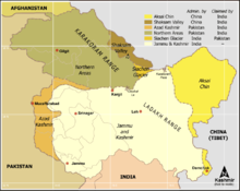
Siachen Glacier, Ladakh and Karakoram areas.Date 13 April 1984 Location Siachen Glacier, a disputed and undemarcated region of Kashmir Result Tactical and strategic Indian victory. Territorial
changesIndia holds all of the Siachen Glacier and its tributary glaciers.[1][2][3][4] Belligerents 
India
PakistanIndo-Pakistani wars and conflictsOperation Meghdoot was the name given to the attack launched by the Indian Military to capture the Siachen Glacier in the disputed Kashmir region, precipitating the Siachen Conflict. Launched on 13 April 1984, this military operation was unique as the first assault launched in the world's highest battlefield. The military action eventually resulted in Indian troops managing to gain control of the entire Siachen Glacier. Today, the occupation of locations along what is known as the Actual Ground Position Line (AGPL) continues to be known as Operation Meghdoot, with up to 10 Infantry Battalions each of the Indian Army and Pakistani Army actively deployed in altitudes up to 6,400 metres (21,000 ft).
Contents
Cause of conflict
The Siachen Glacier became a bone of contention following a vague demarcation of territory as per the Simla Agreement of 1972, which did not exactly specify who had authority over the Siachen Glacier area. As a result of this, both nations lay claim to the barren land. In the 1970s and early 80s, Pakistan permitted several mountaineering expeditions to climb the peaks in the Siachen region. This served to reinforce their claim on the area as these expeditions arrived on the glacier with a permit obtained from the Government of Pakistan. In 1978 the Indian Army also allowed mountaineering expeditions to the glacier, approaching from its side. The most notable one was the one launched by Colonel N. Kumar of the Indian Army, who mounted an Army expedition to Teram Kangri. Subsequently, due to this Indian Army expedition, the issue was aggravated and turned into a conflict, Siachen Conflict.
Notably, when Pakistan gave permission to a Japanese expedition to scale an important peak (Rimo I) in 1984, it further led to emergence of suspected thoughts of Indian Government. The peak, located east of the Siachen Glacier, also overlooks the northwestern areas of the Aksai Chin area which is occupied by China but claimed by India. The Indian military hypothetically believed that such an expedition could further a link for a trade route from the southwestern (Pakistani) to the northeastern (Chinese) side of the Karakoram Range and eventually provide a strategic, if not tactical, advantage to the Pakistani Armed Forces.
The operation
The Indian Military decided to take action to stop future expeditions from the Pakistani side and eventually to prevent Pakistan from staking its claim on the glacier. Accordingly, the Indian military brought to the glacier area troops from Northern Ladakh region as well as some paramilitary forces. Most of the troops had already been acclimatized to the extremities of the glacier after having been sent on a training expedition to Antarctica in 1982. Pakistan, meanwhile, felt that the Indians were planning to capture key ridges and passes near the glacier after the Indian Army's mountaineering expedition and accordingly decided to send its own troops to the glacier.
On 13 April 1984, the Indian Army made its move onto the glacier to defend the territory and the peaks and passes around it when it launched "Operation Meghdoot". The operation was launched under the command of Lieutenant General P N Hoon, the then army commander of the Indian Army's Northern Command based at Udhampur in Jammu & Kashmir in India. The operation was also based on intelligence inputs that Pakistan was also preparing for an action in these areas. Reportedly the operation pre empted Pakistani Army by about 4 days, as intelligence reported that Pakistan was to launch an operation on 17 April 1984. Named after the divine cloud messenger (Meghaduuta) in a Sanskrit play, the operation involved the airlifting of Indian Army soldiers by the Indian Air Force (IAF) and dropping them in the glacial area. The IAF used planes such as the Il-76, An-12 and An-32 to transport stores and troops as well to airdrop supplies to high altitude airfields. Helicopters like Mi-17, Mi-8, Chetak and Cheetah carried provisions and personnel to areas near hitherto unscaled peaks. Approximately 300[5] troops were soon up on the important peaks and passes of the glacier. By the time Pakistan troops managed to get into the immediate area, they found that the Indian troops had occupied the major mountain passes on the Saltoro Ridge west of Siachen Glacier[5]. Handicapped by the altitude and the limited time, Pakistan could only manage to control the Saltoro Ridge's western slopes and foothills despite the fact that Pakistan possessed more accessible routes to the area[5], unlike Indian access to the Siachen which was largely reliant on air drops[5].
In his memoirs, former Pakistani president, General Pervez Musharraf states that Pakistan lost almost 900 sq mi (2,300 km2) of territory.[6] TIME states that the Indian advance captured nearly 1,000 sq mi (2,600 km2) of territory claimed by Pakistan.[7] Camps were soon converted to permanent posts by both countries. The number of casualties on both sides during this particular operation is not known.
Aftermath
There are divergent views on the strategic value of the Operation. Some view it as a futile capture of non-strategic land which antagonized relations between India & Pakistan. Others consider the operation to be a "daring" success by the Indian Military and ensured that the Indian military held tactical high ground on the strategic Saltoro Ridge just west of the glacier, albeit at a high cost. The Indian Army currently controls all of the 70 kilometres (43 mi) long Siachen Glacier and all of its tributary glaciers, as well as the three main passes of the Saltoro Ridge immediately west of the glacier, Sia La, Bilafond La, and Gyong La, thus holding onto the tactical advantage of high ground.[8].[9].
The operation and the continued cost of maintaining logistics to the area is a major drain on both militaries. Pakistan launched an all out assault in 1987 and again in 1989 to capture the ridge and passes held by India. The first assault was headed by then-Brigadier-General Pervez Musharraf (later President of Pakistan) and initially managed to capture a few high points before being beaten back. Later the same year, Pakistan lost at least one major Pakistani post, the "Quaid", which came under Indian control as Bana Post, in recognition of Subedar Major Bana Singh who launched a daring daylight attack, codenamed "Operation Rajiv", after climbing 1,500 ft (460 m) of ice cliff. The only Param Vir Chakra (PVC) — the highest gallantry award of India — in the ongoing battle was awarded to then Naib Subedar Bana Singh who was instrumental in capturing the post. Bana Post is the highest battlefield post in the world today at a height of 22,143 feet (6,749 m) above sea level.[1][2] The second assault in 1989 was also unsuccessful as the ground positions did not change. The loss of most of the Siachen area and the subsequent unsuccessful military forays prompted Benazir Bhutto to taunt Zia ul Haq that he should wear a burqa as he had lost his manliness.[10]
Operation Meghdoot was seen by some as the blueprint behind the Kargil War in 1999 when Pakistan backed guerrillas and paramilitary forces covertly occupied the Kargil region. It is said that Operation Meghdoot was the inspiration for this abortive operation in Kargil launched by Pakistan later in 1999. Despite this, some obvious similarities do exist between Siachen and Kargil, including their preemptive nature and the tactical advantage held by the entity who holds the heights. But while Operation Meghdoot was launched in an area of ambiguous border demarcation, the Line of Control in the Kargil region is clearly demarcated and therefore India received complete international support during the Kargil episode.
Casualties
No reliable data available. However, both sides have taken most of their casualties from the weather and the terrain. A large number of soldiers from both sides have been lost due to frostbite, high altitude sickness and falling into a crevasse during patrols.
See also
- Siachen Glacier
- Operation Safed Sagar
- Jammu and Kashmir
- Northern Areas
- Actual Ground Position Line
Notes
- ^ See http://www.bharat-rakshak.com/MONITOR/ISSUE6-1/Siachen.html for perhaps the most detailed treatment of the geography of the conflict, including its early days, and under section "3." the current status of control of Gyong La, contrary to the oft-copied misstatement in the old error-plagued summary at http://www.globalsecurity.org/military/world/war/siachen.htm
- ^ See http://www.hinduonnet.com/fline/fl2304/stories/20060310001704400.htm for a detailed, current map.
- ^ "Indians have been able to hold on to the tactical advantage of the high ground. Most of India's many outposts are west of the (Siachen) Glacier along the Saltoro Range. Bearak, Barry (23 May 1999). "THE COLDEST WAR; Frozen in Fury on the Roof of the World". The New York Times. http://query.nytimes.com/gst/fullpage.html?res=9807EFDA1431F930A15756C0A96F958260&sec=&spon=&&scp=1&sq=%22May%2023,%201999%22%20%22Roof%20of%20the%20World%22&st=cse. Retrieved 2009-02-20.
- ^ In an academic study with detailed maps and satellite images, co-authored by brigadiers from both the Pakistani and Indian military, pages 16 and 27: "Since 1984, the Indian army has been in physical possession of most of the heights on the Saltoro Range west of the Siachen Glacier, while the Pakistan army has held posts at lower elevations of western slopes of the spurs emanating from the Saltoro ridgeline. The Indian army has secured its position on the ridgeline." Hakeem, Asad; Gurmeet Kanwal, Michael Vannoni, Gaurav Rajen (2007-09-01). "Demilitarization of the Siachen Conflict Zone". Sandia Report. Sandia National Laboratories, Albuquerque, NM, USA. http://www.cmc.sandia.gov/cmc-papers/sand20075670.pdf. Retrieved 2009-02-20.
- ^ a b c d "War at the Top of the World". Time. 7 November 2005. http://www.time.com/time/asia/covers/501050711/story2.html.
- ^ Pervez Musharraf (2006). In the Line of Fire: A Memoir. Free Press. ISBN 0743283449.(pp. 68-69)
- ^ The Himalayas War at the Top Of the World 31 July 1989 - TIME
- ^ http://www.bharat-rakshak.com/MONITOR/ISSUE6-1/Siachen.html
- ^ http://www.hinduonnet.com/fline/fl2304/stories/20060310001704400.htm for a detailed, current map.
- ^ Demilitarisation of Siachin by Air Marshal [R] Ayaz A Khan
References
- Defence India
- Indian Air Force
- Gen. Mehta on Kargil and Siachen - Rediff.com
- Siachen disengagement - Article in Daily Times
- War at the top of the World - Article in TIME.
- Siachen War
External links
 Military of India Portal ·
  Category (Army · Navy · Air Force · Coast Guard)
Branches Wars and
conflictsIndo-Pakistani wars of 1947 / 1965 / 1971 · Operation Polo · Operation Vijay · Sino-Indian War · Chola incident · Siachen conflict · Blue Star · Woodrose · 1987 Sino-Indian skirmish · Indian intervention in the Sri Lankan Civil War · Operation Cactus · Kargil War · Kashmir insurgency · 2001 Indian–Bangladeshi border conflict · Operation Parakram · Piracy in SomaliaCategories:- Battles of Indo-Pakistani wars
- Indian Air Force
- Conflicts in 1984
- Battles involving India
- Battles involving Pakistan
- Siachen conflict
- 1984 in India

Wikimedia Foundation. 2010.