- New Mexico Territory
-
Territory of New Mexico Organized incorporated territory of the United States ← 
←
←
1850–1912  →
→
 →
→
→
 →
→
Flag
A map of the Arizona and New Mexico territories, showing existing counties.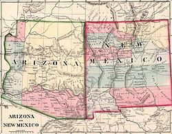
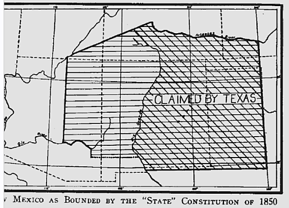
Capital Santa Fe Government Organized incorporated territory Governor - 1851-1852 James S. Calhoun - 1910-1912 William J. Mills Legislature New Mexico Territorial Legislature History - Treaty of Guadalupe Hidalgo May 30, 1848 - Organic Act September 9, 1850 - Gadsden Purchase June 24, 1853 - Arizona Territory split off February 24, 1863 - Statehood January 6, 1912 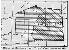 Proposed boundaries for State of New Mexico, 1850
The Territory of New Mexico was an organized incorporated territory of the United States that existed from September 9, 1850, until January 6, 1912, when the final extent of the territory was admitted to the Union as the State of New Mexico.
Contents
Statehood proposals
The Congressional Compromise of 1850 halted a bid for statehood under a proposed antislavery constitution.
The status of slavery during the territorial period provoked considerable debate. The granting of statehood was up to a Congress sharply divided on the slavery issue. Some (including Stephen A. Douglas) maintained that the territory could not restrict slavery, as under the earlier Missouri Compromise, while others (including Abraham Lincoln) insisted that older Mexican legal traditions, which forbade slavery, took precedence. Regardless of its official status, slavery was rare in antebellum New Mexico. Black slaves never numbered more than about a dozen.[1]
As one of the final attempts at compromise to avoid the Civil War, House Republicans offered to admit New Mexico as a slave state immediately. Although approved by committee on December 29, 1860, the South did not take up this offer.[clarification needed] [2] On February 24, 1863, during the American Civil War, Congress divided the territory and created the new Arizona Territory along current boundaries between the states. The act of establishment abolished slavery in the Arizona Territory.
Territorial evolution
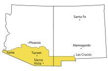 Gadsden Purchase 1853[3]
 New Mexico Territory 1866
Mexico ceded the region to the U.S. in the Treaty of Guadalupe Hidalgo in 1848 after the Mexican-American War. The area of the Gadsden Purchase was bought by the US in 1853. This added today's southern Arizona and a smaller area in today's southwestern New Mexico.[4] Texas claimed (but never controlled) the area from the Rio Grande to the present New Mexico-Texas border, bisecting historic New Mexico and slightly over half of today's New Mexico, until ceding it as part of the Compromise of 1850. This awarded Texas El Paso and the Texas Panhandle, which had been parts of the Spanish and Mexican territories of Santa Fe de Nuevo México.
The original 1850 New Mexico Territory included most of future Arizona (known as Santa Ana County), a small part of Colorado, and Nevada south of 36°30'N.[5] The establishment of Colorado Territory on February 28, 1861 and of Arizona Territory on February 24, 1863 (west of the 109th meridian) left New Mexico with its present boundaries.[6]
Civil War
Main article: New Mexico Territory in the American Civil WarAs the route to California, New Mexico and Arizona were disputed territory during the American Civil War, resulting in Gadsen settlers willingly joining the Confederate States of America. The Battle of Glorieta Pass gave the area primarily to the Union. Confederate Arizona Territory was the first American incarnation of Arizona.[7]
See also
- Adams-Onís Treaty, 1819
- American Civil War, 1861–1865
- Compromise of 1850
- Gadsden Purchase, 1853
- Governors of the Territory of New Mexico
- History of New Mexico
- Mexican-American War, 1846–1848
- Territorial evolution of the United States
- Territories of Spain that encompassed land that would later become part of the Territory of New Mexico:
- Nueva Vizcaya, 1562–1821
- Santa Fé de Nuevo Méjico, 1598–1821
- Tejas, 1690–1821
- Sonora y Sinaloa, 1732–1821
- Luisiana, 1764–1803
- Territory of France that encompassed land that would later become part of the Territory of New Mexico:
- Louisiane, 1682–1764 and 1803
- States and territory of Mexico that encompassed land that would later become part of the Territory of New Mexico:
- Santa Fé de Nuevo México, 1824–1848
- Coahuila y Tejas, 1824–1836
- Sonora y Sinaloa (Estado de Occidente), 1824–1830
- Sonora, 1830
- Territorial claim of the Republic of Texas, 1836–1845
- U.S. territories that encompassed land that would later become part of the Territory of New Mexico:
- Louisiana Purchase, 1803–1804
- District of Louisiana, 1804–1805
- Territory of Louisiana, 1805–1812
- Territory of Missouri, 1812–1821
- Former territorial claim of the Republic of Texas, 1845–1850
- U.S. military government of New Mexico, 1846
- U.S. provisional government of New Mexico, 1846–1850
- Mexican Cession, 1848
- State of Deseret, 1849-1850 (extralegal)
- U.S. territories that encompassed land that had previously been part of the Territory of New Mexico:
- Territory of Colorado, 1861–1876
- Territory of Arizona, 1863–1912
- U.S. states that encompass land that had once been part of the Territory of New Mexico:
- State of Nevada, 1864
- State of Colorado, 1876
- State of New Mexico, 1912
- State of Arizona, 1912
- Territories of Spain that encompassed land that would later become part of the Territory of New Mexico:
- Treaty of Guadalupe Hidalgo, 1848
References
- ^ http://www.blackpast.org/?q=aaw/new-mexico-territory-slave-code-1859-1867
- ^ David M. Potter (1976). The Impending Crisis. Harper & Row. pp. 533–534. ISBN 9780061319297. http://books.google.com/books?id=plCTI4F_-HYC.
- ^ William L. Marcy. "The Avalon Project: Gadsden Purchase Treaty: December 30, 1853". Yale University. http://www.yale.edu/lawweb/avalon/diplomacy/mexico/mx1853.htm. Retrieved 2008-10-10. The Purchase treaty defines the new border as "up the middle of that river (the Rio Grande) to the point where the parallel of 31° 47' north latitude crosses the same 31°47′0″N 106°31′41.5″W / 31.783333°N 106.528194°W; thence due west one hundred miles; thence south to the parallel of 31° 20' north latitude; thence along the said parallel of 31° 20' to the 111th meridian of longitude west of Greenwich 31°20′N 111°0′W / 31.333°N 111°W; thence in a straight line to a point on the Colorado River twenty English miles below the junction of the Gila and Colorado rivers; thence up the middle of the said river Colorado until it intersects the present line between the United States and Mexico." The new border included a few miles of the Colorado River at the western end; the remaining land portion consisted of line segments between points, including 32°29′38″N 114°48′47″W / 32.49399°N 114.813043°W at the Colorado River, west of Nogales at 31°19′56″N 111°04′27″W / 31.33214°N 111.07423°W, near AZ-NM-Mexico tripoint at 31°19′56″N 109°03′02″W / 31.332099°N 109.05047°W, the eastern corners of NM southern bootheel (Hidalgo County) at 31°47′02″N 108°12′31″W / 31.78378°N 108.20854°W, and the west bank of Rio Grande at31°47′02″N 106°31′43″W / 31.78377°N 106.52864°W
- ^ Department of State - Gadsden Purchase
- ^ Texas Handbook Online - Compromise of 1850
- ^ New York Times - The New Territory of Arizona
- ^ National Park Service - The Battle of Glorieta
External links
 State of New Mexico
Topics Delegations · Geography · Government · History · Landmarks · Military · Natural history · New Mexicans · Settlements · Transportation · Tribes · Visitor attractions
Society Culture · Demographics · Economy · Education · Politics
Regions Cities Alamogordo · Albuquerque · Artesia · Carlsbad · Clovis · Corrales · Deming · Española · Farmington · Gallup · Grants · Hobbs · Las Cruces · Las Vegas · Los Alamos · Los Lunas · Lovington · Portales · Raton · Rio Rancho · Roswell · Ruidoso · Santa Fe · Silver City · Socorro · Sunland Park · Taos · Tucumcari
Counties Bernalillo · Catron · Chaves · Cibola · Colfax · Curry · De Baca · Doña Ana · Eddy · Grant · Guadalupe · Harding · Hidalgo · Lea · Lincoln · Los Alamos · Luna · McKinley · Mora · Otero · Quay · Rio Arriba · Roosevelt · Sandoval · San Juan · San Miguel · Santa Fe · Sierra · Socorro · Taos · Torrance · Union · Valencia
Categories:- States and territories established in 1850
- States and territories disestablished in 1912
- New Mexico Territory


Wikimedia Foundation. 2010.