Jánoshalma — Jánoshalma … Deutsch Wikipedia
Jánoshalma — Héraldique … Wikipédia en Français
Janošhalma — Sp Jãnošhalma Ap Jánoshalma L Vengrija … Pasaulio vietovardžiai. Internetinė duomenų bazė
Jánoshalma — Sp Jãnošhalma Ap Jánoshalma L Vengrija … Pasaulio vietovardžiai. Internetinė duomenų bazė
Janoshalma — Original name in latin Jnoshalma Name in other language Janoshalma, Jnoshalma State code HU Continent/City Europe/Budapest longitude 46.29861 latitude 19.32583 altitude 136 Population 9755 Date 2012 01 18 … Cities with a population over 1000 database
Kleingebiet Janoshalma — Koordinaten fehlen! Hilf mit. Das Kleingebiet Jánoshalma (ungarisch Jánoshalmi kistérség) ist eine ungarische Verwaltungseinheit (LAU 1) innerhalb des Komitats Bács Kiskun. Der Verwaltungssitz ist in Jánoshalma. Gemeinden Borota Jánoshalma… … Deutsch Wikipedia
Kleingebiet Jánoshalma — Das Kleingebiet Jánoshalma (ungarisch Jánoshalmi kistérség) ist eine ungarische Verwaltungseinheit (LAU 1) innerhalb des Komitats Bács Kiskun. Der Verwaltungssitz ist in Jánoshalma. Gemeinden Borota Jánoshalma Kéleshalom Mélykút 46.28333333333319 … Deutsch Wikipedia
Bačka — (Serbian: Бачка or Bačka , Hungarian: Bácska , Croatian: Bačka , Slovak: Báčka , Rusyn: Бачка, Bunjevac: Bačka ) is an area of the Pannonian plain lying between the rivers Danube and Tisa. It is divided between Serbia and Hungary, with small… … Wikipedia
Bacs — Koordinaten fehlen! Hilf mit. Bács Kiskun Bács Kiskun Komitatssitz … Deutsch Wikipedia
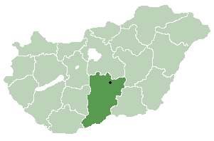
Bacs-Kiskun — Koordinaten fehlen! Hilf mit. Bács Kiskun Bács Kiskun Komitatssitz … Deutsch Wikipedia
 thumb|right|300px|Location_of_