- Class A airfield
-
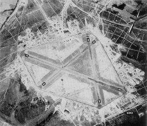
 An aerial view of RAF Exeter airfield on 20 May 1944, showing the triangular layout of the runways and the encircling (light-coloured) perimeter track
Class A airfields were military installations originally built for the Royal Air Force in the Second World War. Several were transferred to the U.S. Eighth Air Force for use as heavy bomber bases.
Class A layouts were constructed to specifications set by the British Air Ministry in August 1942, the main feature of which was a set of converging strips, each containing a concrete runway for takeoffs and landings, optimally placed at 60 degree angles to each other in a triangular pattern. The longest strip was designated the main strip and aligned southwest to northeast wherever possible, this being chosen to allow aircraft to takeoff and land into the prevailing winds. The other two runways were to allow use when the winds were blowing from other directions. The primary consideration was for operational safety for any type of aircraft then in operation or under development, including the U.S. B-29 Superfortress.
The strips were 600 feet (183 m) in width, cleared, graded and surfaced with turf. A concrete runway 150 feet (46 m) in width was centered on the strip, with a minimum length of 6,000 feet (1,830 m) for the main strip and 4,200 feet (1,280 m) for the secondary strips. On each side of the strip the field was cleared of obstructions and leveled an additional 300 feet (90 m). Gradients for the strips were a maximum 1 in 80 longitudinally and 1 in 60 transversely. In addition, an area at the end of each runway was cleared of obstructions at an angle of fifteen degrees outward from each side on a rising imaginary plane of 1 in 50 to provide a flightway called a funnel.
The material needs for building runways suitable for heavy bombers were approximately 18,000 tons of dry cement and 90,000 tons of aggregate. Expected stress factors of 2,000 pounds per square inch led to runway thicknesses of six to nine inches of concrete slab laid on a hardcore base, covered with a layer of asphalt. In areas where there was no natural rock, such as East Anglia, stone had to be imported for the hardcore.
 The runways at RAF Beaulieu
The runways were connected by taxiways called a perimeter track, of a standard width of 50 feet (15m). A 30-foot (9m) area was cleared and leveled on either side of the perimeter track. Class A specifications for taxiways set a minimum curve radius of 150 feet measured from the center line for angles greater than 60 degrees and 200 feet (61m) for angles less than 60 degrees. Perimeter track gradients could not exceed 1 in 40 in any direction, and no building could be placed closer than 150 feet from the edge of the track.
Dispersals called hardstands were placed along the perimeter track, made of concrete, with their centers at least 150 feet from the edge of the track and the edges of each hardstand separated from each other and from the funnels by a minimum of 150 feet. The purpose of the hardstands was to allow the parking of aircraft some distance from each other so that an air attack on the airfield would be less likely to destroy all the aircraft at once. Dispersal also minimised the chance of collateral damage to other aircraft should an accident occur whilst bombing-up.
Nine bases (Alconbury, Bassingbourn, Chelveston, Grafton Underwood, Kimbolton, Molesworth, Podington, Polebrook, and Thurleigh) were allotted to the Eighth Air Force but had been completed prior to the Class A standard for runway lengths. These were brought to Class A standards in 1942 and early 1943 by extending their runways, repositioning their perimeter tracks, and adding additional hardstands.
Class A airfields were also characterized by standardized technical site requirements for repair, maintenance and storage of aircraft. Two T2 type metal hangars (240 feet long by 115 feet wide by 29 feet high) were the standard for most bases, although a few pre-1942 bases had three T2 hangars and Thurleigh had four. Three bases (Chelveston, Molesworth, and Polebrook) also had a J Type brick-and-metal hangar (300' X 151') in addition to a pair of T2's, and Bassingbourn, which had been a pre-war RAF bomber station, had four C type brick hangars measuring 300 by 152 feet.
With the end of World War II and the resurgence of the sport of motor racing several former airfields were used as race tracks, e.g., Silverstone, Castle Combe, Goodwood Circuit, the races generally being run on the encircling perimeter track, one exception to this being the drag racing strip at Santa Pod Raceway, where the contestants use the runway of the former RAF Podington as a track.
See also
References
- Freeman, Roger A. (1991). The Mighty Eighth War Manual. ISBN 0-87938-513-8.
Categories:- World War II strategic bombing
- Aerial warfare strategy
- Royal Air Force stations


Wikimedia Foundation. 2010.