- Kinderdijk
-
Coordinates: 51°53′N 4°38′E / 51.883°N 4.633°E
Mill Network at Kinderdijk-Elshout * UNESCO World Heritage Site
View of windmills at KinderdijkCountry Netherlands Type Cultural Criteria i, ii, iv Reference 818 Region ** Europe and North America Coordinates 51°52′57″N 4°38′58″E / 51.8825°N 4.64944°E Inscription history Inscription 1997 (21st Session) * Name as inscribed on World Heritage List
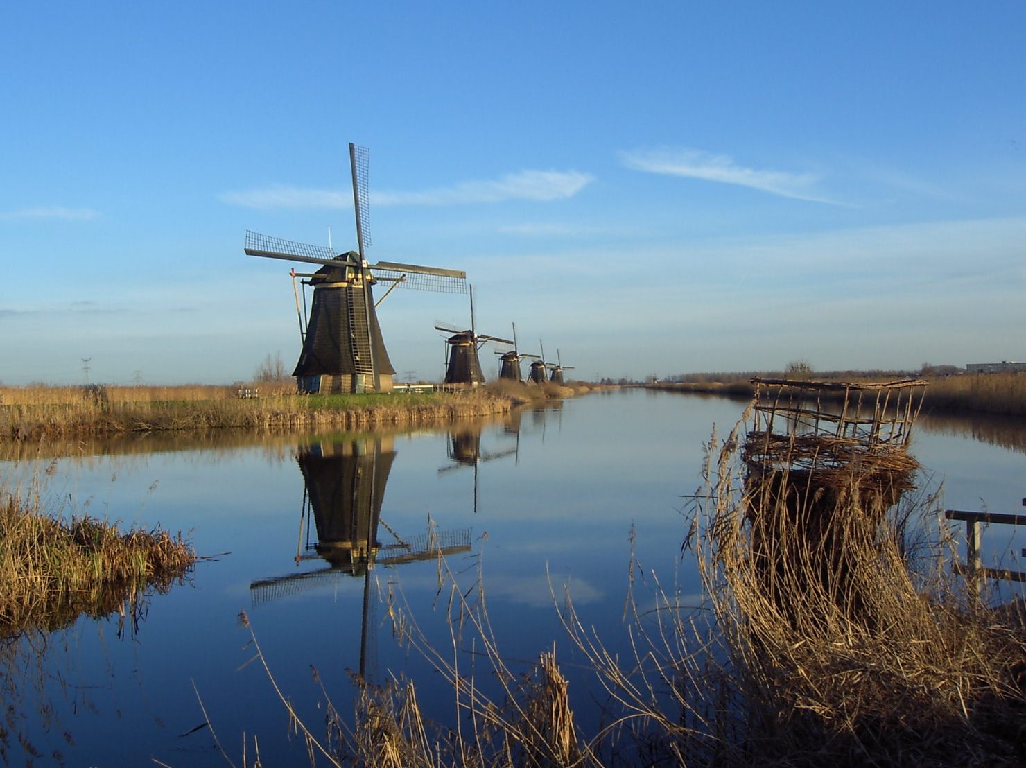
** Region as classified by UNESCOKinderdijk is a village in the Netherlands, belonging to the municipality of Nieuw-Lekkerland, in the province South Holland, about 15 km east of Rotterdam. Kinderdijk is situated in a polder at the confluence of the Lek and Noord rivers. To drain the polder, a system of 19 windmills was built around 1740. This group of mills is the largest concentration of old windmills in the Netherlands. The windmills of Kinderdijk are one of the best known Dutch tourist sites. They have been a UNESCO World Heritage Site since 1997.
Contents
Name
The name Kinderdijk is Dutch for "Children's dike". In 1421 during the Saint Elizabeth flood of 1421, the Grote Hollandse Waard flooded, but the Alblasserwaard polder stayed unflooded. It is said that when the terrible storm had subsided, someone went on to the dike between these two areas, to see what could be saved. He saw in the distance a wooden cradle floating. There was no hope that anything would be living in it, but when it approached, movement was seen. When the cradle came nearer, someone saw that a cat was in the cradle trying to keep it in balance by jumping back and forth so that no water could come into it. When the cradle eventually came near the dike, someone fished the cradle out and saw that in it a baby slept quiet and dry. In some of the stories the cat kept it balanced and afloat. This folktale and legend has been published as "The Cat and the Cradle" in English.[1]
History
In Alblasserwaard, problems with water became more and more apparent in the 13th century. Large canals, called "weteringen", were dug to get rid of the excess water in the polders. However, the drained soil started setting, while the level of the river rose due to the river's sand deposits. After a few centuries, an additional way to keep the polders dry was required. It was decided to build a series of windmills, with a limited capacity to bridge water level differences, but just able to pump water into a reservoir at an intermediate level between the soil in the polder and the river; the reservoir could be pumped out into the river by other windmills whenever the river level was low enough; the river level has both seasonal and tidal variations. Although some of the windmills are still used, the main water works are provided by two diesel pumping stations near one of the entrances of the windmills site.
See also
- Zaanse Schans, a similar site in which a historical view of the Dutch is shown.
References
- ^ Meder 2007; Griffis, 1918.
Sources
- Griffis, William Elliot. The Cat and the Cradle in Dutch Fairy Tales For Young Folks. New York: Thomas Y. Crowell Co., 1918. (English). Available online by SurLaLane Fairy Tales. File retrieved 9-12-2007.
- Meder, Theo. Dutch folk narrative. Meertens Instituut, Amsterdam. File retrieved 9-12-2007.
- World Heritage List: Mill Network at Kinderdijk-Elshout
External links
- Kinderdijk Foundation
- kinderdijk.nl
- Pictures of Kinderdijk
- Spherical Panorama of Kinderdijk at Sunset
- Photos from Kinderdijk 2011 October
World Heritage Sites in the Netherlands North 
East West Beemster Polder · Canals of Amsterdam · Defence Line of Amsterdam · Mill Network at Kinderdijk-Elshout · Rietveld Schröder House · Wadden Sea1
Curaçao 1 Shared locally with other region/s and with GermanyWindmills in the Netherlands Drenthe Aalden · Barger-Compascuum · Coevorden · Dalen (De Bente · Jan Pol) · De Groeve · De Wijk · Diever · Emmer-Compascuum · Erica · Gasselternijveen · Gieten · Gieterveen · Grolloo · Havelte · Hoogeveen · Makkum · Meppel (De Weert · De Vlijt) · Nijeveen (De Sterrenberg · Lutke's Meule · Tjasker) Noord-Sleen · Norg (De Hoop · Noordenveld) · Oudemolen · Peize · Roderwolde · Rolde · Ruinen · Schoonoord · Sleen · Veenoord · Vledder · Wachtum · Weerdinge · Zeijen (Meesterveen · Bollenveen) · Zuidbarge · Zuidlaren · Zuidwolde
Friesland Achlum · Akkrum · Aldeboarn · Aldtsjerk · Allingawier · Anjum · Augustusga · Bolsward (Tjasker · De Klaver · Lonjé Molen) · Broeksterwoude (De Broekmolen · De Grote Molen) · Buitenpost · Burdaard (De Olifant · De Zwaluw) · Burgwerd (Aylvapoldermolen · De Hiemerter Mole) · Burum · Cornwerd · De Blesse · De Hoeve · Dokkum (De Hoop · Zeldenrust · De Marmeerin) · Dronrijp (De Poelen · Kingmatille · De Hatsumermolen) · Earnewâld · Easterein · Easterlittens · Elsloo · Ezumazijl · Finkum · Formerum · Franeker · Goëngahuizen (De Jansmolen) · De Modderige Bol · Heechheim · Goutum (Kramersmolen · Molen Hoogland) · Grou (De Bird · De Borgmolen · De Haensmolen · Tjasker) · Hallum · Hantum · Hartwerd · Heerenveen · Hogebeintum · Hollum · Holwerd (De Hoop · Miedenmolen) · Húns · Iens · IJlst · Jislum · Joure (De Groene Molen · Penninga's Molen) · Kimswerd · Kollum · Kollumerpomp · Koudum · Langweer · Leeuwarden (Froskepôlemolen, Cammingha-Buurstermolen) · Lekkum · Lollum · Makkinga · Marrum (De Grote Molen · De Kleilânsmole · De Phenix) · Marssum (De Marssumermolen · Terpzigt) · Menaldum (De Kievit · De Rentmeester) · Metslawier · Mildam · Munnekezijl · Nes · Nij Beets · Nijemirdum · Nijetrijne (De Reiger · De Rietvink · Boktjasker) · Nijhuizum · Noordwolde · Oppenhuizen · Oude Leije · Oudega · Paesens · Rinsumageest · Roodkerk · Ryptsjerk · Schalsum · Scharsterberg · Sexbierum · Sleat · Sneek · Johannesga · Stiens (De Hoop · De Kleine Molen · De Stienhuistermolen) · Sumar · Surhuisterveen · Tijnje · Tjerkwerd · Tytsjerk (De Himriksmole · De Lytse Geast) · Tzum (Teetlum · Fatum) · Veenwouden · Vegelingsoord · Vrouwenparochie · Wanswerd · Watena · Wergea (De Hempenserpoldermolen · Paaltjasker) · Westergeest · Wijckel · Winsum · Witmarsum · Wolvega (De Gooyer · Windlust) · Workum (De Nijlânnermolen · Ybema's Molen · Het Heidenschap · De Snip) · Woudsend ('t Lam · De Jager) · Wyns.
Gelderland Aalten · Afferden · Alphen aan de Maas · Alverna · Arnhem (smock mill built in 1960 · post mill built in 1925 · Boktjasker · post mill built in 1946 · De Kroon · Het Fortuyn · Mijn Genoegen · Vorheen · post mill built in 1989 · De Hoop) · Batenburg · Beesd · Beneden-Leeuwen · Bergharen · Beuiningen · Braamt · Breedevoort · Breedenbroek · Bronkhorst · Buren · Culemborg (De Hoop · Johanna) De Heurne · Deil · Dichteren · Didam · Doetinchem (Benninkmolen · De Walmolen) · Ede (De Keetmolen · Concordia) · Ede-Doesburgerbuurt · Elden · Elspeet · Etten · Garderen · Geesteren · Geldermalsen (smock mill · De Bouwing) · Giesbeek · Gorssel · Groesbeek · Haaften · Harderwijk · Harreveld · Harskamp · Hattem · Hellouw (Achterse Molen · 't Veertje · Hooglandse Molen) · Hernen · Herveld · Hurmen · Hulshorst · Hurwenen · Ingen · Kekerdom · Kerkdriel · Kesteren · Klarenbeek · Laag-Keppel · Lienden (De Marsch · De Zwaan) · Linde · Lintelo · Lobith · Loechem-Zwiep · Loil · Lunteren · Maurik · Meddo · Miste · Nederasselt · Nederhemert · Neede · Nieuw-Wehl · Nijkerk-Appel · Nijmegen (Sint Annamolen · Witte Molen) · Nunspeet · Oene · Oldebroek · Oostendorp · Oud-Zevenaar · Overasselt · Putten · Rekken · Rha · Rijswijk · Ruurlo · Silvolde · Stokkum · Terschuur · Terwolde · Twello · Vaassen · Valburg · Varik · Varsseveld · Veessen · Voorst · Vorden (De Hoop · Hackforter Mölen) · Vragender · Waardenbrug (mill built in 1867 · C18th mill) · Wadenoijen · Wageningen · Walderveen · Wapenveld (De Vlijt · De Wielwaal) · Warken · Warnsveld · Wenum · Wijchen · Wilp-Posterenk · Winsen · Winterswijk (Venemansmolen · De Bataaf) · Zeddam (De Volharding · Grafelijke Korenmolen) · Zelhem-Wittebrink · Zevenaar · Zoelen · Zuilichem (smock mill · De Hoop)
Groningen Adorp · Aduard · Bellingwolde · Bourtange · Delfzijl · Den Andel · Den Ham · Eemshaven · Eenrum · Enumatil · Farmsum · Feerwerd · Ganzedijk · Garmerwolde · Garnwerd · Garsthuizen · Glimmen · Grijpskerk (De Kievit · Westerhornermolen) · Haren · Haren-Hoornsedijk · Harkstede · Heiligerglee · Hoeksmeer · Kantens · Kolham · Kropswolde · Laskwerd · Leegkerk · Loppersum · Mensingeweer · Middelstum · Neibert · Nieuw-Scheemda (De Dellen · Westerse Molen) · Nieuwe-Pekela · Niezijl · Noordbroek · Noordbroeksterhamrik · Norddijk · Noorderhoogebrug · Noordhorn · Noordlaren · Oldehove (Aeolus · De Leeuw) · Onderdendam · Onnen · Oude-Pekela · Overschild · Peiterburen · Sebaldeburen · Slochteren (Groote Polder Molen · De Ruiten · Fraeylemamolen) · Spijk · Ten Boer (Bovenrijge · De Widde Meuln) · Ten Post · Ter Haar · Thesinge · Uithuizen · Usquert · Veelerveen · Vierhuizen · Vierverlaten · Visvliet · Vriescheloo · Wedderbergen · Wedderveer · Westerwijtwerd (De Palen · Zeldenrust) · Wetsinge · Winschoten (Molen Dijkstra · Molen Edens) · Winsum (De Ster · De Vriendschap) · Woltersum · Zandeweer · Zeerijp · Zuidwolde ('t Witte Lam · Krimstermolen · Koningslaagte) · Zuurdijk
Limburg Afferden · Baexem · Beegden · Beek · Beesel · Bemelen-Wolfshuis · Gennep · Heijen-Diekendaal · Heythuysen-Areven · Horn (De Hoop · De Welvaart) · Kessel · Maasbracht · Maastricht · Melick · Merselo · Meterik · Nederweert-Kreijel · Nederweert-Roeven · Nuth · Oirsbeek · Ospel · Ottersum · Roggel · Sint Odiliënburg · Stevensweert · Stramproy (Molen van Nijs · Sint Jan) · Swartbroek · Ubachsberg · Urmond · Venray · Sint Oda · Weert-Hushoven · Weert-Keent · Weert-Laar · Weert-Tungelroy
North Brabant Aalst · Almkerk (Oude Doornse Molen · Zandwijkse Molen) · Asten · Bakel · Bavel · Bergeijk · Beugen · Boekel · Borkel · Budel (Janzona · Nooit Gedacht · Zeldenrust) · Den Dungen-Maaskantje · Den Hout · Deurne (Holten's Molen · Maria-Antoinette) · Dieden · Dongen · Drunen · Dussen · Eindhoven-Acht · Etten-Leur · Gassel · Geffen (De Vlijt · Zeldenrust) · Geldrop · Gemert · Goirle (De Visscher · De Wilde) · Halsteren · Hank · Hapert · Haps · Heensche Molen · Heeze · Heusden (Nummer I · Nummer II · Nummer III) · Hilvarenbeek · Hoeven · Hooge Zwaluwe · Huijbergen · Kaatsheuvel (De Couwenbergh · De Eendragt) · Katwijk-Linden · Leur (De Lelie · Zwartenbergse Molen) · Lieshout (De Leest · Vogelenzang) · Liessel · Lith · Luyksgestel · Made · Meerveldhoven · Meeuwen · Megen · Mierlo · Mierlo-Ellenaar · Milheeze · Mill · Moergestel · Nieuw-Borgvliet · Nieuw-Vossemeer · Nieuwkuijk · Nispen · Nistelrode · Nuenen · Oeffelt · Oirschot · Oisterwijk · Oploo · Oss (Nieuwe Leven · Zeldenrust) · Oudemolen · Raamsdonksveer · Ravenstein · Reek · Rijkevoort · Roosendaal (De Hoop · De Twee Gebroeders) · Rosmalen · Rucpen-Bosschenhoofd · Schaijk · Schijndel (Aan de Pegstukken · Catharina) · Sint Agatha · Sint Hubert · Sint Michielsgestel · Sleeuwijk · Someren (De Victor · Den Eveert) · Sprang · Sprundel · Terheijden · Udel · Ulvenhout · Veen · Veldhoven · Veldhoven-Zeelst · Vessem · Vlierden · Volkel · Vorstenbosch · Wanroij · Werkendam · Wijk en Aalburg · Willemsted · Woudrichem · Wouw · Zeeland (Aarssensemolen · Coppensmolen) · Zeeland-Oventje · Zevenburgen · Zundert
North Holland Aalsmeer (De Leeuw · Stommeermolen · De Zwarte Ruiter) · Aartswoud · Akersloot (De Oude Knegt · Noordermolen) · Alkmaar (De Piet · De Eendracht · De Viaan · Geestmolen · Robonsbosmolen) · Alkmaar-Koedikl · Amstelveen · Amsterdam (De Bloem · De Gooiyer · De Otter) · Amsterdam-Buiksloot · Amsterdam-Biekenveldert · Amsterdam-Sloten · Amsterdam Slotermeer (De 1100 Roe · De 1200 Roe) · Amsterdam Zuid-Oost · Ankeveen · Anna Paulowna · Bergen (Damlandermolen · Philisteinse Molen) · Bovenkarspel · Broek op Langdedijk · Burgerbrug (Molen F · Molen Zuider-G) · Burgervlotbrug · Callantsoog · De Waal · Den Oever · Driemond · Edam · Egmond aan den Hoef (Bosmolen · Wimmenumer Molen) · Enkhuizen · Etersheim · Groenveld · Groet-Schoorl · Grootschermer (De Havik · Menningweermolen · post mill) · Haarlem (Schoterveense Molen · De Adriaan) · Haarlem-Penningsveer (De Veer · De Kleine Veer) · Haarlem-Schalkwijk (De Eenhorn · De Kleine Molen) · Haarlem-Vijfhuizen · Heemstede · Heerhugowaard · Heiloo · Hensbroek · Hippolytushoef · Hofddorp · Hoogwoud (De Lastdrager · De Vier Winden) · Katwoude · Koog aan de Zaan · Kortenhoef · Krommeniedijk · Landsmeer · Laren · Medemblik · Middenbeemster · Muiderberg · Neck · Nederhorst den Berg · Nieuwe Niedorp · Obdam (Berkmeermolen · Obdammermolen · Weel & Braken) · Oosterblokker · Oosterend · Oostwoud · Oostzaan · Oterleek · Oude Niedorp · Ouderkerk aan de Amstel · Oudeschild · Oudorp ('t Roode Hert · Strijkmolen B · Strijkmolen C · Strijkmolen D Strijkmolen E Ambachtsmolen) · Rustenburg (Strijkmolen I · Strijkmolen K Strijkmolen L) · Santpoort · Schagerbrug (Molen D · Molen O-D) · Schellinkhout (De Grote Molen · Johan) · Schermerhorn (Bovenmolen E · Bovenmolen G · Ondermolen C · Ondermolen D · Ondermolen K Poldermolen O) · Schoorl (Hagermolen · Kijkduin) · Schoorldam · Sint Maartensvlotbrug (Molen N-G · Molen N-M) · Sint Pancras · Spaarndam-Oost · Spanbroek (De Kaagmolen · De Westerveer) · Stompetoren (Poldermolen D · Poldermolen E · Poldermolen M) · Tuitjenhorn · 't Zand (Molen O-T · Molen P-V) · Uitgeest (Tweede Broekermolen · De Dog · De Dorregeester · De Kat · De Jonge Leeuw) · Ursem · Waarland (Poldermolen · Slootgaardmolen) · Weesp ('t Haantje · De Eendragt · De Vriendschap) · Wervershoof · Westzaan (De Zwaan · De Jonge Dirk · De Schoolmeester · Het Prinsenhof) · Wieringerwaard · Wijdenes · Wogmeer · Wognum · Wormer · Zaandam (Zaanse Schans - De Bonte Hen · De Gekroonde Poelenburg · De Hadel · Het Jonge Schaap · De Huisman · De Kat De Zoeker · Het Klaverblad · De Os) · De Held Jozua · De Ooievaar · Kaatmolen · De Windhond · De Zwarte Kalf · De Kroosduiker) · Zaandijk · Zuidschermer (Paaltjasker · Poldermolen K)
Overijssel Almelo · Ane · Balkbrug · Dalfsen · Denekamp (Nieuwe Molen · Borgelinkmolen) · Deventer · Fleringen · Geesteren · Giethoorn (Noord · Zuid) · Goor · Haaksbergen · Hardenberg · Hasselt · Hellendoorn (De Hoop · De Wippe) · Holten-Dijkerhoek · Kampen · Lattrop · Lettele · Lonneker · Markelo · Marle · Olst · Ommen (De Besthmenermolen · De Konijnenbelt · De Lelie · Den Oordt) · Ootmarsum · Ossenzijl , Radewijk · Reutum · Rijssen · Saasveld · Sint Jansklooster (De Foeke · Monnikenmolen) · Slagharen · Staphorst · Tilligte · Usselo · Vilsteren · Vriezenveen · Welsum · Wijhe · Windesheim · Zalk · Zwolle
Utrecht Abcoude (De Broekzijde Molen · Oostzijdse Molen) · Baambrugge · Breukelen · Bunschoten · Cabauw · Cothen · Elst · Groenekan · IJsselstein · Kockengen (Kockengense Molen · Spengense Molen) · Loenen aan de Vecht (De Hoop · Loenderveense Molen) · Montfoort · Nieuwegein · Nieuwersluis · Nigteviecht · Oud-Zuilen (Buitenwegse Molen · Westbroekse Molen) · Rhenen · Soest · Tienhoven · Utrecht (De Ster · Rijn en Zon) · Veenendaal (De Nieuwe Molen · De Vriendschap) · Vreeland (De Ruiter · Hoekermolen) · Werkhoven · Westbroek · Wijk bij Duurstede · Wilnis · Woerden
Zeeland Aagtekerke · Arnemuiden · Axel · Biervliet · Biggekerke · Borssele · Brouwershaven (De Haan · Windlust) · Burgh-Haamstede · Cadzand · Colijnsplaat (De Oude Molen · Nooit Gedacht) · Domburg · Dreischor · Eindewege · Elkerzee-Scharendijke · Ellemeet · Gapinge · Goes · Grijpskerke · Heinkenszand · Hoedekenskerke · Hoek · Hulst · IJzendijke · Kerkwerve-Moriaanshoofd · Kloetinge · Kloosterzande · Koudekerke · Krabbendijke · Kruiningen · Kuitaart · Meliskerke · Middelburg (De Hoop · De Koning · De Seismolen · Ons Genoegen) · Nieuw- en Sint Joosland · Nieuwerkerk · Nieuwvliet · Nisse · Oost-Souburg · Oosterland · Oostkapelle · Oud Vossemeer · Ovezande · Poortvliet · Retranchement · Rilland-Bath · Scherpenisse · Schoondijke · Serooskerke · 's-Gravenpolder · Sint Annaland (post mill · De Vier Winden) · Sint Maartensdijk · Sint Philipsland · Sluis · Spui · Stavenisse · Tholen · Veere · Vlissingen · Waarde · Wemeldinge (Aeolus · De Hoop ) · Westkapelle · Wissenkerke (De Onderneming · Landzigt) · Wolphaartsdijk · Zierikzee (De Hoop · Den Haas) · Zonnemaire · Zoutelande · Zuidzande
South Holland Aarlanderveen (De Morgenster · Molen Nummer 1 · Molen Nummer 2 · Molen Nummer 3 · Molen Nummer 4) · Abbenbroek · Achthuizen · Alblasserdam (Kortlandse Molen · De Blokweerse Molen) · Alphen aan den Rijn (De Eendracht · Vrouwgeestmolen) · Arkel · Barendrecht · Benthuizen · Bergambacht · Berkel en Rodenrijs · Bleskensgraaf (Tjasker · Hofwegensemolen · Wingerdse Molen) · Bodegraven · Brielle · Delft · Den Bommel · Den Haag (Laakmolen · Nieuwe Veenmolen) · Dirksland · Dordrecht · Geervliet · Giessendam · Goedereede · Gorinchem (De Hoop · Nooit Volmaakt · Oostmolen · Westmolen) · Gouda ('t Slot · De Roode LeeuwHaastrechtse Molen) · Goudriaan · Goudswaard · Groot Ammers (Achterlandse Molen · De Achtkante MolenDe Graaflandse Molen · Gelkense Molen · De Jonge Sofia) · Hazerswoude-Dorp (Gere Molen · Nieuw Leven · Rietveldse Molen · Rooie Wuip) · Hazerswoude-Rijndijk (Groenendijkse Molen · De Rijnenburger) · Hei- en Boeicop · Hellevoetsluis · Herkingen · Hoek van Holland · Hoogmade (Grosmolen · DoesmolenHoogmadese MolenVlietmolen) · Hoornaar (Oudendijkse Molen · Scheiwijkse Molen) · Kaag · Katwijk aan den Rijn · Kinderdijk (Nederwaard Molen Nummer 1 · Nederwaard Molen Nummer 2 · Nederwaard Molen Nummer 3 · Nederwaard Molen Nummer 4 · Nederwaard Molen Nummer 5 · Nederwaard Molen Nummer 6 · Nederwaard Molen Nummer 7 · Nederwaard Molen Nummer 8 · Overwaard Molen Nummer 1 · Overwaard Molen Nummer 2 · Overwaard Molen Nummer 3 · Overwaard Molen Nummer 4 · Overwaard Molen Nummer 5 · Overwaard Molen Nummer 6 · Overwaard Molen Nummer 7 · Overwaard Molen Nummer 8) · Koudekerke aan den Rijn (Hondsdikse Molen · Lagenwaardse Molen) · Krimpen aan den IJssel · Langerak · Leerdam · Leiden (De Heesterboom · De Herder · De Put · De Valk · Kikkermolen · Maredijkmolen · Rodenburgermolen · Stadsmolen) · Leiden-Stevenshof · Leiderdorp (Achthovense Molen · Kalkmolen · Doeshofmolen · Munnikermolen · Zijllaanmolen) · Leidschendam (De Salamander · Bovenmolen · Middenmolen · Ondermolen) · Lexmond · Lisse (Keukenhofmolen · Lageveensemolen · Lisserpoelmolen · Zemelmolen) · Loosduinen · Maasdam (De Hoop · Sint Anthonymolen) · Maasland (De Drie Lelies · Dijkmolen) · Maassluis (De Hoop · De Wippersmolen) · Meerkerk-Den Dool · Mijnsheerenland (De Goede Hoop · Oostmolen) · Moerkapelle · Molenaarsgraaf (De Kerkmolen · De Middelmolen) · Monster · Nieuw-Beijerland · Nieuw-Lekkerland · Nieuwe-Tonge · Nieuwenhoorn · Nieuwerbrug · Nieuwerkerk aan den IJssel · Noordeloos · Nordwijk · Noordwijkerhout · Nootdorp · Oegstgeest · Oostvoorne · Oud-Ade (Rode Molen · Vrouw Vennemolen · Akkersslootmolen) · Oud-Alblas (De Peilmolen · Kooijwijkse Molen) · Ouddorp (De Hoop · De Zwaan) · Oude-Tonge · Oukoop · Piershil · Puttershoek · Rijnsaterwoude (De Geestmolen · Dekkermolen) · Rijpwetering (Adermolen · Blauwe MolenBuurtermolen · Lijkermolen Nummer 1 · Lijkermolen Nummer 2 · Moppermolen · Waterloosmolen) · Rijsoord · Rijswijk · Rockanje · Roelofarendsveen (Googermolen · Veendermolen) · Rotterdam-Charlois · Rotterdam-Delfshaven · Rotterdam-Hillegersbeeg · Rotterdam-Kralingen (De Lelie · De Ster) · Rotterdam-Overschie · Rotterdam-Terbregge · Rozenburg · Schiedam (De Drie Korenblomen · De Nieuwe Palmboom · De Noord · De Vrijheid · De Walvisch · Noletmolen) · Schipluiden (De Korpershoek · Groeneveldse Molen) · 's-Gravendeel · 's-Gravenzande · Sommelsdijk · Spijkenisse · Stad aan 't Haringvliet · Stellendam · Streefkerk (Broekmolen · De Achtkante Molen · De Liefde · Klein Molen · Oude Weteringmolen) · Vlaardingen · Vlist (Bonrepasmolen · De Bachtenaar) · Vorburg · Voorhout · Voorschoten · Warmond (Boterhuismolen · Broekdijkmolen · De KokFaljermolen · Lakermolen · Nieuwe Hofmolen · Zwanburgermolen · Zweilandermolen · 't Poeltje) · Wassenaar (Windlust · Zuidwijksemolen) · Wateringen · Westmaas · Woerdense Verlaat · Zevenhuizen (Eendrachtsmolen · Tweemanspolder Nummer 1 · Tweemanspolder Nummer 2 · Tweemanspolder Nummer 3 · Tweemanspolder Nummer 4) · Zoetermeer · Zoetermeer-Dorp · Zoetermeer-Rijndijk (Barremolen · Grote Molen · Meerburgermolen) · Zuid-Beijerland · Zuidland · Zwamerdam (De Dikke Molen · Steektermolen)
Categories:- World Heritage Sites in the Netherlands
- Windmills in South Holland
- Populated places in South Holland
- Visitor attractions in South Holland
- Nieuw-Lekkerland
Wikimedia Foundation. 2010.