- East Hertfordshire
-
East Hertfordshire District — Non-metropolitan district — East Hertfordshire shown within Hertfordshire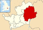
Sovereign state United Kingdom Constituent country England Region East of England Non-metropolitan county Hertfordshire Status Non-metropolitan district Admin HQ Bishop's Stortford, Hertford Incorporated 1 April 1974 Government – Type Non-metropolitan district council – Body East Herts Council – Leadership Leader & Cabinet (Conservative) – MPs Oliver Heald
Stephen McPartland
Mark PriskArea – Total 70.9 sq mi (183.7 km2) Area rank 95th (of 326) Population (2010 est.) – Total 138,500 – Rank 145th (of 326) – Density 1,952.7/sq mi (753.9/km2) – Ethnicity 94.7% White
1.8% S.Asian
1.2% Black
1.3% Mixed Race
1.1% Chinese or OtherTime zone GMT (UTC0) – Summer (DST) BST (UTC+1) ONS code 26UD OS grid reference TL3758624322 Website eastherts.gov.uk East Hertfordshire is a local government district in Hertfordshire, England. Its council has offices in Bishop's Stortford and Hertford (Hertfordshire's traditional county town).
The other main towns in the district are Ware (on the River Lea), Buntingford (on the River Rib), and Sawbridgeworth (on the River Stort). Of these five major towns, all except Buntingford fall within the parliamentary constituency of Hertford and Stortford. Buntingford is part of the North East Hertfordshire constituency.
East Herts, as its council is officially known, is bordered by North Hertfordshire, Stevenage, Welwyn Hatfield, and Broxbourne in Hertfordshire, and by Epping Forest, Harlow, and Uttlesford in Essex.
The district was formed on 1 April 1974, as a merger of the municipal borough of Hertford with Bishop's Stortford, Sawbridgeworth and Ware urban districts, and Braughing Rural District, Ware Rural District and part of Hertford Rural District. By area it is the largest of the ten local government districts in Hertfordshire.
In the 2006 edition of the Channel 4 "Best and Worst Places to Live in the UK", East Hertfordshire was rated the seventh best district to live in.
Contents
Transport
The district contains only one motorway - a small stretch of the M11 at Bishop's Stortford. The major roads within the district include:
A414 - running West-East from Welwyn to Harlow, through Hertford, where it forms the Hertford by-pass.
A10 - running North-South from Broxbourne towards Cambridge.
A602 - running South East to North West, connecting Ware with Stevenage.
A120 - running West-East connecting the A10 at Standon with the M11 at Bishop's Stortford.
None of the above roads are classified as trunk roads. Therefore they are maintained by Hertfordshire County Council while responsibility for the M11 rests with the Highways Agency.
Stansted Airport is just beyond the edge of the district near Bishop's Stortford, but officially sits within Uttlesford district in neighbouring Essex. Many of the district's towns have rail services into London at King's Cross, Moorgate, and Liverpool Street.
Employment
The district's biggest employer is the pharmaceutical company GlaxoSmithKline, which has a research and maufacturing centre in Ware.[1] The company also has large offices in neighbouring Stevenage and Harlow.
Parishes
The district is entirely parished. See List of civil parishes in Hertfordshire.
Footnotes
- ^ East Herts District Council, checked on 1 November 2009.
Ceremonial county of Hertfordshire Boroughs or districts Major settlements - Apsley
- Baldock
- Berkhamsted
- Bishop's Stortford
- Borehamwood
- Broxbourne
- Buntingford
- Bushey
- Cheshunt
- Harpenden
- Hatfield
- Hemel Hempstead
- Hertford
- Hitchin
- Hoddesdon
- Letchworth
- Potters Bar
- Radlett
- Rickmansworth
- Royston
- Sawbridgeworth
- St Albans
- Stevenage
- Tring
- Waltham Cross
- Ware
- Watford
- Welwyn Garden City
See also: List of civil parishes in Hertfordshire
Topics - Parliamentary constituencies
- Places
- SSSIs
- Visitor attractions
 Districts of the East of England
Essex Basildon • Braintree • Brentwood • Castle Point • Chelmsford • Colchester • Epping Forest • Harlow • Maldon • Rochford • Southend-on-Sea • Tendring • Thurrock • Uttlesford
Hertfordshire Broxbourne • Dacorum • East Hertfordshire • Hertsmere • North Hertfordshire • St Albans • Stevenage • Three Rivers • Watford • Welwyn Hatfield
Bedfordshire Cambridgeshire Norfolk Suffolk Categories:- East Hertfordshire
- Non-metropolitan districts of Hertfordshire
- Local government districts of the East of England
- Hertfordshire geography stubs


Wikimedia Foundation. 2010.