- Cynon Valley
-
Coordinates: 51°39′25″N 3°27′40″W / 51.657°N 3.461°W
Cwm Cynon
Cynon Valley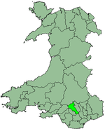
Geography Status District, Borough 1974 area 100,020 acres (404.8 km2)[1] HQ Aberdare (Welsh: Aberdâr) History Created 1974 Abolished 1996 Succeeded by Rhondda Cynon Taff Demography 1973 population 69,630[2] 1992 population 65,600[3] The Cynon Valley (Welsh: Cwm Cynon), is a famous former coal mining valley within the South Wales Valleys of Wales. The Cynon Valley lies between the other mining Valley of Rhondda and the iron industrial Valley of the Merthyr Valley. Its main towns are Aberdare (Welsh: Aberdâr) located North of the Valley and Mountain Ash (Welsh: Aberpennar) located in the South of the Valley. Also known as Snake or Scab Valley.
According to the 2001 Census, the Cynon Valley has a population of 63,512.[4] In 2001 12.1% of the inhabitants were recorded as Welsh speakers. In common with the other South Wales Valleys, the Cynon Valley had a high number of Welsh speakers until the early 20th century.
Contents
Former district
From 1974 to 1996 the Borough of Cynon Valley was one of thirty-seven districts of Wales, this borough was the Cynon Valley Borough Council (Welsh:Cyngor Bwrdeistref Cwm Cynon), this formed from the Aberdare and Mountain Ash urban districts, the parish of Rhigos from Neath Rural District and the parish of Penderyn from Brecknockshire.[1] It was one of six districts in the county of Mid Glamorgan, and in 1996 was merged into the larger unitary authority of Rhondda Cynon Taf.
Parliamentary and assembly constituency
In 1983 a parliamentary constituency of Cynon Valley was formed for the election of a member of parliament to the United Kingdom House of Commons. The constituency had identical boundaries to the local government district.[5][6] In 1999 a Welsh Assembly constituency with the same boundaries was formed. In 2010 the constituency was redefined as consisting of 15 electoral divisions of the county borough of Rhondda Cynon Taff: Aberaman North, Aberaman South, Abercynon, Aberdare East, Aberdare West/Llwydcoed, Cilfynydd, Cwmbach, Glyncoch, Hirwaun, Mountain Ash East, Mountain Ash West, Penrhiwceiber, Pen-y-waun, Rhigos, Ynysybwl.[7]
Education
College
Coleg Morgannwg has four campuses within Rhondda Cynon Taf, one in the Cynon Valley, one in the Rhondda Valley, and two in the Taf-Ely Valley. Coleg Morgannwg Aberdâr is the Cynon Valley campus which is situated in Cwmdâr near the town of Aberdare. Other campuses include Coleg Morgannwg Rhondda in Llwynapia in the Rhondda Valley, and Coleg Morgannwg Pontypridd and Coleg Morgannwg Nantgarw in the Taf-Ely Valley.
Comprehensive Schools
Within the Cynon Valley there are six Comprehensive Schools of which one is a Welsh-Medium School. These School are:
- Ysgol Gyfun Rhydywaun - Welsh-Medium School
- Ysgol Gyfun Aberpennar - Mountain Ash Comprehensive School - English-Medium School
- Ysgol Gyfun Blaengwawr - Blaengwawr Comprehensive School - English-Medium School
- Ysgol Aberdâr y Merched - Aberdare Girls School - English-Medium School
- Ysgol Uwchradd Aberdâr - Aberdare High School - English-Medium School
- Ysgol Uwchradd Ioan Fedyddiwr yr Eglwys yng Nghymru - St. John the Baptist High School Church in Wales - English-Medium School
Places within the Cynon Valley
The Cynon Valley consists of two towns which are Aberdare and Mountain Ash, Aberdare is the main town of the valley which had a population of around 31,619 in 1991.
Villages around the town of Aberdare
- Aberaman
- Aberdâr
- Abercwmboi
- Abernant
- Croesbychan
- Cwmaman
- Cwmbach
- Cwmdâr
- Gadlys
- Godreaman
- Hirwaun
- Llwydcoed
- Trecynon
- Penderyn
- Penywaun
- Rhigos
Villages around the Town of Mountain Ash
- Abercynon
- Mountain Ash/Aberpennar
- Bryntirion
- Caegarw
- Carntown
- Cefnpennar
- Cwmpennar
- Fernhill
- Maes y Ffynnon
- Miskin
- Nant-y-Fedw
- Newtown
- Penrhiwceiber
- Perthcelyn
- Pontcynon
- Tyntetown
- Ynysboeth
References
- ^ a b Local government in England and Wales: A Guide to the New System. London: HMSO. 1974. p. 60. ISBN 0117508470.
- ^ Registrar General's annual estimated figure mid 1973
- ^ OPCS Key Population and statistics 1992 cited in Whitaker's Concise Almanack 1995. London: J Whitaker & Sons. 1994. p. 566. ISBN 0850212472.
- ^ "2001 Census of Population. Key Statistics for Assembly Constituencies: Cynon Valley". Welsh Assembly. April 2003. http://www.assemblywales.org/03-030.pdf.
- ^ The Parliamentary Constituencies (Wales) Order 1983 (S.I. 1983/418)
- ^ "The Parliamentary Constituencies (Wales) Order 1995 (S.I. 1995/1036)". The National Archives. http://www.legislation.gov.uk/uksi/1995/1036/schedule/made.
- ^ "The Parliamentary Constituencies and Assembly Electoral Regions (Wales) Order 2006 (S.I. 2006/10341)". The National Archives. http://www.legislation.gov.uk/uksi/2006/1041/schedule/1/made.
External links
Clwyd Dyfed Gwent Gwynedd Mid Glamorgan Powys South Glamorgan West Glamorgan Lliw Valley • Neath • Port Talbot • Swansea
Categories:- Glamorgan
- Former subdivisions of Wales
- Valleys of Wales

Wikimedia Foundation. 2010.