Zushi, Kanagawa

Zushi, Kanagawa

Japanese city
Name=Zushi City
JapaneseName=逗子市
Prefecture=Kanagawa Prefecture
Region=Kantō
Area_km2=17.34
Population=58,597
PopDate=2003
Density_km2=3379.30
Coords =
Postal code=
Area code=
Mayor =
Tree =
Flower =
Bird =
Symbol

CityHallAddress=
CityHallPhone=
CityHallLink = [http://www.city.zushi.kanagawa.jp/ Zushi City] | City
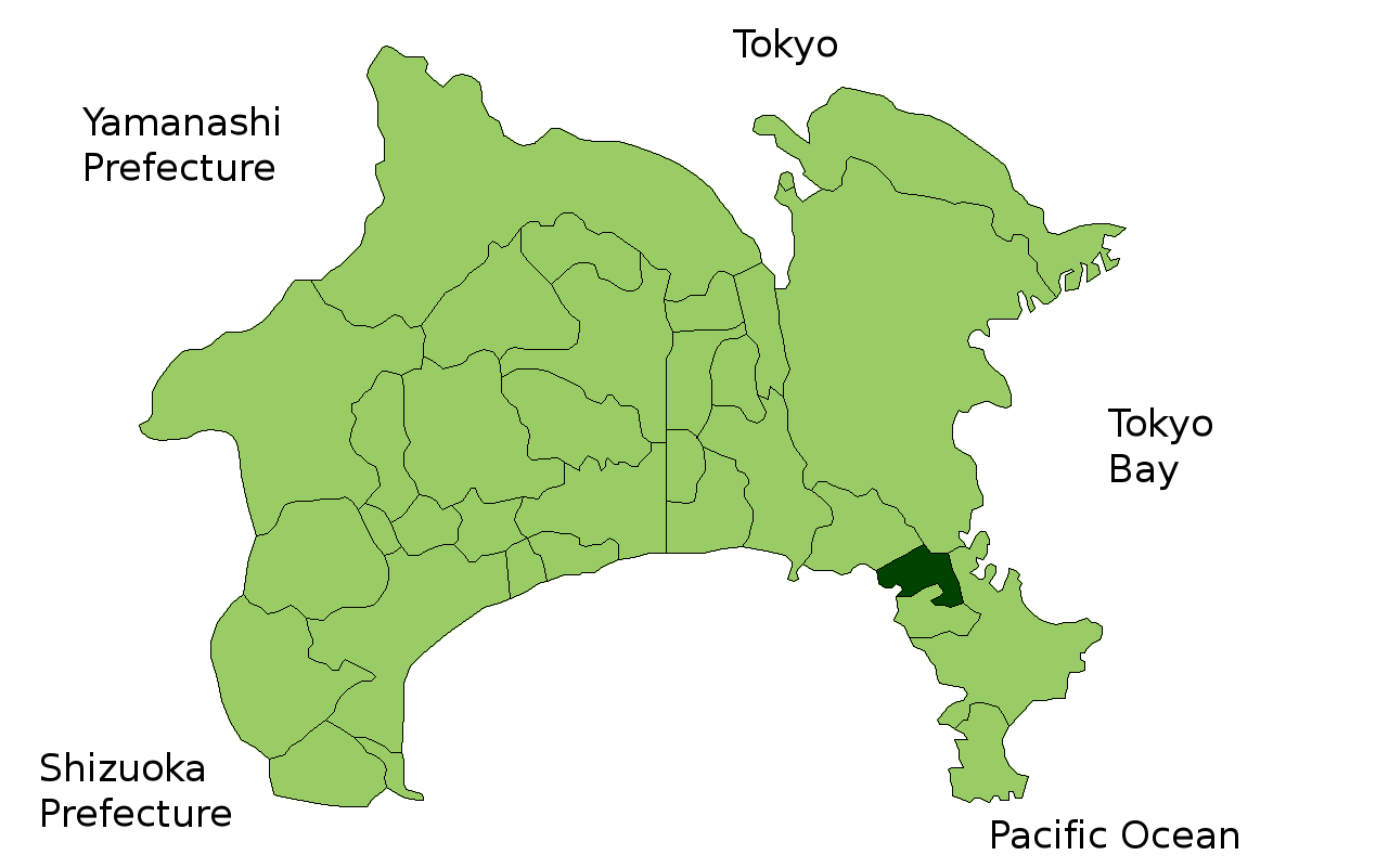


Elevation=

Zushi (逗子市 "Zushi-shi") is a city located in Kanagawa, Japan.

As of 2003, the city has an estimated population of 58,597 and a density of 3,379.30 persons per km². The total area is 17.34 km².

City status was gained on April 15, 1954.

Zushi is a popular beach resort, and can be accessed via the JR Yokosuka Line and the Keikyu Line. There are two main railway stations in Zushi; Zushi Station, where the JR Yokosuka Line comes in and which lies in the center of town, and Shin-Zushi Station, where the Keikyu line comes in and which lies south of the center of town.In modern times many famous writers (e.g. Roka Tokutomi) lived in Zushi.

Zushi's Hiroyama Kōen neighborhood is well known as a fashionable place for Tokyo's elite to own second homes. Among residents are well-known right-wing governor of Tokyo and writer Shintaro Ishihara and his (deceased) actor brother Yujiro Ishihara and TV personality Mino Monta.

Zushi is home to the U.S. Navy's Ikego family housing area. Ikego was a former Japanese Imperial Navy ammunition magazine, and covers about 710 acres, 210 of which are used for Navy housing. Ikego opened in April 1996, and contains 854 housing units with approximately 3,400 family members living on the base. It is located twelve kilometers from the Yokosuka Naval Base. Driving between Ikego and Yokosuka takes about 30 minutes without traffic.

Government and politics

* Zushi mayoral election, 2006

Points of interest

* Ganden-ji, number two of the Bandō Sanjūsankasho
* Hosshō-ji, Nichiren temple that is supposed to lie on the spot where the master was succored by three white monkeys.

External links

* [http://www.city.zushi.kanagawa.jp/ Official website] in Japanese
* [http://www.cfay.navy.mil/ikego.htm U.S. Navy Ikego community site] in English


Wikimedia Foundation. 2010.

Игры ⚽ Поможем решить контрольную работу

Look at other dictionaries:

  • Zushi — shi 逗子市 Geographische Lage in Japan …   Deutsch Wikipedia

  • Zushi mayoral election, 2006 — The city of Zushi, Kanagawa Prefecture, Japan held a mayoral election on December 10, 2006. The election was won by the Democratic Party of Japan candidate, Ryūichi Hirai. Election box begin | title=Mayoral election 2006: Zushi Election box… …   Wikipedia

  • Zushi — shi (逗子市) Port de Zushi. Administration Pays Japon Région Kantō Préfecture …   Wikipédia en Français

  • Kanagawa Prefectural Board of Education — (神奈川県教育委員会) is the board of education of the Kanagawa Prefecture, Japan.The board consists of six members; one of them is elected as the chair (教育委員長), and one of them is appointed by the board as the superintendent (教育長).The board administers to …   Wikipedia

  • Kanagawa — Préfecture de Kanagawa Préfecture de Kanagawa · 神奈川県 Kanagawa ken Carte du Japon avec la Préfecture de Kanagawa mise en évidence. Pays  Japon …   Wikipédia en Français

  • Zushi Station — infobox japan station caption=Zushi Station entrance name=逗子 namerom=Zushi open=1889 pref=Kanagawa city=Zushi address=1 chome, Zushi jaloc=神奈川県逗子市逗子1丁目 postal=249 0006 line=Yokosuka Line Shōnan Shinjuku Line operator=East Japan Railway Company… …   Wikipedia

  • Shin-Zushi Station — is a railway station located in Zushi, Kanagawa Prefecture, Japan.LinesShin Zushi Station is served by the following line:*Keihin Electric Express Railway **Keikyū Zushi Linetation layoutKeikyū platforms.Adjacent… …   Wikipedia

  • Prefectura de Kanagawa — Kanagawa 神奈川県 Kanagawa ken Prefectura de Japón …   Wikipedia Español

  • Miura District, Kanagawa — Map of Miura District with Meiji period area in yellow, modern area in green Miura District (三浦郡, Miura gun?) is an administrative district …   Wikipedia

  • Kamakura, Kanagawa — Infobox City Japan Name= Kamakura JapaneseName= 鎌倉市 Map Region= Kantō Prefecture= Kanagawa District= Area km2= 39.60 PopDate= January 2008 Population= 173,588 Density km2= 4380 Coords= LatitudeDegrees= 35 LatitudeMinutes= 19 LatitudeSeconds=… …   Wikipedia

Share the article and excerpts

Direct link
Do a right-click on the link above
and select “Copy Link”