- Montana Territory
-
For the film, see Montana Territory (film).
Territory of Montana Organized incorporated territory of the United States ← 
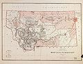
1864–1889  →Montana Territory, 1879
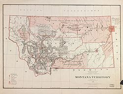
Capital Helena (1875-1889) Government Organized incorporated territory History - Split from Idaho Territory May 28 1864 - Statehood November 8 1889 The Territory of Montana was an organized incorporated territory of the United States that existed from May 28, 1864, until November 8, 1889, when it was admitted to the Union as the State of Montana.
Contents
History
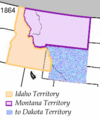
The Montana Territory was organized out of the existing Idaho Territory by Act of Congress and signed into law by President Abraham Lincoln on May 26, 1864. The areas east of the Continental Divide had been previously part of the Nebraska Territory and Dakota Territory and had been acquired by the United States in the Louisiana Purchase.
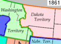
The territory also included a portion of the Idaho Territory west of the continental divide and east of the Bitterroot Range, which had been acquired by the United States in the Oregon Treaty, and originally included in the Oregon Territory. The part of the Oregon Territory that became part of Montana had been split off as part of the Washington Territory.
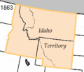
The boundary between the Washington Territory and Dakota Territory was the Continental Divide (as shown on the 1861 map), however the boundary between the Idaho Territory and the Montana Territory followed the Bitterroot Range north of 46°30'N (as shown on the 1864 map). Popular legend says a drunken survey party followed the wrong mountain ridge and mistakenly moved the boundary west into the Bitterroot Range.
Contrary to legend, the boundary is precisely where the United States Congress intended. The Organic Act of the Territory of Montana[1] defines the boundary as extending from the modern intersection of Montana, Idaho, and Wyoming at:
“ The forty-fourth degree and thirty minutes of north latitude; thence due west along said forty-fourth degree and thirty minutes of north latitude to a point formed by its intersection with the crest of the Rocky Mountains; thence following the crest of the Rocky Mountains northward till its intersection with the Bitter Root Mountains; thence northward along the crest of the Bitter Root Mountains to its intersection with the thirty-ninth degree of longitude west from Washington; thence along said thirty-ninth degree of longitude northward to the boundary line of British possessions. ” The boundaries of the territory did not change during its existence. It was admitted to the Union as the State of Montana on November 8, 1889.
-
-
-
-
-
The reorganization of the Idaho Territory starting in 1864, showing the newly-created Montana Territory.
See also
- American Civil War, 1861–1865
- Governors of Montana Territory
- Historic regions of the United States
- History of Montana
- Montana Territory's At-large congressional district
- Rocky Mountains
- Territorial evolution of the United States
- Territory of France that encompassed land that would later become part of the Territory of Montana:
- Louisiane, 1682–1764 and 1803
- Territory of Spain that would later be returned to France:
- Luisiana, 1764–1803
- Territory of the United Kingdom that encompassed land that would later become part of the Territory of Montana:
- Rupert's Land, 1670–1870
- International territory that encompassed land that would later become part of the Territory of Montana:
- Oregon Country, 1818–1846
- U.S. territories that encompassed land that would later become part of the Territory of Montana:
- Louisiana Purchase, 1803–1804
- District of Louisiana, 1804–1805
- Territory of Louisiana, 1805–1812
- Territory of Missouri, 1812–1821
- Provisional Government of Oregon, 1843-1849 (extralegal)
- Territory of Oregon, 1848–1859
- Territory of Washington, 1853–1889
- Territory of Nebraska, 1854–1867
- Territory of Dakota, 1861–1889
- Territory of Idaho, 1863–1890
- U.S. state created from the Territory of Montana:
- State of Montana, 1889
- Territory of France that encompassed land that would later become part of the Territory of Montana:
- William F. Wheeler, U.S. Marshal of the Montana Territory
- Lone Teepee A historic place in America.
References
- ^ "An Act to provide a temporary Government for the Territory of Montana" (PDF). Thirty-sixth United States Congress. 1864-05-26. Archived from the original on 2007-01-12. http://web.archive.org/web/20070112223516/http://courts.mt.gov/library/organic.pdf. Retrieved 2007-01-20.
External links
 State of Montana
Helena (capital) Topics Index · History · Governors · People · Geography · State Government · Delegations · Visitor Attractions
Society Crime · Demographics · Economy · Education · Politics
Regions The Flathead · Glacier National Park · Regional designations of Montana · Western Montana · Yellowstone
Largest cities Counties Beaverhead · Big Horn · Blaine · Broadwater · Carbon · Carter · Cascade · Chouteau · Custer · Daniels · Dawson · Deer Lodge · Fallon · Fergus · Flathead · Gallatin · Garfield · Glacier · Golden Valley · Granite · Hill · Jefferson · Judith Basin · Lake · Lewis and Clark · Liberty · Lincoln · Madison · McCone · Meagher · Mineral · Missoula · Musselshell · Park · Petroleum · Phillips · Pondera · Powder River · Powell · Prairie · Ravalli · Richland · Roosevelt · Rosebud · Sanders · Sheridan · Silver Bow · Stillwater · Sweet Grass · Teton · Toole · Treasure · Valley · Wheatland · Wibaux · Yellowstone
Categories:- States and territories established in 1864
- States and territories disestablished in 1889
- Montana Territory
-


Wikimedia Foundation. 2010.