- Des Moines River
-
Des Moines River River  The Des Moines River upstream of Ottumwa, Iowa
Country United States State Iowa Source - coordinates 44°05′02″N 95°41′17″W / 44.0839°N 95.6881°W Mouth Mississippi River - location Clark County, Missouri / Lee County, Iowa, near Keokuk, Iowa - elevation 597 ft (182 m) - coordinates 40°22′52″N 91°25′21″W / 40.3812°N 91.4224°W Length 525 mi (845 km) Basin 14,802 sq mi (38,337 km2) Discharge - average 8,678 cu ft/s (246 m3/s)  The Des Moines River watershed
U.S. Geological Survey Geographic Names Information System: Des Moines River The Des Moines River is a tributary river of the Mississippi River, approximately 525 miles (845 km) long to its farther headwaters,[1] in the upper Midwestern United States. The largest river flowing across the state of Iowa, it rises in southern Minnesota, and flows across Iowa from northwest to southeast, passing from the glaciated plains into the unglaciated hills near the city of Des Moines, which takes its name from the river. It forms a short portion of Iowa's border with Missouri in Lee County. The Avenue of the Saints passes over this section.
Contents
Hydrography
The Des Moines River rises in two forks. The West Fork (the main branch) rises out of Lake Shetek in Murray County in southwestern Minnesota. It flows south-southeast into Emmet County, Iowa, past Estherville. The East Fork rises out of Okamanpeedan Lake in northern Emmet County on the Iowa-Minnesota border and flows south, through Algona.
The two forks join in southern Humboldt County, approximately 5 miles (8 km) south of Humboldt at Frank Gotch State Park. The combined stream flows roughly southward through Fort Dodge. South of Boone it passes through the Ledges State Park. It flows through downtown Des Moines, then turns generally southeastward, flowing through Ottumwa. It forms approximately 20 miles (32 km) of the border between Iowa and Missouri before joining the Mississippi from the northwest at Keokuk.
It receives the Boone River from the northeast approximately 20 miles (32 km) southwest of Fort Dodge. It receives the Raccoon River from the west in Des Moines. Above the city of Des Moines, it is impounded to create the Saylorville Lake reservoir. About midway below Saylorville and above Ottumwa, near Pella, it is impounded to create the Lake Red Rock reservoir.
History
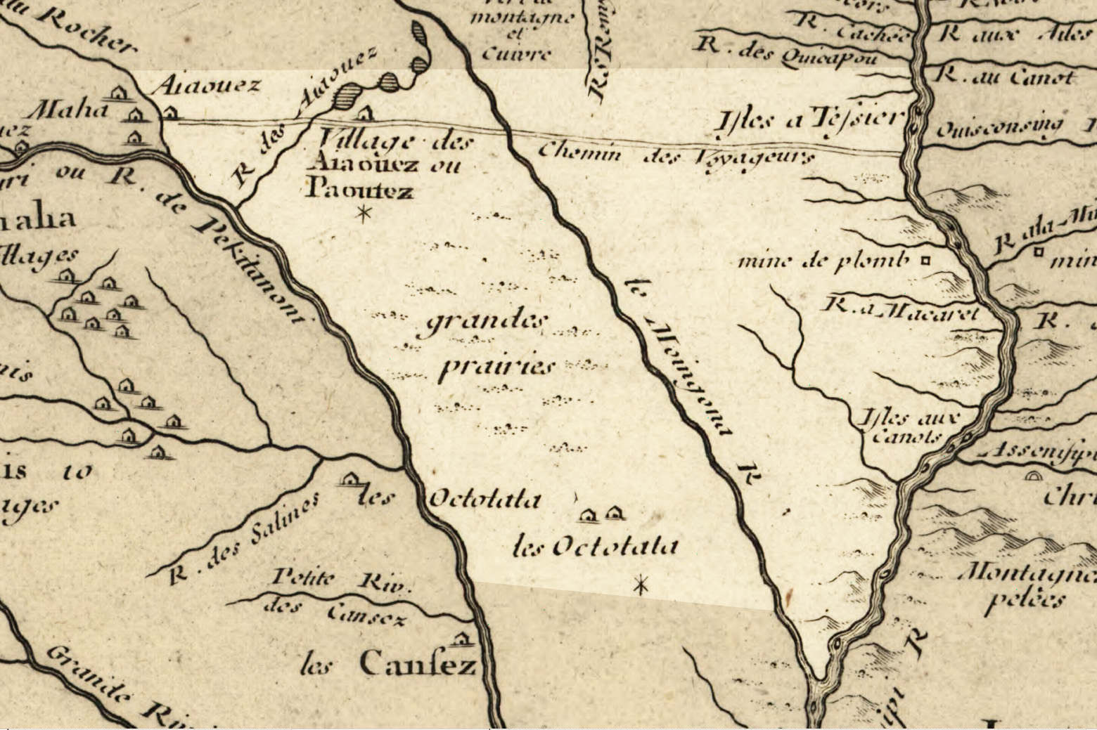
 The Des Moines as it was depicted in 1718 by Guillaume Delisle; modern Iowa highlighted.
One of the earliest French maps that depicts the Des Moines (1703) refers to it as "R. des Otentas" which translates to "River of the Otoe"; the Otoe Tribe lived in the interior of Iowa in the 18th century.[2] Another early name used by the Meskwaki and Sauk was "Ke-o-shaw-qua", (lit. Hermit's River) from which Keosauqua, Iowa derives its name.[3]
The origin of the name "Des Moines" is obscure. It was given the name La Rivière des Moines, literally meaning "River of the Monks", by early French explorers. The name may have referred to early Trappist monks who built huts near the mouth of the river. It may also refer to moingona, an American Indian word meaning "river of the mounds" in reference to the burial mounds that were located near the banks of the river.[citation needed] The 1718 Guillaume Delisle map (pictured) labels it "le Moingona R."
It is also claimed that the name "des Moines" is the result of a hoax. In 1673 Father Jacques Marquette met some representatives of the Peoria tribe near the mouth of the modern-day Des Moines River. He asked them the name of the rival tribe that lived further along the banks of the river. The Peoria told him that tribe was called the Moingoana, which became the root for the word 'Moines'. But researcher Michael McCafferty of Indiana University, while studying the now extinct Miami-Illinois language, discovered that Moingoana, translated literally, meant "shit faces".[1]
During the mid-19th century, the river provided the main commercial transportation across Iowa until the building of the railroads in the 1860s.
Flooding
 The Des Moines River, as it flow through downtown Des Moines, west bank, during spring high water; note the old watermarks on the flood wall.
There has been a history of flooding from the river. For example, in May 1944 the Riverview Park had just opened for the season on May 19, 1944. At around dawn on May 23, the levee began to collapse. The river was too much to hold back. Quickly the breach in the levee grew to nearly 100 feet (30 m) wide, and the river water quickly enveloped all of the park and the surrounding area.[4]
The Great Flood of 1993 on the river and its tributary the Raccoon in the summer of 1993 forced the evacuation of much of the city of Des Moines and nearby communities. On June 13, 2008, officials issued a voluntary evacuation order for much of downtown and other areas bordering the Des Moines River. The river had reached flood stage in many locations, and Mayor Frank Cownie said the evacuations were an attempt "to err on the side of citizens and residents."
Cities and towns
- Algona, Iowa (East Fork)
- Armstrong, Iowa (East Fork)
- Bonaparte, Iowa
- Bradgate, Iowa (West Fork)
- Chillicothe, Iowa
- Currie, Minnesota
- Dakota City, Iowa (East Fork)
- Des Moines, Iowa
- Douds, Iowa
- Eddyville, Iowa
- Eldon, Iowa
- Estherville, Iowa (West Fork)
- Farmington, Iowa
- Fort Dodge, Iowa
- Fraser, Iowa
- Graettinger, Iowa (West Fork)
- Humboldt, Iowa (West Fork)
- Irvington, Iowa (East Fork)
- Jackson, Minnesota
- Johnston, Iowa
- Keokuk, Iowa
- Keosauqua, Iowa
- Leando, Iowa
- Lehigh, Iowa
- Livermore, Iowa (East Fork)
- Ottumwa, Iowa
- Petersburg, Minnesota (West Fork)
- Rutland, Iowa (West Fork)
- St. Joseph, Iowa (East Fork)
- Windom, Minnesota
Variant names
According to the Geographic Names Information System, the Des Moines River has also been known as:
- La Riviere des Moins
- Le Moine River
- Monk River
- Nadouessioux River
- Outontantes River
- River Demoin
- River of the Maskoutens
- River of the Peouareas
See also
- List of Iowa rivers
- List of longest rivers of the United States (by main stem)
- List of Minnesota rivers
- List of Missouri rivers
- Illinois Country
- French colonization of the Americas
References and notes
- ^ U.S. Geological Survey. National Hydrography Dataset high-resolution flowline data. The National Map, accessed May 26, 2011
- ^ Lahontan, Louis Armand de Lom d'Arce (1703) Carte de la Riviere Longue: et de Quelques Autres, qui se Dechargent dans le Grand Fleuve de Missisipi. La Haye, Netherlands. On file, Library of Congress Geography and Map Division Washington.
- ^ Isaac Galland, 1840, Galland's Iowa emigrant: containing a map, and general descriptions of Iowa, p 6-7.
- ^ Riverview Park Flood
External links
Categories:- Rivers of Iowa
- Rivers of Minnesota
- Rivers of Missouri
- Tributaries of the Mississippi River
- Borders of Iowa
- Borders of Missouri
- Geography of Cottonwood County, Minnesota
- Geography of Lee County, Iowa
- Geography of Murray County, Minnesota
- Geography of Emmet County, Iowa
- Geography of Kossuth County, Iowa
- Geography of Humboldt County, Iowa
- Geography of Webster County, Iowa
- Geography of Boone County, Iowa
- Geography of Wapello County, Iowa


Wikimedia Foundation. 2010.