- Achill Island
-
Achill Native name: Acaill, Oileán Acla 
View of the Island using NASA's technology overhead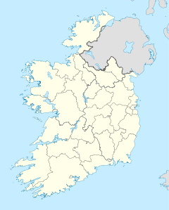
 Achill Island (Ireland)
Geography Location Atlantic Ocean Coordinates 53.°57.54′N 10°2.34′W / 53.959°N 10.039°WCoordinates: 53.°57.54′N 10°2.34′W / 53.959°N 10.039°W Archipelago Achill Total islands 3(Achill,Innisbiggle and Achillbeg islands) Major islands Achill Area 35,283 acres (14,279 ha) Coastline 128 km (79.5 mi) Highest elevation 688 m (2,257 ft) Highest point Croaghaun Country Republic of IrelandProvince Connacht County Mayo Barony Burrishoole Demographics Population 2,700 (as of 2006) Density 18.2 /km2 (47.1 /sq mi) Additional information Irelands largest island Achill Island
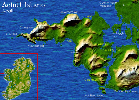
 /ˈækəl/ (Irish: Acaill, Oileán Acla) in County Mayo is the largest island off the coast of Ireland, and is situated off the west coast. It has a population of 2,700. Its area is 148 km2 (57 sq mi). Achill is attached to the mainland by Michael Davitt Bridge, between the villages of Gob an Choire (Achill Sound) and Poll Raithní (Polranny). A bridge was first completed here in 1887, and replaced by the current structure in 1949. Other centres of population include the villages of Keel, Dooagh, Dumha Éige (Dooega) and Dugort. The parish's main Gaelic football pitch and two secondary schools are on the mainland at Poll Raithní. Early human settlements are believed to have been established on Achill around 3000 BC. A paddle dating from this period was found at the crannóg near Dookinella. The island is 87% peat bog. The parish of Achill also includes the Curraun peninsula. Some of the people of Curraun consider themselves Achill people, and most natives of Achill refer to this area as being "in Achill". Big Rivalry exists between the two areas, due to Curraun not being ON the Island. In the summer of 1996, the RNLI decided to station a lifeboat at Kildownet.
Contents
History
It is believed that at the end of the Neolithic Period (around 4000 BC), Achill had a population of 500–1,000 people. The island would have been mostly forest until the Neolithic people began crop cultivation. Settlement increased during the Iron Age, and the dispersal of small forts around the coast indicate the warlike nature of the times. Granuaile maintained a castle at Kildownet in the 16th century.
Achill Island lies in the Barony of Burrishoole, in the territory of ancient Umhall (Umhall Uactarach and Umhall Ioctarach), that originally encompassed an area extending from the Galway/Mayo border to Achill Head in Co. Mayo.
The hereditary chieftains of Umhall were the O’Malleys, recorded in the area in 814 AD when they successfully repelled an onslaught by the Vikings in Clew Bay. The Anglo/Norman invasion of Connacht in 1235 AD saw the territory of Umhall taken over by the Butlers and later by the de Burgos. The Butler Lordship of Burrishoole continued into the late 14th century when Thomas le Botiller was recorded as being in possession of Akkyll & Owyll.
In the 17th and 18th centuries, there was much migration to Achill from other parts of Ireland, particularly Ulster, due to the political and religious turmoil of the time. For a while there were two different dialects of Irish being spoken on Achill. This led to many townlands being recorded as having two names during the 1824 Ordnance Survey, and some maps today give different names for the same place. Achill Irish still has many traces of Ulster Irish.
Archaeology
Achill Archaeological Field School is based at the Achill Archaeology Centre in Dooagh, which has served as a catalyst for a wide array of archaeological investigations on the island. It was founded in 1991 and is a training school for students of archaeology and anthropology. Since 1991, several thousand students from 21 countries have come to Achill to study and participate in ongoing excavations. The school is involved in a study of the prehistoric and historic landscape at Slievemore, incorporating a research excavation at a number of sites within the deserted village of Slievemore. Slievemore is rich in archaeological monuments that span a 5,000 year period from the Neolithic to the Post Medieval.[1] Recent archaeological research suggests the village was occupied year-round at least as early as the 19th century, though it is known to have served as a seasonally occupied booley village by the first half of the 20th century. A booley village (a number of which exist in a ruined state on the island) is a village occupied only during part of the year, such as a resort community, a lake community, or (as the case on Achill) a place to live while tending flocks or herds of ruminants during winter or summer pasturing.[2] Specifically, some of the people of Dooagh and Pollagh would migrate in the summer to Slievemore and then go back to Dooagh in the autumn. The summer 2009 field school excavated Round House 2 on Slievemore Mountain under the direction of archaeologist Stuart Rathbone. Only the outside northwall, entrance way and inside of the Round House were completely excavated.[3]
From 2004 to 2006, the Achill Island Maritime Archaeology Project directed by Chuck Meide was sponsored by the College of William and Mary, the Institute of Maritime History, the Achill Folklife Centre (now the Achill Archaeology Centre), and the Lighthouse Archaeological Maritime Program (LAMP). This project focused on the documentation of archaeological resources related to Achill's rich maritime heritage. Maritime archaeologists recorded 19th century fishing station, ice house, and boat house ruins, a number of anchors which had been salvaged from the sea, 19th century and more recent currach pens, a number of traditional vernacular watercraft including a possibly 100-year old Achill yawl, and the remains of four historic shipwrecks.[4]
Places of interest
Despite some unsympathetic development, the island retains some striking natural beauty. The cliffs of Croaghaun on the western end of the island are the third highest sea cliffs in Europe but are inaccessible by road. Near the westernmost point of Achill, Achill Head, is Keem Bay. Keel Beach is quite popular with tourists and some locals as a surfing location. South of Keem beach is Moytoge Head, which with its rounded appearance drops dramatically down to the ocean. An old British observation post, built during World War I to prevent the Germans from landing arms for the Irish Republican Army, is still standing on Moytoge. During the Second World War this post was rebuilt by the Irish Defence Forces as a Look Out Post for the Coast Watching Service wing of the Defence Forces. It operated from 1939 to 1945.[5]
 Slievemore mountain dominates the centre of the island
The mountain Slievemore (672 m) rises dramatically in the north of the island and the Atlantic Drive (along the south/west of the island) has some dramatically beautiful views. On the slopes of Slievemore, there is an abandoned village (the "Deserted Village") The Deserted Village is traditionally thought to be a remnant village from An Gorta Mór (The Great Hunger of 1845-1849).
Just west of the deserted village is an old Martello tower, again built by the British to warn of any possible French invasion during the Napoleonic Wars. The area also boasts an approximately 5000-year old Neolithic tomb. Achillbeg (Acaill Beag, Little Achill) is a small island just off Achill's southern tip. Its inhabitants were resettled on Achill in the 1960s.[6]
The villages of Dooniver and Askill have very picturesque scenery and the cycle route is popular with Tourists.
Economy
While a number of attempts at setting up small industrial units on the island have been made, the economy of the island is largely dependent on tourism. Subventions from Achill people working abroad, in particular in the United Kingdom the United States and Africa allowed many families to remain living in Achill throughout the 19th and 20th centuries.[citation needed] Since the advent of Ireland's "Celtic Tiger" economy fewer Achill people were forced to look for work abroad. Agriculture plays a small role and the fact that the island is mostly bog means that its potential for agriculture is limited largely to sheep farming. In the past, fishing was a significant activity but this aspect of the economy is small now. At one stage, the island was known for its shark fishing, basking shark in particular was fished for its valuable liver oil. There was a big spurt of growth in tourism in the 1960s and 1970s before which life was tough and difficult on the island. Despite healthy visitor numbers each year, the common perception is that tourism in Achill has been slowly declining since its heyday. Currently the largest employers on Achill are two hotels and a call centre.[7] In late 2009 Ireland's only Turbot farm opened in the Bunnacurry Business Park.
Religion
Most people on Achill are either Roman Catholic or Church of Ireland. There are three priests on Achill and eight churches in total.
- Catholic:
- Bunnacurry Church (Saint Josephs)
- Valley Church
- Dookinella Church
- Currane Church
- Pollagh Church
- Derreens Church
- Dooega Church
- Belfarsed Church
- Achill Sound Church
- Islamic:
- Currane Mosque
- Jedi:
- Sáile Temple
- Church of Ireland:
- Dugort Church (St.Thomas's church)
- Innisbiggle Island church
Education
In Achill there were two post primary schools Mc Hale College and Scoil Damhnait. However in August,2011 the two schools amalgamated to form Colaiste Pobail Acla. There are nine National Schools
Transport
- Achill railway station opened on 13 May 1895, but finally closed on 1 October 1937.[8]
- The Great Western Greenway is a greenway rail trail that follows the line of the former Midland Great Western Railway branch line from Westport to Achill via Newport and Mulranny.[9]
- Bus Éireann 440 provides daily commutes to Westport and beyond from the island's scattered villages.
- Bus Éireann provide transport for the areas secondary school children
- There are many Taxicab and Hackney carriage services on the Island
Cuisine
As a popular tourist destination Achill has many bars, cafes and restaurants which serve a full range of food. However with the islands Atlantic location seafood is a speciality on Achill with common foods including salmon, lobster, mussels and trout. With a large sheep population, Achill lamb is a very popular meal on the island too. Furthermore Achill has a big population of cows which produces excellent beef.[citation needed]
Sport
Achill has a GAA, football club which competes in the intermediate championship and division 1C of the Mayo League. Achill Rovers who compete in the Mayo & District League Welcome Inn Hotel Division 1 and Achill Golf Club. Card games, including Whist and 24 card game are also popular on Achill.[10] The island's primary recreational outdoor center is Achill Outdoor Education Centre. Achill Island's rugged landscape and the surrounding ocean offers one of the most perfect locations for outdoor adventure activities in Europe from surfing and kitesurfing on Keel Beach to sea kayaking on the north shore. Fishing and watersports are popular with tourists and locals alike. Sailing regattas featuring a local vessel type, the Achill Yawl, have been popular since the 19th century, though most present-day yawls, unlike their traditional working boat ancestors, have been structurally modified to promote greater speed under sail. The island's waters and striking underwater sites are occasionally visited by scuba divers, though Achill's unpredictable weather generally has precluded a commercially successful recreational diving industry.
Population
In 2006, the population was 2,701. The island's population has declined from around 6,000 before the Great Hunger.
Architecture
Because of the inhospitable climate, few inhabited houses date from before the 20th century, though there are many examples of abandoned stone structures dating to the 19th century.
 The "Deserted Village" at the foot of Slievemore was a Booley village; see Transhumance
 The location of the village is relatively sheltered
The best known of these earlier can be seen in the "Deserted Village" ruins near the graveyard at the foot of Slievemore. Even the houses in this village represent a relatively comfortable class of dwelling as, even as recently as a hundred years ago, some people still used "Beehive" style houses (small circular single roomed dwellings with a hole in ceiling to let out smoke).
Many of the oldest and most picturesque inhabited cottages date from the activities of the Congested Districts Board for Ireland—a body set up around the turn of the 20th century in Ireland to improve the welfare for inhabitants of small villages and towns. Most of the homes in Achill at the time were very small and tightly packed together in villages. The CDB subsidised the building of new, more spacious (though still small by modern standards) homes outside of the traditional villages.
Some of the recent building development on the island (over the last 30 years or so) has been contentious and in many cases is not as sympathetic to the landscape as the earlier style of whitewashed raised gable cottages. Because of generous tax incentives, many holiday homes have been built over the last ten years. This building boom has brought benefits but at a cost. On the one hand it has provided much-needed employment for the local people, has increased the demand and value for suitable development land and has allows the island to support more tourists. On the other hand, many of these houses have been built in prominent scenic areas and have damaged traditional views of the island while lying empty for most of the year. They may also be contributing to the declining fortunes for the traditional beneficiaries of tourism - bed and breakfasts, public houses and guesthouses.
Notable people
- Manus Sweeney from Achill was hanged by the British in Newport for his part in the 1798 rebellion. There is a monument to him at the eastern end of Keel beach.
- The artist Paul Henry stayed on the island for a number of years in the early 1900s and some of his most famous paintings are of the dramatic landscape of the island. Not long after arriving, he threw his return train ticket into the sea near Purteen Harbour.
- The Nobel Prize winning author, Heinrich Böll, visited the island and wrote of his experience in his "Irish Journal" (Irisches Tagebuch). The Bölls later bought a cottage near Dugort and lived in it periodically until 2001 when they donated it to be used as an artists' residence.
- Novelist Graham Greene, visited and stayed on Achill Island a number of times in the late 1940s. He wrote parts of the novels The Heart of the Matter (subsequently banned in Ireland) and The Fallen Idol in Dooagh, and Achill Island is also said to have inspired Greene to write some of his best poetry. He retained a special affection for Achill Island, which he mentioned frequently in his letters and notes, although this was largely due to the circumstances of his visits, as he was introduced to Achill by his mistress, Catherine Walston. She rented a cottage in Dooagh, with no electricity, one outside tap for water, and a corrugated iron roof on the traditional stone cottage, now since demolished.[11]
- Artist Robert Henri came to Achill on a regular basis in the early decades of the 20th century. It was during his early trips to Achill prior to the outbreak of World War I that Henri painted extensively and is reputed to have done portraits of almost all the children in Dooagh village. He bought Corrymore House on the hill above Dooagh in 1924. He died in America in 1929.[12]
- Thomas Patten from Dooega died fighting Francisco Franco's fascist forces during the Siege of Madrid in December 1936. There is a monument to him in his native village.
- English writer Honor Tracy lived there until her death in 1989.
- In the centre of Dooagh is a commemoration plaque to Don Allum, the first man to row across the Atlantic Ocean in both directions. He landed close to the memorial on Dooagh beach on 4 September 1987, completing the second leg of his voyage.[13]
- Footballers Kevin Kilbane (Hull City AFC) and (Football Association Of Ireland), Darren Fletcher (Manchester United) and Scottish FA), John Joe O Toole (Colchester Utd and FAI U21 player and Manchester United's wonder youth defender 16 year old Seán McGinty and U 19 Rep Ireland player parents hail from the island.
- Mid West Radio DJ Tim Norton comes from the Currane peninsula.
- Singer James Kilbane, also known for his research on traditional Achill watercraft, lives on the island. Other notable residents include country and western starlet Ciara Levelle, whose bid for the 2008 eurovision contest was dashed after losing to Dustin the Turkey.
Literature
Heinrich Böll: Irisches Tagebuch, Berlin 1957
Kingston, Bob: The Deserted Village at Slievemore, Castlebar 1990
McDonald, Theresa: Achill: 5000 B.C. to 1900 A.D. Archeology History Folklore, I.A.S. Publications [1992]
Meehan, Rosa: The Story of Mayo, Castlebar 2003
Carney, James: The Playboy & the Yellow lady, 1986 POOLBEG[14]See also
- Dooniver
- Connacht Irish
- Saula
- Askill
- Bunnacurry
- Dooagh
- Achill Sound
- List of RNLI stations
- Mid West Radio
- James Kilbane
- Achill Rovers
References
- ^ "Achill Archaeological Field School 2009". Achill Archaeological Field School. http://www.achill-fieldschool.com/. Retrieved 7 March 2009.
- ^ Deserted village, Slievemore, Achill Island, achill247.com Retrieved on 2008-02-17.
- ^ Amanda Burt, member of Achill Field School, Summer 2009.
- ^ http://www.maritimehistory.org/content/achill-island-maritime-archaeology-project
- ^ See Michael Kennedy, 'Guarding Neutral Ireland' (Dublin, 2008), p. 50
- ^ Jonathan Beaumont (2005), Achillbeg: The Life of an Island, ISBN 0-85361-631-0
- ^ http://www.irelandbyways.com/top-irish-peninsulas/the-west/the-western-isles/achill-island-co-mayo/
- ^ "Achill station" (pdf). Railscot - Irish Railways. http://www.railscot.co.uk/Ireland/Irish_railways.pdf. Retrieved 2007-09-08.
- ^ "Home". Great Western Greenway. http://www.greenway.ie/. Retrieved 10 August 2011.
- ^ http://www.achilltourism.com/dwl/achill-weekly-flyer-0503-1203-2010.pdf
- ^ "Graham Greene & Achill Island". Achill 24/7. http://www.achill247.com/writers/ggreene.html. Retrieved 7 March 2009.
- ^ "Their portraits are famous in America but - Whatever happened to the Commins family of Achill?". Western People - 1 April 1998. http://archives.tcm.ie/westernpeople/1998/04/01/News.htm. Retrieved 7 March 2009.
- ^ "Don Allum". Doc Brown.info. http://www.docbrown.info/docspics/irishviews/ivpage115.htm. Retrieved 7 March 2009.
- ^ http://openlibrary.org/b/OL2431852M/playboy_the_yellow_lady
External links
- Achill Island Maritime Archaeology Project
- Achill Archaeological Field School web site
- VisitAchill multilingual visitor's site
- [1] Dooniver's officeal website
- [2] In this series of podcasts on Mayo's Heritage you can hear an excerpt from John Mc Hugh's Heritage Tour of Achill (ref Programme 6 & Programme 8)
Mountains and hills of Connacht List of mountains in Ireland Achill Island 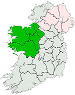
Dartry Mountains Benbulbin • TruskmoreMaumturks Nephin Range Ox Mountains KnockalongyPartry Mountains Sheeffry Range Twelve Bens Benbaun • Bencorr • ErrisbegOthers Categories:- Islands of County Mayo
- Achill Island
- Gaeltacht places in County Mayo
- Catholic:


Wikimedia Foundation. 2010.