- Mamaroneck (Metro-North station)
-
Mamaroneck 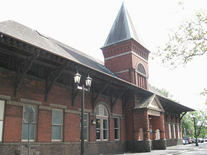
Station houseStation statistics Address 1 Station Plaza,
Mamaroneck, NY 10543Coordinates 40°57′18″N 73°44′10″W / 40.955109°N 73.736115°W Lines Connections Bee-Line Bus System: 60, 61 Platforms 2 side platforms Tracks 4 Parking 623 spaces Bicycle facilities Y Other information Opened 1888 Electrified 12,500V (AC) overhead catenary Owned by Metropolitan Transportation Authority Fare zone 13 Traffic Passengers (2006) 621,920[1]  0%
0%Services Preceding station Metro-North Railroad Following station toward Grand CentralNew Haven Line toward New Haven – State StreetMamaroneck Metro-North Railroad station serves Mamaroneck, New York, via the New Haven Line. Mamaroneck is 20.5 miles (33.0 km) from Grand Central Terminal and the average travel time from Grand Central is 43 minutes.
Contents
History
The former Romanesque station building, near the north end of the inbound (to Grand Central Terminal) platform, was constructed in 1888, making it the second oldest surviving station building on the New Haven Line, according to a plaque inside the building.
The station building was originally located at track level next to the New York, New Haven and Hartford Railroad (NH) platforms. The building was moved down an embankment to its present location in the 1920s to accommodate the construction of the New York, Westchester and Boston Railway (NYW&B) and separate underground tunnels connected the building to the respective railroad's platforms.[2]
Subsequent to the abandonment of the NYW&B in 1937, the area formerly occupied by the building and NYW&B platforms and tracks was converted to parking, and the building remained at the bottom of the embankment on Station Plaza, adjacent to Columbus Park. The tunnel to the NYW&B was sealed, and the exits to the former NYW&B platforms covered. The tunnel to the NH platforms remained open. Unlike many other stations on the line, the Mamaroneck station does not include a pedestrian overpass.
The station was updated in the early 1970s from low-level to high-level platforms. This was done to accommodate the arrival of new rail cars known then as Cosmopolitans, now more commonly known as M2s. The new cars did not include boarding steps, or traps, as their predecessor 4400 Pullman "Washboard" cars did, and could only board passengers at stations with high-level platforms. The update was done in two phases, with the eastern half of the station upgraded first; then the western half.
For the 2006 U.S. Open golf tournament at the nearby Winged Foot Golf Club, the usually-local Mamaroneck station temporarily became an express station. During this period, Shore Line East runs which usually terminate in Stamford were extended to Mamaroneck as well.
The station building was closed October 9, 2007 by its owner Metro-North Railroad after removal of the ticket agent and in preparation for its sale. Tickets are now sold through a ticket vending machine located adjacent to the platform.[1] The NH tunnel between the inbound platform and station building is closed by a chain-link fence.
The station building was subsequently sold in February, 2008 for $1.25 Million to Verco Properties, a Bronx real estate investment company.[3] A restaurant and commercial offices are planned for the building. The status of the length of the NH tunnel between the inbound platform and station building will be determined by the new tenant (the section of tunnel between the outbound and inbound platforms remains open).[2]
Platform and track configuration
The two side platforms currently can handle up to 12-car trains.[4] When track work takes the track closest to the platform (track 3 inbound or track 4 outbound), bridge plates are used to board passengers across the out-of-service track to the inside express track. The number and type of bridge plates used depend upon the duration of the track work. Trains may also use opposite-side boarding for extended outages.
As of August 2006, weekday commuter ridership was 2,392.[5] According to the MTA web-site, there are 623 parking spaces, including a combination of MNR and municipal operated metered and permit parking areas. Much of the parking capacity is not directly adjacent to the station.[6] The station platforms are accessible to the disabled via ramps, but the station is not considered completely compliant with ADA requirements in that the route between platforms is difficult, and vehicular drop-off is suggested. The nearest fully accessible stations are New Rochelle and Rye.[7]
The New Haven Line has four tracks at this location. The two inner tracks, not adjacent to either platform, are used only by express trains.
References
- ^ Using 260 weekdays in a year multiplied by number of weekday passengers (2,392)
- ^ a b Valenti, Ken (2008-09-21). "Brothers See Depot As Ideal for Restaurant". The Journal News. http://www.lohud.com/apps/pbcs.dll/article?AID=2008809210341.
- ^ Radomsky, Rosalie R. (2008-03-26). "Transactions". New York Times. http://www.nytimes.com/2008/03/26/realestate/commercial/26transweb.html. Retrieved 2010-01-26.
- ^ West, Debra (2006-04-30). "Metro-North Grants a Wish; Commuters Say Thank You". New York Times. http://query.nytimes.com/gst/fullpage.html?res=9401E4D9133FF933A05757C0A9609C8B63. Retrieved 2010-01-26.
- ^ New York Times; Metro-North Commuter Info
- ^ Mamaroneck Station Parking & Access Information (MTA; Metro-North)
- ^ Mamaroneck Station Info (MTA; Metro-North)
External links
Categories:- Metro-North Railroad stations in New York
- Stations along New York, New Haven and Hartford Railroad lines
- Railway stations opened in 1888
- Transportation in Westchester County, New York

Wikimedia Foundation. 2010.