- Skyline Drive (New Jersey)
-
Skyline Drive

County Route S-91
County Route 692Route information Maintained by Passaic and Bergen Counties Length: 5.76 mi[1][2] (9.27 km) Major junctions South end:  US 202 in Oakland
 I-287 in Oakland
North end:  CR 511 in Ringwood
Highway system New Jersey State Highway Routes
Interstate and US←  CR S-89
CR S-93  →
→←  CR 691
CR 693  →
→Skyline Drive is a 5.76-mile[1][2] long road in Northern New Jersey, between Interstate 287 in Oakland, Bergen County and County Route 511 in Ringwood, Passaic County, passing through Ringwood State Park in the Ramapo Mountains. It is a major route for those in the Ringwood and Wanaque area to get to Interstate 287. The road is also known as County Route S91 in Bergen County and County Route 692 in Passaic County. County Route S91 continues south for 0.73 miles[1] from the southern terminus of Skyline Drive on West Oakland Avenue to U.S. Route 202.
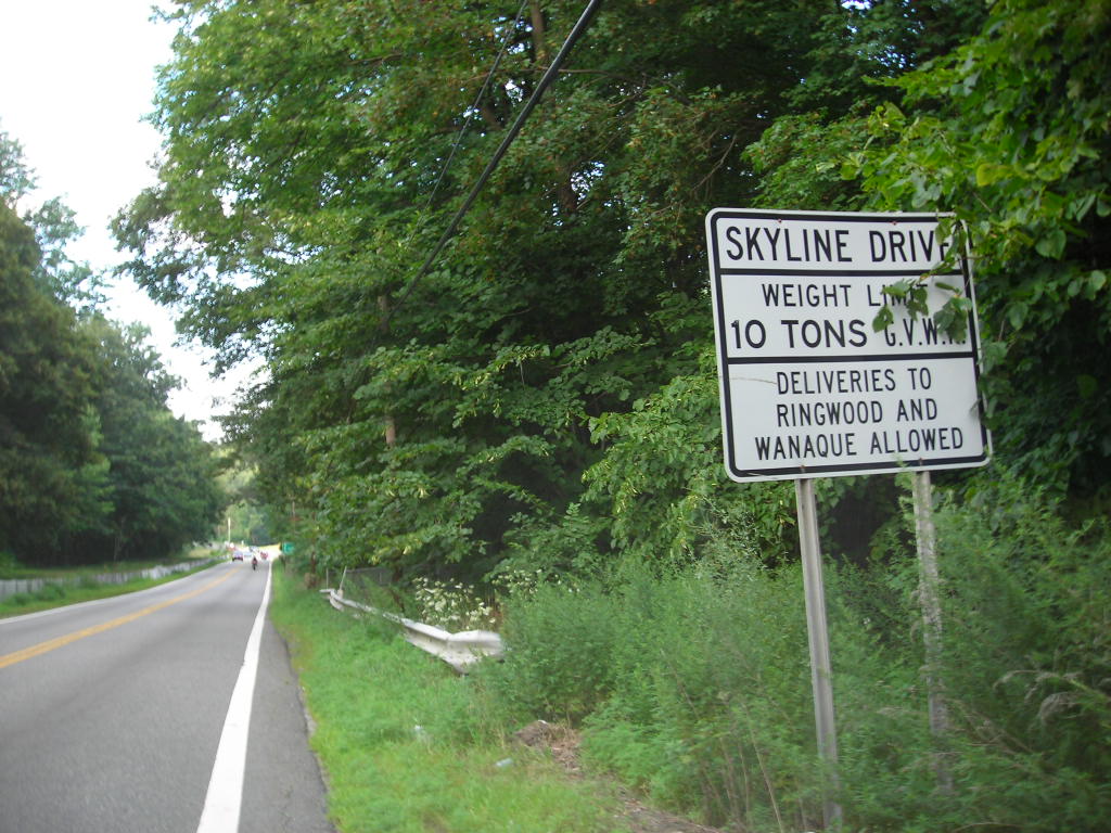
The road offers a brief view of the Manhattan skyline, 20 miles (32 km) away, while heading southbound. The steep and narrow road is often impassable in winter due to ice and snow. As of April 1, 2001, the New Jersey Department of Transportation imposed a ban on trucks exceeding 10 tons from using Skyline Drive. This ban follows an incident in December 2000, in which three Ringwood residents were killed by a 40-ton dump truck that had lost control on the roadway and fell to its side.
Contents
Route description
 Signage for Skyline Drive along County Route 511 in Ringwood. The open signage mentions Open for the conditions of the roads
County Route S-91 begins at an intersection with U.S. Route 202 (co-signed as Bergen County Route 91 due to county maintenance) in the community of Oakland. The route heads westward as West Oakland Avenue, crossing over the tracks for the New York, Susquehanna and Western Railroad and paralleling to the south of Interstate 287. After intersecting with the ramps from Exit 58 of the interstate, Route S-91 continues westward through a large residential and commercial portion of Oakland. The route crosses over the nearby Ramapo River and continues westward to a traffic light with Skyline Drive in Oakland. At this point, Route S-91 continues northward along Skyline Drive, crossing under the mainline of Interstate 287 and entering the nearby partial cloverleaf interchange. After the interchange, Skyline Drive continues northward and ascends through the nearby woodlands, passing by residences in spurts. The route begins to progress its way to the northwest, crossing into the nearby Ringwood State Park. While traversing the park, Route S-91 and Skyline Drive cross the county line into Passaic County, where the route becomes County Route 692 for a short distance. After making a gradual curve to the northeast, Route 692 crosses back into Bergen County and becomes Route S-91 once again. Continuing a short distance through the state park and after crossing a dirt road, Skyline Drive crosses the county line once again.[3]
 Signage denoting the former alignment of New Jersey Route 208 along Skyline Drive in Ringwood
After crossing back into Passaic County, Skyline Drive (and County Route 692) continue northward through Ringwood State Park before curving its way out of the northern reaches of the park. At this point, the highway enters the borough of Ringwood, where the dense forestry changes back to residences. The route continues through Ringwood, crossing several local streets and turning to the northwest once again. Just before the intersection with Countryside Lane, Skyline Drive turns to the northeast and once again, enters the dense forestry. After crossing through a large residential complex, the highway continues curving its way northward, turning westward one final time at the intersection with Erskine Road. After the curve, Skyline Drive and County Route 692 continue the short stretch westward, terminating at County Route 511 (the Greenwood Lake Turnpike) in the community of Ringwood, near the shores of the Wanaque Reservoir.[3]
History
The alignment of Skyline Drive was first designated as a state highway in the 1920s, as an alignment of State Highway Route 3. During the 1927 highway renumbering, the alignment was changed to State Highway Route S-4-B, a spur of State Highway Route 4, a cross-state highway.[4][5] However, this designation was changed once again after another state highway renumbering in 1953, when it was re-designated as part of State Route 208.[6][7] The alignment of Route 208 was planned to be upgraded into a limited access freeway through the Wanaque Reservoir and Greenwood Lake northward to the New York state line (to connect with the New York State Route 208's new freeway). There was also to be an interchange with Skyline Drive and West Oakland Avenue near the current interchange with Interstate 287. The $66.3 million project was canceled in the 1970s due to costs and environmental concerns.[8]
 Signage denoting the Skyline Drive truck limits
After being extended to West Oakland Avenue, Route 208 ended near Skyline Drive, where drivers could continue northward to Ringwood and Erskine.[9] The alignment of Route 208 remained along Skyline Drive during the 1960s, and was truncated in 1993 with the completion of Interstate 287. Route 208 was truncated to its current terminus with Interstate 287 in Oakland.[10] After a massive accident with a dump truck in December 2000, the New Jersey Department of Transportation passed rules banning trucks from using Skyline Drive in April 2001, to 10-ton limits. The ban however, did not include buses.[11]
Major intersections
County Location Mile[1][2] Destinations Notes Bergen Oakland 0.00  US 202 / CR 91 (Ramapo Valley Road)
Southern terminus of Skyline Drive and County Route S-91 0.73 I-287Exit 57 (Interstate 287) Passaic Ringwood 5.76 CR 511 (Greenwood Lake Turnpike)Northern terminus of Skyline Drive and County Route 692 1.000 mi = 1.609 km; 1.000 km = 0.621 mi See also
 U.S. Roads portal
 New Jersey portal
References
- ^ a b c d County Route S91 straight line diagram from New Jersey Department of Transportation
- ^ a b c County Route 692 straight line diagram from New Jersey Department of Transportation
- ^ a b Microsoft. Map of Overview map of Skyline Drive (County Route S-91 and 692) – Bing Maps (Map). Cartography by NavTEQ, Inc. http://www.maps.bing.com/maps/?FORM=Z9LH9#JmNwPTQxLjA1ODY3NjI0MjgyODM1NX4tNzQuMjUzMzQyNDg1MDU1MzMmbHZsPTEyJnN0eT1yJnJ0cD1wb3MuNDEuMDI2NDAyMTA5NzU2ODlfLTc0LjI0MDA0NjE5NzU2OTMxX25lYXIlMjBXJTIwT2FrbGFuZCUyMEF2ZSUyQyUyME9ha2xhbmQlMkMlMjBOZXclMjBKZXJzZXklMjAwNzQzNiUyQyUyMFVuaXRlZCUyMFN0YXRlc19fX2FffnBvcy40MS4wMjc5NDg4NTYzNTM3Nl8tNzQuMjUyMDM3NDA1OTY3NzFfbmVhciUyMFNreWxpbmUlMjBEciUyMCUyNiUyMFclMjBPYWtsYW5kJTIwQXZlJTJDJTIwT2FrbGFuZCUyQyUyME5ldyUyMEplcnNleSUyMDA3NDM2JTJDJTIwVW5pdGVkJTIwU3RhdGVzX19fYV9+cG9zLjQxLjA5MTI4NTE5ODkyNjkyNl8tNzQuMjY4NDM3NzcyOTg5MjdfX19fYV8mbW9kZT1EJnJ0b3A9MH4wfjB+. Retrieved 30 March 2010.
- ^ State of New Jersey, Laws of 1927, Chapter 319.
- ^ Williams, Jimmy and Sharon. "1927 New Jersey Road Map". 1920s New Jersey Highways. http://www.jimmyandsharonwilliams.com/njroads/1920s/images/1927_routes.gif. Retrieved 2008-10-08.
- ^ 1953 renumbering, New Jersey Department of Highways, http://en.wikisource.org/wiki/1953_New_Jersey_state_highway_renumbering, retrieved July 31, 2009
- ^ "New Road Signs Ready in New Jersey". The New York Times. December 16, 1952. http://img123.imageshack.us/img123/6933/19521216newroadsignsreaiu6.jpg. Retrieved 2009-07-20.
- ^ Maintaining Mobility. Tri-State Transportation Commission. 1975.
- ^ Wright, George Cable (May 15, 1960). "ON JERSEY'S ROADS; Motorists En Route to State's Resorts Will Find Many Improvements" (Fee required). The New York Times. http://select.nytimes.com/gst/abstract.html?res=F00A1EF639541A7A93C7A8178ED85F448685F9&scp=18&sq=%22route%20208%22&st=cse. Retrieved 2009-08-25.
- ^ Anderson, Steve. "NJ 208 Freeway". Eastern Roads. http://www.nycroads.com/roads/NJ-208/. Retrieved 2007-03-19.
- ^ "Briefing: Transportation; Skyline Drive Truck Ban". The New York Times (New York, New York: Time Warner). April 8, 2001. http://www.nytimes.com/2001/04/08/nyregion/briefing-transportation-skyline-drive-truck-ban.html. Retrieved 30 March 2010.
Categories:- Transportation in Bergen County, New Jersey
- Transportation in Passaic County, New Jersey
- Ramapos
- Streets in Passaic County, New Jersey


Wikimedia Foundation. 2010.